Photo: richard johnson / iStock / Getty Images Plus / Getty Images
GNSS technology has become integral to construction work. In particular, firms rely on GNSS signals in four critical areas.
Site surveys
Surveying always has been a foundational aspect of construction planning. Mapping and staking the construction site is essential in preparing to break ground and build on site. Surveyors begin the task of bringing engineering plans from vision to reality.
This work may take place from the air and on the ground, and it now typically involves a vast array of tools to ensure accuracy, including drones, cameras, lasers, sensors, and GNSS signals. The data from GNSS are critical in helping surveyors and engineers create “digital twins” — virtual representations of the physical site they can update in real time to ensure the site matches the plan.
Robotics
Robotics have further transformed the work of construction, both in terms of site surveying and the work of building. Rovers, drones and construction robots can execute various tasks to improve project efficiency and save money.
Once again, GNSS signals play a critical role in ensuring robots carry out their tasks effectively and accurately. Land surveying rovers, for instance, rely on real-time satellite data to navigate construction sites and mark spots for construction with pinpoint precision.
Damage prevention
Construction work is highly invasive, penetrating the ground where hidden power, gas and water lines lie. Misfires during this process can have substantial cost implications or even be life-threatening for construction crews.
Construction firms can use GNSS receivers and other complex instruments to prepare for excavation. These tools provide detailed location information for underground pipes and wires and ensure contractors don’t damage critical underground infrastructure and cause costly delays or dangerous work conditions.
Engineers also can use GNSS data to pinpoint where future utility lines will be, ensuring construction does not get in the way of laying pipelines to bring the constructed building online.
Site inspections
GNSS data continue to play a critical role while construction work unfolds. As builders lay foundations, frame buildings and add finishes, engineers and inspectors can collect site reports and use satellite data to update digital twins and verify the work is on track.
With updated and accurate digital twins, planners have a real-time view of the work in progress, which they can use to inform plans, budgets and timelines as the project unfolds.
ANELLO Photonics and Key Dollar Cab, an OEM and technology integrator, have formed a strategic collaboration to bring ANELLO’s optical gyroscope technology to agriculture applications. The collaboration focuses on enhancing positioning accuracy in orchards and other high-value crop environments with limited GPS availability.
The partnership aims to address the growing demand for more robust and accurate positioning systems in orchards where precise navigation is crucial for optimizing operations and maximizing yield.
Optical gyroscope technology offers several advantages compared to traditional positioning systems, including improved accuracy, reliability and robustness in challenging agriculture environments. The optical gyroscope technology and positioning solutions integrated with Key Dollar Cab’s agricultural machinery and equipment is designed to offer farmers improved precision and efficiency in various orchard management tasks, including planting, spraying, fertilizing and harvesting.
A roundup of recent products in the GNSS and inertial positioning industry from the May 2024 issue of GPS World magazine.
SURVEY & MAPPING
Photo: Virtual Surveyor
UAV With planimetric survey capabilities
The Virtual Surveyor version 9.5 now allows users to quickly and accurately survey 2D features from UAV orthophotos and add them to the 3D topographic model generated from the same data set.
True 2D features, for example, include the paint striping that delineates parking lot spaces and road lanes. Other objects that exist in 3D on the ground but can be surveyed in two dimensions include building footprints and tree canopies. These features are designed to offer a new level of efficiency to the UAV surveying process in Virtual Surveyor.
Virtual Surveyor provides users with an end-to-end workflow to conduct 3D surveys from UAV imagery. The integrated Terrain Creator app photogrammetrically processes UAV photos to build survey-grade digital surface models (DSMs) and orthomosaics. No third-party software is needed to create surveys from UAV data. The system is ideal for users in construction, surface mining and excavation projects.
Positioning System Incorporates an anti-jamming and interference monitoring system
SXblue GLOBE merges GNSS and GIS to deliver positioning accuracy, efficiency and reliability in challenging field conditions using a 448-channel GNSS board.
Its advanced multipath mitigation aims to reduce the effects of signal reflection and ensure the integrity of positioning service, even in GNSS-challenged environments. The SXblue GLOBE incorporates an anti-jamming and interference monitoring system, safeguarding against disruptions and offering uninterrupted operation in any scenario.
The system uses global or local coverage of correction services, satellite-based augmentation system (SBAS), and real-time kinematics (RTK) with an update rate of up to 100Hz. This seeks to provide users with enhanced accuracy and reliability in positioning activities. Sxblue GLOBE features a Wi-Fi connection, which allows its parameters to be easily configured via a web user interface.
3D Mapping Software With expanded visualization tools
The Surfer mapping and 3D visualization software now features upgraded 3D visualization capabilities. The upgrades are designed to give users a complete picture of collected subsurface data. The expanded visualization tools in the latest Surfer version make it easier to create 3D grid files for viewing and analysis of drillhole data.
Surfer can be used for environmental consulting, water resources, engineering, mining, oil and gas exploration and geospatial projects.
With these upgrades, users can render 3D grids as a series of blocks, which can be colorized by a select variable. Images of cross sections, profiles and other features can be imported directly into 3D View and oriented in any direction or angle. To isolate certain features in the 3D grid, users can assign NoData to portions of the grid with a variety of methods. This allows users to eliminate unwanted data in a 3D grid outside of field boundaries, well locations, or above or below specific surfaces, such as a water table, topography, or lithologic layer.
Digital Twin Platform Shows roadway incidents in real time
The Flow RT is a real-time digital twin platform designed to provide agencies with instantaneous alerts and insights for better decision-making. The platform allows traffic managers to view traffic conditions, signal operations and roadway incidents in real time, at scale across entire regions.
Flow RT integrates seamlessly with the company’s solutions, including traffic signal management, roadway safety management and mobility management. Powered by connected vehicle data from industry-leading partners, including TomTom, the platform offers up to five times higher vehicle data penetration rate than the previous industry standard. Flow RT also provides alerts and notifications while offering data-driven decision support, ensuring agencies can make the best decisions using the most accurate, reliable and instantaneous insights with and without infrastructure connectivity.
INS With an integrated acoustic resonance air speed sensor
Inertial Labs has integrated the FT Technologies FT743-D-SM acoustic resonance air speed sensor into its inertial navigation systems (INS).
This integration aims to improve the accuracy of horizontal air speed estimation for multi-rotor UAVs, even in GNSS-denied environments. The FT743-D-SM airspeed sensor is a digital anemometer-based solution that can estimate airspeed incoming from any direction using acoustic resonance technology, which is immune to vibration and external acoustic noise. The airspeed magnitude and direction allow the INS to estimate horizontal air speed in the longitudinal and lateral axes.
The INS receives aiding data from the dual-axis airspeed sensor and experiences significantly less position drift compared to a dead reckoning alternative in GNSS-denied environments, the company said. The system can be used in mission-critical roles in multiple military or defense applications, as well as in civilian applications such as wind energy, marine navigation, UAVs and dynamic positioning systems.
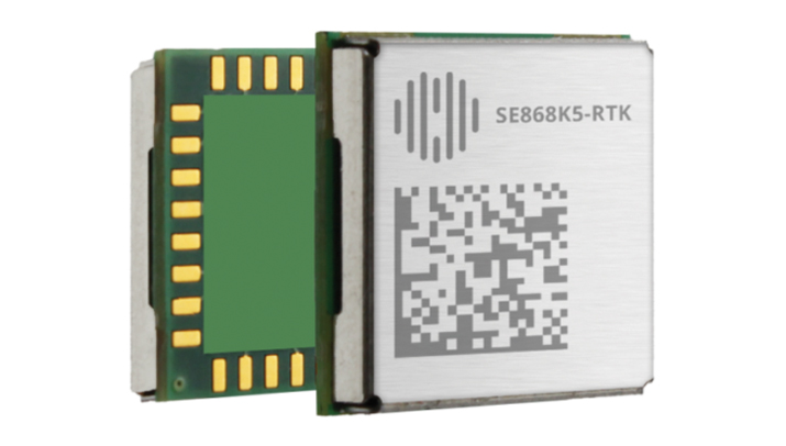
The SE868K5-RTK module is a GNSS receiver capable of centimeter-level accuracy. It is designed for seamless operation near cellular or other radios and is suitable for precision applications.
At 11 x 11 mm, the module’s compact form factor offers adaptability in size-constrained scenarios and easy migration within the xE868 product family. It is designed to offer high-performance navigation, even in challenging RF conditions. The solution can be integrated into applications such as wearables, UAVs, robots, fleet tracking and precision agriculture.
The SE868K5-RTK is a multifrequency and multi-constellation positioning receiver module with RTK capabilities that enhance positioning accuracy. By harnessing dual frequencies — L1/E1 and L5/E5 — the module offers improved location precision and reduces multipath effects.
In partnership with Swift Navigation, the SE868K5-RTK module utilizes local base stations or Swift’s Skylark precise positioning service for corrections, which offers reliable centimeter-level accuracy across an extensive coverage area. The integration and Telit Cinterion’s cellular modules and NExT connectivity services offer continuous and accurate correction data delivery to the GNSS module.
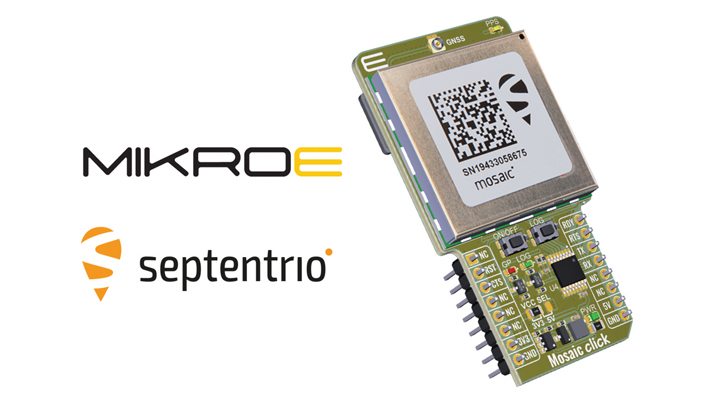
Upgraded Click Board Now with an integrated GNSS receiver module
The Septentrio mosaic-X5 GNSS receiver has been integrated into the MikroElektronika (MIKROE) Mosaic Click board.
Mosaic Click is compatible with mikroBUS socket standard, allowing plug-and-play prototyping and reduced time-to-market. The mosaic-X5 receiver uses triple-band GNSS technology to achieve centimeter-level RTK accuracy, even in challenging environments. Its anti-jamming and anti-spoofing technology protects the receiver from malicious or accidental radio interference. It is ideal for applications where safety is a concern, as well as autonomous and mission-critical applications of systems such as UAVs or industrial robots.
The mosaic-X5 receiver tracks all available GNSS constellations and is protected by Septentrio’s AIM+ anti-jamming and anti-spoofing technology. Full GNSS raw data and positioning are delivered at a high update rate of 100Hz and with low latency, which is critical for autonomous movement and maneuvering.
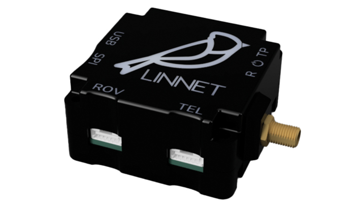
RTK Positioning Module Supports all GNSS constellations
The Linnet mosaic-X5 is a multi-band module featuring the Mosaic-X5 receiver by Septentrio. It receives signals from all major constellations and can be used both directly on the rover and as a base station. The system can achieve centimeter-level positioning accuracy and attain precise positioning even in low-coverage zones and harsh vibrations and shocks.
The mosaic-X5 module is a 448 channels all-in-view receiver that supports all GNSS constellations, SBAS and QZSS, as well as built-in on-module support for other L-band correction services. The Linnet Mosaic-X5 features anti-jamming protection and anti-spoofing built-in and embedded spectrum analyzer.
The module can be used in a variety of applications, including tracking, surveying, autonomous navigation, ground robotics, precision agriculture and machine control.
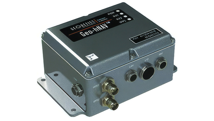
Geo-hNAV is a rugged, hybrid dual-GPS-aided INS. It offers consistent position and attitude measurement accuracy whether the platform is static or moving. The Geo-hNAV combines the Geo-iNAV INS with the Geo-Pointer dual-antenna heading system.
For stationary or slowly moving platforms, precise heading is derived from GPS measurements using two GPS antennas rigidly mounted on the platform, separated by a typical distance of 1 to 3 meters. In dynamic conditions, the combination of GPS and IMU seeks to provide enhanced position, velocity and attitude measurements. The system can be used for geo-positioning onboard sensors on static, low and high dynamic platforms such as aerostats, boats and tanks.
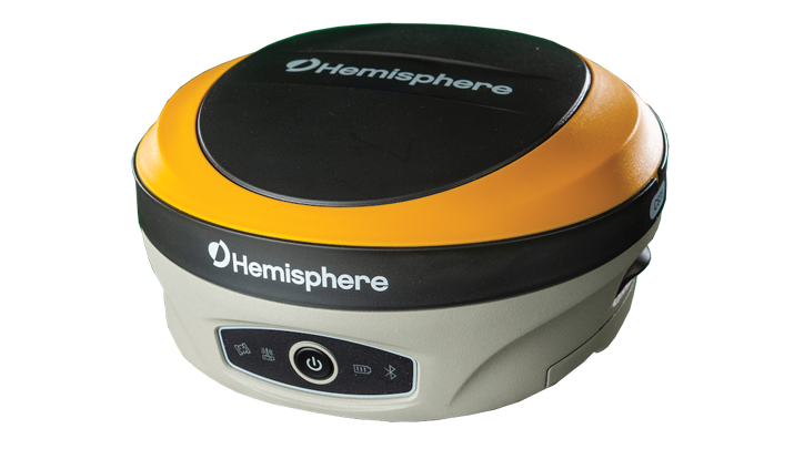
The C631 is a multi-GNSS, multi-frequency smart antenna. The C631 provides robust performance and high precision in a compact and rugged package. With multiple wireless communication ports and an open GNSS interface, the C631 can be used in a variety of operating modes.
C631 can be used as a precise base station sending RTK to existing rover networks. Users can turn the C631 into a lightweight rover by connecting it to a base via UHF radio or Wi-Fi network. The built-in web user interface can be used to control and manage the receiver status and operation and upgrade the C631 with new firmware and activations.
Atlas is a global correction service that can be added as a subscription to the C631. Atlas delivers worldwide centimeter-level correction data over L-band communication satellites.
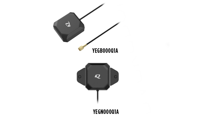
The YEGB000Q1A and YEGN000Q1A active GNSS L1 and L5 antennas are designed to tap into L1 and L5 frequency bands for advanced navigation applications. These antennas, operating within the 1164-1189 MHz and 1559-1606 MHz frequency bands, are designed to support a variety of installation methods, catering to diverse application needs with options for screw mount, adhesive mount, magnetic mount and various cable connections.
The antennas are part of a broader release that includes the YEMN016AA and YEMN017AA 5G 5-in-1 combination antennas, which also feature GNSS capabilities.
These GNSS antennas are crucial for applications that require high levels of navigation accuracy, such as autonomous vehicles, UAV delivery systems and precision farming.
The TW5387 industrial-grade smart GNSS antenna integrates the Quectel ST TESEO V GNSS receiver chipset onto the Calian compact smart GNSS antenna platform. It is designed to offer dual-band GNSS, eXtended filtering, low phase center variation, low signal-to-noise ratio and dual feed and patch for strong multi-path rejection.
The TW5387 comes with RTK rover capability and a built-in IMU for sensor fusion. It is designed to minimize RF impairments that affect the performance of the GNSS receiver and provide GNSS coordinates to the host system over a robust digital interface for noise resilience.
TW5387 is suited for automotive, UAV, robotics and defense applications that require high precision location and timing. TW5387 is compatible with N-RTK correction services such as Point One Navigation’s Polaris and Swift Navigation’s Skylark. It tracks GPS, Galileo, BeiDou and L1/L5 band operation and is housed in an industrial-grade IP69K enclosure.
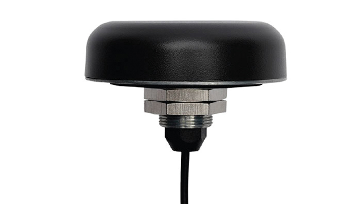
The PEANGPS1005 is an active GPS/GNSS multi band L1/L2/L5 antenna with 47.5 dBi overall gain. It is IP69K rated, light weight and designed for surveying. This GPS/GNSS antenna is suited for harsh operating environments where stability and reliability of GPS/GNSS signal is required.
This antenna operates in the 1.164-1.3GHz and 1.525-1.615GHz bands, meeting GPS L1/L2/L5, GALILEO E1/E6/E5a/E5b and GLONASS L1/L2/L3 requirements. The PEANGPS1005 antenna has an integrated LNA with 2 dB noise figure and LNA gain of 40 dB.
The antenna has an axial ratio of 3 dB and can track visible satellites under extreme conditions, which is ideal for UAV navigation, autonomous tracking or GIS surveying.
Paving and Mining Solution Meets DOT smoothness standards
The MC-Max asphalt paving and MC-Max milling solutions offer modularity, simplified configurations and advanced feature sets to increase productivity in asphalt paving and cold milling applications.
The MC-Max Asphalt Paving and MC-Max Milling systems, which are made up of , total stations, displays and other high-precision sensors, are built with the new MC-X machine control platform. Users can choose from entry-level 2D systems that follow a reference, such as a string or a curb, or automated solutions that track a paver or miller in 3D.
Contractors can pave and mill at variable depths while meeting smoothness standards mandated by the U.S. Department of Transportation (DOT) smoothness standards. The solutions also include MC-X licensing options. The technology is compatible with OEM CAN-based systems and has expanded to include compatibility with additional aftermarket systems.
It is equipped with Topcon Virtual Ski intelligence software designed to simplify workflows in specific resurfacing applications, such as rural roads where there are fewer fixed points or intersections to match up to.
Reality Capture Platform Generates detailed 2D and 3D models
This UAV reality capture platform collects data through FlytBase UAVs and generates detailed 2D and 3D models on SkyeBrowse, a UAV reality capture platform.
The platform uses SkyeBrowse’s videogrammetry technology to quicly convert UAV video footage into 2D maps and 3D models, making it ideal for emergency response scenarios where rapid documentation is critical. The platform integrates seamlessly with beyond visual line of sight (BVLOS) systems, enhancing both the speed and quality of data-driven strategies in critical operations.
The E400 fixed-wing VTOL ISR UAV now features a 360° camera option. Partnering with NextVision, the Event 38 UAV now offers a range of EO/IR Gimbal camera options for seamless integration with the E400 platform.
NextVision’s gimballed EO/IR cameras capture visual and thermal imagery and video. The UAV provides live streaming directly to ground stations for continuous monitoring capabilities.
The 360° EO/IR camera integrated onto the E400 ISR can be used for search-and-rescue missions, suspect pursuit, emergency management and disaster response. The E400 ISR, built with a military-grade carbon fiber frame, offers durability for rugged field applications and allows for extended flight durations without the need for frequent recharging. It is suited for surveillance and security applications. It features electric propulsion and minimal noise emissions for discreet flight operations.
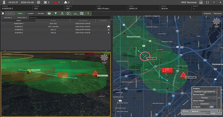
Enhanced BVLOS System Offers situational awareness to UAS operators
IRIS Terminal now features Echodyne radar technology designed to enhance Beyond Visual Line of Sight (BVLOS) operations for unmanned aerial systems (UAS) in Advanced Air Mobility (AAM) applications.
The integration seeks to provide situational awareness to UAS operators by visualizing all airspace movement, cooperative and noncooperative, to ensure safe and reliable UAS operations.
IRIS Terminal, now in its second generation, has been adapted from its defense origins to the enterprise UAS sector for visualizing airspace traffic, as well as controlling uncrewed systems in its GCS format. Airspace traffic is visualized inside IRIS Terminal’s multiple viewing configurations, along with features such as detect-and-avoid (DAA) sensor footprints, terrain awareness and potential conflict warnings.
The Inertial Labs’ RESEPI lidar remote sensing payload instrument GEN-II has been integrated into Sony’s Airpeak UAV.
The partnership seeks to enhance Airpeak’s ability to produce detailed aerial maps and 3D models.
Tailored for professionals, the lidar system integrated into Sony’s Airpeak UAV will significantly enhance workflow efficiency and data accuracy, particularly in sectors such as construction, agriculture, and filmmaking, according to Inertial Labs. The system allows for extensive data handling and facilitates longer durations of data collection without frequent offloads. The UAV can be used for surveying, mapping and cinematic videography.
Leica Geosystems, part of Hexagon, has released the iCON 120 machine smart antenna, designed to deliver scalable and flexible machine control solutions for construction professionals.
The iCON 120 is a GNSS antenna intended for integration within the existing Leica MC1 platform, extending the company’s machine control solution offering to cover more applications and machine types.
With increasingly stringent project budgets and specification requirements, it is essential to incorporate intelligent solutions at every stage in major construction operations. Rationalized and connected hardware and software are being used to increase productivity, efficiency and safety, responding to the rising demand for adaptable, easily accessible and customizable machine control systems.
Many construction machines, such as compaction rollers, generally operate at only sub-meter accuracy, without heading. With the new iCON 120, operators can benefit from a tailor-made, Leica MC1-based machine control, allowing for more streamlined operations and consistent workflows with a variety of heavy construction equipment and application requirements.
Leica iCON 120 users can start with a single GNSS solution using a satellite-based augmentation system (SBAS), such as WAAS or EGNOS, or a HxGN SmartNet service. The HxGN SmartNet family offers network real-time kinematics (RTK) with RTK bridging and precise point positioning (PPP) services that work exclusively with Leica Geosystems GS sensors. The new smart antenna can be easily switched, with quick mounting and dismounting, between Leica MC1-prepared machines.
Users can optionally upgrade their basic-level machine-control solution with the Leica CR50 communication unit to receive RTK correction data via radio or modem. The CR50 features a web interface, automotive ethernet communication, worldwide cellular modem and integrated dual-frequency UHF radio.
Topcon Positioning Systems has launched MC-Max asphalt paving and MC-Max milling solutions. The systems offer modularity, simplified configurations and advanced feature sets to increase productivity in asphalt paving and cold milling applications.
The MC-Max Asphalt Paving and MC-Max Milling systems, which are made up of GNSS receivers, total stations, displays and other high-precision sensors, are built with the new MC-X machine control platform. Users can choose from entry-level 2D systems that follow a reference, such as a string or a curb, or automated solutions that track a paver or miller in 3D.
Contractors can pave and mill at variable depths while meeting smoothness standardsmandatedby the U.S. Department of Transportation (DOT) mandated smoothness standards. The solutions also include MC-X licensing options. The technology is compatible with OEM CAN-based systems and has expanded to include compatibility with additional aftermarket systems, according to Topcon.
It is equipped with Virtual Ski intelligence software designed to simplify workflows in specific resurfacing applications, such as rural roads where there are fewer fixed points or intersections to match up to.
“Our mobile road scanner easily creates a 3D model of the existing road surface, which can be sent to the machine using our Sitelink3D cloud solution,” said Murray Lodge, executive vice president, Topcon. “Simply scan and mill or lay the base layer and let the milling machine or the paver do the surface design job instead of all that data having to go back to the office for the design work. This results in the production of a smooth surface more quickly with less effort and significant time savings. Thanks to the flexible, digital calculation, which follows the road direction even in tight curves, the overall quality and lifespan of the resurfaced road is improved.”
The company also released the RD-MC road construction machine control solution, which can be utilized in areas without satellite reception by using a local positioning system (LPS) solution to offer precise positioning when working in challenging GNSS coverage areas.
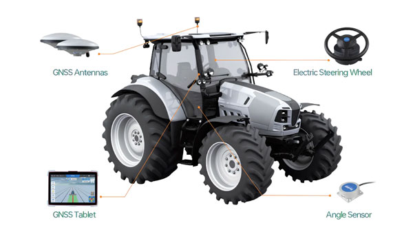
ComNav Technologies has introduced the AG502 automated steering system. It integrates advanced satellite reception, positioning, navigation and automatic driving to meet the diverse demands of modern agriculture.
The system consists of a GNSS tablet, an electric steering wheel, two angle sensors and two GNSS antennas, offering a plug-and-play capability with simple instillation and calibration. It is equipped with a ComNav SinoGNSS to support full-constellation and multi-frequency tracking.
It is designed to withstand harsh outdoor agricultural environments. With waterproof and dustproof properties, the system offers weather resistance and durability in diverse conditions.
The AG502 is equipped with connectivity modules, featuring a 4G modem alongside UHF radio. It offers farmers the flexibility to access real-time kinematics (RTK) correction sources from local RTK networks or GNSS RTK base stations. It uses the combined GNSS+INS terrain compensation technology to provide automated steering accuracy, with a precision of 2.5 cm. This level of precision makes the system ideal for tasks such as ditching, planting and harvesting.
For the remotely located or often network-lacking fields, the system offers a reliable precision point positioning (PPP) solution, which supports PPP-HAS and PPP-B2b service. It also features intuitive and user-friendly 2D/3D software, streamlining the learning and operation process for easy start-up. It supports various work modes such as straight, curved, automatic u-turn and pivot to accommodate diverse farmland and work requirements.
ComNav offers comprehensive training videos of the AG502. In the event of technical challenges, users have access to remote technical support or can reach out to local dealers via phone, email or messaging apps for prompt assistance.
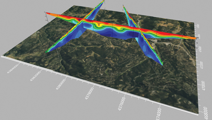
Working in agriculture means facing a variety of challenges imposed by nature. Unfavorable weather conditions, such as irregular rainfall, strong winds and hail, are common obstacles for producers and companies involved in the sector. Additionally, a recent rise in solar flares has caused headaches for those who rely on precision agriculture technologies, such as satellite positioning technologies, to operate farm machinery.
Ionospheric scintillation is a phenomenon that causes rapid and irregular variations in the power of radio frequency signals that travel through the ionosphere, a region of the Earth’s atmosphere that has ionized particles, which makes it capable of reflecting and refracting radio signals, such as those used in satellite communications and GNSS.
These variations in the power of radio signals occur due to disturbances in the concentrations of free electrons in the ionosphere, which various factors, including solar activity, geomagnetic events and weather conditions in the upper atmosphere can influence. Fluctuations in the electron density of the ionosphere cause distortions in radio signals, leading to fluctuations in the signal’s power and phase. Some of the consequences of this phenomenon are almost imperceptible, such as a deviation of 1 m or 2 m in the position calculated by your cell phone’s GPS receiver. When it comes to precision farming, however, a few centimeters of error in machine positioning can severely impact operations by increasing input waste, reducing efficiency and decreasing production.
Many farmers, especially in Brazil, plant and harvest two crops a year, and rely on precision farming technology to sow and harvest quickly and accurately. With an estimated production of 317.5 million tons for the 2023/24 harvest, according to the Brazilian National Supply Company (Conab), these producers have buffer time to keep their machines idle. During planting and harvesting periods, farms often operate 24 hours a day, 7 days a week, and precise positioning via GNSS is essential for using solutions such as auto-steering and traffic control. When ionospheric scintillation affects the performance of location systems, it causes delays and inaccuracies, directly impacting the productivity of farms and damaging the operations’ efficiency and profitability.
To mitigate the impacts caused by ionospheric scintillation, as well as other problems that can affect receivers, farmers have several GNSS correction options at their disposal, such as precise point positioning (PPP) and real-time kinematics (RTK). These alternatives aim to increase positioning accuracy for high-precision applications and create different levels of resilience against ionospheric interference. However, it can still affect these services, causing errors in the receiver’s position calculations. In RTK systems, which rely on carrier phase measurements, scintillation can drastically impair positioning accuracy, especially at greater distances from the base station.
To overcome scintillation challenges, PPP positioning is a more reliable option. Unlike RTK, PPP estimates ionospheric errors at the receiver’s location and does not depend on corrections from a local base station. This allows users to achieve high precision anywhere within the global coverage area, regardless of the distance from the base station. In addition, PPP takes into account the immediate ionospheric environment, making it less sensitive to changes in atmospheric activity.
A study by Hexagon | NovAtel in 2020, analyzed the ionospheric activity in the central-western region of Brazil, comparing a standard RTK positioning solution and the PPP TerraStar-C PRO positioning solution, developed by NovAtel. A 24-hour data collection captured the nocturnal impacts of ionospheric activity and yielded some insights: while RTK position performance at 10 km from the base station was degraded for many hours, showing errors of up to 25 cm, the receiver using TerraStar-C PRO corrections continues to experience centimeter-level accuracy, with shorter maximum deviations of up to 10 cm.
In summary, ionospheric scintillation is a growing challenge for precision agriculture, affecting the productivity and efficiency of agricultural operations. To minimize its impacts, the adoption of correction services such as TerraStar-C PRO has proven to be a resilient and reliable solution, allowing farmers to continue their operations accurately and effectively, even in challenging conditions. The development of increasingly advanced precision solutions is crucial to ensuring the success of agriculture.
Abracon has introduced a new series of GNSS RF antennas designed to elevate location-based services with enhanced accuracy and precision. This new lineup aims to outperform conventional GPS technologies by offering faster signal acquisition, improved tracking capabilities and reduced power consumption.
The antennas support a full spectrum of bands, including L1, L2, L5, and L-band data correction services. It can be used in a variety of sectors — such as agriculture, surveying, the Internet of Things (IoT), mapping, defense and aviation.
The technology is designed to meet the rigorous demands for precise location data across various applications. These antennas offer multi-band and multi-constellation support to ensure broad compatibility. With centimeter-level accuracy, these antennas are crucial for aerospace, defense, asset tracking, geolocation, precision agriculture and industrial IoT.
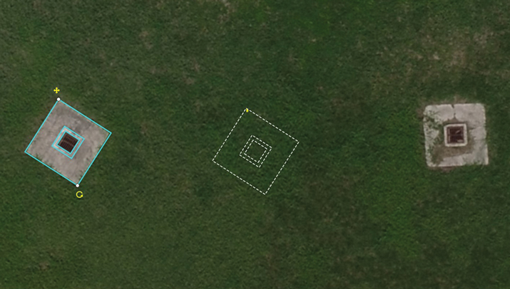
Building a solid foundation for any construction requires that the ground be adequately compacted and leveled. Construction workers and contractors operating earthmoving machines know it is nearly impossible to do that by eyesight alone. For a few decades, leveling was accomplished using rotating lasers mounted on tall tripods, which could typically cover a little more than 1,500 ft on a job site and laser receivers mounted on masts on the earth-moving machines. However, these systems only provide elevation, not position, and must be repositioned frequently.
Photo: Steer
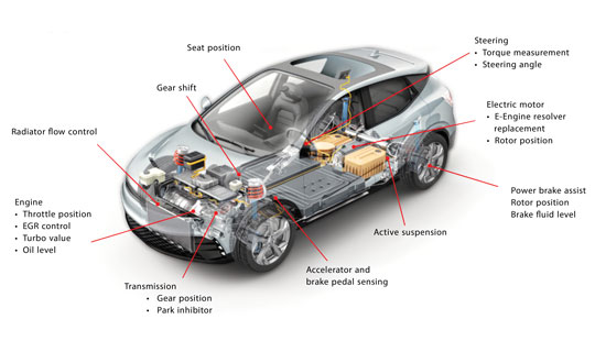
In recent years, laser leveling has been increasingly replaced by machine control systems that enable operators to compare the position of their machine’s blade with a digital grading map, and then guide it very precisely to cut the proper elevation. These machine control systems combine global navigation satellite system (GNSS) receivers, to provide the position of the machine; inertial navigation systems (INS), to bridge short gaps in GNSS availability and to provide the platform’s attitude (pitch, roll, and yaw); and a variety of other sensors, to determine the movement of the machine’s attachments, such as booms, arms and buckets.
In this month’s cover story, we feature perspectives on machine control from:
Microchip, which makes inductive position sensors that monitor the angular and linear movements of the attachments.
Septentrio, which makes the AntaRX series of smart antennas.
Besides grading, other areas for machine control include trenching at a specific depth, spot-bulldozing to better prepare a site for grading, mass excavation and contouring edges. Artificial intelligence (AI) will soon start taking over the operators’ duties, but that’s for a future article.
Controlling an earthmoving machine to perform a task requires knowing exactly where its bucket or blade contacts the dirt. Therefore, in addition to knowing the machine’s position, it is necessary to model, in real-time, the rotation at each pivot point and apply some mathematics and trigonometry.
Microchip makes an integrated circuit, known as an inductive position sensor, that is very well suited for machine control because it is not affected by the harsh conditions on most construction sites — temperature extremes, water, dust and dirt — and the vibrations caused by the machine itself. Additionally, it is not affected by the stray magnetic fields generated by electric motors, which are increasingly common on those machines.
Inductive position sensors are used in many automotive systems. (Photo: Microchip)
“We use our inductive position sensing to measure the angle or the linear movement of some sort of target to get a machine to perform its task,” said Mark Smith, product line manager for many different mixed signal products at Microchip. “For example, to control a blade on an earthmoving machine to do something, you need to have feedback about its current angle.”
Microchip also makes sensors for human interfaces, such as accelerator pedals in cars, which no longer have cables that run up to the motor. “Any sort of movement, such as the angles of rotation of a robotic arm, must be monitored and measured. Inductive position sensing is one of the up-and-coming ways to do it,” said Smith.
To direct a task, a central processing unit must then analyze and integrate the data from the sensors. For that, Microchip makes many types of computing elements — including mini-computers and microcontrollers.
“One of the things that’s coming up with many of these vehicles is ambient magnetic noise in the system,” said Smith, “because you’re next to electric motors these days. You want sensors that are immune to stray magnetic fields. We started with automotive, but we’re also seeing it now in industrial environments, including earthmoving vehicles.” Inductive position sensors, Smith said, are simpler, cheaper, lighter, and better able to withstand extreme temperatures than what they are replacing. “Also, because they are non-contact, the circuit board can be environmentally protected.”
Vibrations also are a concern. “There is an air gap between the target and the sensor itself,” Smith said. “We have an automatic gain control at the sensing side that is constantly adjusting the gain to get the maximum signal strength. This is a fast-moving control algorithm that can adjust the gain to ensure that the vibration does not affect the performance. When everything is operating at its maximum torque, this starts to matter.”
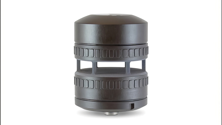
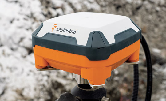
Septentrio’s AntaRx GNSS smart antenna — a box containing a receiver, an antenna and supporting electronics — is designed for machine automation and control in construction, precision agriculture and logistics. The smart antenna is enclosed in a rugged and compact housing for simplified installation. It can handle strong shocks and vibrations, which makes it ideal for harsh industrial environments such as construction and mining.
Septentrio’s AntaRx GNSS smart antenna is designed for machine automation and control. (Photo: Septentrio)
From the early stages of the product’s design and development process, Septentrio collaborated with a leading heavy construction machinery OEM, which provided feedback that helped improve the product’s specifications.
I discussed the use of AntaRx for machine control with Silviu Taujan and Danilo Sabbatini, both product managers for the product — the former with a focus on the machine automation market and the latter with a focus on INS.
What type of customers were you addressing?
Taujan: Mainly OEMs and integrators for machine control systems looking for a GNSS receiver with this kind of form factor to build into their control, automation or guidance systems.
Photo: Septentrio
A smart antenna is easy to install on various machines, correct?
Taujan: Yes. It saves space and the cabling is much simpler. We have a single rugged connector for power and data. Our latest generation of GNSS boards has dual antenna support. You can deploy one smart antenna and feed an auxiliary antenna — the AntaRx-AUX — into it for dual antenna heading capability.
Where does the INS come in?
Sabbatini: The GNSS/INS version is the AntaRx-Si3. It has an industrial-grade IMU that gives very high quality sensor fusion to bridge gaps in GNSS or correction signals. It also provides accurate attitude — pitch, roll and heading. We use this INS mostly for applications that require full 3D attitude, and for integrity and availability. It is built for one minute without GNSS.
Does all the processing happen inside the box?
Sabbatini: The output is a 100 Hz fused position. It will be fused by default to GNSS, plus IMU. The system can also accept the platform’s velocity as an extra input for sensor fusion. The output can include the raw GNSS position, the GNSS-only position and the raw IMU data.
What are some use cases?
Sabbatini: For INS, the most important use case is precision agriculture. For many ag robots, a smart antenna is the form factor of choice and most of them require INS sensor fusion. This INS product is the easiest to integrate because everything is fused inside the enclosure. Also, compared to other form factors, the customers do not need to worry about the lever arm between the antenna and the IMU because it’s inside the box, so it’s already taken into account. So, this form factor eliminates all the installation problems inherent to an INS system. The German company Sodex is creating a real time mapping system to install on top of machine controls. Another application is for users who want to close gaps in signals, especially in smaller machines that are going more often between buildings and close to structures.
Taujan: For the version without INS, we’re looking at the more mainstream machine control customers and applications. Even from the conceptual phase of this, we started by engaging with some customers, including one large OEM in the Asian excavator market. Then, from the aftermarket or integrator side, one machine control integrator integrated it into a system for asphalt pavers. These are not yet commercially available systems, but we’re in the development phase with them.
Gundersen & Løken AS, in Oslo, Norway, founded in 1899, develops equipment for the construction industry. It uses Septentrio’s AntaRx in its Dig Pilot 3D machine guidance system, which it began to develop in 2007. The company is now launching the next-generation DigPilot to assist excavator drivers. Its DigPilot Terra user interface and graphics offer a wide range of functionalities for efficient earthwork. The development of DigPilot Terra is funded partly by Innovation Norway.
DigPilot uses multi-axial CAN bus angle sensors on all moving parts — chassis, boom, arm and bucket — to calculate the position of the bucket tip with centimeter precision. The sensors are gyro-stabilized and hold firmware that predicts angles in the coming milliseconds based on angles from the previous milliseconds. These calculated angles are pushed to the computer in the cabin, which can visualize the bucket position in real-time.
DigPilot is a two-antenna system. Until now, it relied on two Septentrio GNSS antennas installed on the rear of the excavator — one to determine the machine’s position and one to determine its heading. These data are fed to the Septentrio GNSS receiver (rover) inside the machine, which also receives correction data via internet or radio. The data from the GNSS rover is pushed to the computer in the cabin and, when combined with the angular sensor data, provides the exact coordinates of the bucket tip and the delta value of the finished project.
Now, Septentrio’s AntaRx technology makes DigPilot’s installation simpler and more robust because the built-in GNSS rover in one of the rear antennas greatly reduces the amount of cabling and the number of connectors.
I discussed DigPilot with Eric Floberg, the company’s managing director since 2019 when he took over from his father, and Erik Sørngård, the company’s R&D manager, who has been working with Septentrio products for 12 years.
When did you start working with Septentrio on AntaRx for DigPilot? At what stage of deployment is it?
Sørngård: We began to discuss features about four years ago. At that time, we had worked with other Septentrio products for eight years. So, they appreciated our cooperation and wanted to show us where their next stage in development was heading. Last year, they approached us again, to see whether we could start looking further into it.
Floberg: We now have one system here for testing and we have experience from the previous Septentrio products, such as the rover GNSS receivers, which have always given us the best of accuracy. Of course, now, we see the potential to make our system more robust and simpler. As soon as we have sold out the existing Septentrio products, we will incorporate the AntaRx into our next-generation machine control system.
Is DigPilot receiver-agnostic, even though you have a preference for the AntaRx?
Floberg: All the connections, the cabling and the components themselves are exposed to very tough environments and stresses of different kinds, such as extreme temperatures and vibrations. So, reducing the number of components and connections and cabling would definitely give us a higher uptime, which is the most important thing for our end users.
Having the antenna and the receiver in the same box means less cabling and easier installation, correct?
Floberg: Definitely. The anti-theft aspect here is also very important. In certain parts of the world, you will appreciate the opportunity to easily remove it from your excavator or bulldozer when you leave at night.
What are the key challenges?
Floberg: This winter has been the toughest one in Norway in 30 years. We have also had the chance to do some testing in very low temperatures and harsh environments. When we see it work as well as it does, we feel very confident about it.
What accuracy have you been getting?
Sørngård: When it comes to machine control, we look at the end result on the tip of the bucket. We have several sensors, and we have to calibrate the machine accurately. The receiver is not the biggest contribution to the noise in the algorithms. We trust that the Septentrio receiver delivers accurate numbers, and we must push ourselves to make the rest of the system meet the same standards.
Floberg: On 30-ton or 40-ton excavators with booms up to 10 meters long we are able to get sub-centimeter accuracy, but the tip of the bucket in such a machine is 1 in thick. Of course, there are many other factors, such as the wear and tear of the machine.
Is DigPilot typically factory-installed or aftermarket?
Floberg: We’ll do both. We are often called by the distributor — say, Volvo or Hitachi or Kobelco — to install an integrated system.