Rx Network has launched TruePoint | REACH, an advanced, hardware-agnostic, cloud-based correction service designed to deliver centimeter-level location accuracy worldwide for various professional applications.
TruePoint | REACH offers precise centimeter-level positioning to enhance GNSS receivers’ performance in applications such as precision agriculture, machine control, mining, marine operations, UAV, GIS and more. The service is compatible with leading commercial off-the-shelf receivers using the RTCM 3.3 SSR and the 3GPP LPP SSR format. The company said key hardware partnerships are in the planning stages and will be announced soon.
TruePoint | REACH eliminates the need for users to set up their own base stations. Users can achieve centimeter-level accuracy by connecting receivers to the cloud while leveraging Rx Networks’ comprehensive global coverage.
Its correction engine is built to provide centimeter-level accuracy worldwide and can achieve sub-3cm precision in under 10 minutes. This makes it suitable for applications that require moderate initialization times for high-precision services.
A test version of TruePoint | REACH is available for those interested in assessing its capabilities. Users can sign up for a complimentary 30-day trial license through the Rx Networks website.
u-blox and Topcon Positioning Systems have formed a strategic partnership to develop a high-precision GNSS positioning service for the mass market.
The partnership was formed in response to the increasing demand for GNSS precise positioning across various applications. According to a recent EUSPA report, services enabled by GNSS devices are projected to generate approximately 80% of total GNSS revenues by 2033.
The comprehensive GNSS correction services will serve a wide range of applications requiring precise positioning, including automotive, industrial, robotics, construction, precision agriculture and mobility sectors. These services will integrate with u-blox’s current and future hardware products, as well as existing services such as PointPerfect.
Leica Geosystems, a part of Hexagon, has introduced the Leica iCON trades solution, which includes the iCS20 and iCS50 sensors designed for construction layout tasks. This solution integrates with existing Leica iCON build portfolio tools, offering tailored workflows for construction industry users.
The solution features the Leica vPole, allowing free movement during measurements. It works with the iCS50 to lock to the vPole using a unique combination of dot and stripe patterns. This system can automatically detect pole height and compensate for tilt, facilitating accurate point and line layouts even in difficult-to-reach areas. These features are designed to increase efficiency and precision in construction workflows.
Leica iCON trades has Hexagon’s 6-degree of freedom (6DoF) technology, traditionally used in industrial measurement, to the construction sector. This seeks to broaden the scope of applications in construction, offering new possibilities for improving workflow efficiency and ease of use.
The solution is designed for quick and efficient layout tasks, leveraging artificial intelligence (AI) to tackle current industry challenges. Features include computational photography for advanced imagery and realistic site documentation, while AI capabilities predict pole movement to enhance target lock and tracking, thereby streamlining the layout process.
TDK Corporation has unveiled the AXO314, its latest addition to the Tronics AXO300 accelerometer platform. This digital MEMS accelerometer is designed for industrial applications operating under shock and vibration, with a ±14 g input range.
The AXO314’s closed-loop architecture provides linearity and high vibration rejection, offering a low-SWaP, digital alternative to tactical-grade quartz accelerometers.
It has a one-year composite bias repeatability of 1 mg and bias instability of 4 µg, offering a robust, miniature and precise acceleration sensing solution for dynamic systems in harsh environments.
This new accelerometer is well-suited for land, sea and air surveying and mapping applications and GNSS-assisted positioning systems for aerial and ground vehicles.
Propeller, a cloud-based worksite mapping and UAV analytics company, has partnered with GEODNET to upgrade its survey-grade mapping solutions. By integrating GEODNET stations into the Propeller Corrections Network, Propeller can now deliver more precise data to its users in the construction, mining, aggregates and waste management industries.
Propeller has developed a fully integrated post-processing kinematic (PPK) mapping workflow for various commercial UAVs. Surveyors and contractors can visualize geospatial data from one central system using AeroPoint GPS-enabled smart ground control points and Propeller’s cloud-based platform.
GEODNET’s global network of more than 9,000 registered full-constellation GNSS reference stations offers Propeller users the GNSS corrections data needed to align AeroPoints and UAVs to thousands of published coordinate systems.
Propeller has completed the initial integration of GEODNET stations into its network, allowing both existing and new customers to benefit from these enhancements immediately.
u-blox and Nordian have significantly enhanced the PointPerfect GNSS correction service in Brazil by introducing L-band satellite delivery.
Previously, the PointPerfect GNSS correction service in the country was only available via cellular connectivity, which was limited by insufficient national network coverage. Users in Brazil can now access PointPerfect through L-band satellite and accelerate time-to-market using Nordian’s Precisio OEM Board. This allows users to access GNSS correction data streams reliably and cost-effectively in regions without cellular coverage, enabling advanced navigation applications requiring centimeter-level positioning accuracy.
PointPerfect is a PPP-RTK GNSS correction service that delivers 3 to 6 cm accuracy and convergence, making it ideal for autonomous farming activities such as operating automated machinery, field mapping and monitoring or navigating autonomous mobile robotics.
FJDynamics has launched the FJD AT2 Max auto-steer system. The system builds on the original AT2, which is already used in more than 30 countries. The AT2 Max features enhanced hardware with a larger 12.1-inch display and a powerful CPU processor. According to FJDynamics, these upgrades offer users faster processing for smoother operation on the screen while accurately navigating various terrains.
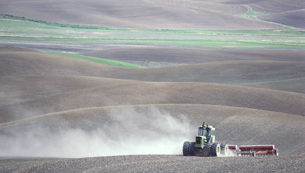
In addition to the AT2 Max, the new FJD ATS Precision Spray Autosteering System is built on FJDynamics’ proven autosteering technology, the ATS brings precision to crop protection by enabling tractors to spray accurately while automatically steering along desired paths. These models have been field-tested and are designed to meet various agricultural needs.
Swift Navigation and Bad Elf have partnered to deliver a complete, turnkey solution for high-volume and high-precision GIS data collection. GIS data allows workers across industries to create precise digital maps to improve worker safety and efficiency in construction, utilities and environmental management.
By combining BadElf’s GNSS receivers with Swift’s precise positioning solutions, field teams can capture centimeter-accurate location data on a tablet or smartphone Field teams can now more quickly and safely perform maintenance, dig trenches and avoid hazards such as high-voltage wires. wires.
Swift’s Skylark Precise Positioning Service is a cloud-based GNSS corrections service that enables accurate and reliable positioning for location-based products worldwide. Skylark is offered in multiple variants for multiple use cases, each with varying requirements for accuracy, coverage, power consumption and cost.
Bad Elf is a provider of GNSS receivers built for modern GIS mapping applications. Bad Elf’s line of Flex and Flex Mini receivers stream location data to any Bluetooth-equipped device, including Apple, Android, and Windows. When paired with Skylark, Bad Elf receivers deliver accuracy down to one centimeter and a fix within seconds. The combined solution is ideal for field workers requiring reliable high-accuracy positioning.
Trimble and Esri have extended their partnership to enhance collaboration in geographic information system (GIS) software, location intelligence and mapping. This ongoing effort aims to improve processes, support decision-making, and automate workflows for greener infrastructure planning, construction and operations for users.
The companies are exploring emerging technologies, particularly in industry data models that support accurate generative AI technologies and workflows. Trimble’s geospatial field systems, which collect location intelligence and 3D datasets, are enhancing workflow support in Esri ArcGIS Indoors and the ArcGIS Utility Network.
Trimble Unity — a new asset lifecycle management suite — leverages Esri’s GIS into construction project and capital planning, enterprise asset management and permitting solutions to improve how universities, healthcare facility operators, utilities and federal, state and local government jurisdictions track the asset management lifecycle.
Trimble and Esri also partnered with The HALO Trust, the world’s largest landmine-clearing non-profit organization, which combined Trimble’s high-accuracy mapping technology with Esri’s ArcGIS software to improve the capacity to locate and remove landmines and other explosive hazards, making communities safer.
The Global Earth Observation Decentralized Network (GEODNET) Foundation — the organization governing the blockchain-based global navigation network GEODNET — has entered new distribution and OEM agreements with AllyNav, Bad Elf, bynav, Sensori Robotics and Unmanned Life.
GEODNET’s blockchain-based global real time kinematics (RTK) and GNSS correction network consist of more than 7000 stations, which aim to provide a unique value proposition combining affordability, precision and reliability.
GEODNET will partner with AllyNav for precision farming; Bad Elf for surveying applications; bynav for automotive and internet of things (IoT) OEMs; Sensori Robotics for IoT robotic lawnmowers; and Unmanned Life for UAV orchestration.
The GEODNET ecosystem is undergoing continuous growth with an average of 100 to 200 GNSS reference stations added per week during the first half of 2024, the company says.
GEODNET is the world’s largest GNSS reference network for RTK-based positioning, according to the company. Standard GPS is usually off by two meters; however, devices connected to GEODNET’s global RTK network can achieve accuracy within 1-2 cm. Many IoT and autonomous applications, such as UAVs, smart mowers, and Advanced Driver Assistance Systems (ADAS), have shifted to RTK in place of standard GPS positioning.
GEODNET is a community-based Decentralized Physical Infrastructure Network (DePIN). Users can contribute to the network by installing and operating a reference station known as a satellite miner. Satellite miners deliver precise RTK correction data to devices equipped with GNSS receivers within a range of approximately 20-40 kms. GEODNET aims to provide the world’s most robust precision navigation system to a variety of industries, including self-driving cars, agriculture, consumer robots and more.
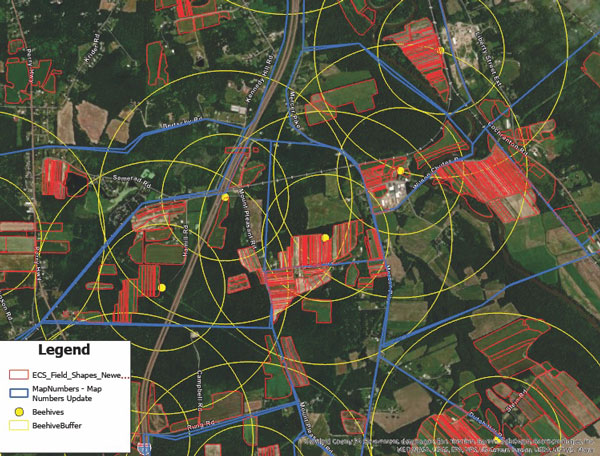
Ernst’s seed production relies on pollinators. Beehives are mapped and placed strategically across the fields to provide full coverage of seed crops. (Image courtesy of Ernst Seeds)
Every Monday and Wednesday, the team at Ernst Conservation Seeds gathers around maps to discuss which fields to harvest, which fields need treatments, and where to plant new crops.
On this 10,000-acre farm near the small town of Meadville, Pennsylvania, the company pioneered the propagation of 180 species of native wildflowers, grasses, and wetland plants to revive degraded land and provide wildlife habitat.
Now, the plants Ernst Seeds propagates are in high demand. Pollinator planting has become a trend worldwide, with the growing realization that flying bugs and birds are key to the survival of three-quarters of the world’s plants, including many we eat. Native plants are also being valued for nature-based solutions to protect soils from erosion and filter pollutants from stormwater.
Across its operation, Ernst Seeds embraces the science of agronomy and the use of geographic information system (GIS) technology to understand native plant species and grow them better, faster, and less expensively.
There’s a lot of experimentation that goes into growing native seeds and designing the right mix for each restoration project. “What we’re doing is going out and looking at existing plant communities to see what species grow together and how they’re doing it,” said Andy Ernst, vice president of Ernst Seeds. “Then there are lessons from our farming failures and successes. We make a lot of discoveries in our fields when we map yield data and the treatments we applied.”
Improving plant propagation
Typically, large farms focus on commodity crops like corn, soybeans, wheat, or cotton. At Ernst Seeds, the growing cycles of 180 species are tracked across 1,300 fields and 15 square miles.
“I realized a long time ago that with the complexity of our farm, we needed software to track it,” Ernst said. His early forays into traditional farm management software products were frustrating as most could not support so many crops. The software lacked the data management and analysis capabilities needed to discern best practices for seed crops no one else was growing.
Then in 2015, Ernst Seeds started using GIS. For operations, the ability to see fertilizer and spray assignments on smart maps helped the company identify places that required more or less treatment.
“There are a lot of accidental experiments when a row is skipped, there’s overlap, or a different chemistry is used,” Ernst said. “When we go out in the field, we can see areas that thrive and other areas that do poorly. With GIS, we can answer why.”
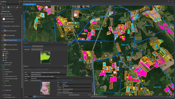
Katy Flaherty, an agronomy expert and the GIS manager at Ernst Seeds, developed a GIS-powered work order management system that guides each phase of production, from planting and fertilizing to applying pesticides and harvesting. The system uses a combination of ArcGIS Survey123, ArcGIS Field Maps, and ArcGIS Dashboards to record data and visualize trends. Flaherty also uses ArcGIS Pro to analyze data from the field, layering it with historical crop records and real-time soil and weather data to uncover correlations.
“When we plan our fields across four counties, there are significant differences in what crops do well from north to south,” Flaherty said. “It’s very spatial aware farming, and that knowledge transfers to recommendations for customers.”
In one instance, this detailed level of monitoring led to a decision to stop using a product that harmed some plants. In another case, improvements in propagation for a species proved so fruitful that smaller plots would meet the demand.
Smart maps guide the company’s planting locations, irrigation system maintenance, and harvesting schedule. Staff use smart maps to track plant maturity and time seed harvests. Unlike corn and soybeans, which can sit in fields for months, some native seeds have only three days of viable harvest. Knowing when and where to harvest is crucial. Ernst Seeds sells 70% of the seeds it harvests every year, putting the rest in the ground for the next crop cycle.
In ArcGIS Pro, administrators and agronomists view short-term plans and historical information. The map views allows them to analyze passes over fields, coverage of treatments, quantities of materials, water drainage, and other variables to inform treatment decisions. (Image courtesy of Ernst Seeds)
Filling gaps and expanding geographic reach
Calvin Ernst, Andy’s father, started the thriving conservation seeds business in 1964 with a Pennsylvania Department of Transportation contract to supply seeds to revegetate highway rights-of-way. Over the next 50 years, the company made wild seed collecting forays across the US to add plants to its offerings. As species count and seed supply grew, so did work with a broader list of customers, including state and federal agencies.
The company has developed seed mixes tailored to specific regions, such as Maryland, northern Virginia, and coastal North Carolina. These seeds are adapted to thrive in the local weather and soil. By choosing native seeds, restoration project managers ensure plants are well-suited to the ecosystem and more resilient to changing climate conditions.
“A simple philosophy is to avoid plants in your seed mixes that would be planted at the southern edge of their historical range,” Ernst said, speaking to the growing need for heat-adapted plants.
This commitment to innovation comes at a cost—it takes time to establish every new species. But insights from GIS can accelerate that timeline.
“It can take seven to 10 years to figure out how to grow something,” Ernst said. “If our observations cut that time down to five years, that’s a major win for us.”
Building native seeds capacity
One of the main challenges with native seed farming, according to Ernst agronomists, is the lack of knowledge of native seed production when compared to conventional row crops.
While the company has typically filled knowledge gaps itself, there have been times when an academic partnership has proved beneficial. For example, Ernst Seeds collaborated with researchers at the Center for Pollinator Research at Pennsylvania State University to identify the mix of flowering plants that could maximize pollinator food and breeding opportunities. The seed mixes developed through this partnership are now used across solar energy farms for revegetation.
The work on developing the right seed mix for solar farms made Ernst Seeds an ideal partner for the Virginia Solar Pollinator Program. Originally, Ernst Seeds was employed on the project by the Virginia Department of Conservation and Recreation to guide a mix of native seeds for Virginia, but that work expanded.
Ernst Seeds experts then worked alongside the Clifton Institute to gather seeds across Virginia, from the Coastal Plain to beyond the Blue Ridge Mountains. They recorded the location and conditions of their findings using a GIS-powered mobile app on their phones. This knowledge will help in planting along corridor projects, such as land beneath the electric transmission lines that will deliver energy from solar farms in rural areas to businesses and households in urban centers.
From its start with solar projects, the program evolved into the Virginia Native Seed Pilot Project to launch a native seed industry in Virginia. The program identifies local growers who can produce native seeds at a commercial scale and shows them how data from GIS helps guide best practices.
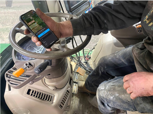
Tractor operators record their observations and have access to historical data as they work the fields. (Image courtesy of Ernst Seeds)
“Creating a GIS-centric culture at Ernst has changed how managers and operators work the fields,” Flaherty said. “We aren’t only looking at maps and numbers, we’re utilizing and making the data work for us every day.”
A data-driven approach to farming can be tough to instill in farmers working the same fields with the same approach for decades.
“Early on, we had pushback about the need to collect different information,” Ernst said. “Then in one meeting, we had a big lights-come-on moment when the answers we needed came from the data they’d been collecting. The guys were saying, ‘I know what we did there,’ but when we looked at the records their memory wasn’t as good as they thought it was.”
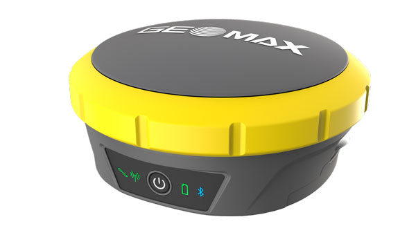
GeoMax Positioning has unveiled the Zenith60 Pro GNSS smart antenna, designed for surveyors and construction professionals.
It is a real-time kinematics (RTK) rover that features calibrated free tilt compensation to measure otherwise inaccessible points. The antenna is suited for harsh climates, urban areas, dense canopy coverage or other challenging terrains.
This multi-constellation, multi-frequency GNSS receiver features a GNSS board with more than 800 channels and IP68 protection against dust and water. It also connects with GeoMax total stations and X-PAD field software to create an efficient and flexible workflow.