Satellite images taken on June 25 and August 9 show an overview of southern Lahaina, Hawaii, before and after the recent wildfires. (Image: Maxar Technologies)
The number of wildfires this year only increases as the island of Maui, Hawaii has been struck by several wind-whipped wildfires fueled by Hurricane Dora. Flames engulfed parts of Hawaii the morning of Wednesday, August 9, destroying a centuries-old town and killing at least 90 people, reported NBC News.
The fires took people on the island by surprise on Tuesday, as it left behind burned-out cars on once busy streets and smoking piles of debris where historic buildings once stood. Residents and tourists were forced to evacuate the area – including some who reportedly jumped into the ocean to escape the flames.
The National Weather Service believes the combination of high winds and low humidity is what caused the dangerous fire conditions across the island.
Satellite images also were taken, showing hundreds of shops and homes burned to the ground. The satellite images focus on the historic Lahaina area, which dates to the 1700s and has long been a popular tourist destination rich with native Hawaiian culture.
In one image from Maxar Technologies, the historic area of Banyan Court in Lahaina appears to have been mostly reduced to ash. Some 271 structures were damaged or destroyed, the Honolulu Star-Advertiserreported, citing official reports from flyovers conducted by the U.S. Civil Air Patrol and the Maui Fire Department.
The fires in Maui come after scientists have warned that wildfires are becoming more frequent and more widespread across the globe.
Rising global temperatures and the increased extreme weather has led to a surge in the number of wildfires rapidly consuming extensive areas of vegetation and forested lands. Wildfires have recently spread across Greece, Italy, Spain, Portugal, Algeria, Tunisia and Canada — resulting in mass environmental and economic damage as well as human casualties.
A passenger on a plane captured the devastating wildfire that decimated the historic town of Lahaina, Maui.pic.twitter.com/h262jX92yq
ProStar Holdings Inc., a precision mapping company, has announced a technology integration with Leica Geosystems, part of Hexagon. The integration combines ProStar’s utility mapping software, PointMan, and Leica Geosystems’ precision GPS/GNSS receivers for GIS asset data collection.
The integration provides a precise and comprehensive data collection solution to capture, record and display the precise location of critical underground infrastructure across the globe using Leica Geosystems receivers.
“It only makes good business sense to work with other software providers and create mutually beneficial business relationships throughout the geospatial industry,” said Jason Hooten, GIS sales and support manager, Leica Geosystems.
Through the technology integration, PointMan now supports Leica Geosystems receivers for mobile devices running the Google Android operating system and Apple iOS, including the popular Zeno FLX100 plus GNSS receiver.
“The relationship adds significant value to our distribution network as Leica is recognized as a global leader in providing utility data collection solutions and precision GNSS receivers,” said Page Tucker, CEO of ProStar.
ProStar’s PointMan is natively cloud and mobile, offered as a Software as a Solution (SaaS). ProStar’s solutions are being adopted by some of the largest entities in North America, including Fortune 500 construction firms, the largest subsurface utilities engineering (SUE) firms, and government agencies.
In May the President’s PNT Advisory Board heard a presentation about a National Guard project called NITRO. RNT Foundation President, Dana Goward, recently spoke with the project’s leader, Maj. Gen. Richard R. Neely, Adjutant General, Illinois National Guard, to find out more.
Mr. Goward: Thanks for speaking with us, General. Could you start by telling us what NITRO is and why it’s important?
Maj. Gen. Neely: Of course. NITRO is a project to ensure that the National Guard and our state’s first-responder partners can maintain communications and other critical functions even if we lose GPS timing signals.
NITRO is an acronym for Nationwide Integration of Timing Resiliency for Operations. ]You know how we in the military love our acronyms.
Telecoms and most of the rest of America’s critical infrastructure are dependent on timing from GPS. However, GPS signals are weak, highly vulnerable and under threat.
In addition to bad actors who can and do jam and spoof signals, accidental interference happens all the time. Operations at the Dallas and Denver airports were each interrupted by accident for more than a day last year, for example. A couple of years ago, a passenger airliner almost hit a mountain because of interference with GPS.
Q: It sounds like this is a safety of life issue.
A: It is. Right now, if we lost GPS signals and had to respond to a domestic attack, natural disaster, or other contingency, I am confident there would be additional unnecessary casualties. We are building NITRO so that we can save those lives and keep America safe.
Q: So how does NITRO work?
A: In addition to GPS, it gets multiple sources of space-based and terrestrial time from government and commercial providers. NITRO can use any trusted source. It is not provider- or vendor-specific.
Inputs are combined and compared, matched to the nation’s atomic clocks keeping Coordinated Universal Time, and users are sent the best accurate time multiple ways including over fiber, terrestrial broadcast, and resilient wireless networks.
Another great way in which I think it will be useful: NITRO gives us a common operating picture that can help detect and terminate GPS disruptions and anomalies around the country.
Q: Is the National Guard the only user?
A: Absolutely not! This is a state/federal partnership. The states’ Adjutant Generals are working with their Homeland Security Advisors to make it available to state, local, and tribal first responders. In some instances, also to critical infrastructure.
Even though we are in the early stages of implementation, NITRO is being used by seven states and 256 organizations and it is protecting more than 33 million people, including citizens here in Illinois.
Q: Is NITRO a tasking from the President or Congress? Who told you to do this?
A: NITRO helps execute long standing presidential policy and orders, as well as the recently released National Cybersecurity Implementation Plan. It also meets congressional mandates for backups and alternatives to GPS timing.
However, we created NITRO because we identified a serious threat to the National Guard’s mission execution. It closes 11 operational gaps for us, all without changes to end-user equipment.
Q: With what groups are the NITRO team working?
A: All the states are involved through their adjutant generals, homeland security advisors, and emergency managers. The NITRO board I chair is made up of the adjutant generals from six states.
We are also coordinating across the federal government, especially with the Departments of Homeland Security, Transportation, Commerce, and Energy.
As part of this we are partnering with the Department of Transportation to establish a NITRO engineering and operational site at Joint Base Cape Cod. This will allow engineers from different organizations to see more easily what we are doing and contribute their expertise.
Q: NITRO is going to provide timing signals in places and at times when GPS is not available. Won’t the National Guard also need navigation information?
A: Positioning and navigation are very important, but not quite as critical as timing. So, we are addressing that problem first. And since wireless location and navigation are often based on timing signals, NITRO will provide a good foundation for services and systems that can augment GPS-based navigation.
Q: So, how is the project going?
A: From a technical and operational standpoint, it’s going great. We have very high satisfaction ratings from NITRO users, and states are eager to be connected as soon as possible.
The technologies used are all mature, reasonably low cost, and most components are commercially available. So, engineering-wise it is low risk.
And our team is doing a great job helping folks move from full dependency on GPS to resilient positioning, navigation and timing (PNT) operations.
Q: Do you have any concerns going forward to full deployment?
A: The only thing I worry about is continued funding. Over the next five years we need something less than the cost of one GPS satellite. You would think that would be easy to find for an important effort like this, but it is a state/federal partnership, not a Department of Defense project. So, it falls into a kind of bureaucratic and budgetary no man’s land.
Q: What’s the solution for funding?
A: That’s not our call. The folks at the White House are exploring several alternatives, and I know several members of Congress are also concerned. We see a possibility of this fitting nicely with the recent infrastructure funding bill.
Q: It sounds like NITRO is something America really needs. Let’s hope they find a solution to the funding challenge, and quickly, to keep you on track. Thank you very much for your time!
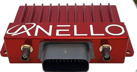
Powered by ANELLO’s optical gyroscope technology and artificial intelligence-based sensor fusion engine, the ANELLO GNSS INS delivers robust, high-accuracy positioning and orientation for applications such as agriculture, construction, trucking, and autonomous vehicles.
The ANELLO GNSS INS comes equipped with unaided heading drift of less than 0.5°/hr, dual multi-band real-time kinematic capable GNSS engines, ASIL-D ready automotive qualified CPU, automotive 2-wire Ethernet, and dual high-speed CAN FD interfaces.
It also features dual RS-232 interfaces, hardware precision time protocol, IEEE 802.1AS. The ANELLO GNSS INS is IP68 waterproof, as well as resistant to dust, salt spray and chemicals.
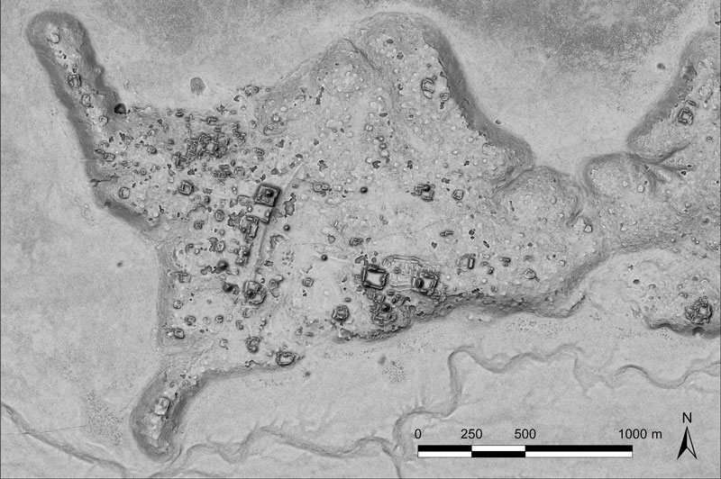
A relief of the ancient Maya site archaeologists are calling Ocomtún. (Image: Žiga Kokalj/ZRC SAZU)
In a biological preserve in Mexico’s Campeche State, a team of archaeologists have documented pyramids, palaces, a ball court and other remains of an ancient city they call Ocomtún, reported the New York Times.
Archeologists surveyed the site for six weeks in May and June, finding 50-foot-tall (15.2-meter-tall) structures resembling pyramids, as well as pottery and Mayan engravings they believe date to between 600 and 900 AD. The team determined the city was likely abandoned more than 1,000 years ago.
Mexico’s National Institute of Anthropology and History (INAH) hailed their findings late last month, saying they discovered the ancient city in “a vast area practically unknown to archaeology.”
“I’m often asked why nobody has come there, and I say, ‘Well, probably because you need to be a little nuts to go there,” said Ivan Sprajc, the survey’s lead archaeologist and a professor at a Slovenian research center, ZRC SAZU. “It’s not an easy job.”
Surveying the area has been revolutionized over the last decade by lidar — allowing researchers to survey densely forested areas that are difficult to explore on foot. Archeologists were able to use airborne lasers to pierce through dense vegetation and reveal the ancient structures and human-modified landscapes beneath.
INAH described the site as having once been a major center of Mayan life. Surrounded by wetlands, Ocomtún includes pyramids, plazas, elite residences and “strange” complexes of structures arranged almost in concentric circles, Dr. Sprajc told CNN.
“For example, we have several very curious architecture complexes of structures which are arranged in almost concentric circles. So, we are only guessing what this could be. Perhaps marketplaces,” he added.
Mexico’s National Institute of Anthropology and Historyteam plans to return next year for further investigation.
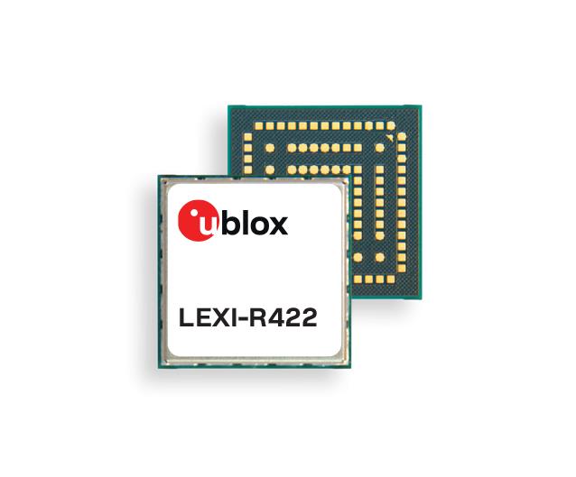
u-blox has released the LEXI-R4, a module customized for size-constrained application requirements. The device is suitable for small asset trackers, such as pet and personal trackers, micro-mobility devices, and luggage tags.
Image: u-blox
The LEXI-R4 module supports all LTE-M and NB-internet of things (IoT) bands, with an RF output power of 23 dBm. It is natively designed to support GNSS AT commands, and its dedicated port enables easy integration with any u-blox M10-based GNSS module, such as the MIA-M10.
Additionally, the module can connect to additional positioning services, such as AssistNow and CellLocate.
The compact size of the module, measuring 16 mm x 16 mm, results from a 40% footprint reduction in dimensions compared to the previous u-blox SARA-R4. Due to its small size, remaining space could host larger antennas, which can improve RF performance, or accommodate larger-size batteries.
Another feature of the LEXI-R4 is its 2G fallback capability. Whenever LTE-M/NB-IoT coverage conditions are not optimal, it continues to function by falling back onto a 2G network. The company said this feature could be helpful in countries where LTE-M/NB-IoT networks have yet to be fully deployed.
“Seen & Heard” is a monthly feature of GPS World magazine, traveling the world to capture interesting and unusual news stories involving the GNSS/PNT industry.
Bikes get tricked out
Image: Snik Bike
Snik Bike is a new app-paired tracking device designed to help users track their bikes if they are lost or stolen, reported North Shore News. Snik Bike Security Co-founder Fraser Vaage developed Snik Bike after having two of his bikes stolen. Snik equips any bike with a rechargeable location device that can be installed in five minutes or less. After pairing the device, the bike is automatically registered with Project 529, which is an online bike registration service. Vaage emphasized that while this device is not a ride-tracking software, such as Strava, it acts as an odometer, tracking overall mileage. The battery is only activated when a bike is stolen, Vaage said, therefore, it’s unlikely Snik will run out of battery. However, if it does, the device diverts to AirTag technology as a backup.
Lighthouses no more
Image: Wiltser/E+/Getty Images
With the wide adoption of GNSS, lighthouses on U.S. shorelines are no longer needed for navigation. To preserve these properties, the General Services Administration has been transferring ownership of the lighthouses to anyone willing to preserve them, reported The Guardian. This year, six lighthouses are being offered to federal, state or local government agencies, non-profits, educational organizations or anyone willing to make them publicly available for educational, cultural, or recreational purposes.
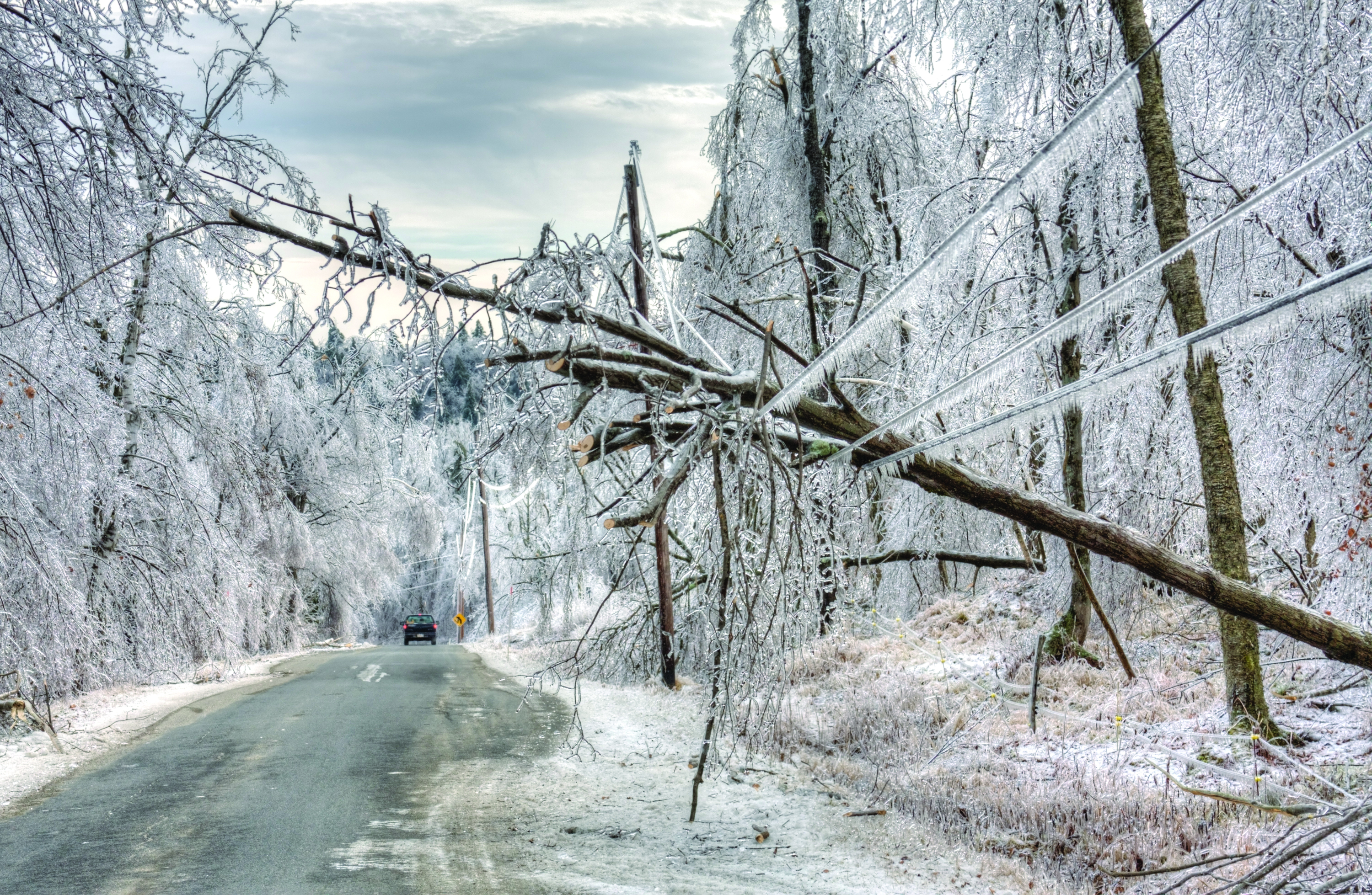
Location data ad weather resiliency
Image: DenisTangneyJr/E+/Getty Images
A Southern Methodist University research team, led by Nicos Markris, measured Dallas’ resilience by recording anonymous cell phone location data among residents in the Dallas metroplex before, during, and after the February 2021 North American winter storm. Measuring a city’s resilience is critical for planning responses to future events and uncovering potential vulnerabilities. By averaging location data, Makris and his team outlined the movement patterns of Dallas residents during a typical week. They compared the normal movement patterns to those during and after the week of the winter storm to determine when Dallas started getting back to normal.
GPS mitigates natural disasters
Image: Philip Thurston/E+/Getty Images
NASA’s Jet Propulsion Lab (JPL) is testing new ways to detect tsunami-like ocean waves before they cause catastrophic damage. The GNSS Upper Atmospheric Real-Time Disaster Information and Alert Network (GUARDIAN) is a new experimental monitoring system that can use data from clusters of GPS and other satellites to detect deadly waves triggered on Earth. Radio signals from GNSS are examined by scientific ground stations around the world. That data is then reviewed by the JPL’s Global Differential GPS network to help mitigate disasters. The GUARDIAN is still evolving and may be used in the future to develop early warning strategies, according to the United Nations’ International Committee on GNSS.
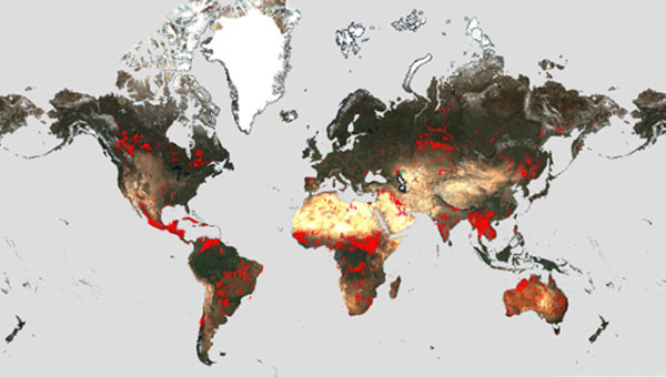
Wildfires have recently spread across Greece, Italy, Spain, Portugal, Algeria, Tunisia and Canada, causing mass environmental and economic damage as well as human casualties. Scientists have warned that wildfires are becoming more frequent and more widespread.
In response, an upgraded version of the World Fire Atlas from the European Space Agency (ESA) is now available. The atlas provides a detailed analysis and map of wildfires across the globe.
Rising global temperatures and the increased extreme weather has led to a surge in the number of wildfires rapidly consuming extensive areas of vegetation and forested lands.
Considering the severe wildfires, ESA has reopened its World Fire Atlas which offers an insight into the distribution of individual fires taking place at a global scale.
Through its interactive dashboard, users can compare the frequency of fires between countries as well as analyze the evolution of each wildfire taking place over time. The atlas was first available in 2019 and it supported both European civil protection agencies and firefighters.
The dashboard uses night-time data from the sea and land surface temperature radiometer (SLSTR) on board the Copernicus Sentinel-3A satellite. Working like a thermometer in the sky, the sensor measures thermal infrared radiation to take the temperature of Earth’s land surfaces which is used to detect the fires.
Data from the Copernicus Sentinel-3B satellite will be added to the atlas in December.
Over the previous seven years, data from the World Fire Atlas show a substantial number of fires detected in Portugal, Italy, Greece, France and Spain.
Data also shows that Canada has experienced 11,598 fires during the first seven months of this year alone. This is a 705% increase compared to fires detected over the same period of the previous six years. Canada is currently battling the country’s worst wildfire season on record, with more than 10 million ha of land burned, which is said to increase in the coming weeks.
The Japan Meteorological Agency (JMA) has reported that on July 10-17, data from GNSS signals indicated continuing minor inflation at shallow depths beneath Mount Ioyama, located on the northwest flank of the Karakuni-dake stratovolcano in the Kirishimayama volcano group in Japan.
Shallow volcanic earthquakes were recorded and vigorous fumarolic activity was visible at the fumarolic on the south side of Mount Ioyama. The alert level remained at two, on a five-level scale, and the public was warned to stay 1 km away from Mount Ioyama.
This JMA report was noted on July 18 in the Weekly Volcanic Activity Report, which is a cooperative project between the Smithsonian Institution’s Global Volcanism Program and the Volcano Hazards Program of the U.S. Geological Survey. The report is updated every Wednesday and averages 16 reported volcanoes.
Innoviz Technologies, a lidar technology company, and the BMW Group, a manufacturer of vehicles and motorcycles, have collaborated on a B-sample development phase for a new-generation of lidar. Under the development agreement, Innoviz will develop the B-samples based on its second-generation InnovizTwo lidar sensor to enable Level 3 automated driving capabilities.
“Lidar is one of the critical technologies underpinning Level 3 or even higher automated functions,” Nicolai Martin, BMW Group’s SVP of driving experience, said. “Optimizing lidar technologies and costs are the major challenges in order to bring Level 3 highly automated driving into the mainstream.”
The companies already have been working together for a few years on an existing program that includes the first deployment of lidar-enabled highly automated technology on the BMW 7 Series, which will launch later this year.
In addition to the lidar solution for the BMW 7 Series, the BMW Group and Innoviz have started the first phase of development for a lidar-based minimal risk maneuver system (MRM). The MRM acts as a secondary safety driving decision platform that will leverage the InnovizTwo lidar sensor to manage real-time driving decisions.
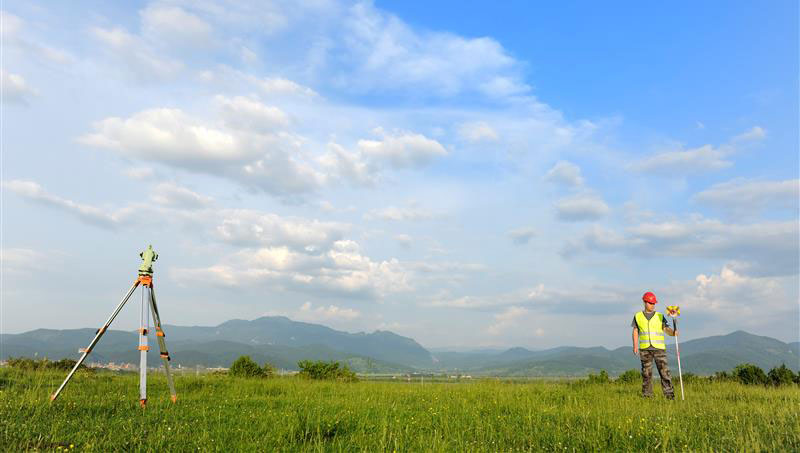
Anyone keeping up with my columns may know that I have been highlighting the geodesy crisis and programs that advance the science of geodesy (July 2020, November 2022, December 2022, and March 2023). On June 13-15, I had the privilege of participating in a working group event convened by the Geomatics Emerging Scientist Consortium for Education, Research and Capabilities Enhancement (GEO-ESCON). The GEO-ESCON, established in the summer of 2022, is a multi-university consortium serving the need of the Office of Geomatics of the National Geospatial-Intelligence Agency (NGA) for personnel with advanced geomatics expertise, a sustainable pipeline of critical geomatics skillsets, and capabilities enhancement in geomatics and other applied sciences. The 15-member consortium is led by The Ohio State University (OSU), which serves as GEO-ESCON’s managing higher education partner.
GEO-ESCON is part of OSU’s Battelle Center for Science, Engineering and Public Policy in the John Glenn College of Public Affairs. As stated in an OSU press release, OSU was selected for its role with GEO-ESCON because of its longstanding commitment to geodetic education — its collegiate geodetic program is the oldest in the United States and offers undergraduate and graduate degrees in both geodetic engineering and geodetic science.
OSU is home to more than 80 researchers across six colleges who focus on core research and development aspects of geospatial science and technology, including geodesy, remote sensing, photogrammetry, GIS, positioning, navigation, and timing (PNT), computer vision, mobility, smart cities, data analytics, autonomous systems (UAS, UUS and UGV), medical imaging, and precision agriculture.
The GEO-ESCON consortium is designed to create a geographically distributed, multi-disciplinary network of universities to educate the federal geomatics workforce at advanced levels and provide opportunities for applied research and technology development. Higher education institutions are invited to participate in GEO-ESCON based on their capabilities in geomatics. As of July 18, the consortium has 15 members and two additional universities are in the process of becoming members. Click here for all GEO-ESCON member institutions.
GEO-ESCON convened the June Geomatics Challenge Working Group to discuss pressing geomatics challenges and discuss potential solutions. The event facilitated dialogue between representatives from NGA’s Office of Geomatics and academic attendees on geomatics challenges of national priority that could result in actionable proposals to address the challenges. The working group enables representatives of GEO-ESCON member institutions to gain a deeper understanding of NGA’s geomatics priorities, build relationships with NGA leaders, collaborate with colleagues at other institutions, and provide recommendations to GEO-ESCON and the NGA. There were 47 academic participants representing 14 universities.
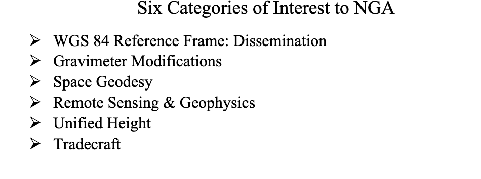
NGA aims to encourage institutions with varied expertise to propose solutions that achieve greater outcomes through collaborative work. The agency provided six broad categories of geomatics challenges for discussion. See the image below for the categories of interest.
Proposals submitted in response to the June Geomatics Challenges Request for Proposals (RFP) will be eligible for funding consideration and selected activities are expected to be awarded before the fall semester.
The word “tradecraft” in the categories of interest was intriguing. In general, tradecraft refers to the skills, techniques, and practices used by professionals in various fields to carry out their work effectively and discreetly. During World War II, however, the term became associated with spy work and now is mostly used to refer to the techniques and procedures of espionage. NGA is concerned with the dramatic drop in the number of individuals pursuing careers in geodesy — that is, the geodesy crisis in the United States.
Event attendees were asked to prioritize the topic(s) that most interested them, so that they could join a small group on the topic to identify issues, and discuss approaches, solutions, and potential actions for the challenge. Several universities had multiple representatives, so they selected different topics aligned with their individual interest.
The meeting had professional workshop facilitators, technical advisors, NGA subject matter experts (SME), and student recorders. Facilitators encouraged the full participation of all attendees to elicit a range of viewpoints and generate previously unconsidered solutions that could bridge differences in approach — resulting in solutions that were supported by many.
The small groups aligned with a specific challenge utilized the expertise of technical advisors — experts in geomatics or related fields with considerable industry, government, and/or research experience — who supported the development and maturation of proposed Geomatics Challenge solutions. The role of technical advisors was to work with the other leaders in their small group to encourage the full participation of all attendees and mentor the groups toward the generation of novel solutions. I was a technical advisor for the “unified height” topic.
NGA’s SME participated in the working group activities and provided additional context for the individual topics, and other unclassified details related to the Geomatics Challenges.
To capture the discussions at the group meetings, student recorders took detailed notes during the small group discussions. The recorders were graduate students — primarily in geodesy or other STEM fields — and they did an excellent job of capturing the discussion, action items, and potential proposals.
As previously stated, individuals self-selected the topic that interested them but over the course of the three-day meeting individuals were asked to participate in other Geomatics Challenge small groups to provide constructive critiques to produce the best research projects. This was an excellent concept that, in my opinion, helped to improve draft proposals and identify new collaborative projects.
As an example, the need for a unified height system that defines, assesses and correlates all height measurement processes became very evident when individuals participating in the “remote sensing and geophysics” topic engaged with the “unified height” topic members. This joint-topic group meeting helped form new partnerships and formulate new proposals.
The GEO-ESCON and the participating institutions have an ambitious schedule of submitting and awarding the grant proposals before the end of the government’s fiscal year. That said, the participants appeared to be up to the challenge and prepared to make it happen. For obvious reasons, I cannot describe any of the projects discussed, but I will highlight them when they become available for public distribution.
For now, I would like to state that GEO-ESCON is a great program, and it supports the advancement of the science of geodesy and geomatics. I believe that integrated and collaborative organizations are necessary for the successful development of geospatial products and services, and GEO-ESCON is the epitome of this concept. If you believe your institution would benefit from joining this consortium, I encourage you to visit their website to learn more or reach out directly to GEO-ESCON’s team ([email protected]). Click here to subscribe and stay up to date on GEO-ESCON news.
In conclusion, as in my previous column, I would like to remind everyone that geodesy is the foundation for all geospatial products and services.
NextNav has successfully tested its positioning and timing solution that combines the company’s assured position, navigation and timing (PNT) TerraPoiNT system with existing LTE and 5G network signals. The test, which took place in San Jose, California, demonstrated how TerraPoiNT signals can be integrated with existing cellular signals to deliver accurate 3D positioning and timing information that is not reliant on GPS and GNSS signals.
Using dedicated terrestrial transmitters and LTE/5G signals, NextNav’s system delivers accurate and reliable 3D positioning and timing information and can augment or complement GPS in places where GPS signals may not be available. Integrating TerraPoiNT with LTE and 5G signals provides a rapid and cost-effective approach to scaling resilient PNT solutions in GPS-denied environments.
“Whether its utilities, banks, data centers, transportation, or emergency services, critical infrastructure today is reliant on GPS for position, navigation and timing services, making it highly vulnerable to GPS as a single point of failure” said Ganesh Pattabiraman, co-founder and CEO of NextNav. “With this integration, we have demonstrated a highly scalable and lower cost alternative — a 3D PNT solution which overcomes the vulnerabilities of GPS with a complementary ground-based resilient PNT layer that extends PNT capabilities in urban and indoor environments.”