Category: Applications

  • Mapping rights-of-way subject of July 13 virtual conference

    Mapping rights-of-way subject of July 13 virtual conference

    Photo: Jordanlye/iStock/Getty Images Plu/Getty Images
    Photo: Jordanlye/iStock/Getty Images Plu/Getty Images

    The 2021 Right-of-Way Asset Mapping Exchange is an interactive online Virtual Conference Experience focusing on innovation in asset inventory and mapping that supports all phases of infrastructure lifecycles. It takes place July 13 and is free of charge.

    The event provides hands-on actionable information on a variety of current and emerging technologies. Via presentations, discussions and one-on-one meetings, the event gives those who attend an opportunity to learn from and engage with technology and experts in a wide range of disciplines, and some of their key clients, as well as peers and colleagues.

    Moderator of the event is Matteo Luccio, GPS World editor in chief. Speakers include:

    Why ROW Asset Mapping?

    ​Right-of-way (ROW) corridors, especially in urban areas, are densely populated by many public and private infrastructure features — overhead electric and telephone wires, street-level parking meters, signage, traffic sensors, underground fiber-optic cables, water mains, natural gas pipes and sewers. They are constantly changing environments, as additional poles, signs and conduits are installed and old ones are replaced with newer ones to restore service after storm damage.

    Yet public works and utility managers, engineers and planners need to know what each stretch of each ROW corridor contains at any given moment, especially as they work to make our cities “smarter.” Hence, the Sisyphean task of mapping these assets.

    Fortunately, the technology to map ROW assets is rapidly improving. Platforms for data collection include vehicles driving at normal traffic speeds, UAVs and manned aircraft. Sensors include digital cameras, lidar scanners and ground-penetrating radar.

    Visualization tools include augmented reality, virtual reality, mixed reality and models ranging from small 2D and 3D ones of individual features up to digital twins of buildings and, eventually, entire cities. Increasingly, the tedious work of identifying and classifying features is being delegated to automated feature extraction software, a form of artificial intelligence.

    The conference will discuss

    • Comparing 2D and 3D visualization tools.
    • Explaining the benefits of 3D models as an advanced spatial analysis tool for urban planning.
    • Exploring the future of smart cities and digital twins.
    • A light equity study and pole inventory in the context of the transition to LED lighting.
    • How a two-man team can capture 500 miles worth of utility data in two weeks.

    Registration is free.

  • 1Spatial updates 1Integrate and 1Data Gateway for geospatial workflows

    1Spatial updates 1Integrate and 1Data Gateway for geospatial workflows

    1Spatial logo1Spatial is making complex workflows easier to manage with the latest releases of its core products 1Integrate and 1Data Gateway. 1Spatial is a global geospatial software and solutions company.

    1Data Gateway 2.4 now has an extended REST API enabling automated submission of data from other applications, while maintaining access control and security of the data supply chain. Submission metadata can be passed back into 1Integrate sessions for downstream processes and analysis. 1Integrate 2.10 can also be configured to “fast-track” certain sessions onto higher priority engines, ensuring important submissions are not left queuing behind other routine jobs.

    “Even though 1Data Gateway is primarily a user portal to our rules engine, the addition of the Submission API will allow our customers to integrate the power of 1Data Gateway into automated workflows and access the rich statistical data collected from the submissions,” said Ricardo Cifres, 1Data Gateway product manager.

    UK Contract Awarded

    Following a competitive tender and in collaboration with Version 1, a global IT services and solutions company, has signed a multiyear contract with the United Kingdom Department of Environment, Food and Rural Affairs (DEFRA) to provide a managed service for the Rural Payments Agency’s (RPA) Rural Payments Service and Land Management System (LMS).

    The contract will provide a recurring managed service enabling DEFRA and the Rural Payments Agency to deliver its current Basic Payment and Countryside Stewardship Schemes. In addition, the new contract enables 1Spatial and Version 1 to support RPA and DEFRA through Agricultural Transition.

    1Spatial has worked with RPA over the past five years to support and develop its Land Management System, an ecosystem of IT components, processes and data, including 1Integrate software. The LMS is RPA’s key control system used as a remote-sensing monitoring tool and to master the land registration data used for subsidy-scheme validation and agricultural policy implementation.

  • New version of OxTS Georeferencer provides more lidar integration

    New version of OxTS Georeferencer provides more lidar integration

    Oxford Technical Solutions (OxTS) has launched the latest version of its lidar georeferencing software, OxTS Georeferencer 1.4.

    OxTS is taking steps to improve surveyor’s user experience, streamline survey processes, and allow surveyors to get to work faster, while simultaneously improving results.

    OxTS Georeferencer fuses position, navigation and timing (PNT) data from an OxTS inertial navigation system (INS) with raw lidar data to output highly accurate 3D point clouds. The software uniquely makes use of navigation diagnostic data that provides surveyors with lidar point-error estimation. This error estimation allows surveyors to focus their analysis on viewing parts of their survey based on estimated errors in points, helping them understand if there are any parts of a survey that need to be looked at again.

    Rather than relying on surveyors to integrate their chosen lidar sensors themselves, OxTS has pre-integrated a number of sensors natively. Previous versions of OxTS Georeferencer integrated widely used sensors from Velodyne, Ouster and Hesai. The pre-existing integrations allow surveyors to focus on surveying rather than ensuring the two datasets work in tandem.

    An optional boresight calibration tool uses data to calibrate the angles between the navigation and survey devices.

    Highlights of OxTS Georeferencer 1.4

    Version 1.4 of OxTS Georeferencer integrates new lidar sensors from Hesai. A previous version released in November 2020 was the first integration of the Pandar40P Hesai lidar. Now, seven new Hesai sensors are being integrated:

    • Pandar40 (beta)
    • Pandar40M (beta)
    • Pandar64 (beta)
    • PandarQT (beta)
    • Pandar128 (beta)
    • PandarXT-16 (beta)
    • PandarXT-32 (tested)

    OxTS Georeferencer 1.4 also features several new developments to enhance the user experience and make it more intuitive.

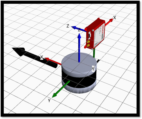
    3D Hardware Setup Viewer. To help input the correct relative rotation angles, specific lidar models will be available to view depending on the surveyor’s choice of lidar. The model will represent the lidar sensor in appearance, size and orientation within OxTS Georeferencer with respect to the OxTS INS for quick and intuitive configuration.

    The OxTS Georeferencer Hardware setup viewer shows the OxTS xNAV650 INS alongside a Hesai lidar sensor. (Image: OxTS)
    The OxTS Georeferencer Hardware setup viewer shows the OxTS xNAV650 INS alongside a Hesai lidar sensor. (Image: OxTS)

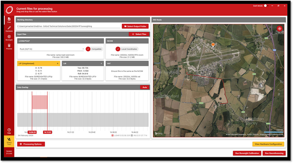
    Time overlap chart. Georeferencer 1.4 reintroduces a time overlap chart that allows surveyors to visualize their survey route on a map and select specific start and end times. This enables surveyors to control the part of the route they would like to view, with the added ability to georeference only that section of the survey.

    The OxTS Georeferencer time overlap chart. (Image: OxTS)
    The OxTS Georeferencer time overlap chart. (Image: OxTS)

    Lidar CAD models will make it easier for surveyors to calculate and input accurate LIR angles into OxTS Georeferencer, further streamlining the survey process.

    The time overlap function will provide surveyors with even more flexibility — this time after the survey. Giving surveyors the ability to choose the start and end times of their survey, and therefore which part of the survey to georeference, enables full control of what to present to their peers.

    These new features, coupled with those already present in OxTS Georeferencer (optional boresight calibration and point uncertainty analysis) give surveyors the flexibility and control they need to produce the best possible lidar surveys.

  • ESA seeks ideas to augment satnav with imaging sensors, 3D maps

    ESA seeks ideas to augment satnav with imaging sensors, 3D maps

    NAVISP includes projects for autonomous and connected driving. (Image: ESA/F. Bagiana)
    NAVISP includes projects for autonomous and connected driving. (Image: ESA/F. Bagiana)

    The European Space Agency (ESA) is issuing a call for ideas to overcome GNSS service gaps in urban canyons by using imaging and 3D mapping technology. A workshop to discuss the call for ideas will be held virtually on July 6.

    According to ESA, the growing availability of high-quality image sensors and high-fidelity 3D maps — such as those within smartphone mapping apps — offer a promising way to shrink the performance gap caused by urban canyons and multipath for future mobility applications in terms of ubiquity, reliability and resilience.

    NAVISP — ESA’s Navigation Innovation and Support Programme — specifically is seeking prospects for technology demonstrations of mobility tech to support applications such as  road, maritime transport and drones. The tech would provide assisted satnav by harnessing image sensors and 3D urban models. The proof-of-concept demonstration projects or national testbeds would facilitate introduction of this technology into commercial products.

    Use cases include private or public autonomous transportation in cities, including cars, trams, scooters, bikes, urban ferries, harbors, narrow waterway navigation and future passenger drones.

    Reflected satellite navigation signals (multipath) can degrade positioning performance, especially in urban canyons with numerous artificial surfaces. (Image: EUSPA)
    Reflected satellite navigation signals (multipath) can degrade positioning performance, especially in urban canyons with numerous artificial surfaces. (Image: EUSPA)

    The NAVISP project, called a “thematic window,” is titled “Assisted GNSS with Imaging Sensors and 3-D models for Mobility Applications.” The thematic window opened on June 10 and will close on Oct. 31. During its duration, ESA is offering dedicated support to companies interested in participating in the projects and submitting outline proposals.

    On July 6, the agency is hosting an online workshop with stakeholders to raise awareness about the initiative and clarify any issues interested companies may have. ESA will present the requirements of the Thematic Window and the application process. The workshop will include presentations from high-level experts covering market perspectives, techniques involved in the use of 3D models and imaging sensors, the state of the art of these technologies and latest advances in visual navigation and artificial intelligence applied to mobility applications.

    To register for the July 6 workshop, click here. The workshop agenda is available here.

  • GAO Report checks defense on PNT tech

    GAO Report checks defense on PNT tech

    Cover: USGAO Report
    Download the GAO Report.

    A May report by the Government Accountability Office (GAO) explores Department of Defense (DOD) strategy for positioning, navigation and timing (PNT) technology to complement GPS. The 51-page report takes a comprehensive view of alternative PNT policy and leadership across the department.

    While GPS will remain the core of DOD’s PNT solution, it will use other PNT technology to complement GPS or as an alternative for when GPS is degraded or unavailable. DOD is exploring both improved sensors to provide relative PNT information, and external sources to provide absolute positioning and navigation.

    DOD also is working to create common standards and interfaces to help integrate and field new PNT technologies faster and at lower cost. DOD also is developing its PNT modeling and simulation capabilities to evaluate the performance of new PNT technologies.

    Challenges for DOD

    Officials from across DOD and experts told GAO that alternative PNT solutions are not prioritized within DOD. For example, there is no central program office responsible for developing the variety of alternative PNT technologies across DOD.

    DOD’s continued reliance on GPS, despite known GPS vulnerabilities to disruption, presents a challenge for obtaining sufficient support to develop viable alternatives. Defense officials and experts also said challenges in establishing clear PNT performance requirements hinder technology development.

    In response, GAO developed six policy options that may help address challenges with developing and integrating alternative PNT technologies. The policy options identify possible actions by policymakers, who may include Congress, federal agencies and industry groups.

    1. Increase collaboration. Consider mechanisms to coordinate across DOD to clarify responsibilities and authorities in prioritizing the need for alternative PNT technologies.
    2. Focus on resiliency. Consider selecting the most resilient technologies as the cornerstone of the PNT suite for military missions, rather than defaulting to GPS.
    3. Clarify requirements. Consider opportunities to clarify what level of PNT performance actually is needed for missions, rather than defaulting to requirements that match GPS performance.
    4. Coordinate with industry. Consider ensuring DOD and industry coordinate so that industry is prepared to meet DOD’s needs, and DOD can leverage industry advances.
    5. Institutionalize open architecture. Consider making the open architecture initiative more permanent, including providing funding.
    6. Analyze vulnerabilities. Consider having DOD conduct ongoing analysis of vulnerabilities of different PNT systems.

    The GAO reviewed technical studies, agency documents, and other key reports; interviewed government officials and researchers about alternative PNT technologies; and convened a three-day meeting of experts from government, non-governmental organizations, academia and industry.

  • GPS III SV-05 encapsulated ahead of June 17 launch

    GPS III SV-05 encapsulated ahead of June 17 launch

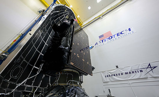
    The fifth GPS III satellite was encapsulated within a SpaceX payload fairing on June 9 in preparation for its June 17 launch.

    The U.S. Space Force’s Space and Missile Systems Center’s Lockheed Martin-built GPS III Space Vehicle 05 satellite was encapsulated within a SpaceX payload fairing at Astrotech Space Operations Florida facility on June 9 in preparation for launch, scheduled for June 17 from Cape Canaveral Space Force Station.

    The 15-minute launch window opens 12:09 p.m. EDT. If SpaceX provides a live feed to view the launch, it will be available here.

    Encapsulation of the satellite within the payload fairing protects the satellite from the impact of dynamic pressure and aerodynamic heating during its harrowing journey through the earth’s atmosphere, and supports the ability to communicate with the satellite until separation from the launch vehicle on orbit.

    “The GPS III program continues to make strides in modernizing the GPS constellation for the United States Space Force, maintaining the ‘gold standard’ for position, navigation and timing,” said Col. Edward Byrne, Medium Earth Orbit Space Systems division chief, “SV05 is not only the first-ever USSF satellite launched on a previously flown booster, but also is the 24th military-code (M-xode) satellite introduced to our constellation, the last needed to bring M-code to full operational capability.”

    GPS III SV05 will join the current 31-satellite operational constellation to continue to provide the gold standard in positioning, navigation and timing services for more than four billion users worldwide.

    The Space and Missile Systems Center, located at Los Angeles Air Force Base in El Segundo, California, is the U.S. Space Force’s center of acquisition excellence for acquiring and developing military space systems. Its portfolio includes the development of advanced space and launch capability and systems, global navigation satellite systems, military satellite communications, defense meteorological satellites, space launch and range systems, satellite control networks, space-based infrared systems, and space situational awareness capabilities.

    GPS III SV05 is encapsulated within a SpaceX payload fairing at Astrotech Space Operations Florida in preparation for its June 17 launch. (Photo: Lockheed Martin)
    GPS III SV05 is encapsulated within a SpaceX payload fairing at Astrotech Space Operations Florida in preparation for its June 17 launch. (Photo: Lockheed Martin)


  • NextNav goes public with Spartacus Acquisition Corp.

    NextNav goes public with Spartacus Acquisition Corp.

    NextNav logoGPS company NextNav and Spartacus Acquisition Corp, a special-purpose acquisition company, has entered into a definitive merger agreement that will result in NextNav becoming a public company. The combined company will be named NextNav Inc. Its common stock and warrants will be listed on the Nasdaq under the ticker symbol “NN” and “NNW”, respectively.

    Gross proceeds of up to $408 million from the business combination are expected to be used to fuel growth in its current businesses, continue to build NextNav’s next-generation GPS platform, expand products (one of which is already deployed in 4,400 cities), and to expand its land-based radio positioning and timing network.

    The NextNav platform serves a $100 billion global total addressable market in public safety, E911, mass-market consumer apps, eVTOLs, UAVs and autonomous vehicles, internet of things (IoT), critical infrastructure and other sectors. Beyond its technology and intellectual property, NextNav owns a portfolio of nationwide spectrum licenses for 2.4 billion MHz-PoPs of 900 MHz spectrum.

    Gary Parsons, former chairman of the board of Sirius XM Radio, has served as chairman of NextNav’s board of directors for the past 10 years and will continue in that role. Peter Aquino, chairman of the board and CEO of Spartacus, will also join the NextNav board upon closing of the business combination. Aquino has led several companies through fiber and wireless operations and network deployments, and the development of overlay technologies designed to drive new revenue streams.

    NextNav will continue to be led by Ganesh Pattabiraman, the company’s co-founder, CEO and president. Pattabiraman, who started at Qualcomm, has experience in building scalable location technologies using terrestrial and satellite-based technologies,

    In addition, the full NextNav management team — co-founder Arun Raghupathy, SVP of Engineering; Chris Gates, CFO; and David Knutson, SVP of Network Operations and Deployment — will continue to manage NextNav.

    Hogan Lovells is advising NextNav with corporate and finance partner Randy Segal and partners Adam Brown, John Duke, and Jessica Bisignano leading the team. Senior associates Michael Rogers and Liz Banks, and associate Chelsea Shrader assisted as well.

  • IMCA publishes guidelines on use of GNSS for tide calculations

    Nick Hough, IMCA
    Nick Hough, IMCA

    The International Marine Contractors Association (IMCA) has published “Guidelines on the use of GNSS for tide calculations” (IMCA S 027). It provides an overview of how GNSS can assist in more accurate real-time direct measurement of tidal changes. IMCA S 027 is available for members to download free of charge, and costs £50 for non-members.

    IMCA S 027 includes sections on

    • tide theory
    • geodetic reference systems and tidal datums
    • tides from GNSS
    • quality assurance and quality control
    • glossary, references and a list of further reading

    One reference is the recently revised IMCA S 015, “Guidelines for GNSS positioning in the Oil and Gas industry,” produced with the International Association of Oil and Gas Producers.

    “As with horizontal positioning, vertical positioning is referenced to specified datums,” explained Nick Hough, IMCA’s technical adviser for Offshore Survey. “Unlike land surveying, where vertical measurements (elevations) are made from and to a known, fixed position, vertical measurements offshore (depths) are taken against a moving dynamic surface.”

    “All absolute depths recorded from survey activities need to be adjusted for tide and reduced to a known constant vertical datum such as Mean Sea Level (MSL) or Lowest Astronomical Tide (LAT),” Hough said. “The effect of tides will result in depth differences at different times of the day, and at the same times on different days.”

    “Advances in GNSS technology enable accurate and consistent calculation of height above a known datum, which means reliance on tide gauges or tide prediction tables is no longer necessary,” Hough said.

  • New HxGN Connect enables seamless, citywide collaboration

    New HxGN Connect enables seamless, citywide collaboration

    Hexagon AB has launched HxGN Connect, a software-as-a-service (SaaS) workspace for citywide collaboration enabling government agencies and other organizations to share data and coordinate action for ad-hoc, routine and emergency situations.

    Hosted in Microsoft Azure, HxGN Connect provides a networked workspace and unified view of information within and between entities. Participants can actively collaborate and securely share data as events unfold, overcoming technical and political barriers that result in missed opportunities, conflicting actions, errors and delays.

    With HxGN Connect, organizations can move beyond basic cooperation to true collaboration, where all participants gain mutual value. HxGN Connect is easily implemented and scaled — whether between multiple departments in a single agency or multiple organizations across cities and regions.

    “The future of smart cities lies in connected data communities that enable users to work with people and information irrespective of organizational and geographical affiliations or technology limitations,” said Hexagon President and CEO Ola Rollén. “HxGN Connect reimagines collaboration, breaking down barriers and bridging gaps between vertical sectors, organizational types and operational functions, which means safer cities, more effective services and happier residents.”

    HxGN Connect brings a city’s public safety, transportation, utilities and other related organizations together seamlessly. While users can visualize people, places and activities, and send messages and assign tasks to each other, all participants retain full ownership and control of their own data (nothing is stored in a central repository).

    The HxGN Connect dashboard. (Screenshot: Hexagon AG)
    The HxGN Connect dashboard. (Screenshot: Hexagon AG)
  • Controversial GAO report on DOD nav webinar June 15

    Controversial GAO report on DOD nav webinar June 15

    webinar ad

    On May 10, the Government Accountability Office (GAO) released a report on navigation efforts n the Department of Defense (DOD). Among its findings were that the department regularly fails to establish validated navigation and timing requirements for systems and instead defaults to the capabilities of GPS. Also, that alternate positioning, navigation and timing (PNT) efforts are not prioritized, and sometimes actively opposed, by forces within DOD.

    One of the report’s more startling recommendations is that the department change its focus from GPS as the central pillar of its PNT strategy going forward in favor of resilient technologies.

    The Institute of Navigation (ION) and Resilient Navigation and Timing Foundation (RNTF) are hosting a webinar to discuss the report with two of its authors on June 15 at 11 a.m. ET. Two members of the Senate Armed Services Committee staff have also been invited as panelists.

    After a panel discussion moderated by Dana A. Goward, president of the RNT Foundation, attendees will have the opportunity to ask questions of the panelists.

    The event is open to the public, but attendees must register in advance.

  • US Congress may move against Chinese-made drones

    US Congress may move against Chinese-made drones

    The FLIR M440 UAV. (Photo: Teledyne FLIR)
    The FLIR M440 UAV. (Photo: Teledyne FLIR)

    A bill moving through the U.S. Congress would impose a five-year ban on United States government purchases of drones manufactured or assembled in China, reports The Associated Press. The measure reflects bipartisan concerns that the unmanned aerial vehicles (UAVs) made in China could facilitate Chinese spying on critical infrastructure.

    Major commercial and consumer UAV-maker company DJI is based in Shenzhen, China. Many of its small, low-altitude drones are employed by local and regional government users in law enforcement, emergency response and surveying. The ban could affect police departments that rely on federal funds for equipment. In 2020, the Department of Homeland Security halted such grants for Chinese-made drones.

    Chinese-made components, including GNSS receivers and inertial sensors, are not addressed in the bill, and the Pentagon has acknowledged that many components for non-Chinese-company drones are made in China.

    While the ban wouldn’t go into effect until 2023, many federal agencies have already imposed temporary restrictions on the use of Chinese drones. The Interior Department had flown more than 11,000 drone missions before January, when the agency temporarily grounded its fleet of more than 500 DJI drones over cybersecurity concerns, according to The Hill. The Hill cites a May 6 Pentagon report. The report found no malicious code in the software for DJI’s Government Edition drones.

    An analysis by Booz Allen Hamilton released in June 2020 found no evidence that DJI drones have shared sensitive information with the company or the Chinese Communist Party.

    In August 2020, the Defense Department issued approval to drones from five companies:

    • Skydio’s X2-D. Skydio is based in Redwood City, California.
    • Parrot’s Anafi USA. While Parrot is based in Paris, France, the ANAFI USA drone is manufactured in the United States for U.S. customers.
    • Teledyne FLIR’s Flir M440 Ion. The drone was originally made by Altavian in Florida, which was acquired by FLIR in December 2020, which was subsequently acquired by Teledyne Technologies in January. Teledyne FLIR is headquartered in Wilsonville, Oregon.
    • Teal Drones’ Golden Eagle. Teal Drones is based in Salt Lake City, Utah.
    • Vantage Robotics’ Vesper. Vantage is based in San Leandro, California.

  • TRX Systems delivers NAVWAR threat mapping for foot soldiers

    TRX Systems delivers NAVWAR threat mapping for foot soldiers

    Image: TDK/U.S. Army
    Image: TDK/U.S. Army

    Electronic Warfare Kit enables dismounted soldiers to detect, map and mitigate the impact of navigational warfare (NAVWAR) attacks

    TRX Systems, developer of NEON GPS-denied location solutions, has delivered the TRX Systems Dismount Electronic Warfare (EW) Kit prototype to the U.S. Army.

    Developed for U.S. Army Rapid Capabilities and Critical Technologies Office (RCCTO), the TRX EW Kit is designed to extend EW and signal intelligence for the dismounted warfighter.

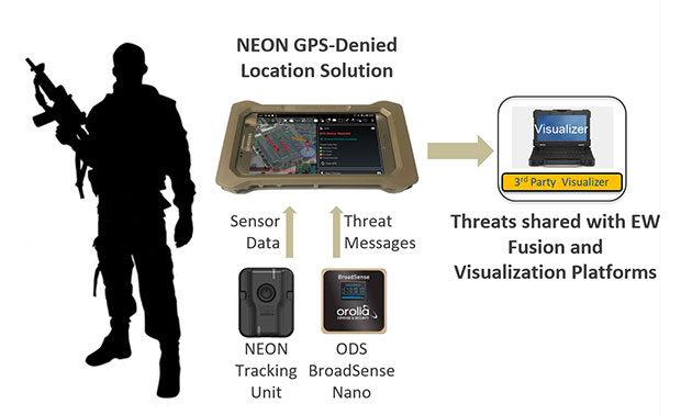
    The kit adds powerful new capabilities to the company’s NEON Personnel Tracker-MIL solution, expanding the integration between its NEON Location Service and ATAK application to better equip dismounted personnel for detection and mapping of jamming and spoofing attacks.

    New NEON functionality includes:

    • Robust Interference Detection. Rapidly detects and geo-references NAVWAR threats including GPS jamming, repeating and spoofing.
    • NAVWAR Threat Mapping. Increases situational awareness by geo-referencing and mapping detected threats through integration with ATAK and EW platforms.
    • Reliable Dismount Location Data. Mitigates the impact of NAVWAR attacks by eliminating erroneous GPS inputs while continuing to deliver reliable location data to dismounted users.
    • Integration with NAVWAR Devices. Integrates threat data from Orolia Defense & Security BroadSense Nano and other devices already carried by warfighters to provide a fused NAVWAR threat indication.

    The NEON Personnel Tracker Military (PT-MIL) uses a suite of patented algorithms that fuse GNSS, an inertial sensor, ultra-wideband (UWB) and other inputs to deliver reliable position data to dismounted personnel operating in the presence of compromised or intentionally denied GNSS signals.

    With the new EW Kit functionality, warfighters will receive real-time situational awareness into jamming or spoofing threats at their immediate location and from other dismount personnel sharing data over the TAK network.

    The EW Kit is integrated via soldier plug-ins, enabling threats discovered and mapped by dismounts to be fused into the overall NAVWAR threat picture.

    “In today’s conflict zones, it’s becoming increasingly easy for adversaries to launch electronic attacks against GNSS systems using low-cost jammers built with readily available commercial technology,” said Carol Politi, president and CEO of TRX Systems. “The EW Kit developed in the RCCTO program provides dismount soldiers with clear insight into their NAVWAR environment by rapidly detecting and characterizing these NAVWAR attacks, and it mitigates the impact by eliminating compromised data from their position solution.”