Category: Applications

  • U.S. Air Force’s 2 SOPS performs first GPS III maneuver

    U.S. Air Force’s 2 SOPS performs first GPS III maneuver

    By Airman 1st Class Jonathan Whitely, 50th Space Wing Public Affairs

    News from Schriever Air Force Base

    The 2nd Space Operations Squadron performed the first station keeping maneuver on a GPS III satellite to Satellite Vehicle Number 75 on May 14 at the Schriever Air Force Base in Colorado.

    The maneuver set a new standard for how GPS maneuvers should be conducted for the squadron that provides precision, navigation and timing signals to billions of users around the world.

    A station keeping maneuver is performed to keep vehicles in their node (or parking spots in orbit) and involves burning the satellite’s thrusters and changing the vehicles speed at a particular point in its orbit. This causes the orbit to change, in turn, keeping the vehicle in the ideal position to provide coverage.

    “All operational GPS vehicles are assigned nodes, when all nodes are filled with healthy vehicles there is good global GPS coverage,” said 1st Lt. Michael Gallagher, GPS subsystems analyst. “When new vehicles are launched they typically aren’t launched directly into their final node. This means that the 2 SOPS analysis flight must perform a re-phase maneuver to put a vehicle in its node.”

    The maneuver required GPS III’s signal to be turned off. Turning off the navigation signal while performing the maneuver prevents users from receiving inaccuracies generated by a change in satellite velocity.

    “This was a new process that we could learn from as it was the first station keeping [maneuver] performed for the newest generation of GPS satellites,” said Senior Airman Harrison Sherwood, 2 SOPS satellite systems operator, who sent the commands to the satellite during the maneuver. “[Since] this was the first [maneuver] of the newest generation satellites, it was a bit of a guinea pig for future maneuvers.”
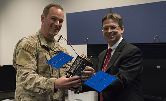
    Johnathon Caldwell, Lockheed Martin Space vice president of navigation systems, right, presents Lt. Col. Stephen Toth, 2nd Space Operations Squadron commander, with a GPS III model satellite as a token of appreciation for the 2nd SOPS critical mission in space at Schriever Air Force Base, Colorado, July 29, 2019. The squadron performed its first station keeping maneuver on a GPS III satellite May 14, 2020, at Schriever AFB. (Photo: U.S. Air Force/1st Class Jonathan Whitely)
    Johnathon Caldwell, Lockheed Martin Space vice president of navigation systems, right, presents Lt. Col. Stephen Toth, 2nd Space Operations Squadron commander, with a GPS III model satellite as a token of appreciation for the 2nd SOPS critical mission in space at Schriever Air Force Base, Colorado, July 29, 2019. The squadron performed its first station keeping maneuver on a GPS III satellite May 14, 2020, at Schriever AFB. (Photo: U.S. Air Force/1st Class Jonathan Whitely)

    However, the unit was able to complete the maneuver flawlessly. The maneuver was completed in a special mission area and there were no changes to the normal operations floor.

    “This maneuver had no effect on the rest of the [GPS satellite] constellation,” Gallagher said. “SVN-45 was in the node SVN-75 was being placed into, so there was no decrease in GPS signal quality as a result of this maneuver.”

    This procedure was also the first of its kind to be performed with the 2nd SOPS Architecture Evolution Plan, which all active satellites in the program are operated. Since GPS III vehicles are fully integrated into the program with this maneuver, all maintenance is conducted through AEP.

    “Station keeping maneuvers are essential to satellite operations and must be done for regular maintenance,” said 2nd Lt. Tyler Gorman, 2nd SOPS navigation payload engineer. “This activity helped validate a nominal maintenance activity for a new generation of vehicles.”

    The unit plans to continue to use this new method and program for future GPS satellites that are being launched and need to be re-phased into their operation slots. The next satellite that will need a station maneuver performed is SVN-76, which is scheduled to launch in the next few months.

    “GPS maintenance requires a coordinated effort to ensure our worldwide service is preserved,” Gorman said. “That means careful planning and execution from our analysts in 2 SOPS, our satellite system operator and the operational support from Lockheed Martin and the Aerospace Corporation.”
  • Kaarta launches Stencil Pro mobile mapping system with GNSS alignment

    Kaarta launches Stencil Pro mobile mapping system with GNSS alignment

    SLAM-based mobile mapping with integrated 360° color is a rugged, geo-enabled, high-density and versatile workhorse

    Photo: Kaarta
    Photo: Kaarta

    Kaarta, an innovator of real-time mobile 3D reality capture, has announced beta testing on Stencil Pro, a versatile professional-grade mobile mapping platform with dimensional and visual fidelity.

    According to a Kaarta press release, “Whether on the road or on a job site, in a warehouse or an office, an underground mine or in the woods, along a utility corridor or a railway, the multipurpose Stencil Pro mobile mapping system is ready to take on the most challenging environments with impressive speed, providing accurate and visually stunning results.”

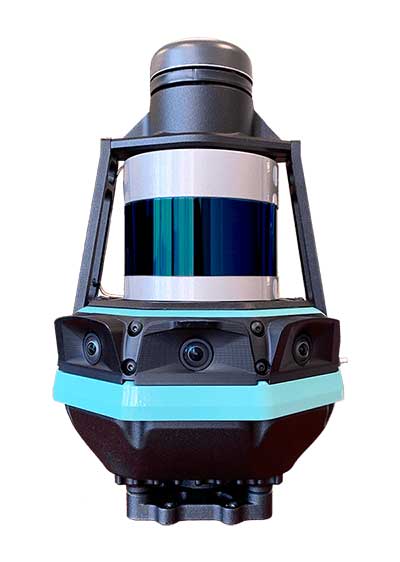
    An all-in-one system to scan, process and view captured data in real time, Stencil Pro offers panoramic high-definition 4K imagery and colorized point clouds. With robust surround-view perception in a wide range of light conditions, Stencil Pro is optimized for both indoor and outdoor performance.

    Featuring a 32-line high-density, low-noise lidar with a range of 120 meters (nearly 400 feet) and a data rate of 600,000 points per second, Stencil Pro produces a highly accurate 3D model in minutes.

    With an IP65 rating, Stencil Pro is safeguarded against adverse elements such as dirt, dust, fog and rain, making it the ideal tool for infrastructure mapping, mining, forestry, earthworks, construction and other harsh environments. Stencil Pro’s rugged and versatile design is adaptable to many environments, capturing data amidst poor weather, dusty work environments, and below-ground cavities or when mounted on vehicles, locomotives, ATVs and other platforms.

    Like all Kaarta systems, Stencil Pro’s simultaneous localization and mapping (SLAM) capabilities means it operates in GNSS-denied areas such as indoor, underground, under canopy, or in urban canyons. However, it is also fully geo-enabled for the many applications such as street, corridor and rail mapping where the addition of a GNSS signal is highly beneficial.

    Stencil Pro integrates the Trimble BD-990 receiver, AV-28 antenna and a range of other third-party GNSS antennas. It supports positioning accuracy enhancements through live RTK/NTRIP processing as well as PPK corrections based on data provided by the NOAA CORS network or a user-supplied base station.

    GNSS positioning data is used to align and geo-register data, providing global accuracy and further enhancing the fidelity of large area scans and long, linear scan paths. With the ruggedized design, enhanced power capabilities, as well as the option of incorporating the industry-leading SLAM accuracy in addition to – or independent of – geopositioning, Stencil Pro has the scale of traditional mobile mappers for a fraction of the investment.

    The onboard GNSS and color cameras are fully integrated into real-time capture, allowing for optimization of collected data as well as flexibility in output. The advantage of absolute positioning and accuracy coupled with 360 degree imaging technologies produces a true color, rich and robust point cloud when needed. If a colorized point cloud is not required, or GNSS is not available, reliance on other sensors is seamless.

    “Billions of dollars of commercial real estate transactions, construction projects, infrastructure maintenance and natural resource management decisions rely on understanding existing conditions data,” said Kevin Dowling, Kaarta CEO. “Obtaining up-to-date data for these environments is laborious, time consuming and expensive with current methods. Even in the most challenging scenarios, Stencil Pro rapidly provides the answers needed for managers to make informed decisions.”

    Stencil Pro is powered by either 100-240 VAC input (or 12V with an inverter) or using its two hot-swappable batteries which last for up to 3 hours of scanning. Stencil Pro’s intuitive user interface makes data capture and processing simple. The user experience includes one-button scanning, real-time scan monitoring and streamlined post-processing options for maximizing data clarity and usability. Remote operation with a touchscreen monitor allows for mounting Stencil Pro on a multitude of transports. When hand-carried, scan status can be started and stopped with the press of a button.

    Stencil Pro is built on Kaarta Engine, Kaarta’s patent-pending approach to solving the SLAM problem. Kaarta’s unparalleled expertise in localization – a result of its deep robotics roots – delivers definitively lower drift error than alternative SLAM systems by an order of magnitude. Kaarta’s proven technology, quality, and accuracy is trusted by AEC, geospatial, natural resource management and autonomous mobile robot professionals worldwide.

    Limited quantities of Stencil Pro will be available to ship in June. Those interested in being considered for early access to discuss a specific application, schedule a demonstration or review sample data sets can apply for the Stencil Pro Early Access Program.

  • CHC Navigation introduces AT661 GNSS geodetic antenna

    CHC Navigation introduces AT661 GNSS geodetic antenna

    Cost-effective, high-performance antenna designed for GNSS networks and monitoring applications

    Photo: CHC Navigation
    Photo: CHC Navigation

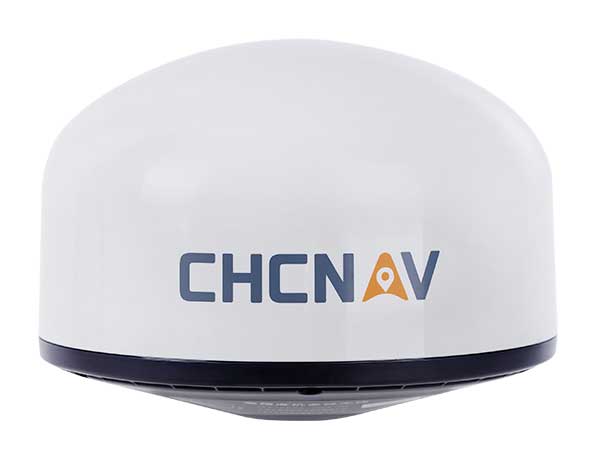
    CHC Navigation has released the AT661 geodetic antenna for GNSS networks or monitoring applications. The AT GNSS antenna series is the result of years of expertise in GNSS technologies. The compact geodetic GNSS antenna offers performances rivaling those of high-cost and bulky conventional GNSS choke ring antennas, according to CHC Navigation.

    The AT661’s supports all current and future GNSS signals, including GPS, GLONASS, BeiDou, Galileo, QZSS, IRNSS, SBAS and L-band. The antenna features both high-gain LNA and wide beamwidth to provide excellent flexibility in applications requiring low-elevation satellite reception and high availability of GNSS signals, especially in obstructed situations.

    “By further integrating the design and manufacture of GNSS antennas, CHC Navigation is broadening its presence as a global provider of GNSS solutions.” said George Zhao, CEO of CHC Navigation. “Mastering the entire GNSS positioning and navigation value chain allows us to deliver the performance our customers demand at the price they expect.”

    The accuracy of the antenna’s phase center reaches the millimeter level with extremely high stability and repeatability to ensure perfect processing of GNSS data regardless of the length of the baselines.

    Built to last, the AT661 withstands all types of weather, including high and low temperature fluctuations, and is protected by a waterproof radome.

  • US Air Force grants Honeywell GPS/INS contract

    Honeywell logo

    Honeywell has been granted a four-year, $99 million contract to help the U.S. Air Force for the embedded GPS and inertial navigation systems (INS) modernization program (EGI-M). Honeywell will provide engineering, manufacturing and development services to the EGI-M program under the sole-source contract, according to the Department of Defense.

    Work will be performed in Clearwater, Florida, through April 19, 2024.

    The contract is the result of a sole-source acquisition and only one offer was received. The Air Force Life Cycle Management Center, Position, Navigation & Timing Contracting Branch, Robins Air Force Base, Georgia, is the contracting activity (FA8576-20-C-0001).

  • NovAtel delivers OEM driver built on Robot Operating System

    NovAtel delivers OEM driver built on Robot Operating System

    Hexagon | NovAtel has released its first purpose-built driver, powered by Robot Operating System (ROS), to support its OEM7 family of GNSS receivers.

    The driver, developed by NovAtel engineers, provides an optimized interface enabling users to accelerate autonomous development projects by quickly incorporating NovAtel OEM7 receivers into custom applications.

    The driver is available for immediate download through the new NovAtel GitHub repository or as a ROS Binary Package for direct installation.

    With the release of a NovAtel-developed OEM7 driver built on ROS, developers can now confidently access the critical data needed to build autonomy algorithms for academic investigations, ride-share programs, and other applications.

    Data from numerous sensors can be combined to help move projects into higher levels of autonomy faster without the need to adapt community-developed drivers. Tested using the Hexagon | AutonomouStuff platform, the driver ensures that the data received accurately reflects the output provided by the receiver, while also giving users the ability to record raw data for post-processing.

    “We are excited to introduce our first purpose-built driver powered by ROS to the GitHub community. Its development is a result of collaboration between NovAtel and AutonomouStuff in support of Hexagon’s Smart Autonomous Mobility (SAM) initiative, unveiled at CES 2020 in Las Vegas,” said Miguel Amor, chief marketing officer, Hexagon’s Autonomy & Positioning division. “The SAM portfolio is a comprehensive solutions platform that brings together all the necessary sensors, software and services to make autonomous driving possible.”

    The new driver is available for download on the NovAtel GitHub repository.

    ROS is a trademark of Open Robotics.

    Hexagon's Smart Solutions portfolio. (Image: Hexagon)
    Hexagon’s Smart Solutions portfolio. (Image: Hexagon)
  • ASPRS Annual Conference at Geo Week 2020 to go virtual because of COVID-19

    ASPRS Annual Conference at Geo Week 2020 to go virtual because of COVID-19

    Logo: ASPRS

    The American Society for Photogrammetry and Remote Sensing (ASPRS): The Imaging and Geospatial Information Society has withdrawn its ASPRS 2020 Annual Conference Virtual Technical Program from the Geo Week 2020 face-to-face event and will be going virtual because of COVID-19.

    Geo Week 2020 is currently scheduled to take place July 27-29 at the McCormick Center in Chicago.

    According to ASPRS, all presenters originally accepted for the March event in Washington, D.C., will have the opportunity to share their work in the ASPRS 2020 Annual Conference Virtual Technical Program, a series of online technical sessions taking place June 22-26.

    Because the ASPRS 2020 Annual Conference Virtual Technical Program is being hosted, organized and managed by ASPRS alone, there will be a new, separate registration process and fee for all presenters and attendees. Existing Geo Week 2020 conference registrations are not transferable to this new ASPRS event, ASPRS said. Registrants may contact [email protected] if they wish to request a refund for all or part of their Geo Week 2020 registration or transfer their 2020 registration to Geo Week 2021.

    Those who register for the ASPRS 2020 Annual Conference Virtual Technical Program will be given access to all of the online technical sessions, as well as live webinars and on-demand recordings, ASPRS said. The full program will e published on the conference website on June 8.

  • Dewberry selected for NOAA shoreline mapping contract

    Dewberry selected for NOAA shoreline mapping contract

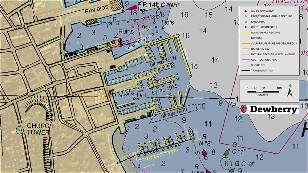
    Existing NOAA nautical chart of Nantucket Harbor, Mass., overlaid with revised shoreline features collected by Dewberry. Image courtesy of Dewberry. (Image: Dewberry/NOAA)
    Existing NOAA nautical chart of Nantucket Harbor, Mass., overlaid with revised shoreline features collected by Dewberry. Image courtesy of Dewberry. (Image: Dewberry/NOAA)

    Dewberry has been selected by the National Oceanic and Atmospheric Administration (NOAA) for the agency’s Shoreline Mapping Services contract. The five-year, indefinite delivery/indefinite quantity (IDIQ) contract has a ceiling of $40 million and will enable Dewberry and its partners to work with NOAA’s National Geodetic Survey to develop new technologies and initiatives to protect the nation’s coasts.

    This is Dewberry’s second consecutive shoreline mapping services contract for NOAA. Over the past five years, the firm completed 30 task orders across the nation, including research studies to analyze bathymetric point tracing, derive bathymetry from satellite data, and apply INSAR data to analyze subsidence.

    Task orders also included shoreline mapping in Alaska; creating topobathymetric lidar and shoreline products from NOAA-acquired data in Connecticut, Puerto Rico, the Chesapeake Bay, Florida and Maryland; acquiring and processing topobathymetric lidar data in Puerto Rico, the U.S. Virgin Islands, Texas and Massachusetts; and developing topobathymetric elevation and shoreline mapping datasets along the Atlantic seaboard from Myrtle Beach, South Carolina, to Long Island, New York.

    “We are excited to continue to support and partner with NOAA to update the national shoreline, nautical charts, and provide high-resolution topography and bathymetric data to enhance the National Coastal Mapping Program,” said Amar Nayegandhi, CP, CMS, GISP, Dewberry’s senior vice president and senior project manager for the contract. “We always strive to find the most appropriate technology and solutions for NOAA and its numerous stakeholders. The task orders we received under the previous contract are a testament to the breadth of geospatial, scientific, and technology services we offer to NOAA.”

    Dewberry also conducted special initiatives such as supporting the GRAV-D program to assist in developing the new gravimetric geoid model for 2022 and the 3D Nation Requirements and Benefits Study in collaboration with NOAA and the U.S. Geological Survey (USGS).

    The 3D Nation Study documents topographic, coastal, and bathymetric 3D elevation data requirements and benefits across a multitude of geographies, helping to establish a baseline understanding of national business uses, needs and associated benefits for 3D elevation data.

  • Mount Everest survey complete, results still to come

    Mount Everest survey complete, results still to come

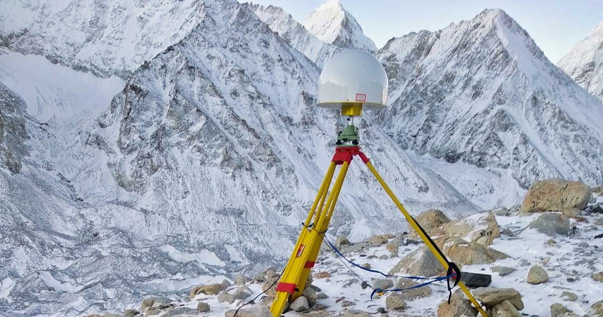
    The survey team and sherpas reach the top of the world. (Photo: CHC Navigation)
    The survey team and sherpas reach the top of the world. (Photo: CHC Navigation)

    China’s field work for new measurements of Mount Everest — the world’s, highest peak — are now complete. However, it will take two to three months for scientists to calculate and release its exact height, according to CHC Navigation, whose GNSS receiver was used.

    The eight-member Chinese survey team reached the summit on May 27. The team erected a survey marker and installed a GNSS antenna on the snow-covered peak. The team also conducted a GNSS survey, snow depth measurement and gravity survey, said China’s Ministry of Natural Resources.

    Scientists will use multiple traditional and modern measurement techniques to perform comprehensive calculations of the measurement data. After data analysis and processing, they will carry out theoretical studies and repeated verifications to determine the accurate height. Complex calculations are needed to eliminate errors caused by factors such as temperature, air pressure and the refractive environment.

  • FCC pushes back on Ligado decision despite GPS interference concerns

    FCC pushes back on Ligado decision despite GPS interference concerns

    U.S. Federal Communications Commission (FCC) Chairman Ajit V. Pai has responded to a congressional letter expressing objections to the April 20 FCC decision to allow Ligado to establish a broadband network.

    In a May 27 email sent to GPS World, the FCC wrote, “Given your interest in the Ligado order that the Commission adopted unanimously last month, we wanted to share with you the text of the letter Chairman Pai recently sent to members of Congress on this topic.”

    The five-member FCC voted unanimously in April to approve an order to allow Ligado Networks to deploy a low-power nationwide 5G network. Experts and policy makers have said the broadband network could — or likely would — interfere with reception of GPS signals.

    On May 7, a bipartisan group of 23 members of the House Armed Services Committee (HASC) sent a letter to the FCC questioning the decision, and this is the letter the FCC is now responding to.

    The letter from Committee Chairman Adam Smith (D-Wash.) and Ranking Member Mac Thornberry (R-Texas) says the FCC order did not comply with Section 1698 of the National Defense Authorization Act for Fiscal Year 2017. That act prevents the commission from approving commercial terrestrial operations in certain portions of the L-band spectrum until 90 days after the commission resolves concerns of harmful interference to GPS devices.

    The Senate Armed Services Committee held a hearing on the topic on May 6 with Department of Defense officials, and on May 15, 32 senators asked the FCC to address their concerns and stay the Ligado approval order while doing so.


    “GPS has no right to operate in the spectrum in question, so there is nothing for Ligado to share.” — FCC Chairman Pai


    The letter insists that GPS will remain protected. “Although your letter references the shared use of spectrum, the Commission’s L-band decision does not authorize any spectrum sharing between Ligado and GPS. In fact, spectrum in this band has been licensed to Ligado and predecessor companies for over 30 years — with those companies authorized to deploy terrestrially since 2004. And as mentioned above, one of the FCC’s conditions require separation of Ligado’s operations from GPS spectrum by means of a 23-megahertz guard band. Thus, any implication that the Commission has authorized Ligado to “share” spectrum that is currently allocated to GPS is incorrect. GPS has no right to operate in the spectrum in question, so there is nothing for Ligado to share.”

    Download the full letter to Rep. Smith here. Download HASC letter to the FCC here.

    The email to GPS World included the following statement: “The FCC is required by law to make its decision based on the facts in the record, and federal agencies, including the Department of Defense, were provided with multiple opportunities to put whatever facts they believed to be relevant into the record, including classified information, which the Commission has a process in place to protect.

    “The Commission based its decision on all of the information in the record.  Moreover, we are not aware of the FCC refusing any request by the Department of Defense to provide a briefing related to this matter.

    “To the extent any federal agency opposed to the Ligado application chose not to share information with the Commission, that was the agency’s decision and suggests that it did not believe that the information in question would bolster its case.”

    Photo: Andrea Izzotti/Shutterstock.com
    Photo: Andrea Izzotti/Shutterstock.com
  • CHC Navigation’s GNSS receivers reach Everest peak

    CHC Navigation’s GNSS receivers reach Everest peak

    CHC Navigation’s P5 geodetic GNSS receiver was successfully used by a Chinese team of surveyors to complete the 2020 Mount Everest Elevation Survey.

    This is the first time that a team of Chinese surveyors has climbed the summit of Mount Everest, and it is also the first time that BeiDou-based Chinese GNSS receivers have been used to measure the height of Mount Everest, known in China as Mount Qomolangma.

    China's National Geodetic Survey Team and its Mountaineer's Team. (Photo: CHC Navigation)
    China’s National Geodetic Survey Team and its Mountaineer’s Team used CHCNAV GNSS receivers. (Photo: CHC Navigation)

    The Everest Project

    To promote research on the Mount Everest elevation and to ensure the scientific character and accuracy of measurements, the Ministry of Natural Resources mobilized the Shaanxi Bureau of Topography and Geographic Information Mapping from the Chinese Academy of Topography and Mapping to plan and implement the measurements of the Mount Everest elevation. China’s National Geodetic Survey Team and its Mountaineer’s Team would undertake the arduous climb.

    The plan set out the technical guidelines and required that the Everest Elevation Project be designed to achieve innovative and technological breakthroughs in several areas of research.

    The first is to use the BeiDou satellite navigation system to perform GNSS measurements; the second is to use Chinese surveying and mapping equipment to complete the task.

    Meeting Harsh Challenges

    In October 2019, CHCNAV received a request from the Ministry of Natural Resources to provide GNSS equipment for the 2020 Everest Elevation Project. A dedicated team combining different departments, from R&D to manufacturing, was set up. The team elaborated the specific technical requirements from the National Survey engineers, in particular the difficulties and challenges related to the altitude of Everest.

    Measuring the height of Mount Everest, especially the summit, is a challenge, not only for the limitation of the human body in such elevation environment, but also for the performance of the GNSS receiver itself.

    At over 8,800 meters, the minimum temperature can reach -45°C and the atmospheric pressure is only 30 kPa (compared to the normal 101 kPa). All the surveying equipment used is exposed to both low temperature and low-pressure constraints.

    In addition, the operation of the instruments must be as simple and reliable as possible in such an extreme environment. Surveyors wear thick winter clothing and lack oxygen, making every movement an extreme challenge. Finally, the measurement of the mountain peak must be completed at the first attempt, as re-measurement is impossible.

    CHCNAV's P5 geodetic GNSS receiver. (Photo: CHC Navigation)
    CHCNAV’s P5 geodetic GNSS receiver. (Photo: CHC Navigation)

    Rugged Solution

    To meet these stringent requirements, CHCNAV has provided GNSS receivers that have passed the most rigorous environmental and reliability tests. The entire solution, from the GNSS receivers to the accessories, has been optimized to ensure mission success from the very beginning.

    A wide temperature range of material — supporting an operating temperature range of –45°C to +85°C — were used, including redesigned lithium-ion batteries offering 12 hours of operation even at extremely low temperatures. Also used were antenna cables with a specific compound material to avoid any cracking or signal attenuation.

    To ensure reliable operation of the receivers in a low-pressure environment, the GNSS receivers have built-in waterproof and breathable valves to maintain internal and external pressures. The low-pressure tests replicated a 25-kPa environment, corresponding to an altitude of 10,000 meters.

    Additional ruggedized reinforcement prevented damage in the event of accidental receiver drop thanks to a robust design to keep the display and connectors safe. Following CHCNAV tests, third-party organizations were commissioned to perform environmental testing and reliability verification, including storage and operating at high/low temperatures, vibration, shock, rain, dust, humid heat, salt and fog.

    From November 2019 to March 2020, CHCNAV’s GNSS equipment was supplied to the National Photoelectric Rangefinder Testing Center — under the requirements of the China Academy of Surveying and Mapping — for the most rigorous evaluation. As a result, the company’s GNSS receivers were selected to provide the peak altitude measurements of Everest in 2020.

    The climb to the summit. (Photo: CHC Navigation)
    The climb to the summit. (Photo: CHC Navigation)

    Reaching the Summit

    On April 5, 2020, at the Everest Elevation Survey Expedition Ceremony in Lhasa, CHCNAV officially donated GNSS equipment to the National Survey Team. Both product and technical training was provided to the team.

    The 53 members of the first National Survey Team overcame the difficulties related to the environment, bad weather and the additional impact of COVID-19, and conducted a series of measurements on Mount Everest and surrounding areas such as level, gravity and GNSS.

    Thirty of the 60 points of the GNSS control network were measured with CHCNAV GNSS receivers, including three of the seven Everest elevation intersection points.

    On May 27, the CHCNAV GNSS receivers finally reached the summit and successfully completed the task.

    The successful achievement of the Everest elevation measurement reflects the performance of the Chinese surveying and mapping industry, confirms BeiDou as a major part of the GNSS systems, and demonstrates the technical success of CHCNAV as a major player in the GNSS industry.

    About CHC Navigation

    Founded in 2003, CHC Navigation is a publicly listed company creating innovative GNSS navigation and positioning solutions. With a global presence across the world, distributors in more than 100 countries, and more than 1,300 employees, CHC Navigation is today recognized as one of the fastest-growing company in geomatics technologies.

  • Focus Telecom installs GPSdome to protect Israel’s ‘national clock’

    Focus Telecom installs GPSdome to protect Israel’s ‘national clock’

    Photo: Inifidome
    Photo: InifiDome

    The national time system at Israel’s National Physics Laboratory (INPL) in Jerusalem is now protected by a GPSdome unit for cyber protection of GPS/GNSS signals, according to Israel’s Homeland Security, a private company established in 2012.

    Microchip partner Focus Telecom installed the GPSdome cyber protection system under a support and maintenance contract. GPSdome was developed by infiniDome, an Israeli startup.

    INPL’s Nadya Goldovsky will now test and measure the system for its ability to protect the GPS/GNSS satellite signals from jamming and other interference. Over the course of several months, Goldovsky will test the system’s ability to protect its four independent atomic clocks, which continuously supply Israel’s national time.

    The cyber protection system is designed to enable continuous, uninterrupted GPS/GNSS service, which allows for full operation of the clocks. During a GPS cyber-attack, infiniDome’s Communication Module will report it to infiniDome’s Cyber Security Cloud.

    “GPSdome is a cyber protection system developed based on military technologies and principals which was adapted to non-military, commercial use,” said Omer Sharar, infiniDome’s CEO. “Our systems are already deployed and operational in Israel at multiple sites in the defense/HLS sector, border protection, financial sector and telecom sector.”

    The company has signed a global distribution contract with an international PNT solution provider to sell its GPSdome systems in more than 120 countries, Sharar said.

  • Seven petitions call on FCC to reverse Ligado order

    Seven petitions call on FCC to reverse Ligado order

    Dozens of parties cite evidence of harmful interference and vast economic harm that FCC ignored in favor of dubious 5G marketing claims

    Dozens of private-sector interests will file Petitions for Reconsideration of the Federal Communications Commission’s (FCC) recent order to allow Ligado Networks to rezone its satellite spectrum holdings for terrestrial mobile use and “flip” them for a profit, according to the Washington, D.C.-based communications firm Glen Echo Group.

    Petitioners will ask the FCC to reconsider its decision, which has generated widespread opposition within the administration, on Capitol Hill and from other aviation and satellite spectrum users. Petitioners include:

    • Airline Pilots Association
    • Association of Equipment Manufacturers
    • Aviation interests (including the Cargo Airline Association, the International Air Transport Association and Airlines for America)
    • Iridium Communications
    • Lockheed Martin
    • Trimble
    • RNT Foundation

    The petitioners argue the FCC’s Order ignored or improperly disregarded the great majority of evidence, including technical analyses submitted by parties showing harmful interference, and relied instead on “easily disproven claims that Ligado will provide a so-called 5G service,” the Glen Echo Group stated in a press release.

    “The L-band is not included in any internationally recognized 5G standard, the spectrum is not harmonized regionally or globally for 5G, FCC’s 5G FAST Plan does not include Ligado or L-Band spectrum nor does the company have enough contiguous spectrum,” the release stated.

    Airlines for America. “Airlines for America (A4A) strongly supports a broad industry coalition that has led at least 32 U.S. Senators from both sides of the aisle to urge the FCC to stay and reconsider granting Ligado Networks’ petition to repurpose critical frequency spectrum for ‘5G’ terrestrial communications services. The FCC’s rushed order in April ignored testing protocols intended to protect critical users likely to be impacted, including aviation uses of Global Positioning Systems (GPS) for navigation, and satellite communications. Beyond industry opposition, the U.S. Department of Defense also strongly opposed the FCC’s action.

    “A4A is joining other industry constituents in directly petitioning the FCC to reverse its course, the effects of which could impact the safety of the flying public and impact operations, especially harmful outcomes in the recovery period following the COVID-19 pandemic.”

    Aerospace Industries Association. The association represents more than 300 companies.
    “Uninterrupted access to GPS is essential not only for our industry, but also for the American people, our national security, and the strength of the U.S. economy. This access is now threatened by the FCC’s decision to grant Ligado Networks’ application, despite years of evidence and the concerns outlined by several federal agencies about potential interference. With this motion, we are banding together to urge the FCC to reconsider this decision and allow safety and data to drive their decision-making on spectrum.”

    The International Air Transport Association (IATA), which represents some 290 airlines or 82% of global traffic said, “Approving Ligado’s spectrum for 5G poses a strong risk of interference with GPS signals, including the potential interruption of GPS signals at low altitudes. The FCC should reverse this decision.”

    Air Line Pilots Association (ALPA). President Capt. Joe DePete said, “Throughout its report and order, the FCC uses words like ‘possible’ and ‘feasible’ when talking about whether Ligado can operate. These are not the words you would want to hear your Captain use when talking about successfully completing your flight the next time you are sitting in the cabin. Aviation requires certainty and guaranteed performance from its systems. The FCC’s hasty, arbitrary, and incorrect decision will set a disastrous precedent that will impede ongoing work on spectrum sharing. The Ligado decision must be reversed immediately.”

    Aviation Spectrum Resources Inc. “In jointly filing a petition for reconsideration of the FCC’s recent decision on Ligado Networks’ proposal, ASRI joins the wider aviation community in expressing our view that the decision is based on a fundamentally flawed interpretation of the data that have been presented to the Commission. Among other deficiencies, the FCC’s decision ignores the FAA’s reservations cited by the Department of Transportation, having implications for many low-level aircraft operators including helicopters and UAVs. The FCC Order also seems to acknowledge the mounting evidence that aviation safety satellite communications will receive interference, but it relies on the completion of private negotiations to resolve these questions while giving Ligado a green light to proceed, rather than requiring specific mitigations itself. ASRI believes the FCC should revisit its decision in conjunction with aviation experts to ensure the safety of air transport, medivac and other essential aviation operators are not affected by this decision.”

    Iridium Communications. CEO Matt Desch said, “The FCC’s Ligado action prioritizes economic windfalls to a few speculators over safety of life, national security and important private sector companies whose customers would be most upended by their harmful interference.”

    RNT Foundation. President and Director Dana A. Goward said, “The FCC treated this like a commercial communications issue instead of a decision about safety-of-life navigation. They didn’t even consider the overall cost to the public in lost lives and property.”

    In addition to private sector interests, 14 federal agencies and numerous Republican and Democratic members of Congress oppose the FCC’s decision in favor of Ligado.


    Feature image: A-Digit/DigitalVision Vectors/Getty Images