Bentley Systems‘ Year in Infrastructure 2020 conference will be hosted in a digital format.
The virtual Year in Infrastructure 2020 conference will provide complimentary access to a wide range of content relevant to infrastructure professionals in every role and at every phase of the infrastructure lifecycle, the company said.
Highlights of the 2020 conference will include the Year in Infrastructure 2020 awards finalists’ presentations, which will be held Oct. 5-16; the Year in Infrastructure 2020 Executive Perspectives, which will be held Oct. 20-21; a TwinTalks premier on Oct. 20; the Year in Infrastructure 2020 awards ceremony on Oct. 21; and Accelerate Sessions, which will take place Oct. 27 and beyond.
During the Executive Perspectives session, Bentley Systems CEO Greg Bentley will be joined joined by leading infrastructure executives for an interactive discussion on the resilience challenges they face and how to meet those challenges through digital advancement. In addition, Bentley Systems Founder and Chief Technology Officer Keith Bentley will discuss the company’s open strategy for digital twins.
The TwinTalks will feature leading industry figures as they discuss the implications of digital twins for digital cities, design and construction, digital plants, energy utilities, rail and transit, and roads and bridges.
The Accelerate sessions will feature Bentley product executives, including Dustin Parkman (project delivery), Robert Mankowski (digital cities), Ken Adamson (design integration), and Alan Kiraly (asset and network performance), as they and their leadership teams review the latest advancements in Bentley applications and cloud services.
Bentley Systems, headquartered in Exton, Pennsylvania, provides comprehensive software and digital twins services for advancing the design, construction and operations of infrastructure.
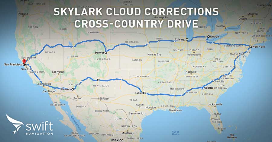
Swift’s first-of-its-kind, cross-continental drive demonstrates the performance of Skylark. (Image: Swift Navigation)
Swift’s first-of-its-kind, cross-continental drive demonstrates the performance of Skylark.
Swift Navigation, a San Francisco-based tech firm redefining GNSS and precise positioning technology for autonomous vehicles, has completed a cross-country drive test.
The goal of this first-of-its-kind drive, from San Francisco to New York and back, was to measure the efficacy of Swift’s recently expanded Skylark cloud corrections service and to demonstrate true nationwide lane-level GNSS correction coverage at the accuracy, reliability and availability levels required by Swift customers.
The drive took the Swift team across 26 states and Washington, D.C., with 6,614.7 miles (10,645.4 km) driven over 116 hours and 14 minutes logged. A Swift vehicle was equipped with 20 different GNSS devices, tested using six unique chipsets that included: Swift’s Piksi Multi, Duro and multiple leading GNSS silicon providers.
The results of the drive confirmed that Swift’s precise positioning solution — composed of Skylark and the Starling positioning engine — delivers consistent lane-level accuracy at continental level. Skylark delivered 100% availability, with sub-decimeter accuracy, over the entire United States, wherever cellular coverage was available.
Performance highlights from the drive:
+Sub-meter horizontal accuracy (2-sigma) achieved across all environments
100% Skylark availability
Highly repeatable results with Starling + Skylark across variety of dual-frequency GNSS chipsets
“This is the longest continuous GNSS-based precise positioning drive test of its kind and we are proud of the engineering team at Swift for undertaking this ambitious task,” said Anthony Cole, executive vice president of engineering. “The results show that Skylark performs as intended and expected in both open sky and urban environments and demonstrate that Skylark is truly a cross-continental corrections network delivering the high integrity and high availability required by automotive OEMs, last-mile applications, rail, mobile and micro-mobility companies.”
In addition to full contiguous U.S. (CONUS) coverage, the Skylark corrections service is now available in Europe and is being built out to support autonomous applications across the globe.
Download a complete write-up of the cross-country drive test at www.swiftnav.com.
Version 8.5 of SimActive’s Correlator3D mapping software allows users to share and visualize projects in the cloud. (Photo: SimActive)
SimActive has launched version 8.5 of its Correlator3D mapping software. According to the company, this new version users to share and visualize projects in the cloud. More specifically, results can be exported to the cloud directly from the software interface, and shareable links are automatically created for online visualization.
Version 8.5 also features tools for the calibration and processing of multispectral imagery. Calibrated reflectance panels and sun sensors can be used to produce reflectance maps, with multispectral bands perfectly registered, the company said.
“Our software attracts a variety of clients, with a wide range of needs,” said Louis Simard, CTO at SimActive. “This new version brings advantages to customers having data exploitation requirements such as online viewing, and to users processing imagery from highly sophisticated sensors.”
SimActive, founded in 2003 and based in Montreal, Quebec, develops photogrammetry software. Its Correlator3D software, is a patented, end-to-end photogrammetry solution for the generation of high-quality geospatial data from satellite and aerial imagery.
The technology multinational GMV has won a contract under the Spanish Ministry of Defense’s (MoD’s) RAPAZ program for the supply of four Class I Seeker RPASs to be integrated into the intelligence units of the Paratrooper Brigade and the Tercio de Armada de Infantería de Marina (Marine Infantry Protection Force).
The contract will provide the armed forces with the most advanced version of the unmanned aircraft Seeker.
The UAS Seeker is an autonomous, rapid-deployment system developed by Aurea Avionics and supplied by GMV. It provides intelligence, surveillance and reconnaissance capabilities over a 15-kilometer range with a 90-minute endurance and a weight of 3.5 kg.
The aircraft will strengthen the intelligence, surveillance and reconnaissance capabilities of Spanish troops, ensuring better operational capability and tactical superiority.
Seeker constitutes the core of a situational awareness system, providing real-time intelligence. It is designed for rapid-deployment and high-mobility military applications carrying out low-level intelligence, surveillance and reconnaissance tasks.
The system components can be broken down into two major groups: the air segment and the ground segment. The air segment comprises the unmanned aerial system (UAV), fit for daytime and nighttime operations and capable of completely autonomous flying. The ground segment comprises a ground control station, a ground data terminal, and a remote handheld control. These systems between them monitor the UAV’s operation and process its real-time video data.
Within this project, due for delivery by October 2020, GMV will be running the design and manufacturing activities and also the various flight campaigns scheduled to check that the systems work properly before handover to the MoD.
GMV developments for unmanned aircraft
GMV boasts great expertise and experience in Unmanned Aerial Systems (UAS), built up on the strength of many previous projects such as ATLANTE, where it developed the aircraft’s flight control computer; EGNSS4RPAS, where it weighed up EGNOS performance for RPAS operations; and DOMUS, where it developed emergency-management and -monitoring service demonstrators for drone traffic control under the U-Space system.
This Spanish MoD Seeker system supply contract boosts GMV’s growing renown as developer and supplier of UAV systems and services.
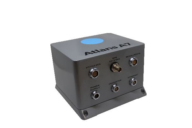
Oceanographic & Geophysical Instruments (OGI) has selected iXblue’s Atlans INS to provide robust and uninterrupted data georeferencing to its newly unveiled mobile-mapping lidar solution dedicated to road assessment surveys.
A fully integrated mobile mapping solution, this new vehicle-based system integrates advanced systems to provide highly detailed georeferenced survey data to transportation departments throughout the United States.
“Highly accurate and reliable georeferencing of the collected data being crucial for road assessment operations, we were seeking a compact and robust navigation solution for our mobile scanner project,” said Darren Moss, program manager at OGI. “We tested other inertial navigation systems (INS) during mobile surveys in New York City and Boston with poor results, as those INS units relied mainly on GPS signals. Maintaining good GPS signals in the urban canyons of large cities proved to be impossible. This deeply impacted the georeferencing of the acquired lidar data, leading to highly inefficient operations. This is the reason we turned to iXblue’s Atlans A7 INS.”
Based on fiber-optic gyroscope (FOG) technology, the Atlans A7 north-seeking INS offers highly accurate and robust data georeferencing. Resistant to GPS outages, it enables continuous acquisition operations within environments lacking continuous GPS signals. The Atlans A7 is a valuable system for high-accuracy data acquisition without interruption.
“Working with iXblue in other markets, we were familiar with the high-quality instrumentation they are known for. We were confident their FOG-based INS systems would perform even during GPS outages,” Darren said. “By choosing the Atlans A7, we are assured to get robust and uninterrupted georeferenced data in urban environments, tunnels, forests, and mountainous areas, which is crucial for our customer’s operations. With this INS, iXblue brings high-end FOG performance to the mobile-mapping industry at a very affordable price.”
“The Atlans A7 integrates very well within our new mobile lidar solution and, combined with Teledyne Optech Polaris high-resolution lidar scanner and QPS Qinsy display and acquisition software, it brings high-accuracy and efficiency to the core of our Mobile lidar solution,” Darren said.
TDC’s Freeance field applications leverages Trimble GNSS for accurate, streamlined data collection
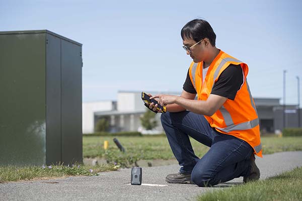
TDC Group has joined Trimble’s GIS (geographic information system) Business Partner Program. As part of the program, TDC has implemented the Trimble Precision SDK (software developer kit) to integrate high-accuracy positioning capabilities in its Freeance mobile software applications running on tablets and smartphones using Trimble GNSS receivers.
Freeance provides field crews with simple yet powerful and configurable location-based mobile apps to manage data collection and inspection activities across utility and public works organizations. By adding the Trimble R1 and R2 receivers to Freeance workflows, users are empowered with real-time access to high-quality, reliable data.
The Trimble R1 receiver will be accessible with TDC’s Freeance software. (Photo: Trimble)
“Trimble recognizes the value our GIS software partners bring to our customers by delivering targeted, industry-specific solutions,” said Stephanie Michaud, strategic marketing manager, Trimble Survey & Mapping Field Solutions. “We’re very pleased to collaborate with TDC and leverage their domain expertise, and to integrate Trimble technology into the Freeance solution for the utilities and public works markets. As a direct result of this relationship, Freeance users can now work with the confidence of knowing their field workflows are precision-enabled with Trimble GIS technology.”
“We’re excited about the integration of high-accuracy Trimble GNSS receivers with Freeance software that enables organizations to add sub-meter or better accuracy to mobile workflow activities using smartphones and tablets,” said Matthew Reddington, CEO of TDC Group. “Adding high-accuracy positioning to field workflows by means of simple mobile apps paired with Trimble GNSS increases the quality and uses of data captured during field operations.”
The U.S. Department of Homeland Security (DHS) issued a report on alternative sources of PNT on May 6. It was submitted to U.S. congressional committee leaders on April 8.
Section 1618 of the 2017 National Defense Authorization Act (NDAA) of Dec. 23, 2016, required the DHS to address the need for a GPS backup by identifying and assessing viable alternate technologies and systems.
The report is a summary and analysis of that assessment by the Homeland Security Operational Analysis Center (HSOAC) of PNT systems currently used by critical infrastructure. It also provides recommendations for the federal government’s next steps to increase the resilience of critical infrastructure to disruption of GPS services.
In the report, DHS offers the following recommendations to address the nation’s PNT requirements and backup or complementary capability gaps:
Temporary GPS disruptions: End users should be responsible for mitigating temporary GPS disruptions. For example, the Federal Aviation Administration maintains sufficient PNT capabilities to assure the continued safe operation of the national airspace, albeit at a reduced capacity, during GPS disruptions. The federal government can facilitate this mitigation for various critical infrastructure sectors, but should not be solely responsible for it.
PNT Diversity and Segmentation: The federal government should encourage adoption of multiple PNT sources, thus expanding the availability of PNT services based on market drivers. Encouraging critical infrastructure owners and operators to adopt multiple PNT systems will diffuse the risk currently concentrated in wide-area PNT services such as GPS. Federal actions should focus on facilitating the availability and adoption of PNT sources in the open market.
System Design: PNT provisioning systems, assets, and services must be designed with inherent security and resilience features. Critical infrastructure systems that use PNT services must be designed to operate through interference and to identify and respond to anomalous PNT inputs. These attributes are applicable to the PNT receivers and the systems that use them.
Pursue Innovation that Emphasizes Transition and Adoption: Incorporating PNT signal diversity into the PNT ecosystem should be pursued with an emphasis on research and development that prioritizes successful transition and adoption into existing GPS receivers, taking into account factors such as business case considerations, financial costs, technical integration, and logistical deployment.
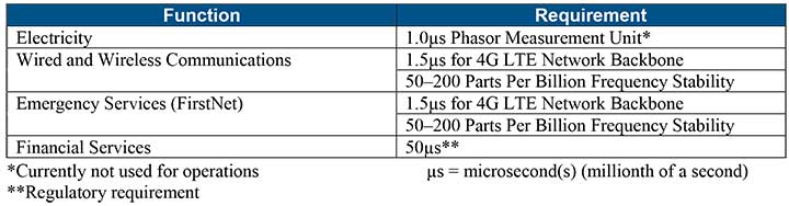
Table 1 shows timing requirements for critical infrastructure are, according to the report.
Table 1. (Image: DHS report)
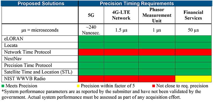
Table 2 from the report shows proposed timing solutions submitted by industry to DHS during a Request for Information (RFI) in December 2018. Systems that can meet or exceed timing requirements for critical infrastructure are indicated in green.
Table 2 (Image: DHS report)
Satelles responds
The Satelles company, which offers STL, issued a statement on the report. “This important report highlights the urgent need for GPS backup for critical applications, and it identifies and characterizes a variety of solutions that are available to meet this need today,” said Michael O’Connor, CEO of Satelles. “The report also describes the essential role of the federal government in urging industry to implement multiple technologies, without making the mistake of providing or selecting a single PNT solution.”
Continued O’Connor, “DHS goes on to define a baseline requirement for timing services accuracy for critical infrastructure. Not only does Satelles meet or exceed the precision timing specifications stated by DHS, but also our solution provides national coverage (including Alaska, Hawaii, and U.S. territories) and is commercially available now.”
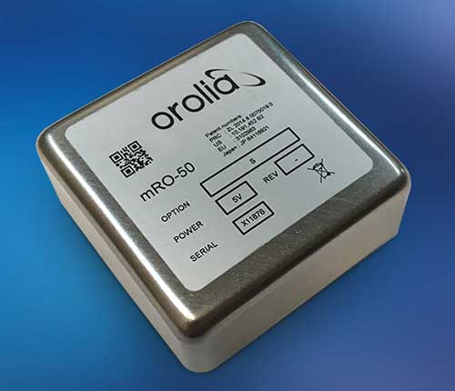
Orolia has introduced a low SWaP-C miniaturized rubidium oscillator, the Spectratime mRO-50, designed to meet the latest commercial, military and aerospace requirements where time stability and power consumption are critical. The oscillator is low SWaP-C — size, weight, power and cost.
The Spectratime mRO-50 provides a one-day holdover below 1 µs and a retrace below 1 x 10⁻¹⁰ in a form factor sized 50.8 x 50.8 x 19.5 millimeters. It takes up only 51 cc of volume — about one-third of volume compared to standard rubidiums — and consumes only 0.45 W of power.
he Spectratime mRO-50 miniaturized rubidium oscillator provides accurate frequency and precise time synchronization to mobile applications, such as military radio-pack systems in GNSS-denied environments. Its operating temperature of -10°C to 60°C (military version extends to -40°C to 75°C) is also suitable for UAVs and underwater applications.
Orolia is a leader in space-based atomic clocks and high-end crystal, rubidium, hydrogen maser and integrated GPS/GNSS clocks. The company also provides testing instruments for space missions that rely on high precision atomic clock technology.
Orolia’s Atomic Clocks team received the 2019 PTTI Distinguished Service Award in January for advancing the state of the art in high-stability atomic clocks and producing the only space-based passive H-maser in the world, operating on all Galileo satellites. Spectratime mRO-50 is the latest technology solution from this award-winning team.
“Through Orolia’s continuous commitment to innovation, we are proud to offer our customers more precise PNT data in a cutting-edge, lightweight form factor for mobile missions,” said Orolia’s Atomic Clocks Product Line Director, Jean-Charles Chen.
Driven by COVID-19, the uptick in adoption supports collaboration among remote workers as businesses adapt.
The Trimble Connect cloud-based collaboration platform has surpassed 10 million users. In response to COVID-19, distributed working has intensified the need for teams to share information and collaborate remotely, leading 1.2 million users to join Trimble Connect in March and April alone.
To date, Trimble Connect has hosted more than 80,000 design and construction projects, making it possible for people to collaborate and work together from anywhere in the world.
Photo: Trimble
Trimble Connect is an open collaboration platform for design and construction that connects project stakeholders with the data they need to inform decisions and improve team efficiency. Project stakeholders can share, review, coordinate and comment on data-rich constructible models, schedules and critical project information in real time — reducing costly miscommunication and improving coordination to keep projects on time and on budget.
In addition to adding new users, the activity on Trimble Connect has shown a considerable increase in collaboration for businesses in the architecture, engineering and construction (AEC) industry.
The number of invitations to collaborate on projects increased 58% in April over the previous month, indicating that users are adjusting to new remote and distributed working dynamics and enabling teams to stay resilient, despite interruptions to their traditional daily routines.
“This is an exciting milestone for Trimble Connect,” said Ray Bagley, business area director for Trimble Connect. “Businesses in the AEC industry need an open, common data environment that allows project stakeholders to unlock the real value of building information modeling (BIM), civil construction and geospatial data. The increased adoption of Trimble Connect in recent months shows us that businesses need reliable, open collaboration more than ever before.”
Trimble Connect’s open API enables data-flow to and from a variety of applications and allows users to customize workflows by integrating with existing enterprise solutions. Users can access project files stored on Trimble Connect directly through a wide range of solutions, including Tekla Structures software, Trimble Access field software, Trimble FieldLink layout software, SketchUP 3D modeling software and ProjectSight construction management software as well as third-party applications.
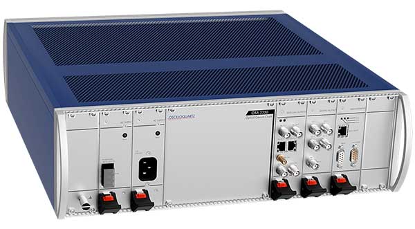
ADVA has launched a ePRC optical cesium atomic clock solution to protect synchronization networks during GNSS disruptions. The OSA 3350 ePRC+ offers vital backup for mission-critical infrastructures that depend on satellite-based timing, such as mobile networks and power utilities.
The Oscilloquartz OSA 3350 ePRC+ provides high stability and long life, as well as built-in support for Simple Network Management Protocol (SNMP) . It also meets stringent performance demands as well as the cost points needed for mobile networks transitioning to 5G.
Featuring an all-digital design, the OSA 3350 ePRC+ leverages optical-pumping techniques. It greatly improves performance by providing an extremely stable frequency source.
When used with enhanced primary reference time clocks (ePRTCs), the OSA 3350 ePRC+ delivers holdover for 14 days with an accumulated error of up to 35 nanoseconds. This far exceeds the ITU-T ePRC G.811.1 standard that requires an accumulated error under 70 nanoseconds.
The OSA 3350 ePRC+ also delivers optimum stability for more than 10 years, much longer than the lifespan of high-performance magnetic cesium clocks.
With a fully modular design, the optical cesium solution features a wide range of telecom synchronization output interfaces and supports modern and secured management capabilities with SNMP. It is RoHS-compliant and is fully integrated into ADVA’s Ensemble management and control software suite for operational simplicity and ease of use.
This column will address why users will be required to perform GNSS occupations when submitting a leveling project to the National Geodetic Survey (NGS) after 2022. It will highlight a section of NGS Blueprint for 2022, Part 3, “Working in the Modernized NSRS,” that discusses the process of performing leveling projects after 2022. My October 2017 column briefly discussed NGS’ preliminary plans for incorporating geodetic leveling data into the North American-Pacific Geopotential Datum of 2022 (NAPGD2022) to establish orthometric heights consistent with GNSS-derived NAPGD2022 orthometric heights. It emphasized that after NAPGD2022 is established, the primary means for deriving orthometric heights on monuments will be using GNSS observations combined with the geoid model.
As a side note, NGS just released NOAA Technical Report NOS NGS 72–GEOID18, a report that provides a comprehensive explanation of the data and methods used to create the latest NGS hybrid geoid model. My February 2020 column provided an analysis of the differences between the latest published hybrid Geoid18 values provided on NGS’ Datasheet and the computed geoid height value using the published NAD 83 (2011) ellipsoid height and NAVD 88 orthometric height.
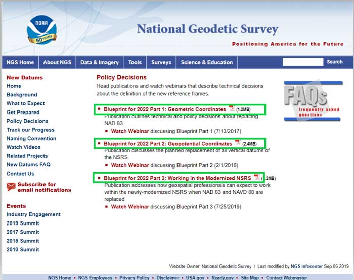
In support of the modernization of the National Spatial Reference System (NSRS), NGS has published three documents denoted as Blueprints for 2022 that describe the modernization of the NSRS (see the box titled “NSRS Modernization NGS Blueprint Documents”).
There are several sections in NGS Blueprint for 2022, Part 3, “Working in the Modernized NSRS,” that discuss the process of performing leveling projects after 2022. Something that will be new after 2022 is that NGS will require users to perform GNSS occupations in order to incorporate their leveling results into the new modernized NSRS.
NGS realizes that in the immediate future GNSS will not replace geodetic leveling for determining the most accurate local orthometric height differences. NGS’ plans include preparing a new leveling manual that will explicitly explain how to work in the modernized NSRS. Some of the new surveying procedures are described in Section 2.10 of Blueprint part 3. In section 2.10, NGS states that there will be substantial changes in how they process and serve up survey data, and that there will be some new ways of executing surveys. This column will focus on sections “2.10.2 Leveling” and “2.11.5 Leveling on Passive Marks” that discuss the new procedures for executing leveling surveys in the modernized NSRS. One major change is that leveling surveys will require Global Navigation Satellite System (GNSS) occupations to ensure orthometric heights computed in leveling surveys are up-to-date and are connected to the NSRS through the NOAA CORS Network. After the modernization of the NSRS in 2022, the NOAA CORS Network will be the primary access to the NSRS. This means leveling and classical surveys will require GNSS surveys to be part of the project. NGS’ plans include creating an OPUS option for processing all types of surveys. Users will be able, within OPUS, to adjust their projects using any mix of CORS data and passive control. Saying that, these same projects, on submission, will be deconstructed at NGS and reduced to the raw observations, then adjusted solely to the NOAA CORS Network to determine Final Discrete coordinates every GPS Month. The GPS Month concept may be new to some users. Blueprint Part 3 describes the concept in section “2.11.3 GNSS on Passive Marks.” The basic concept of a GPS Month is that it is four consecutive GPS weeks, with the first week in the GPS month having a GPS week number that is a multiple of four (see box titled “Definition of a GPS Month”).
Definition of a GPS Month
GPS month: Four consecutive GPS weeks, with the first week in the GPS month having a GPS week number that is a multiple of 4.
In this fashion, NGS defines:
GPS month 0 = GPS weeks 0, 1, 2, and 3 (1/6/1980 through 2/2/1980)
GPS month 1 = GPS weeks 4, 5, 6, and 7 (2/3/1980 through 3/1/1980)
GPS month 2 = GPS weeks 8, 9, 10, and 11 (3/2/1980 through 3/29/1980)
…
GPS month 513 = GPS weeks 2052, 2053, 2054, and 2055 (5/5/2019 through 6/1/2019)
etc.
So, what does this really mean to the user when performing a leveling project in 2022? For a leveling project to be processed using NGS software and/or submitted to NGS for inclusion into the NSRS database, the user must follow specific rules.
The following is from Blueprint, Part 3, section “2.10.2 Leveling:”
“As GNSS occupations are required for geodetic leveling, the rules for how many and how frequently will be:
For a leveling project to be processed using NGS software and/or submitted to NGS for inclusion into the NSRS database, its field observations should not span more than one year. Longer projects should be broken into sub-projects of less than one year.
A minimum of three “primary control marks” must be in the level network for every project.
More primary control marks should be added so there is never more than a 30-kilometer linear distance between marks in the entire network.
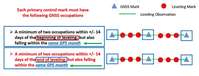
Each primary control mark must have the following GNSS occupations (details on using GNSS occupations to work in the NSRS will be found in the update to NGS 58):
A minimum of two occupations within +/- 14 days of the beginning of leveling, but also falling within the same GPS month and whose local start times are separated by between 3 and 21 hours.
It is preferable, but not required, that all occupations on any primary control mark occur within the same GPS month as those of all other primary control marks.
A minimum of two occupations within +/- 14 days of the end of leveling, but also falling within the same GPS month and whose local start times are separated by between 3 and 21 hours.
It is preferable, but not required, that all occupations on any primary control mark occur within the same GPS month as those of all other primary control marks.
All projects exceeding six months must have a third set of GNSS occupations on all primary control marks some time near the middle of the project, without a rigorous rule as to when. They must follow the “minimum of two occupations” rule as per above, and each mark’s occupation is required to fall in the same GPS month, with a preference that all primary control marks are occupied in the same GPS month.”
The box titled “GNSS Procedures for Leveling Projects” highlights the GNSS rules that need to be adhered to when performing leveling projects in 2022.
GNSS procedures for leveling projects
For the Immediate Years Following 2022, NGS Will Require That all Leveling Projects Turned in Have GNSS on Primary Control
Minimum of 3 Points with a Maximum Spacing of 30 km
At Least Two Occupations of Each GNSS Primary Control:
+/- 14 days of Beginning of Leveling
Within the Same GPS Month
+/- 14 days of Ending of Leveling
Within the Same GPS Month
Diagram: David B. Zilkoski
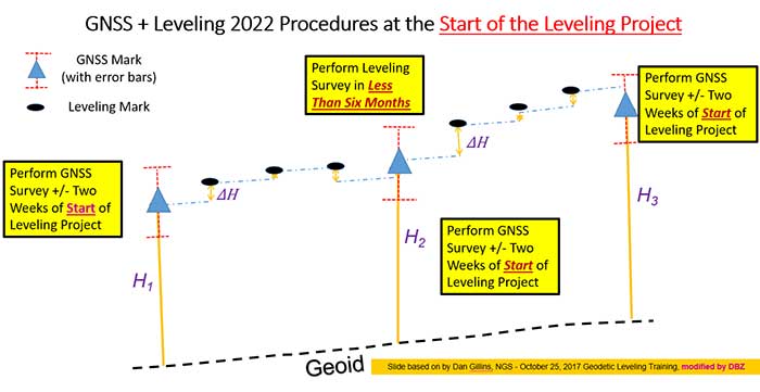
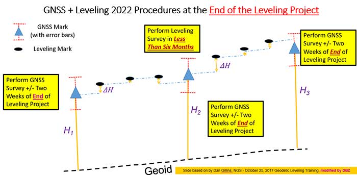
The boxes titled “GNSS + Leveling 2022 Procedures at the Start of the Leveling Project” and “GNSS + Leveling 2022 Procedures at the End of the Leveling Project” provide conceptual diagrams that illustrate what this means to a typical leveling project.
Diagram based on information from Dan Gillins, NGS, and modified by David B. ZilkoskiDiagram based on information from Dan Gillins, NGS, and modified by David B. Zilkoski
So, why is NGS requiring users to perform GNSS observations in support of leveling project. Leveling is a differential measurement technique; it generates relative height differences not absolute heights. In NGS’ modernized, time-dependent 2022 NSRS, the absolute height will be provided by up-to-date GNSS data; and the accurate relative height differences between leveling marks will be provided by the leveling data. (See box titled “Why NGS Requires GNSS Occupations on Primary Marks.”)
Why NGS requires GNSS occupations on primary marks
The Connection to NAPGD2022 is Obtained Through GNSS and a High-Accuracy Geoid Model
Network Accuracy
The Accuracy of the Height Differences are Provided Through the Leveling Data
Local Accuracy
Combining the leveling and GNSS increases the redundancy in a survey network
NGS is developing models and tools to facilitate the incorporation of leveling survey data and adjustment results into the new modernized NSRS in 2022. Blueprint, Part 3, section “2.13.3 OPUS for Leveling,” describes NGS plans to support leveling surveys through the use of the OPUS web tool. The box titled “OPUS for Leveling” outlines how NGS will modify the OPUS web tool to support leveling surveys.
OPUS for leveling
Support for leveling surveys will follow many of the best aspects of OPUS
Uploading and processing digital data files
Using a web-based graphical interface
Submitting data to NGS
Leveling is a differential measurement technique
It generates relative height differences not absolute heights
For users who need absolute heights in the NSRS
OPUS will support a mix of GNSS and leveling in a single project
NOTE: NGS will require a GNSS survey to be performed at specific times before and after leveling surveys in order for the data to be submitted for inclusion in the modernized NSRS after 2022.
NOTE: Leveling surveys longer than one year must be broken up into multiple projects. Leveling surveys between 6 and 12 months in duration require a third, intermediary GNSS data collection.
This column highlighted that in the modernized NSRS the only way to get “into the datum” will be through a GNSS survey. It noted that leveling projects generate relative height differences not absolute heights. In NGS’ new modernized, time-dependent NSRS, the absolute height will be provided by up-to-date GNSS data; and the relative height differences between leveling marks will be provided by the leveling data. A major requirement will be that users must collect GNSS data both at the beginning and at the end of a leveling survey project. Leveling survey projects that take longer than one year to complete must be broken up into multiple projects. NGS is developing model and tools to facilitate incorporating all types of survey data into the new NSRS. I would encourage all readers to read NGS’ Blueprint for 2022 documents to obtain a better understanding of the new, modernized NSRS.
Brazilian geoscience services company OceanPact Geociências has chosen deep-water positioning technology from Sonardyne Brasil Ltda. to support its geophysical, geotechnical and environmental research operations across the region.
Ranger 2 ultra-short baseline (USBL) systems have been installed on board OceanPact’s research vessel Seward Johnson and RSV Austral Abrolhos to precisely track the location of underwater equipment and sensor packages deployed from the ships, including seabed corers, towed sensors and data loggers. Both vessels are currently on hire to Brazilian oil major Petrobras.
Ranger 2 USBL is a popular choice for conducting research at sea as operations can start as soon as a vessel arrives on location. This helps maximise valuable ship time. It has the capability to track multiple underwater targets simultaneously to beyond 11 kilometers, works in shallow or deep water and is able to remotely configure and communicate with compatible instruments. This operational flexibility was a key factor in OceanPact’s investment decision.
“This order from OceanPact further embeds Ranger 2’s reputation in the region. For those wanting accuracy and versatility, it’s proven itself time and again while also meeting the toughest specifications from oil and gas, science and survey companies,” Andre Moura, sales and applications manager at Sonardyne Brasil Ltda.