Category: Applications

  • Delivering the world through maps

    Delivering the world through maps

    GIS ready to meet demands of IoT, smart cities

    The mapping industry has taken to UAVs — sort of. Put it this way: UAVs are only one tool in the GIS (geographic information system) toolbox.

    A third of our respondents (32%) say that UAVs will be used for less than 10% of field survey activity in the next three years. In contrast, a quarter of our respondents say that drones with variety of sensors (photogrammetric, lidar, hyperspectral, etc.) will perform up to half of mapping work.

    The response is similar to replies in 2018. While UAVs are an exciting new technology for mapping, most respondents to our survey recognize the continued value of hands-on, in-the-field data collection. In fact, only 11% of respondents expect that mapping work on the ground will gradually disappear over the next three years.

    Chart: GPS World
    Chart: GPS World

    Sensors Aboard. When on board a UAV, 43% say the best sensor to use in conjunction with GPS/GNSS for mapping and data collection is a high-resolution still-image camera, which is highly preferred over video cameras. Today’s high-resolution cameras can capture details down to a few centimeters on the ground, even from an aircraft hundreds of feet in the air (see our August issue for more on aerial mapping).

    Other top sensor choices for our readers include lidar (light detection and ranging) at 32% and multispectral imaging cameras at 14%. Lidar (light detection and ranging) uses a pulsed laser to measure distances and generate precise, three-dimensional information.

    Rather than UAVs, airplanes and helicopters are the most commonly used platforms for acquiring lidar data over broad areas. Topographic lidar uses a near-infrared laser to map the land, while bathymetric lidar uses water-penetrating green light to measure seafloor and riverbed elevations. Lidar is used to create more accurate maps, make digital elevation models, assist in emergency response operations, to name a few applications. GNSS and INS systems translate the collected sensor data into static points for GIS.

    Multispectral and hyperspectral cameras capture images in infrared (IR) and ultraviolet (UV) as well as traditional RGB (red, blue, green). The main difference between multispectral and hyperspectral is the number of bands and how narrow the bands are — from 3 to 10 bands for multispectral to hundreds for hyperspectral. Practically speaking, multispectral imagery can be used to map forested areas, while hyperspectral imagery can be used to map tree species within the forest.

    Both types of cameras are used in agriculture, ecology, oil and gas, oceanography and atmospheric studies. They can map invasive species, monitor crop health, and help in mineral exploration. For building inspections, a multispectral camera can see water penetration, plumbing leaks, overloaded electrical circuits and malfunctioning mechanical systems.

    Chart: GPS World
    Chart: GPS World

    Cloudy, Chance of Maps. Anywhere, anytime access to geospatial data is increasingly important, fueled in part by both the internet of things (IoT) and smart-city initiatives. Geospatial technology enables effective and integrated planning by providing real-time location data and analytics.

    Most mapping providers have developed cloud software and storage, which helps organizations access data to meet their specific requirements. Along with the cloud, advances in mobile computing are enabling organizations to take GIS to the field, interacting with the information needed to view, capture, update and synchronize changes between the field and office. The field workforce can use maps to add validity to data, record observations, and respond to events.

    GIS software is also assisting connected cars and autonomous vehicles, an area expected to grow significantly (see page 38). The mobile GIS software market is expected to reach a CAGR of 18% by 2024, according to Global Market Insights.

  • Autonomy relies on GNSS/INS

    Autonomy relies on GNSS/INS

    In transportation and machine control

    It’s hard to overstate the importance of inertial sensors in the transportation and machine control markets. For the second year, using inertial navigation systems (INS) to augment positioning was selected by the most respondents (43%) as the best additional solution for positioning in GPS/GNSS-challenged environments.

    Inertial measurement units are based on multi-axis combinations of precision gyroscopes, accelerometers and magnetometers using algorithms to determine location, direction and position. Other tech used to increase positioning accuracy includes signals of opportunity (cellular, radio, TV), visual indicators (such as lidar) and ultra-wideband.

    Automakers are pushing hard to get autonomous vehicles on our roads and highways. Nissan and Renault (with Microsoft) plan to have 10 vehicles on sale by 2020 with “significant autonomous functionality.”

    Ford plans to roll out autonomous vehicles by 2021, and Hyundai is targeting them for the highway by 2020 and urban driving by 2030. While industry experts debate the time frame, it’s clear autonomous vehicles are coming.

    Every Tier 1 automaker has an autonomous navigation program, along with heavyweights such as Google, Apple an Amazon. Many automakers are teaming with tech companies on R&D, such as GM with Lyft, and BMW with Intel and Mobileye. Others are teaming with each other —Volkswagen and Ford partnered to acquire AI startup Argo. Daimler has joined Volvo to invest in the platooning concept, connecting trucks through wireless signals.

    Stages of Autonomy. The move to autonomous won’t be a sudden jump, but will take place in incremental steps. Formerly only offered on luxury autos such as the Tesla or Mercedes, Honda has introduced semi-autonomous advanced-driver assistance systems (ADAS) options on its entry-level Civic, offering lane-keeping, automatic braking, and adaptive cruise control functionality for the mass market.

    Automakers rely on SAE International’s J3016 standard, which defines six levels of automation from Level 0 (no automation) to Level 5 (full vehicle autonomy). The pivotal change occurs between Levels 2 and 3, when responsibility for monitoring the driving environment shifts from the driver to the system.

    Chart: GPS World
    Chart: GPS World

    At Level 1 (driver assistance) is cruise control.

    Level 2 (partial automation) includes Audi Traffic Jam Assist, Cadillac Super Cruise, Mercedes-Benz Driver Assistance Systems, Tesla Autopilot and Volvo Pilot Assist.

    Level 3 (conditional automation) puts the car in the driver’s seat, but prompts the driver to intervene in a difficult encounter (Audi Traffic Jam Pilot).

    At Level 4 (high automation), the car operates without human input, but only under select conditions (road type, geographic area). For instance, the driver might manage all driving duties on surface streets then become a passenger as the car enters a highway.

    At Level 5 (full automation), the driverless car can operate on any road and in any conditions a human driver could negotiate. There are no Level 5 autos yet, but Waymo is using a fleet of 600 Chrysler Pacifica hybrids to develop Level 5 tech for production.

    Machine Control. Not having to deal as much with traffic, except to navigate to the work site, machines in agriculture and construction are much more autonomous than the family car.

    For liability reasons, fully autonomous machines have yet to be approved for field work in the U.S. Nevertheless, manufacturers such as Case IH, New Holland, John Deere and Komatsu are continuing to push the tech, and most tractors sold in the U.S. today include auto-steering systems.

    At construction sites, GNSS technology installed in bulldozers, excavators, graders and pavers increase productivity and provide situational awareness to operators. GNSS increases the efficiency and accuracy of these machines, with the input used in task management, data management and theft-detection applications.

    Operators rely on GNSS information to position the cutting edge of a bulldozer blade or an excavator bucket. GNSS enables comparison of the position against a 3D digital design to compute cut and fill amounts. Display systems provide the operator with the visual information to manually move the machine’s blade or bucket for highest accuracy.

    Chart: GPS World
    Chart: GPS World


  • Defense sector sustains anti-jam

    Defense sector sustains anti-jam

    Reversing norm, cedes initiative to civil side

    Nowhere is the interest in anti-jamming and anti-spoofing technology higher and more urgent than in the defense and security sectors. Overall, the anti-jamming market is about a tenth the size of the full GNSS market, but that still amounts to a considerable number. It is projected to grow at a slower rate than the overall market, according to one market report, or about 40% of the total GNSS industry pace from 2018 to 2023.

    Major growth opportunities stem from high demand for robustness and resistance to enemy technology in military applications. This demand is primarily for unmanned aerial vehicles (UAVs) to conduct surveillance, reconnaissance and actual combat. Other demands are for munitions and guided implementations, and low-cost GPS anti-jamming solutions.

    Chart: GPS World
    Chart: GPS World

    While the military market has fueled growth in civil GPS products and services, this trend is being turned on its head.

    For instance, U.S. Army light tanks were equipped in quick succession with new iterations of civil anti-jam units.

    “[We] asked for exactly what we wanted and industry built exactly to that. We don’t know exactly what we want. Tell us how we should do this the best, and then we’ll test that,” said the acquisition officer in charge. This PNT program may set the mold for future U.S. military development — leaving requirements broad and open to change with the knowledge that technology develops quickly, and can just as quickly be shown to be vulnerable.

    Go Small, Go Modernized. Two other key trends exert control over the defense market: the reduction in size, weight and requisite power (SWaP) of hundreds — if not more — of GNSS-dominated navigation and positioning devices installed aboard myriad different military platforms, and the coming need to retrofit all such platforms, not only for SWaP but for the new signals, prime among them M-code, coming with modernized and multi-GNSS.

    Commercial activity in this sector is constrained to a degree by International Traffic in Arms Regulations (ITAR) and Export Administration Regulations (EAR), administered by different U.S. government departments to ensure that defense-related technology does not fall into adversarial or mischievous hands. Nevertheless, all those involved in defense and security will be very, very busy for several years to come.

    Chart: GPS World
    Chart: GPS World
  • Survey advances on almost daily basis

    Survey advances on almost daily basis

    Real-time network availability grows in appeal, extent

    State of the GNSS Industry respondents who identified themselves as being from the survey sector constituted 28% of the total, roughly corresponding to the percentage of the magazine’s readership.

    Photo:

    In similar results to 2018’s study, the most promising and practical way to gain the increased accuracy that survey and other high-precision applications demands, the choice was “dual-frequency, dual- or multi-constellation GNSS,” followed by “real-time kinematic.” The newest application in the survey, ”real-time network (RTN) availability,” came in a close third. GNSS receivers with inertial correction devices or remote sensing capability, while increasing in product exposure and advertising, continue to remain low on the respondent’s agenda.

    While not surprising that dual-frequency, dual- or multi-constellation GNSS would remain on top of the list with RTK capability coming in second, what is surprising is how RTN availability is a primary choice of many of those answering the poll questions. Coverage of RTN networks is expanding, so many surveyors must be taking advantage of them, seeing the value of not relying on a base station RTK setup.

    With the advancements in 5G cellphone coverage, it would not be startling to see this category increase significantly in the coming years. I also foresee an increase in precise point positioning (PPP) usage with UAV implementation because the cost of entry is quite reasonable.

    What is the most promising and practical way to gain the increased accuracy that survey and other high-precision applications continue to demand?
    What is the most promising and practical way to gain the increased accuracy that survey and other high-precision applications continue to demand? (Chart: GPS World)

    The Role of Drones. This year’s question on what role drones (UAVs) will play in the next three years for the survey sector was expanded to include the broad range of remote-sensing modules being added to the aerial vehicles — and based upon the responses, rightly so.

    More than 32% of the poll-takers replied that UAVs with remote-sensor capability will perform up to 50% of our field survey tasks. Those who feel that drone technology will only perform one-tenth of the survey tasks fell to 35%, down from 42% in 2018.

    However, those who felt UAVs will perform up to half of survey tasks rose significantly, from 9% last year to 23% this year. Bringing up the bottom were those who felt drones will perform 80% of field tasks along with gradually phasing out field surveyors, coming in at 5% each.

    What role will drones (UAVs) play during the next three years in the survey sector? (Chart: GPS World)
    What role will drones (UAVs) play during the next three years in the survey sector? (Chart: GPS World)

    The expansion of remote-sensing methods (photogrammetric, lidar, hyperspectral, etc.) now available on UAVs has increased the viability for more data collection by autonomous and pilot-controlled methods. Increases in software capability, ease-of-use and storage capacity is leading to more surveying and mapping implementation in everyday tasks.

    The overall increase in those who see UAVs becoming more prevalent in a surveying department’s service offerings should not be surprising as more firms adopt the newer technology to maintain a competitive edge. We will continue to watch this trend, noting how the surveying profession both adapts to emerging technology and how that will affect the workforce. The rise from 1.3% to 5% of those who feel traditional tasks by field surveyors will begin to disappear is not troublesome, but may be a sign of changes in our near future.

    The surveying industry continues to embrace GNSS and UAV technology along with the advancements happening on nearly a daily basis. More professionals are upgrading to remain current with the market trends, so staying in tune with the technological advancements is a major key to success.


    TIM BURCH is a professional land surveyor and secretary on the board of directors, National Society of Professional Surveyors.

  • Indra to help boost European airport capacity with GBAS

    Starting this year, new-generation GNSS-based landing systems — ground-based augmentation systems or GBAS — will be deployed at airports all around Europe to increase runway capacity by up to 6% in peak traffic periods, according to Indra, a key partner of the European GBAS Alliance.

    The GBAS technology allows aircrafts to make steeper approaches, which saves fuel and reduces noise and CO2 emissions. GBAS further improves airport capacity by letting approaching aircraft use different glide slopes to avoid wake turbulence left by precedent aircraft in the runway.

    According to research by the European Union’s SESAR initiative supported by Eurocontrol simulations, this can lead to a runway capacity increase between 2% and 6%.

    The European GBAS Alliance includes airports, airlines, air navigation service providers and air- and ground-manufacturing industry working for a coordinated and synchronized deployment of ground-based augmentation systems (GBAS).

    Photo: Indra
    Photo: Indra

    The plan is for deployment preparations to start this year, and ramp up in 2020. The focus is particularly on precision approaches in low-visibility conditions.

    The first collaborative meeting took place in Toulouse, France, in June with more than 20 organizations represented.

    GBAS is recognized as a supplement and, in the future, the replacement of instrument landing systems (ILS).

    A synchronized GBAS implementation for low visibility operations (GBAS GAST D for categories II and III) will lead to environmental, economical, capability and safety benefits for airports, airlines and air navigation service providers.

    Indra has been a driver for GBAS development for years, and is one of the initiators behind the European GBAS Alliance. It contributes with one of the technological pillars; the NORMARC GBAS system is an Indra Air Solution capable of guiding aircraft even in low visibility conditions (CAT II and III). The technology is ready, and the focus now is on getting the infrastructure and regulatory framework in place.

    “The great response to this initiative is very encouraging,” said Hugo Moen, GBAS general sales manager at Indra. “In spite of the indisputable benefits to everyone, we need a collective effort to get out of a “chicken or egg” situation. Both airlines and airports need to make some investments, but airlines are reluctant to invest in GBAS receivers for aircraft as few airports have the required infrastructure. Likewise, airports or ANSPs are not investing since few aircraft can make use of the system.”

    GBAS differs from ILS in being based on GNSS instead of conventional radio signals. Whilst ILS signals can be affected by topography and other physical objects, GBAS has no critical or sensitive areas. This allows for higher capacity during precision approaches, reducing the risk of diversion, cancellation and go-around.

    “GBAS enables steeper and shorter approaches. Precision landings can be performed at airports where this has not been possible due to topography or other reasons. In Norway, we have used GNSS-based landing systems at 17 airports for many years, with great results. It is nice to see the industry working together so more countries can benefit from this new technology,” said GBAS Product Manager Linda Lavik from Indra.

  • Quectel releases high-precision positioning module for auto industry

    Quectel releases high-precision positioning module for auto industry

    Photo: Quectel
    Photo: Quectel

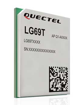
    Quectel Wireless Solutions Co. Ltd., in association with STMicroelectronics, has released the LG69T module, an automotive-grade dual-band high-precision GNSS module that integrates dead-reckoning (DR) and real-time kinematic (RTK) technologies.

    The new Quectel module, announced at 2019 Apsara Conference in Hangzhou, is designed to facilitate open-sky positioning performance with an accuracy of up to 10 centimeters, which is currently the industry’s most advanced positioning technology for the automotive market. LG69T will support next-generation precision positioning capabilities for smart vehicles and autonomous driving scenarios.

    The Quectel LG69T GNSS module is based on ST’s STA8100GA, the latest Automotive-grade dual frequency positioning chip with 80 tracking channels and four rapid-acquisition channels that are compatible with many constellations: GPS, BeiDou, Galileo, NAVIC/IRNSS and QZSS.

    It is an AEC-Q100-qualified dual-band (L1 + L5) GNSS module that integrates multi-band RTK technology for centimeter-level accuracy.

    The LG69T module’s dead-reckoning capabilities feature an integrated inertial measurement unit (IMU) that provides continuous high-precision positioning. The LG69T supports corrections input for standard Radio Technical Commission for Maritime Services (RTCM) and centimeter-level navigation by using RTCM data from a third — local base stations. The module performs well under the highly challenging conditions of urban canyon environments.

    “We are thrilled to collaborate with STMicroelectronics on our newest generation of high-precision positioning module,” said Min Wang, Quectel’s automotive product line general manager. “With this highly-integrated LG69T module, automakers and Tier 1 suppliers will no longer have to spend time selecting components, integrating hardware, adapting interfaces and conducting tests and verifications, which will greatly cut their time-to-market and costs, and help them accelerate the deployment of autonomous driving to seize early opportunities.”

    “ST has strong experience and is the Global Automotive High Precise Positioning Technology and Market Leader. We are very proud to cooperate with leading Chinese smart driving high technology company,” said MH TEY, Greater China, South Asia and Korea automotive marketing and application head of department, STMicroelectronics. “Today, there is growing dependency on high-performance GNSS in automotive applications such as navigation, safety and autonomous driving. With this cooperation, we are very confident to become the market leader by providing cost-effective and unique best-in-class solution for autonomous vehicle.”

    Engineering samples of Quectel’s LG69T module will be offered to automakers and Tier 1 suppliers by the end of 2019, and the product will be commercially available around mid-2020 and is expected to be deployed in mass produced models as early as 2021.

  • SXblue ToolBox Application now available on iOS

    SXblue ToolBox Application now available on iOS

    Image: SXblue
    Image: SXblue

    Following the launch of its Android application in 2018, Geneq is now launching an iOS version of its SXblue ToolBox for iOS-compatible SXblue devices.

    The application was developed with special interest paid to raw data recording and NTRIP service connection.

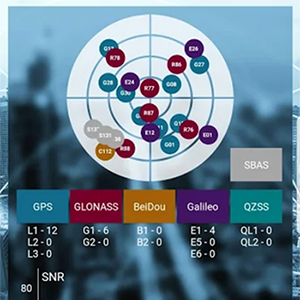
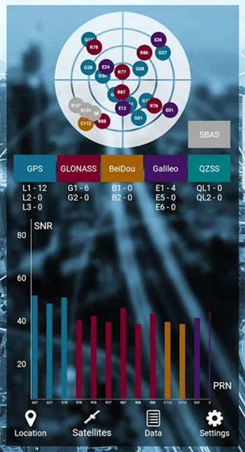
    With the SXblue ToolBox iOS application, the user can analyze the position data provided by the SXblue receiver, as well as location metadata.

    More important for SXblue clients, the application can record, save and transfer raw data from the GNSS receiver, thereby allowing post-processing activities. The application also acts as a NTRIP client, capable of connecting to a NTRIP server for real-time kinematic (RTK) corrections, and thus allows the receiver to issue very accurate location information.

    Receiver configuration is easy through the application, with the ability to set up and save user-defined commands for subsequent use. The settings include constellation to be used, differential source, NTRIP login credentials list and more.

    In addition, the iOS application includes a series of audible and visual alarms that are user-configurable to determine the thresholds of information provided by the SXblue GNSS receiver.

    The main features of the iOS SXblue ToolBox application are:

    • Display of location information and quality of positioning data
    • Skyplot of all-in-view constellations: GPS, GLONASS, Galileo BeiDou, QZSS, SBAS
    • Recording of raw data and data transfer
    • NTRIP/DIP client to receive RTK corrections
    • Terminal to send commands and view the output data of the SXblue device
    • Audible and visual alarms
    • Activation of options and licenses via the application.
  • RxNetworks extends Location.io service with BeiDou III support

    RxNetworks extends Location.io service with BeiDou III support

    Logo: Rx Networks

    Rx Networks Inc., as part of its continued reference network expansion and vendor diversity initiative, has added BeiDou III B1C and B2a signals and messages to Location.io, its feature-rich, modular location platform.

    BDS III is available via Location.io in a variety of data formats including regionally optimized, NTRIP, LPP and RRLP, as well as proprietary real-time and predicted formats.

    With the addition of BDS III, Location.io is positioned to support mobile devices globally in any configuration, including dual-band or single-band GNSS receivers, and in single or multi-constellation configurations.

    “Rx Networks continues to follow up on our promise to deliver Location. Enlightened. products and services,” said Peter Mueller, head of innovation at Rx Networks. “BDS will play a major role in the years to come with the uptake of multiband GNSS in mobile devices including smartphones and internet of things (IoT) devices.”

    “The upgrade and expansion of our private global reference network can now offer legacy BDS II signal B1I right up to PRN 63, in addition to the new BDS III B1C and B2a signals, as well as GPS/QZSS/Galileo/GLONASS/NavIC support in L1, L2c and L5/E5. Plus, our network is ready for Galileo E6. This makes Location.io one of the most complete data services available, all with a great Service Level Agreement.”

    BDS III will be part of the Location.io software client in early 2020.

    Location.io technologies are in use by more than 2 billion smartphones, laptops and wearables worldwide. All Location.io services are delivered from Rx Networks’ geo-redundant and cloud-based service delivery network, ensuring 99.999% service-level availability.

  • Trimble, Qualcomm partner on connected vehicle positioning

    Trimble, Qualcomm partner on connected vehicle positioning

    Companies aim to provide sub-lane-level accuracy to automotive OEMs and Tier 1 suppliers

    Image: Trimble
    Image: Trimble

    Trimble and Qualcomm Technologies, a subsidiary of Qualcomm Inc., will be working together to produce precise-positioning solutions for select automotive applications.

    Trimble will work with Qualcomm Technologies to integrate Trimble’s RTX technology with select Qualcomm Snapdragon Automotive 4G and 5G platforms to deliver a highly accurate positioning solution essential for maintaining absolute in-lane positioning.

    The new solution will accelerate the adoption of road-level navigation and emergency services applications, as well as satisfy requirements for developing advanced driver-assistance systems (ADAS) and autonomous driving solutions.

    The Snapdragon 4G and 5G automotive platforms feature integrated multi-frequency and multi-constellation high-precision GNSS technology. They also support all major global and regional GNSS satellite constellations including GPS, GLONASS, Galileo, BeiDou, and QZSS, operating concurrently on the L1, L2, and L5 frequency bands, including a precise positioning framework.

    The framework ensures consistency in access and use of precise positioning information and incorporates the use of GNSS corrections technology.

    Tight integration of GNSS functionality in conjunction with the modem reception of the corrections allows for minimum latencies and optimal performance of the precise-positioning solution from the telematics system and provides automakers with a global location platform to meet the requirements of next-generation vehicles.

    Trimble RTX technology provides real-time, multi-constellation GNSS corrections and positioning capable of achieving 2-centimeter horizontal accuracy worldwide, compared to uncorrected GNSS positioning that can be accurate to several meters. The combined solution will provide reliable, consistent, high-accuracy positioning, in a broadcast format, to serve even the most precise requirements of the automotive and transportation industries.

    “Trimble’s relationship with Qualcomm Technologies establishes a unique alliance between industry leaders, in which both companies are committed to advancing the development of safer, more capable ADAS,” said John Sprivulis, director of autonomous navigation solutions for Trimble’s advanced positioning division. “Together we will offer a solution to the automotive industry that can help accelerate the adoption of precise GNSS positioning in the connected car and transform the way the world drives.”

    “Highly accurate positioning is quickly becoming an important element of connected vehicle solutions to support Vehicle-to-Everything (V2X) and other autonomy applications,” said Lars Boeryd, senior director, product marketing, Qualcomm Technologies. “For this very reason, we are working with Trimble to host the RTX precise positioning software library on our Snapdragon Automotive 4G and 5G platforms to offer a robust end-to-end highly accurate position solution for the automotive industry.”

    Evaluation kit. An RTX-enabled Snapdragon evaluation kit (EVK) is expected to be available by early 2020, for use by automotive OEMs, Tier 1 suppliers or other stakeholders considering absolute positioning as part of their autonomy solution.

    Trimble has also made Trimble RTX Auto an ASIL and ASPICE compliant RTX software library, available to any OEM or supplier who requires a functional safety certified solution.

  • Qinetiq, Collins to develop GNSS receivers for UK

    Qinetiq, Collins to develop GNSS receivers for UK

    Photo: Collins Aerospace
    Photo: Collins Aerospace

    QinetiQ and its partner Collins Aerospace have won a £67 million contract with the United Kingdom’s Ministry of Defence (MOD) Defence Equipment and Support (DE&S) to develop multi-constellation satellite receivers under the U.K. Robust Global Navigation System (R-GNS) program.

    The program will deliver critical capability to provide UK Defence with accurate and resilient positioning, navigation and timing (PNT), which will underpin the UK’s ability to undertake 24/7 military operations around the world in demanding and increasingly contested operational environments.

    QinetiQ, working with its partner (Collins Aerospace) and sub-contractors (Roke Manor Research, Raytheon Systems Limited, Garfield Microelectronics, Nottingham Scientific Limited, Phixos and a number of other specialist suppliers and manufacturing partners) will work together to provide advanced navigation products that are UK sovereign supplied, low size, weight and power (SWAP) delivering high-accuracy, resilient and secured operational capability.

    The use of multi-constellation, multi-service satellite navigation signals, multiple sensors and QinetiQ’s advanced processing technologies will enable secured navigation, ensuring that users and platforms —autonomous land, maritime, air and weapons systems — will be able to navigate accurately, robustly and safely.

    “Whether it’s soldiers conducting operations in remote environments or fighter jet pilots flying in contested airspace, our Armed Forces depend on satellite navigation technology,” said Defence Minister Anne-Marie Trevelyan. “These state-of-the-art receivers will help to ensure our armed forces can defend UK interests wherever and whenever they are threatened.”

    “Ensuring that UK Forces have the best and most resilient secured navigation capabilities is essential to ensuring that they are able to operate effectively in increasingly challenging operational environments,” Steve Wadey, CEO, QinetiQ said. “We are extremely pleased to be working with MOD, DE&S and DSTL to deliver this critical capability. This programme will exploit QinetiQ’s advanced technologies and, working collaboratively with our partners across the supply base, deliver substantial operational advantage for UK Defence.”

    The delivery date for the first R-GNS products is February 2022.

  • Digital Matter’s battery-powered GPS receiver gets PTCRB approval

    Digital Matter’s battery-powered GPS receiver gets PTCRB approval

    Photo: Digital Matter
    Photo: Digital Matter

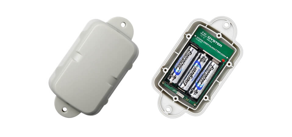
    Digital Matter’s Oyster2 4G battery-powered GPS receives PTCRB approval, AT&T certification and redesigned housing

    Digital Matter’s Oyster2 is now PTCRB approved and certified for use on the AT&T Network in the United States. With PTCRB certification, operators and device manufacturers are confident of a device’s interoperability with mobile networks.

    Designed for tracking non-powered assets for extended periods of time, common applications of the Oyster2 include tracking trailers, bins, hire and rental equipment, shipping containers, boats, bikes, scooters and more.

    The Oyster2’s u-blox SARA-R410M modem operates on all major global LTE-Cat-M1 and NB-IoT bands. The device uses concurrent GPS and GLONASS tracking with a 72-channel high sensitivity receiver, and features a 3D accelerometer for G-force detection.

    Configurable adaptive-tracking parameters allow the device to sleep when stationary, resulting in industry-leading battery life: up to seven years of life at once daily updates; one year of life at once hourly updates.

    The versatile asset tracker can be powered by three off-the-shelf AA lithium batteries, or lithium thionyl chloride (LTC) batteries for enhanced performance and temperature tolerance.

    The Oyster2 is now also available in redesigned ultra-rugged housing. Engineered with nylon glass, the IP67 housing is considerably tougher and thicker in key areas, providing increased durability, thermal resistance (the device can reach temperatures up to 185º F/85º C without compromising performance) and chemical resistance.

    The device’s mounting tabs and screw holes have also been fortified and repositioned, improving resistance to cracking.

    Digital Matter is an original equipment manufacturer of award-winning GPS and internet of things (IoT) devices and tracking software. Digital Matter devices are resold through 500 channel partners across the world and deployed in more than 110 countries.

  • GPS-based portable JPALS landing system sets up fast

    GPS-based portable JPALS landing system sets up fast

    Raytheon’s F-35 precision landing system can be set up anywhere in less than 1.5 hours

    A Raytheon Company team has conducted a rapid set-up demonstration of a land-based expeditionary version of its Joint Precision Approach and Landing System (JPALS) to a group of global military officials at Naval Air Station Patuxent River, Maryland.

    JPALS is a GPS-based precision landing system that guides aircraft to precision landings in all weather and surfaces conditions.

    “The entire system was fully operational in 70 minutes on Day One and 50 minutes on Day Two,” said Matt Gilligan, vice president at Raytheon’s Intelligence, Information and Services business. “Raytheon is offering the U.S. and its allies fast and accurate precision landing systems that support operations from bare-base locations.”

    During the demonstration, military officials from all four services, as well as representatives from Japan, United Kingdom, The Netherlands and Italy, watched multiple F-35Cs land on the same designated runway landing point every time over the course of six different approaches.

    This was the second proof-of-concept event in 2019 showing how F-35s can use a reconfigured mobile version of JPALS to support landings in austere environments.

    JPALS is a differential, GPS-based precision landing system that guides aircraft onto carriers and amphibious assault ships in all weather and surface conditions up to the rough waters of Sea State 5. It uses an encrypted, jam-proof data link to connect to software and receiver hardware on the aircraft and an array of GPS sensors, mast-mounted antennas and shipboard equipment.

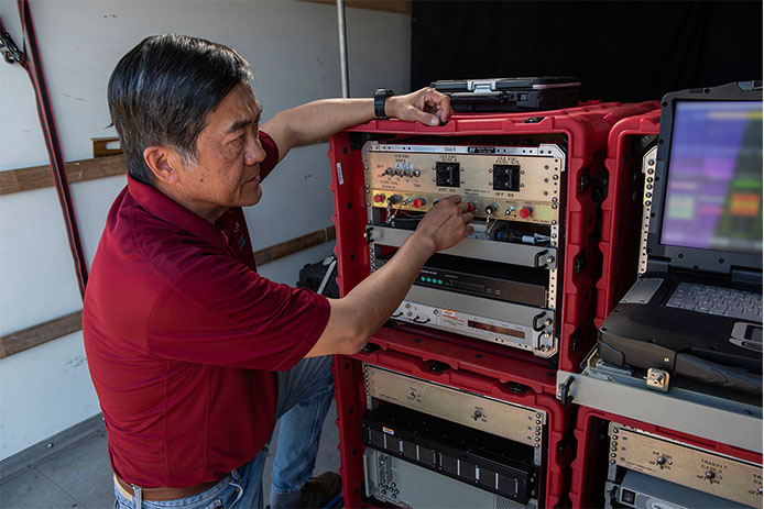
    A Raytheon technician operates the rapidly installed JPALS equipment during a demonstration at the Naval Air Station. (Photo: Raytheon)
    A Raytheon technician operates the rapidly installed JPALS equipment during a demonstration at the Naval Air Station. (Photo: Raytheon)