Category: Applications

  • Septentrio, Artisense demo localization tech for autonomous vehicles

    Septentrio, Artisense demo localization tech for autonomous vehicles

    High-precision GPS, INS and computer vision come together in a single package called VINS to be demonstrated at the Auto.ai show in Berlin on Sept. 25-27.

    Septentrio high-performance GPS/GNSS technology provides reliable absolute positioning inside this innovative computer vision localization system developed by Artisense, a company specializing in vehicle localization and 3D mapping solutions.

    Septentrio, a manufacturer of high-accuracy GPS/GNSS technology for demanding applications, is providing positioning technology to Artisense, a supplier of computer vision solutions for automated vehicles.

    Artisense incorporates Septentrio GPS/GNSS in their latest visual inertial navigation system (VINS), which will be demonstrated live at Auto.ai show in Berlin, Germany, on Sept. 25-27.

    VINS combines computer vision, inertial sensors and GNSS (Global Navigation Satellite System) measurements to deliver highly accurate global 3D positioning and orientation information in any environment, even indoors.

    “We are very pleased to work with Artisense on this technology and demonstrate how vehicle localization systems benefit from fusing computer vision with high-precision GNSS,” said Jan Van Hees, business development director at Septentrio. “The result of our cooperation is precise localization in any environment offering positioning reliability and redundancy needed for safety-critical applications such as autonomous vehicles or robotics.”

    Multi-constellation, multi-frequency GNSS technology provides reliable centimeter-level global positioning to the VINS system with accuracy required for lane-level maneuvering and V2V warning systems.

    Cameras and inertial sensors continue accurate localization as the vehicle moves into tunnels or parking garages with no line-of-sight to GNSS satellites.

    Although the system uses a relatively simple MEMs IMU and off-the-shelf cameras, it delivers precision and reliability of a high-end INS system. “Positioning accuracy and reliability are very important to us. Earlier this year we have deployed a large-scale mapping operation in Berlin where we tested a lot of different GNSS receivers. We saw the best results coming from Septentrio consistently,” said Johannes Start, Technical Product Manager at Artisense. “We continue to use Septentrio receivers because they are precise, they acquire RTK (real-time kinematic) fix quickly and reliably and they are easy to integrate.”

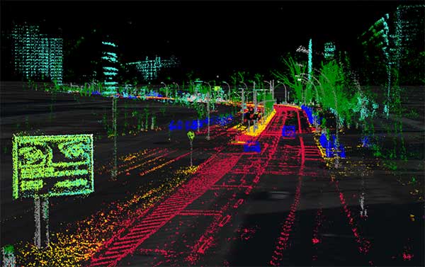
    The live demo at Auto.ai will offer a ride around Berlin in a car featuring VINS technology. One screen inside the car will continuously display the car’s location. Unlike the GPS of an average infotainment system, VINS will continue accurate localization anywhere, even in tunnels or in parking garages. The second screen inside the car will feature a real-time 3D point-cloud reconstruction of the car’s surroundings.

  • RX Networks announces NavIC support

    RX Networks announces NavIC support

    Rx Networks logo

    Rx Networks Inc., a mobile location technology and services company, has announced support for the NavIC Constellation.

    The company made the announcement at ION GNSS+, held earlier this month in Miami, Florida.

    Rx Networks’ comprehensive GNSS constellation data service provides technology partners — and their associated customers — real-time and predicted assistance for all satellite navigation systems and L1 satellite-based augmentation systems (SBAS) for any region around the globe.

    The addition of NavIC builds on Rx Networks’ brand promise (to deliver “location enlightened” products and services) by providing real-time and predicted GNSS assistance data in any individual or combination of formats. This enables developers to optimize device performance for specific use cases and conform to national requirements.

    Data is delivered via ephemeris in RINEX and Predictions in SP3, P-GNSS and RT-GNSS, via the Location.io platform, will be added in the first quarter of 2020.

    “Our Location. Enlightened. brand promise speaks to our goal of providing the most comprehensive, relevant, accurate and reliable location data available,” said John Carley, vice president of sales and marketing at Rx Networks. “The addition of NavIC in our carrier-grade infrastructure demonstrates our commitment to our brand and to stay on the leading edge of truly global satellite-based positioning and services. The ability to offer NavIC support is extremely significant as it ensures we can support our customers with exactly what is required in any given region of the Globe.”

    NavIC, formerly known as IRNSS (Indian Regional Navigation Satellite System), combines GEO and IGSO satellites to provide a regional position, navigation and time (PNT) system including ionospheric corrections.

  • PCTEL unveils GNSS L1/L2/L5 combo antenna at RSSI

    PCTEL unveils GNSS L1/L2/L5 combo antenna at RSSI

    Photo: PCTEL
    Photo: PCTEL

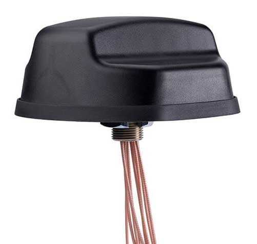
    PCTEL Inc. has released an antenna that combines precision multi-constellation GNSS with high-performance LTE, sub-6 GHz 5G, Bluetooth and Wi-Fi connectivity.

    The Coach II antenna with GNSS L1/L2/L5 is designed to provide greater precision and reliability for advanced rail communications systems, enabling everything from next-generation positive train control (PTC) to passenger Wi-Fi.

    “Precise timing and tracking information is critical not just for rail, but for a variety of fleet, public safety, and industrial IoT [internet of things] applications,” said Rishi Bharadwaj, PCTEL’s chief operating officer. “PCTEL’s antenna technology enables our customers to deploy new technologies with confidence,” added Bharadwaj.

    The new antenna features:

    • Global multi-GNSS compatibility: 1150-290 MHz (GPS L2/L5; Galileo E5A/E5B/E6; GLONASS L2/L3; BEIDOU B2/B3); 1500-615 MHz (GPS L1; Galileo E1; GLONASS L1; BEIDOU B1/B1-2)
    • Dual-port 4G LTE / sub-6 GHz 5G NR
    • 802.11ac Wi-Fi / Bluetooth connectivity
    • AAR compliant for railway applications
    • IP67-rated design

    PCTEL is displaying its Coach II antenna with GNSS L1/L2/L5 on Sept. 22-24 at RSSI C&S Exhibition in Minneapolis, Minn. It is available to order now for shipment in early November using part #GL125-DLTEMIMO.

  • Live from Intergeo 2019

    Live from Intergeo 2019

    Logo: Intergeo 2019The GPS World staff reported live from Intergeo Sept. 17-19 in Stuttgart, Germany. The massive trade show, dubbed the “global hub of the geospatial community,” brings together more than 19,000 visitors from more than 114 countries and features approximately 640 exhibitors. Check out the latest industry news, as well as photos and videos from the event.

    News

    Videos

    Click the icon in the top right hand corner to choose the video you’d like to watch.

    Resources

    Past Coverage


    Featured photo: Allison Barwacz

  • Orolia Defense & Security completes acquisition of Talen-X

    Orolia Defense & Security completes acquisition of Talen-X

    Talen-X has joined Orolia Defense & Security to expand its capabilities and resources, enabling the development of more advanced position, navigation and timing (PNT) solutions and to offer more robust customer support.

    Photo: Orolia

    Orolia Defense & Security has completed the acquisition of Talen-X, a U.S. company specializing in advanced GNSS solutions and interference, detection and mitigation (IDM) technologies.

    “Orolia Defense & Security is excited to bring on Talen-X as they offer a complementary portfolio of solutions and bring many years of advanced PNT experience to the team. We look forward to continuing their growth by providing additional resources and capabilities, while ensuring the growth and success of their current customers,” said Hironori Sasaki, president of Orolia Defense & Security.

    In early 2019, Orolia Defense & Security spun off as a separate entity from its parent company Orolia, with the mission of providing resilient PNT solutions and custom engineering services to U.S. government agencies, U.S. defense organizations, and their contractors.

    Orolia Defense & Security operates as a proxy-regulated company, free of foreign ownership, control or influence (FOCI). As such, Orolia Defense & Security is approved to work on the full spectrum of U.S. government classified and unclassified projects and is positioned to support strategic partnerships in the development of key PNT technologies for the defense market.

    “Our culture of innovation, together with our demonstrated testing capabilities, will complement Orolia’s technology expertise and significantly enhance the reliability, performance and safety of military operations,” said Tim Erbes, Orolia Defense & Security’s Director of Engineering. The acquisition also enables Talen-X’s existing resources, operations and capabilities to be scaled and accelerated to better support the warfighter.

    At the Modern Day Marine and Association of the U.S. Army (AUSA) exhibitions, Orolia Defense & Security is showcasing its latest technologies such as the BroadSim Wavefront GNSS simulator, ThreatBlocker jamming/spoofing detection and protection device and BroadShield threat detection software.

    Authorized for use with U.S. military signals such as GPS L1/L2, P, Y, and M-Code, Orolia’s simulation and IDM solutions serve unique and challenging program requirements.

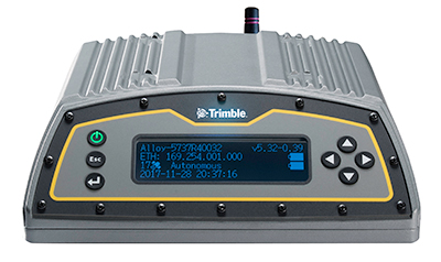
  • Trimble Pivot, Alloy GNSS receiver now support BDS-3 signals

    Trimble Pivot, Alloy GNSS receiver now support BDS-3 signals

    Photo: Trimble
    Photo: Trimble

    Trimble has added capabilities to its real-time network (RTN) portfolio, including the Trimble Pivot Platform and the Trimble Alloy GNSS reference receiver.

    The new capabilities will enable operators to continue to meet the ongoing demand from surveyors, mapping professionals and precision farmers for accurate, reliable corrections derived from real-time networks.

    The announcement was made at Intergeo 2019, the world’s largest conference on geodesy, geoinformatics and land management, taking place Sept. 17-19 in Stuttgart, Germany.

    Boosting RTN performance. A well-established network software, the Pivot Platform manages and controls small, mid-size and countrywide GNSS networks. By applying sophisticated atmospheric models to reduce systematic errors, highly accurate GNSS corrections are generated and made available for a wide range of field applications.

    BDS-3 now supported

    Both Pivot and Alloy now access BeiDou Generation III (BDS-3) signals.
    Trimble Pivot version 4.3 has been enhanced to track and store BDS-3 — RTN operators worldwide now have the ability to provide their customers with additional satellite signals to offer even more robust and reliable positioning for their applications. This update also includes a simplified Chinese user interface, providing easy-to-use software operations for Chinese RTN operators.

    Released in 2018, the Alloy GNSS reference receiver was designed with the processing power needed to deliver high-quality data from multiple GNSS constellations. Alloy version 5.42 firmware tracks all available and planned GPS Block IIIA L1C and BDS-3 signals, empowering operators with a full GNSS constellation dataset.

    “These updates keep the Trimble Pivot Platform and Alloy on a future driven path,” said Mark Richter, strategic marketing director, Real-Time Networks and Services portfolio for Trimble’s Advanced Positioning Division. “Our focus is to continue to deliver enhancements influenced by market demands and advancements in technology, which deliver next-generation RTN hardware and software to our customers.”

    The Trimble Pivot Platform and Trimble Alloy GNSS reference receiver updates work in conjunction to provide quality GNSS corrections to network operators and end users.

    Trimble real-time networks and services

    Trimble RTN networks and services are a widely used GNSS infrastructure solution. Spanning a variety of applications and industries worldwide, Trimble’s hardware is specifically developed for RTN real-world environments while the software integrates seamlessly into the RTN solution for exceptional real-time performance.

    The flexibility of Trimble’s solution enables users to collect, manage and analyze complex information faster and easier, improving productivity and efficiency.

  • Trimble handheld AR SiteVision takes data visualization outdoors

    Trimble handheld AR SiteVision takes data visualization outdoors

    Photo: Trimble
    Photo: Trimble

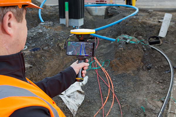
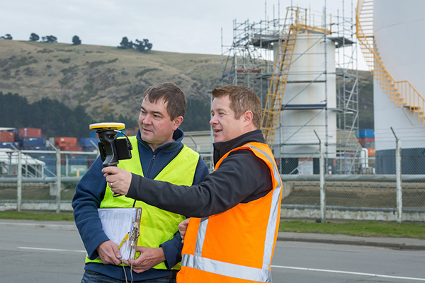
    Trimble has introduced its Trimble SiteVision system, an outdoor augmented reality (AR) solution that enables users to visualize 2D and 3D data on virtually any project site with cellular or internet connectivity for easier and more efficient planning, collaboration and reporting.

    Combining hardware and software in an integrated, lightweight handheld or pole-mounted solution, users can view 3D models and assets in a real-world environment at a 1:1 scale, from any angle or position.

    The system consists of:

    • Hardware: The Trimble SiteVision integrated positioning system integrates the Trimble Catalyst DA1 antenna, electronic distance measurement (EDM) rangefinder and power management into a lightweight, handheld device that connects to a user-supplied Android mobile phone.
    • Software Subscription: Available to single users on a monthly or yearly basis. The SiteVision software subscription combines Trimble’s high-accuracy positioning services and cloud-based processing technology to create a centimeter-accurate AR system. The system leverages Trimble cloud-based processing to manage and deliver data and design models.


    SiteVision enables users to visualize digital models from a wide range of data collection, design and constructible modeling tools in open industry-standard formats including IFC and LandXML.

    For civil projects, SiteVision accurately visualizes data from Trimble’s Quantm, Business Center and Novapoint; design data from Civil 3D and Bentley OpenRoads; and GIS data from Esri ArcGIS software.

    Photo: Trimble
    Photo: Trimble

    SiteVision powers building information modeling (BIM) projects with open data from Trimble’s Constructible BIM solutions including SketchUp and Tekla, and BIM data from Autodesk Revit and AutoCAD software. For utility companies, PLS-CADD power line design, Distribution Design Studio (DDS) and other industry-specific design data is also supported.

    Using Trimble Connect cloud-based hosting, SiteVision can access models from all stages of the lifecycle of infrastructure and buildings—from initial concepts of roads or buildings through the operations and maintenance phase of the assets—to increase collaboration, enhance work accuracy and ultimately improve operations and utilization.

    SiteVision simplifies complex concepts by allowing users to blend digital content with real-world environments. For example, city planners can visualize a new building design in the exact spot it is to be erected, a work crew could identify the exact position of underground cables or pipes before digging, an electric utility can confirm placement of poles and lines with customers and crews, or a construction supervisor could assess the progress of heavy equipment by visualizing actual work performed against the site plan.

    “It’s easier to understand complex ideas when we can see them in a real-world context,” said Mark Nichols, general manager at Trimble. “SiteVision improves our understanding of projects and worksites with a handheld device that is accessible to a wide range of users. Augmented reality is now ready for everyday use in a wide range of applications.”

    Trimble SiteVision is available to order now through Trimble’s authorized distribution channels for Civil Engineering and Construction, Geospatial and Buildings.

  • Bluesky debuts MetroVista city mapping service for Europe at Intergeo 2019

    Bluesky debuts MetroVista city mapping service for Europe at Intergeo 2019

    The Bluesky MetroVista range includes high-resolution imagery combined with high-accuracy, wide-scale 3D models. (Image: Bluesky)
    The Bluesky MetroVista range includes high-resolution imagery combined with high-accuracy, wide-scale 3D models. (Image: Bluesky)

    Bluesky International has launched its international MetroVista city mapping service for Europe at Intergeo 2019, which took place Sept. 17-19 in Stuttgart, Germany.

    The mapping service incorporates the Leica CityMapper hybrid airborne sensor, which can simultaneously capture vertical and oblique aerial photography, as well as lidar.

    According to the company, the Bluesky MetroVista range includes high-resolution imagery combined with high-accuracy, wide-scale 3D models. Bluesky’s CityMapper also has already been used to capture MetroVista data for cities across the United Kingdom, including London, Manchester, Newcastle and Bristol.

    Bluesky’s CityMapper, used to produce the MetroVista data, includes a traditional vertical camera, as well as survey-grade oblique cameras. The sensor, designed for 3D city modeling and urban mapping, incorporates lidar technology to accurately collect elevation and infrared data.


    “Here at Intergeo, we’re showing our MetroVista data sets, which are the city meshes,” Ralph Coleman, sales director at Bluesky, told GPS World. The city meshes are extremely dense, they’re very feature-rich, and they’re vey accurate. They provide a vast range of detail for a massive range of applications.”

    Bluesky is a United Kingdom-based aerial survey and geographic data company that produces and maintains digital aerial photography and height data. The company has offices in the United Kingdom, United States and the Republic of Ireland, as well as a production center in India.

  • Trimble launches X7 3D laser scanner at Intergeo 2019

    Trimble launches X7 3D laser scanner at Intergeo 2019

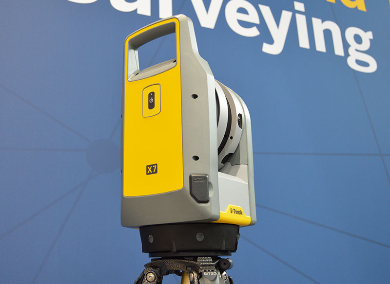
    The Trimble X7 is designed for surveying, construction, industrial and forensic applications. (Photo: Allison Barwacz)
    The Trimble X7 is designed for surveying, construction, industrial and forensic applications. (Photo: Allison Barwacz)

    Trimble has released its X7 3D laser scanning system at Intergeo 2019, which took place Sept. 17-19 in Stuttgart, Germany. According to the company, the system is designed to enable professionals of all scanning levels to quickly and easily capture precise 3D scanning data to produce high-quality deliverables.

    The X7 is designed for surveying, construction, industrial and forensic applications. The scanner features Trimble X-Drive technology, survey-grade self-leveling and a smart calibration system.

    “We are really excited to bring the X7 to the market,” Gregory Lepere, marketing director, optical and imaging, Trimble, told GPS World. “It’s a very simple solution but offers a lot of smart technology. Every time you turn the instrument on, the automatic calibration will start, so you’re guaranteed to have all of the specifications all of the time.”

    It also integrates streamlined workflows to provide automatic registration of point cloud data in the field with Trimble Registration Assist.

    “The feature bringing the most simplicity to the solution is the Trimble Registration Assist technology, which is a full registration in the field, bringing all of the scans together thanks to self-leveling IMU technologies combined with cloud-based software,” Lepere said.


    Survey applications

    For surveyors and geospatial professionals, the X7 provides fast and balanced performance in both indoor and outdoor environments and is ideal for industrial survey/tank calibration, civil infrastructure, general surveys, road intersection surveys, utilities, mining, and historical documentation and renovation, Trimble said.

    The X7 is fully integrated with the Trimble Perspective software, which enables scans and images to be captured, fully registered together, refined, controlled and exported to a variety of established data format for Trimble and non-Trimble software suites.

    Building design and construction applications

    For users in building design and construction, the X7 assists with measurement problems and improves field productivity for a broad range of applications in architecture, engineering and construction industry projects.

    For these applications, the X7 is fully integrated with Trimble Field Link software to provide streamlined workflows specific to the building construction industry — from scanning to modeling to field layout.

    Forensics applications

    According to Trimble, the X7 can perform in demanding conditions and offers easy setup for investigators and law enforcement. It also pairs with the company’s Trimble Forensics Capture software.

    The Trimble X7 is expected to be available in the first quarter of 2020.

    In addition, the company announced the availability of its SiteVision augmented reality system at Intergeo.

  • Septentrio GNSS receivers to guide train systems for Wabtec

    Septentrio is providing GPS/GNSS receivers to Wabtec, a global company specializing in equipment, digital solutions and services for freight and transit rail systems.

    Wabtec is implementing Septentrio GNSS receivers in its GoLINC Edge platform, providing positioning, connectivity, data storage and enhancing positive train control (PTC) with the adoption of higher precision positioning technology.

    The enhanced navigational reference capability can benefit U.S. railroad operations as Septentrio GNSS receivers are installed on Wabtec’s latest GoLINC mobile data center platform operating onboard freight locomotives. Two GNSS receivers are being installed on each locomotive to provide precise positioning information as part of the GoLINC system.

    Septentrio receivers are also being installed as position reference modules along 30,000 miles of track. They will provide GNSS corrections to the rover receivers aboard the locomotives for reliable and accurate positioning, even in difficult environments such as when tracks run alongside mountains, around cliffs or under foliage.

    “The Septentrio GNSS receiver was chosen based upon its superior performance and has proven to have the technology advantage that our customers are looking for,” said Michael Miner, GoLINC product manager at Wabtec.

    Wabtec’s GoLINC system — comprising networking, communications and applications management platforms — makes trains smarter by collecting numerous parameters about the train and its route.

    GoLINC is integrated with Wabtec’s PTC solution, which functions as a safety overlay and is designed to enforce existing railroad signal indications and other operating rules. Moreover, PTC provides critical information about proximity of work zones, movement authorization, switch positions and other operational data.

    “For two decades, Septentrio has been delivering GNSS receivers to customers requiring accuracy, reliability and safety,” said Neil Vancans, Septentrio vice president of global sales. “We have pioneered and fine-tuned capabilities such as position reliability and interference robustness driven by our customers in markets such as offshore energy, mining and construction.

    “Over the last several years, we have been working closely with the transportation and logistics sector as well,” Vancans said. “Cooperation with Wabtec offers an excellent opportunity to further deploy our high-precision positioning technology in the rail industry, where the unique capabilities of our GNSS hardware and software match perfectly with the accuracy and safety demands of positive train control.”

    Beyond PTC, the high-precision GPS infrastructure along the track will enable other applications such as drone flights for rail inspection.

    Septentrio will be exhibiting its latest GNSS receivers at the Railway Interchange exhibition and technical conference, which runs Sept. 22-25 in Minneapolis, Minn., USA.


    Feature photo: Septentrio

  • CHC Navigation’s new i90 GNSS receiver improves RTK

    CHC Navigation’s new i90 GNSS receiver improves RTK

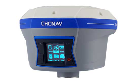
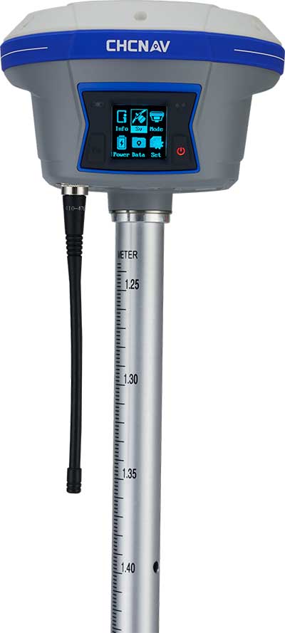
    Photo: CHC Navigation
    Photo: CHC Navigation

    CHC Navigation has released and is immediately shipping its new i90 IMU-RTK GNSS Series receiver. The i90 IMU-RTK GNSS Series is designed to dramatically increase GNSS real-time kinematic (RTK) availability and reliability.

    The i90 is powered by the company’s latest inertial measurement unit (IMU) and RTK technology to provide robust and accurate GNSS positioning in any circumstances.

    Unlike standard micro-electro-mechanical (MEMS)-based GNSS receivers, the i90 GNSS IMU-RTK combines a high-end calibration and interference-free IMU sensor with a state-of-the-art GNSS RTK engine and advanced GNSS tracking capabilities.

    The i90 is designed to increase productivity and reliability of survey projects. No complicated calibration process, rotation, leveling or accessories are necessary with the i90 GNSS Series. Just a few meters’ walk will initialize the i90 internal IMU sensor and enable RTK survey in difficult field environments. The i90 GNSS automatic pole-tilt compensation boosts survey and stakeout speed by up to 20%.

    “Our new i90 IMU-RTK GNSS Series is pushing the boundaries of conventional GNSS survey by extending RTK positioning availability and reliability,” said George Zhao, CEO of CHC Navigation. “CHCNAV is the GNSS technology enabler, making high-end GNSS solutions available for every surveyor.”