Category: Applications

  • PNT Board opposes Ligado ‘lite’ proposal, DARPA seeks photonics

    PNT Board opposes Ligado ‘lite’ proposal, DARPA seeks photonics

    On Aug. 10, the National Space-Based Positioning, Navigation, and Timing (PNT) Advisory Board, the government’s GPS expert board, sent a letter to the National Executive Committee for Space-Based PNT (a multi-agency body that steers GPS policy) that concluded, “We strongly recommend your opposition to the Ligado proposal.”

    The letter sprang from a unanimous vote five days earlier to oppose allowing Ligado Networks to use spectrum neighboring the GPS band for terrestrial communications.

    Ligado possesses licenses to broadcast on two satellite bands located adjacent to the GPS frequencies. The company has been seeking permission from the Federal Communications Commission (FCC) to repurpose these licenses from satellite-based use to ground-based use from powerful tower transmitters.

    Ligado said in May it would lower the power in its proposal for the 1526–1536 MHz band to 9.98 dBW to avoid interference with certified aviation receivers. However, the PNT Advisory Board reiterated its opposition, saying that even if the transmissions’ power was lowered to just under 10 watts, it “will create totally unacceptable interference for a great number of GPS users in the United States.”

    From the Letter: “This risk is far too great, and far too many questions remain, for Ligado’s proposal to be approved. While there are many broadband alternatives (Ligado would be a very small percentage of this national asset), there is only one GPS. Any impairment to current and future uses is clearly contrary to the national interest. Therefore, implementation of their recently proposed ~10-watt operating scheme will create totally unacceptable interference for a great number of GPS users in the United States. In fact, despite power limits in their current amended application, it is probable they could still be allowed to increase this power over time. This would be even more destructive to GPS users.

    “We believe avoiding degradation over at least 90 percent of the region near Ligado transmitters is the absolute minimum protection for GPS receivers in each class. This would be a hypothetical 90 percent Protection Evaluation. This is not an endorsement of this level since, of course, all users would prefer 100 percent protection. The Department of Transportation (DOT) Adjacent Band Compatibility (ABC) study is the only validated test to verify degradation at various received power levels.

    “Those results inform that to insure degradation not exceed 10 percent of the Region (90 percent Protection) for High Performance receivers, either:

    Ligado maximum power can be no more than .0036 watts at the 400-meter spacing they had earlier planned. Tolerable power would be 3/10ths of 1 percent of their proposed ~10 watts. Or

    the closest spacing of Ligado transmitters is 20,000 meters (over 12 miles) for their proposed ~10 watt power level (see Figure 1).”
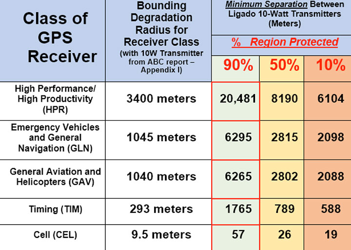
    Figure 1. The PNTAB strongly believes that 90% is the minimum Area Protection Criterion (maximum 10 % degradation). (Chart: PNT Advisory Board)
    Figure 1. The PNTAB strongly believes that 90 percent is the minimum Area Protection Criterion (maximum 10 percent degradation). (Chart: PNT Advisory Board)

    DARPA wants photonic integrated circuits

    High-energy photons emission (abstract illustration). (GiroScience/Shutterstock.com)
    High-energy photons emission (abstract illustration). (Photo: GiroScience/Shutterstock.com)

    The U.S. Defense Advanced Research Projects Agency (DARPA) Microsystems Technology Office is soliciting research proposals for the development of a new class of atom-based systems using integrated photonics and trapped atoms to enable high-performance, robust, portable clocks and gyroscopes.

    The military researchers are asking industry to develop relatively simple portable photonic integrated circuits (PICs) for high-performance position, navigation and timing (PNT) devices as an alternative to GPS for when satnav signals are not available.

    A PIC or integrated optical circuit, similar to an electronic integrated circuit, integrates multiple photonic (having to do with light) functions, providing capabilities for information signals imposed on optical wavelengths, typically in the visible spectrum or near-infrared, 850–1650 nanometers.

    A-PhI Program

    The Atomic-Photonic Integration (A-PhI) program seeks to develop trapped-atom based, high-performance PNT devices, reducing the complexity of these atomic systems by using PICs. According to the DARPA document, the PICs will replace the optical assembly behind devices such as sensitive and accurate angle sensors and clocks, while still enabling the necessary trapping, cooling, manipulation and interrogation of atoms.

    A-PhI aims to demonstrate that compact PICs can replace the optical bench of conventional free-space optics for high-performance trapped-atom gyroscopes and trapped-atom clocks without degrading the performance of the underlying physics package.

    Physics

    Atomic systems using trapped atoms have the potential to be made portable while maintaining their accuracy due to the atomic trap’s small size and the inherent isolation a trap offers an atomic system from the environment, especially from acceleration.

    Currently, these systems are bulky, heavy, and not notably portable, because of the complexity of the optical systems used to create the trap.
    In the past, efforts to miniaturize the hundreds to thousands of optical components in such benchtop systems have relied on removing optical elements, miniaturizing the remaining elements, and tightly integrating them in a small package.

    The products deliver degraded performance with the need to maintain very tight optical alignment, causing both poor environmental robustness and poor tolerance to design errors. Effective miniaturized atomic systems cannot be achieved at a reasonable cost with this approach.

    Recent developments in PIC research suggest that on-chip optical frequency combs based on microresonators, optical frequency synthesis, novel on-/off-chip coupling, wavelength demultiplexers, and on-chip phased arrays for dynamic manipulation of light fields can replace optical systems with readily manufacturable, low-cost chips without the alignment sensitivity of conventional free-space optics.

    Gyroscopes

    A-PhI also seeks to develop proof-of-concept trapped atom gyroscopes, a matter-wave analog of the interferometric fiberoptic gyroscope. Such a miniaturization effort could generate an order of magnitude improvement in angular sensitivity and dynamic range over current free-space products.

    A-PhI hopes to develop portable, high-performance, navigation and timing systems: the miniaturization of the optics of atomic systems without a decrease in performance. Subsequent work, the RFP asserts, will be required to incorporate the necessary compact and robust lasers and electronics to achieve a fully functioning, high-performance, portable PNT system.


  • STATS GPS provides coaches with instant performance feedback

    Image: STATSports
    Image: STATSports

    Sports data company STATSports is offering STATS GPS shirts to provide real-time GPS intelligence to athletes and coaches.

    Wearing STATS GPS shirts, teams can monitor player metrics such as accelerations/decelerations, energy expenditure and count of zone entries, as well as time, distance and power thresholds.

    The system uses a 50-Hz sampling frequency. It allows practitioners to monitor up to 100 players in real time and post session with more than 300 GPS, inertial measurement unit (IMU) and HR-derived metrics, the company said.

    The shirts feature an embedded medical-grade ECG sensor that’s fully integrated with the GPS units, allowing for seamless real-time analysis with the STATS Dynamix online portal.

    Customizable reports can include information on imbalance, cardiovascular metrics and running, explosive and brake symmetry.

  • Excavator makers provide smart options

    Excavator makers provide smart options

    The JCB 220X Excavator at work. (Photo: JCB)
    The JCB 220X Excavator at work. (Photo: JCB)

    Makers of heavy construction equipment are enabling their latest models to become smarter.

    Topcon Positioning Group and JCB are collaborating to provide the Topcon X-53x as a plug-and-play option for the new JCB 220X crawler excavators — the first models in the next generation of JCB tracked machines for the global construction market.

    The new excavators come with a Topcon pre-wire option from the factory. The Topcon X-53x is designed to provide precise positioning of the boom, stick and bucket at all times, maximizing output up to 30 percent more than machines without a 3D system, the company said. The X-53x also provides a customizable machine control platform to address future project demands.

    Also, Topcon and Volvo CE have established a system to allow Topcon 3D machine control software (3D-MC) to seamlessly integrate with the Volvo CE Dig Assist system for a large range of excavators.

    The integration of 3D-MC software is designed to complement the Dig Assist real-time guidance capability by including the use of 3D design files and connectivity with Topcon workflow solution platforms. Topcon 3D-MC can be added as an app on the Co-Pilot platform to connect the machine to the Topcon ecosystem.

    Meanwhile, Kobelco Construction Machinery has introduced a Trimble-ready option for select excavator models that ship from the Kobelco factory. The excavators come ready for installation of the Trimble Earthworks Grade Control Platform, reducing the cost and complexity of installation for the contractor. Other Kobelco models released this year will also provide the Trimble-ready option.

    Doosan Infracore is offering a Trimble-ready option for its Doosan DX225LC-5 excavator, enabling faster, simplified installation of Trimble’s GCS900 2D or 3D Grade Control System components with no welding, re-painting, drilling or disassembly required.

    Trimble GCS900 makes design surfaces, grades and alignments accessible to the operator on a display inside the cab using GNSS, GPS, laser, sonic or total station technology to accurately position the blade or bucket in real time.

  • Moving mountains: Alps researchers detect a decade of movement

    GPS data serves as the basis for a geodetic model of the Alps. Here, a horizontal strain field is derived from the data. Red areas indicate compression; blue indicates lateral spreading. (Image: DGFI-TUM)
    GPS data serves as the basis for a geodetic model of the Alps. Here, a horizontal strain field is derived from the data. Red areas indicate compression; blue indicates lateral spreading. (Image: DGFI-TUM)

    Our Earth is constantly on the move, as the current Kilauea eruption dramatically illustrates. But capturing data on small shifts over time isn’t so easy.

    A new computer model based on more than a decade of GPS data shows the dynamic movements of the Alps as the mountain range drifts and rises.

    In general, the range drifts an average of one-half millimeter and rises 1.8 millimeters every year.

    However, there are strong regional variances. In South and East Tyrol, a rotation towards the east is superimposed on the overall movement, while at the same time the mountain range is being compressed. And the rise in height is not identical everywhere, either. While very small in the southern part of the western Alps, it reaches its maximum with a speed of more than 2 millimeters per year in the central Alps at the boundaries of Austria, Switzerland and Italy.

    To create the model, researchers at the Technical University of Munich (TUM) German Geodetic Research Institute evaluated measurements made by more than 300 GPS antennas over a period of 12 years, in the German, Austrian, Slovenian, Italian, French and Swiss Alps. Over that time, each of the stations has been making positioning measurements every 15 seconds.

    The team’s model makes the movements visible on a comprehensive basis for the first time.

    The scientists identified the positions of the measurement stations, accurate down to fractions of a millimeter; many of the stations were set up in the EU project ALPS-GPSQUAKENET and are in part operated by TUM.

    Once corrected for snow weight and atmospheric interference, the data show horizontal and vertical shifts as well as lateral spreading and compression at a resolution of 25 kilometers.

    Explains Florian Seitz, chair of Geodetic Geodynamics, “The data are a goldmine for geodesy, with its objective of accurately measuring the surface of the Earth and identifying any changes occurring.”

    Visit https://doi.org/10.5194/essd-2018-19.

  • FRA awards $203 million in grants for positive train control systems

    FRA awards $203 million in grants for positive train control systems

    The Federal Railroad Administration (FRA) awarded $203,698,298 in grant funding for 28 projects in 15 states to assist with the deployment of positive train control (PTC) systems.

    The $203 million in grants is part of the total $250 million specifically appropriated under the Consolidated Appropriations Act of 2018 for the implementation of PTC systems, via the Consolidated Rail Infrastructure and Safety Improvements (CRISI) program.

    “These $200 million in grants will help the railroads continue to implement positive train control, a technology that could help reduce accidents and save lives,” said U.S. Transportation Secretary Elaine Chao.

    The awards fund many aspects of PTC system implementation for intercity passenger or commuter rail and freight rail transportation, including back office PTC systems; wayside, communications, and onboard PTC system equipment; personnel training; PTC system testing; and interoperability.

    Second-quarter PTC data

    In addition, FRA released its second-quarter update on railroads’ self-reported progress toward implementing PCT systems. As of June 30, 15 railroads have installed 100 percent of the PCT system hardware that must be installed for implementation, based on a review of the railroads’ PTC Implementation Plans and quarterly progress reports for the second quarter of 2018. Twelve other ailroads have installed between 95 and 99 percent of the PTC system hardware identified in their PTC Implementation Plans.

    According to FRA, this marks improvement from December 2016, where freight railroads had PTC active on just 16 percent of required tracks, while passenger railroads were at 24 percent.

    In addition, second quarter data shows a 25 percent drop in the number of “at risk” railroads from 12 to nine. FRA considers any railroad that installed less than 90 percent of its PTC system hardware as of June 30 to be at risk.

    “The railroads have achieved some significant improvements over the past year implementing this safety technology,” said FRA Administrator Ronald Batory. “While we are seeing progress among a majority of railroads, we want to see everyone meet their requirements.”

    Awards Granted

    When choosing the recipients of the grants, the FRA considered a number of factors, including supporting economic vitality; leveraging federal funding; using innovative approaches to improve safety and expedite project delivery; and holding grant recipients accountable for achieving specific, measurable outcomes.

    Under the CRISI Program, at least 25 percent of funds are available for rural projects, the FRA said. In addition, federal funds awarded for CRISI grants must not exceed 80 percent of the total cost of a project, and the required 20 percent non-federal share may be composed of public sector (state or local) or private-sector funding, or both.

    Agencies that received grants are:

    • Alaska Railroad Corporation
    • California Department of Transportation
    • Peninsula Corridor Joint Powers Board
    • Sonoma-Marin Area Rail Transit
    • Southern California Regional Rail Authority
    • Florida Department of Transportation
    • Iowa Interstate Railroad
    • Iowa Northern Railway Company
    • Belt Railway Company of Chicago
    • Chicago Rail Link
    • Commuter Rail Division of the Regional Transportation Authority
    • Chicago South Shore & South Bend Railroad
    • Northern Indiana Commuter Transportation District
    • Massachusetts Bay Transportation Authority
    • Springfield Terminal Railway Company (ST)/Pan Am Railways
    • Maryland Transit Administration
    • Nebraska Central Railroad Company
    • Rio Metro Regional Transit District
    • Middletown and New Jersey Railroad
    • New York & Atlantic Railway Company
    • Allegheny Valley Railroad Company
    • North Shore Railroad Company
    • Capital Metropolitan Transportation Authority
    • Dallas Area Rapid Transit
    • Denton County Transportation Authority
    • Utah Transit Authority
    • Puget Sound and Pacific Railroad
  • Geneq debuts multi-constellation GNSS survey receiver

    Geneq debuts multi-constellation GNSS survey receiver

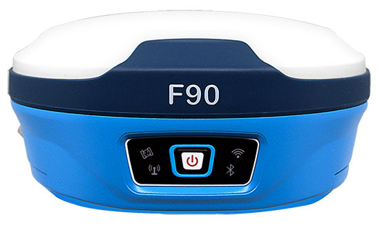
    Geneq Inc. has released the F90, a multi-constellation GNSS receiver with a high level of technology integration. The new product is designed to fulfill surveyors’ demands for performance, flexibility and cost-effectiveness.

    The F90 tracks multiple constellations (GPS, GLONASS, Galileo and Beidou) and can maximize the acquisition and tracking process with all-in-view GNSS satellite frequencies, the company said.

    Providing maximum performance for accuracy and real-time measurements, the F90 also supports real-time kinematic correction services, including the RTX service that can achieve centimeter  accuracy without a base station.

    The F90’s advanced technology ensures a high performance even in harsh environment such as under heavy canopy, Geneq said.

    The F90 has an excellent combination of GNSS, 4G, Bluetooth and Wi-Fi antenna. With highly integrated Bluetooth, Wi-Fi and 4G network modules, and without affecting accuracy and efficiency, the innovative F90 GNSS receiver is light and small. Even with its magnesium-alloy casing, F90 weighs only 1 kilogram and measures 140 x 157 x 76 millimeters.

    With its integrated highly sensitive E-bubble and new tilt survey algorithm, the F90 becomes a calibration-free GNSS receiver, Geneq said. It is immune to magnetic disturbance and free from the limitation of tilt angles so that it can be used to measure inaccessible points.

    Equipped with an internal radio, enabling frequency band change from 410 to 470 MHz, the F90 can be used with different radio communication protocols. Another important feature is its integrated second-generation web user interfae control, which is fully compatible with all devices and all browsers.

    The user will benefit the F90’s two smart hot swappable Lithium batteries (the same battery used with Geneq’s SXPad 1000P data collector), allowing uninterrupted field work for up to 10 hours.

  • Laser Technology offers improved rangefinder with compass

    Laser Technology Inc. (LTI), manufacturer of professional-grade laser rangefinders, has released its improved TruPulse 360 laser, which features LTI’s TruVector 360° Compass Technology.

    The rangefinder has numerous measurement capabilities. According to the company, it can measure slope distance, inclination and azimuth; instantly calculate horizontal and vertical distances; and calculate 3D missing line values.

    The enhanced device offers 33 percent increased distance accuracy, 25 percent better target acquisition and a higher azimuth accuracy of 0.5° root mean squared (RMS).

    “Given its limitless angle and tilt capabilities, the TruPulse 360 is extremely popular for GPS/GNSS offset mapping processes,” said Eric Miller, president of Laser Technology Inc. “The laser’s flexibility enables users to record offsets and attribute data of multiple features from a single location, making data collection quicker, easier and even safer in potentially hazardous situations.”


    The new TruPulse 360 continues LTI’s mission of providing cutting-edge laser measurement solutions in an easy-to-use way, and this model represents an accumulation of more than a decade of work.

    In 2007, the TruPulse 360 integrated LTI’s exclusive TruVector 360° Compass Technology, which was developed from the company’s stand-alone MapStar compass module. The combination of an integrated compass, inclinometer and distance laser gave measurement professionals the best possible azimuth accuracy — and mapping-grade precision — no matter the angle it was shot in, the company said.

    Features

    Photo: LTI
    Photo: LTI

    This latest version of the TruPulse 360, with an even more accurate electronic compass integrated into the laser, continues to deliver added value for the modern measurement professional. Uses include forestry, utilities, construction and GIS mapping.

    In addition to its increased range and azimuth accuracy and Bluetooth-enabled communication, the TruPulse 360 features:

    • Reflectorless technology that enables data capture to any surface type;
    • advanced targeting modes to achieve accurate, repeatable results of the intended target;
    • seven-power superior optics technology that displays all measured and calculated solutions; and
    • Smart technology that recognizes adverse measurement conditions and prompts recalibration.

    “By integrating our great compass technology into this already groundbreaking device, no other laser on the market can match the performance of the TruPulse 360,” Miller said. “And with our continuous commitment to making user-driven enhancements, the TruPulse 360 stands on its own as the best measurement and mapping laser rangefinder out there.”

  • Swift ​​Navigation ​​announces full BeiDou and Galileo support for ​​Piksi Multi

    Swift ​​Navigation ​​announces full BeiDou and Galileo support for ​​Piksi Multi

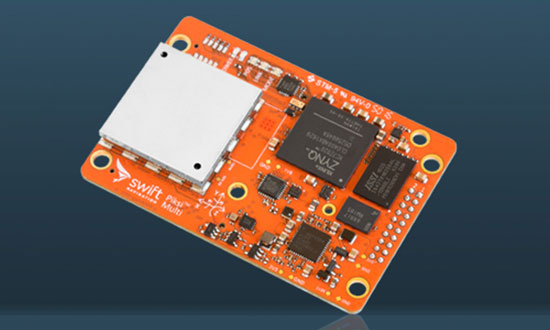
    The Piksi Multi GNSS receiver. (Photo: Swift Navigation)
    The Piksi Multi GNSS receiver. (Photo: Swift Navigation)

    Swift ​​Navigation has upgraded the firmware to ​​its flagship product — the Piksi Multi GNSS ​​receiver. This marks the sixth major release to Piksi Multi since it was launched in February 2017.

    The upgrade is available free of charge to Swift customers. ​​

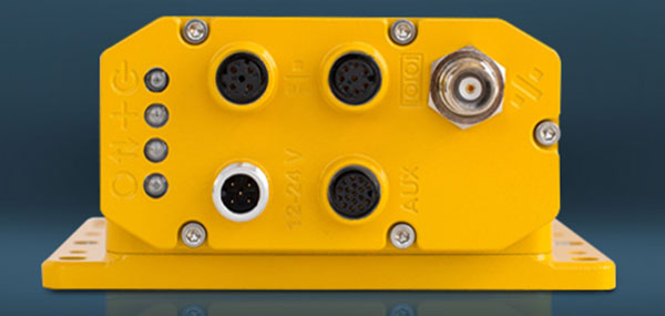
    The firmware release also enhances Duro, the ruggedized version of the Piksi Multi receiver housed in a military-grade, weatherproof enclosure for long-term outdoor deployments.

    Swift ​​Navigation is a ​​San ​​Francisco-based ​​tech ​​firm building centimeter-accurate ​​GNSS ​​technology and a cloud-based corrections service​​ to ​​power ​​a ​​world ​​of ​​autonomous ​​vehicles, the company said. ​​

    The Duro enclosure. (Photo: Swift Navigation)
    The Duro enclosure. (Photo: Swift Navigation)

    Firmware Release 2.0 for Piksi Multi and Duro supports two additional major satellite constellations — the Chinese constellation (BeiDou B1/B2) which, once completed, will contain 37 satellites and the European Union-based constellation (Galileo E1/E5b), which will eventually consist of 30 satellites.

    Adding to the existing GPS, GLONASS and SBAS constellations already supported by Swift’s GNSS receivers means that users will have more access and visibility from satellite systems across the globe.

    Piksi Multi’s performance will further improve over time as the total of 136 satellites planned for these major constellations are fully deployed.

    The addition of BeiDou and Galileo constellations creates more robust positioning performance in a variety of challenging skyview environments and puts Piksi Multi on par with leading industry receivers costing up to ten times a much.

    With this 2.0 release, Piksi Multi is feature-complete, and Swift’s engineering team has delivered on planned product features on the Piksi Multi Product Summary.

    Firmware ​​Version ​​2.0 ​​Enhanced Receiver Performance Highlights

    MSM Messages 4-7. The ​​new ​​firmware ​​adds support for RTCM 3.2 Multi Signal Messages (MSM). Though Swift devices already support RTCM 3.1, the addition of MSM allows for another flavor of differential corrections supported by BeiDou and Galileo, while also supporting both GPS and GLONASS with MSM new messages. MSM also allows for interoperability with other existing third-party GNSS receivers for all modern signals and constellations.

    Fix Improvements. Firmware 2.0 provides Piksi Multi and Duro improvements on fixing in long base lines in poor atmospheric conditions, making the devices more resilient to Ionospheric effects during periods of high Ionospheric activity.

    Higher Baud Rate Support for UART. New baud rates were added including 460800 and 921600.

    Acquisition Improvements. Enhancements made allow Piksi Multi and Duro to power on to a usable signal more quickly and acquire satellites in start-up mode faster, by several seconds.

    “The growing Swift engineering team has been hard at work developing Piksi Multi to its full potential,” said Samir Kapoor, executive vice president of engineering and product at Swift Navigation. “With support for all modern satellite constellations and multiple performance improvements, Piksi Multi offers unmatched affordability, priced at ten times the savings yet on par with other leading GNSS receivers.”

    “Swift’s vision of making GNSS devices that are centimeter-accurate, with fast RTK convergence times and robust positioning performance all at highly-competitive prices has come to fruition,” Kapoor said. “With Piksi Multi feature complete, we look forward to adding to our line of products with additional offerings later this year.” ​

  • Hemisphere GNSS acquires Outback Guidance from AgJunction

    Hemisphere GNSS acquires Outback Guidance from AgJunction

    Hemisphere GNSS Inc. has signed a definitive agreement to purchase all of the assets of the Outback Guidance business from AgJunction Inc., along with a new technology licensing agreement.

    The transaction is expected to close in the third quarter, contingent on normal regulatory approvals.

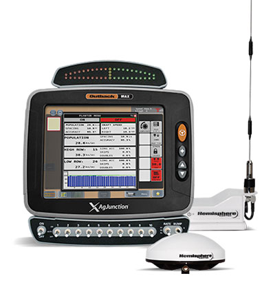
    The Outback MAX terminal with ISOBUS. (Photo: Outback Guidance)

    The acquisition aligns with Hemisphere’s continued push into the global agriculture market, Hemisphere GNSS said. In addition to the included IP licenses for business into the dealer channel, a second license was signed to allow agriculture steering solutions sales into OEM (original equipment manufacturer), VAR (value-added reseller) and all other segments of the agriculture supply chain.

    As a result of these agreements, Hemisphere will assume ownership of the Outback Guidance assets, including channel, infrastructure and trademarks. Additionally, licenses to intellectual property and related technology have been executed.

    Also included are two product development, sales, and support facilities, including personnel located in Hiawatha, Kansas, United States, and Winnipeg, Manitoba, Canada.

    “The decision to acquire the Outback Guidance business will significantly accelerate Hemisphere’s expansion into the global agriculture market and allow stronger integration between Hemisphere’s core competency GNSS and Outback’s highly refined steering solutions,” said Farlin Halsey, president and chief executive officer of Hemisphere GNSS.

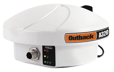
    The Outback A320 smart antenna. (Photo: Outback Guidance)

    “We are very pleased to be bringing on board additional seasoned personnel with strong agriculture domain experience, a strong product line with deeply embedded agricultural technology and a well-accepted, reputable brand in Outback,” Halsey said. “We will also be bringing back together many years of history and legacy between the two organizations.”

    The addition of Outback Guidance represents Hemisphere’s continued effort to make significant investments to expand its presence in the global agricultural market. Hemisphere has seen successful revenues and wide-reaching positive feedback in recent years with its OEM focused agriculture products. Hemisphere seeks to further integrate its high-precision GNSS positioning technology via systems and services offered by the Outback Guidance dealer network, the company said.

    The Outback Guidance channels of communication including customer support, sales, and website will remain as they currently operate. The Outback Guidance dealer network will not see any interruption during this transition period.

  • Rohde & Schwarz expands tester and simulator for V2X standard

    Rohde & Schwarz expands tester and simulator for V2X standard

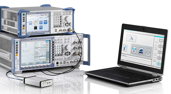
    Rohde & Schwarz has expanded the capabilities of its R&S CMW500 wideband radio communication tester and R&S SMBV100A GNSS simulator to support Global Certification Forum (GCF) protocol conformance tests for C-V2X device certification.

    Utilizing the Qualcomm 9150 C-V2X chipset solution from Qualcomm Technologies Inc., a subsidiary of Qualcomm Incorporated, the R&S CMW500 acting as LTE network simulator now allows automakers to test C-V2X direct communications (PC5) according to GCF Work Item 281.

    3GPP Release 14 specifies the direct communications specifications for C-V2X PC5, which enables vehicle-to-vehicle (V2V), vehicle-to-pedestrian (V2P) and vehicle-to-infrastructure (V2I) safety applications, and does so without a mobile cellular subscription or network assistance and operates in ITS bands 46D (5.8 GHz) and 47 (5.9 GHz).

    The new R&S CMW-KK550 test package includes the 3GPP Protocol Conformance tests from LTE-V2V GCF Work Item 281 and LTE-V2X GCF Work Item 282. As recently announced, the R&S CMW-KU514 C-V2X software package on the R&S CMW500 is used to verify data transmission and reception over the PC5 interface in ideal, faded and congested channel conditions. Together, both packages enable Rohde & Schwarz to support C-V2X device testing through all protocol layers.

    C-V2X device testing is a significant step towards achieving the goal of having fully connected and autonomous vehicles to improve public safety and increase traffic efficiency.

    C-V2X, including direct communications for safety applications, nicely and synergistically complements network-based communications that deliver telematics services and various use cases for connected infotainment and over-the-air software updates.

    “C-V2X PC5 radio technology has quickly advanced to a pre-commercial stage, and Rohde & Schwarz is pleased to be the first test equipment vendor to offer a comprehensive C-V2X test suite,” said Anton Messmer, vice president of mobile radio testers at Rohde & Schwarz. “The automobile industry can now verify functionality and performance of C-V2X devices, as well as start device testing as per 3GPP protocol conformance tests.”

    “This expanded capability complements our support for European eCall and shows our long-standing support for automotive applications,” Messmer said. “Rohde & Schwarz is committed to providing industry-leading test platforms for C-V2X device performance testing and GCF device certification.”

  • Airgain offers 6-in-1 and 5-in-1 antennas with GNSS, LTE, Wi-Fi

    Airgain offers 6-in-1 and 5-in-1 antennas with GNSS, LTE, Wi-Fi

    Photo: Airgain
    Photo: Airgain

    Airgain Inc. has released its Multimax FV 6-in-1 and 5-in-1 antennas.

    The compact Multimax FV family is available in a range of configurations, supporting multi-constellation GNSS. The antennas also support up to dual MIMO LTE (including Band 14 for the FirstNet public safety network), 3×3 MIMO Wi-Fi or 2×2 MIMO Wi-Fi.

    Airgain is a provider of advanced antenna technologies used to enable high-performance wireless networking across a broad range of devices and markets, including connected home, enterprise, automotive and internet of things.

    With a small footprint and a strong, bolt-mount aluminum base, the Multimax FV family provides protection against natural hazards threatening vehicles, including vibration, ice, salt, car washes and tree sweeps.

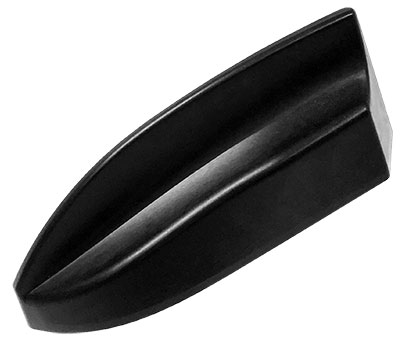
    In addition, the elegant shark-fin design allows fleet owners to add style to their vehicles without compromising performance.

    The new products include high-gain antennas that deliver a larger cellular footprint alongside high rejection GNSS technology with coverage for multiple satellite systems including GPS, GLONASS, Galileo and BeiDou.

    “Not only does reliable connectivity matter to fleet owners, but also aesthetics and the antenna form factor,” said Reed Pangborn, Airgain’s vice president of Channel Sales for North America. “Our new Multimax FV family is uniquely designed to deliver in each of these key areas. Owners can rely on our commitment to providing class-leading performance across cellular, Wi-Fi and GNSS as well as our industry-best reliability, but all built into a new, sleeker design that complements today’s fleet vehicles.”

    The Multimax FV family of antennas can be ordered in either black or white and are available now.

  • Volcanic GIS: Mapping and imaging the Kilauea eruption

    A number of geospatial companies played a key role in the government’s response to the Kilauea Volcano eruption. The volcano on the Big Island of Hawaii began erupting May 3, and while quiet for more than a week, it could resume erupting at any time.

    Mapping the flow. As a resident of Hawaii, Brennan O’Neill, Hawaiian branch manager of Frontier Precision, was in a unique position to offer support. Frontier Precision provided free access to technology and expertise to assist in mapping the lava flow.

    “I had to help out,” O’Neill said. “It was tearing at my soul. For a geologist, it’s even more powerful than that. The lava flow is like a living mass that has a mind of its own, creeping, glowing — an upside-down conveyor belt surging forward and burning everything in its path.”

    Through Frontier Precision, O’Neill offered high-tech mapping equipment, his own expertise, and the help of Nathan Stephenson, an applied geospatial engineer working in the company’s Denver office.

    “We used a combination of Trimble R10s and Trimble R8s to gather accurate data points on the ground,” Stephenson said.

    This thermal map shows the fissure system and lava flows as of 6 a.m. on Saturday, Aug. 11. The thermal map was constructed by stitching many overlapping oblique thermal images collected by a handheld thermal camera during a helicopter overflight of the flow field. The base is a copyrighted color satellite image (used with permission) provided by Digital Globe. (Map: USGS)
    This thermal map shows the fissure system and lava flows as of 6 a.m. on Saturday, Aug. 11. The thermal map was constructed by stitching many overlapping oblique thermal images collected by a handheld thermal camera during a helicopter overflight of the flow field. The base is a copyrighted color satellite image (used with permission) provided by Digital Globe. (Map: USGS)

    The mapping team flew UAS drones over the flow to gather visual imagery data, matched it to the ground reference points, stitched the photos together and draped it over county maps. The process was repeated as often as needed — daily, and sometimes even hourly — to show the speed and direction of the flow.

    Stephenson isn’t new to mapping lava flows. As a graduate student at the University of Hawaii – Hilo, he worked on collecting data on the Pahoa eruption in 2014, and he’s seen advances in technology in just a few years.

    “One thing we have now that we didn’t have in 2014 was a thermal radiometric camera that helps us map more accurately at night and enables us to capture large heat signatures.”

    The collected data helps Hawaii Civil Defense and other agencies keep the public informed and safe, and in the long term it also contributes to the store of scientific knowledge about eruptions and lava flow behavior.

    Lidar image of the Hawaii dataset showing the Kilauea Calderand the Halena'uma'u Crater and within it. (Image: Quantum Spatial)
    Lidar image of the Hawaii dataset showing the Kilauea Calderand the Halena’uma’u Crater and within it. (Image: Quantum Spatial)

    Airborne lidar insights. Another technology that aids in volcano response is lidar. High-resolution lidar surveys help first responders, scientists and government agencies monitor Kilauea conditions and predict future lava flows.

    Independent geospatial data firm Quantum Spatial Inc. (QSI) has conducted high-resolution lidar surveys of areas surrounding the Kilauea volcano eruption in Hawaii.

    The emergency response effort was part of the U.S. Geological Survey’s (USGS) Rapid Response Imagery Products (RRIP) in support of the Kilauea’s 2018 East Rift Zone – Remote Sensing Acquisition Requirement.

    The USGS Hawaiian Volcano Observatory (HVO), along with emergency responders, government agencies and academics, will use the data to better understand the conditions and characteristics of the volcano, and help planners model potential lava flows, which may better predict and respond to future flows and enhance safety of residents.

    The QSI team, which included GEO1 and Windward Aviation, deployed within days to acquire high-resolution lidar at point densities averaging from 40 to 80 ppsm, with up to 150 ppsm in select areas and 100-mp digital imagery using a Riegl dual VUX-1 LR sensor pod equipped with ABGPS/IMU mounted on a Hughes 500D helicopter.

    The project required 11 missions over the course of six days, operating at times as low as 500 feet above the ground and above active flows and nearby erupting calderas. With a need for a quick turn around, QSI deployed an analyst with the flight crew to post process each mission within hours of collection.

    The data was uploaded to the Geospatial Repository and Data Management System (GRiD) interface, developed by the U.S. Army Corps of Engineers (USACE), where additional data products have been developed and provided to the response team that includes FEMA, Hawaii’s Emergency Operations Center (EOC) and the Hawaii County Civil Defense.

    After data collection, QSI measured topographic shifts during the processing by comparing new data with a 2011 lidar collection from the same area. Survey specialists and USGS experts confirmed within hours of processing QSI’s lidar data that areas within the site had shifted up to 1.5 meters east, 2 meters to the north and 1 meter in elevation.

    USGS scientists will continue to examine the new topographic data to better understand the nature of these shifts, and integrate it into lava flow models for more accurate predictive modeling.

    The eruption in action. Using small unmanned aerial systems (sUAS) together with air-quality sensors, advanced imaging tools and Esri’s spatial analytics and mapping, a team from the Center for Robot-Assisted Search and Rescue (CRASAR) provided real-time aerial views of the eruption.

    The five volunteers armed with drones, advanced sensor systems and GIS technologies joined the response effort May 14-19 at Kilauea Volcano Lower East Rift Zone to assist in tracking and predicting the ongoing volcanic eruption. The team supplemented the University of Hawaii Hilo’s (UHH) sUAS capabilities, allowing UHH sUAS operators to focus on geographical and volcanology.

    The CRASAR team identified a new fissure not visible from the ground, projected the lava flow rate during the night when manned helicopters were not allowed to fly, and provided ongoing data collection from new thermal sensors technology.

    After the project, CRASAR published lessons learned on its blog:

    • Night flights of UAVs are very effective.
    • Rotorcraft UAVs can effectively sample gas.
    • Rotorcraft UAVs with thermal sensors are very effective.
    • Rotorcraft UAVs provide a quick look at lava flow rates.
    • Plumes will interfere with photogrammetric mapping.
    • Hanger 360 (software) rapidly produced panoramas.

    During the six-day Leilani deployment, the CRASAR team flew 44 sUAS flights, including 16 at night, using DJI 200, 210, Inspire, and Mavic Pro drones. Esri’s Drone2Map for ArcGIS together with Hangar’s Enterprise Platform for 360-degree imaging enabled rapid 360-imaging for situational awareness.

    DJI’s new XT2 thermal sensor provided unprecedented drone-based air-quality monitoring. Video and data were shared with local first responders using FirstNet, the first high-speed, nationwide wireless broadband network dedicated to public safety.

    The CRASAR response marks the first known use of sUAS for emergency response to a volcanic eruption and first known use of sUAS for sampling air quality.

    The GIS mapping and imaging technologies responders used on the scene at Kilauea Volcano Lower East Rift Zone are available here.