Helix Technologies Ltd., a U.K.-based developer of high-performance, ceramic-based helix antennas, has secured funding that will enable continued development of antennas for a wide range of applications including autonomous vehicles, drones, internet of things and machine-to-machine communications.
Photo: HelixAntenia
The company closed its Phase B funding round with GBP 650,000 of financing provided by private investors.
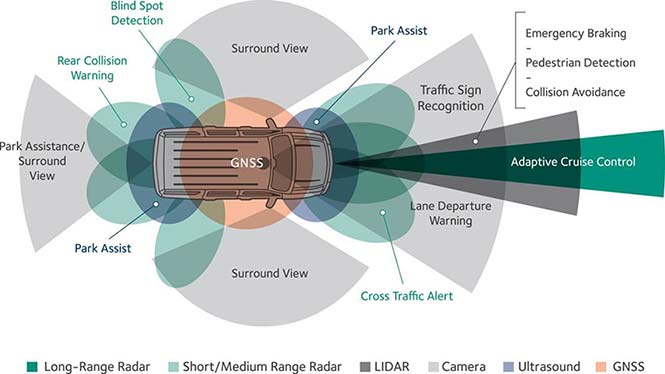
The company said that the driverless car segment, both GNSS and vehicle-to-everything (V2X) dedicated short-range communications (DSRC) applications, represents the most immediate and compelling need and business opportunity for its helix antenna technology.
Helix Technologies said its dielectric-loaded helix antennas will provide significant performance advantages over incumbent antenna technologies for next-generation GNSS and V2X applications.
The use of a dielectric ceramic core gives its antennas unique properties including unsurpassed gain/efficiency per unit of volume and more effective and predictable behaviour in a wide range of challenging user scenarios.
“We are grateful for the support of our investors which allows us to develop innovative solutions for this exciting growth market,” said John Yates, managing director of Helix Technologies. “The first self-driving cars are widely forecast to be on the market between 2019 and 2021. Any navigation and communications equipment used onboard will have to fulfil the highest-possible standards on safety, integrity and accuracy.”
The company expects to have prototypes of its V2X DSRC antenna available by the second quarter of 2018 and its NEXTGEN GNSS antenna by the third quarter of 2018.
According to the company, the use of the ceramic core enables the fabrication of antennas that are physically smaller than conventional antennas, behave much more effectively and predictably in a wide range of challenging user scenarios and have many compelling technical advantages which include:
Maintaining radiation efficiency near absorbing objects (such as the human body)
Improving the accuracy of GNSS systems in multipath environments (such as in cities)
Operation in sub-optimal orientations towards the sky
Are able to be placed into very tightly integrated systems
Operation in slim devices without a ground plane
Unsurpassed gain/efficiency per unit of volume
Simple and robust design and construction for durability and reliability
u‑blox is offering the automotive-grade MAX‑M8Q‑01A GNSS module, which measures 9.7 x 10.1 x 2.5 millimeters and has an operating temperature range from –40 degrees Celsius to 105 degrees Celsius.
The MAX‑M8Q is the company’s third automotive-grade GNSS module to date, alongside the NEO‑M8Q‑01A and NEO‑M8L‑03A modules.
MAX‑M8Q‑01A is designed to meet the stringent requirements of the automotive market, providing superior positioning accuracy even in challenging environments such as urban canyons. Its extended temperature range ensures reliable performance even in harsh environments, e.g. when mounted in a car‑roof antenna.
Produced in adherence to the u‑blox 0 ppm program, which aims to bring down product failures rates to zero and consistently achieve high production quality, the module is delivered with the automotive industry’s standard PPAP documentation to ensure compliance with customer requirements.
The module offers product developers a reduction of design and qualification time and effort, shortening time‑to‑market and considerably reducing risks for new product development.
“We developed this automotive grade GNSS module in the small MAX form factor in response to customer requests for a GNSS receiver that operates reliably in an extended temperature range,” said Franck Berny, senior principal, automotive market development, u-blox. “We are confident that the module’s high quality, robust and secure performance, and small form factor will appeal to the automotive industry at large.”
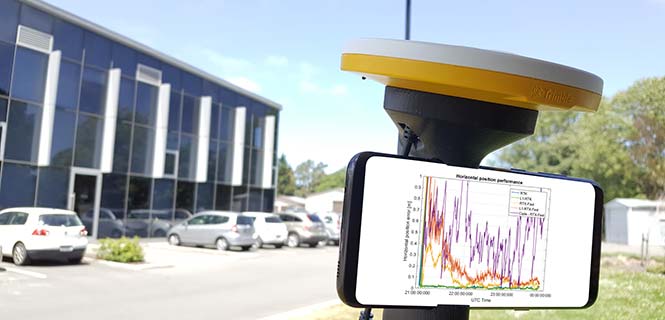
For those who want high accuracy, but don’t need it full time, high-productivity dedicated professional solutions may not be cost-justified. In these cases, a “positioning as a service” subscription could offer a viable use model.
Achieving precision positioning with just a standard mobile device, a correction stream using the mobile device’s data connection and a high-accuracy positioning application produces a very low barrier to achieving high accuracy.
ByStuart Riley, Herbert Landau, Victor Gomez, Nataliya Mishukova, Will Lentz and Adam Clare, Trimble Inc.
We expect that for professional applications that need precision positions, a dedicated system that employs a custom GNSS chipset and purpose-built applications will continue to be the right solution. However, it becomes clear that the ubiquity of consumer mobile devices, with increasing computing power, ruggedness and an expanding feature set, presents fertile ground for new development of improved positioning systems that don’t have strict professional requirements.
A range of new use models and applications will be enabled by consumer mobile phones with technology that improves positioning performance. The goal of the work presented here is to assess what level of performance can be achieved by using proprietary PVT (position, velocity, time) engines utilizing GNSS measurements from the Android GNSS measurement application programming interface (API).
We first review GNSS measurement and positioning performance from a subset of the current Android phones/tablets currently on the market. Then we show the position performance achievable using precision engine with measurements from a dual-frequency GNSS chipset targeted for the cellular handset market. This class of device is expected to be integrated into consumer cellular devices on the market within the next 1 to 2 years.
Performance of Current Phones
We tested various devices including the Nexus 9 (which provides phase data) and various other Android devices that implement the new API. Most devices tested do not support phase data; of the few devices tested that do provide phase data, all except the Nexus 9 implement GNSS power duty cycling. This is a mode where the GNSS chipset is only active for a fraction of each second to reduce power consumption. This results in cycle slips each epoch, which makes carrier-phase processing for real-time kinematic (RTK) unusable.
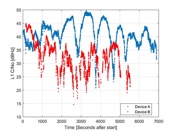
During the testing a wide range of performance across devices was observed. Figure 1 shows the C/NO for a high-elevation GPS satellite collected at the same time from two different Android models that implement the GNSS measurement API. The units were located in a clear environment less than a meter apart. Deep fades are present, most likely caused by deconstructive multipath.
Figure 1. Comparison of the C/NO from two different Android devices.
However, the devices show significantly different tracking performance: device B reports over 10 dB lower C/NO for much of the test and eventually stops reporting measurements. During our analysis, around six different Android devices have been tested; it isn’t clear whether the devices tested are typical over a broader population of device types.
Before attempting to position with observables from Android devices the measurement quality was analyzed. As only a subset of current devices that support the API provide phase information we wanted to evaluate both a phase-based RTK engine and a pseudorange/Doppler based code engine to determine what is possible from each class of device.
One of the devices tested was a Samsung S7 device. It provides pseudorange, Doppler and phase via the GNSS measurement API. However, the phone implements power duty cycling so after a short period of operation the duty cycling mode was enabled which resulted in a cycle slip on the phase every epoch.
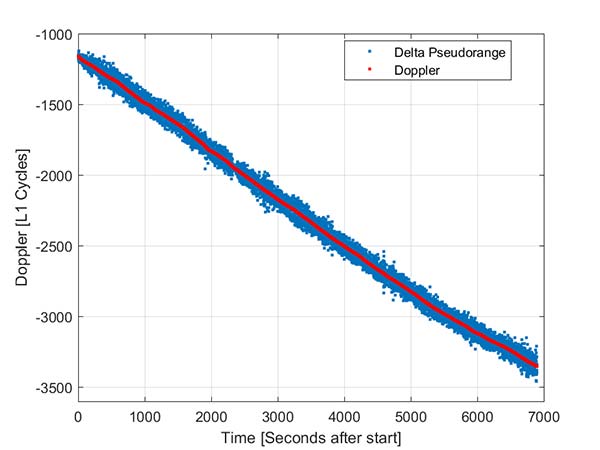
To derive an improved position from this class of device pseudorange and Doppler can be fed into a code-phase positioning engine. Fortunately, the Doppler provided by the device is of reasonable quality as can be seen from Figure 2.
Figure 2. Android GNSS observables: Doppler versus time-differenced pseudorange.
In this simple analysis measurements from a single high elevation satellite were analyzed. The Doppler is plotted along with the differenced pseudorange converted into L1 cycles. It can be seen that as expected the Doppler has much lower noise and so can be used in a pseudorange smoother.
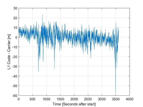
A simple way to view the pseudorange noise is to subtract the carrier phase from the pseudorange. If there are no cycle slips this should show ionospheric divergence with the noise dominated by the pseudorange noise. The absolute level is arbitrary as it includes integer carrier cycles. Figure 3 shows an example from an Android device.
The data was captured on a building roof in an open environment. There’s a slight downward trend due to the ionospheric divergence between code and carrier, but the metric is dominated by the pseudorange noise. For this example from a high elevation GPS satellite the standard deviation is 6.5 meters. For comparison, a precision receiver connected to a precision GNSS antenna providing unsmoothed pseudorange in this environment would have a standard deviation of a few decimeters.
Another way to assess the measurement performance is to form double difference residuals. Data was logged from pairs of identical devices mounted with a common orientation. An RTK system was used to measure the same point on each device. The camera lens location above the screen was used as the reference point.
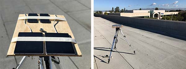
An accurate vector between the two references points was computed and used as truth in a double-difference residual analysis. Even though we do not know the precise location of the phase center of the antenna, because the difference was performed between two devices that are the same model and have the same orientation the error in the phase center location is common and will cancel. Various pairs of devices were tested by being mounted on a wooden board on a tripod at approximately waist height. The test configuration is shown in Figure 4.
Figure 4. Android device test configuration.
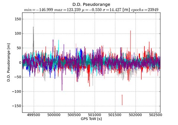
Figure 5 provides the double difference GPS L1 C/A pseudorange residuals between two Android devices. We see errors beyond 100 meters and a standard deviation across all data of 14.4 meters. A precision system (RTK or RTX/PPP) would use a standard survey quality base or network of bases and not an Android device for the correction data.
Figure 5. Short baseline double-difference pseudorange, Android devices.
Consequently in a typical operating mode where a precision data stream provides corrections, the contribution in a double difference from the pseudorange on the Android devices would be roughly half the Android-to-Android residual seen in this test or approximately 7.2 meters for this example.
For comparison, the same metric was generated between two precision GNSS units connected to antennas on the same roof. While the data was not from the same time period, we observe very consistent performance over time.
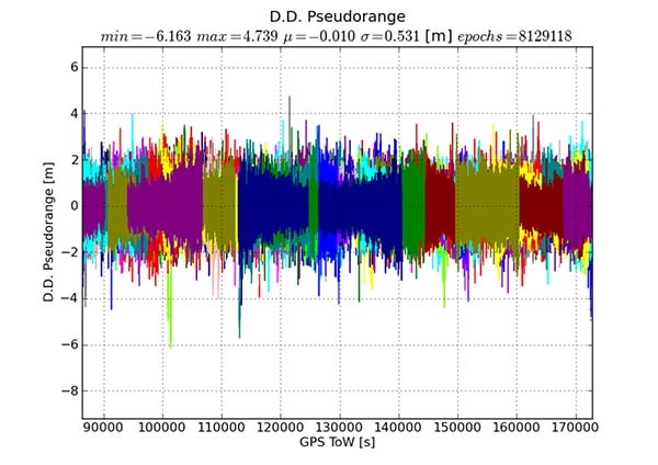
Figure 6 shows the same pseudorange double difference across a short baseline over 24 hours. When comparing Figures 5 and 6, note the difference in the scale on the pseudorange residual axis. The standard deviation from a pair of precision devices is 53 centimeters (cm) or 27 times lower noise than an example pair of Android devices.
Figure 6. Short baseline double-difference pseudorange, precision devices.
All phones that provide GNSS measurements via the Android API publish the phase data in the accumulated delta range field. An accumulated delta range is not necessarily a full phase measurement; it can have an arbitrary starting phase.
For example, in a precision GNSS receiver, if the receiver locks to a satellite and some time later locks a second channel to the same satellite, the phase measurement from the two channels may have a different integer cycle component, but the subcycle component would be the same except for millimetric tracking noise.
If the two channels are providing accumulated delta range the initial phase offset may differ by up to one cycle. From the population of Android devices that publish phase that we have tested we have not observed any devices that deliver true full phase.
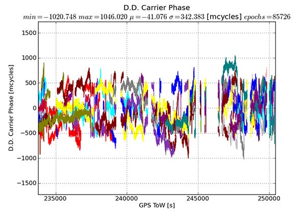
They all deliver an accumulated delta range with an arbitrary phase offset. This limits a phase engine to float processing and ambiguity fixing is not possible. The Android phase data collected from the previously described experiment was processed to provide the double difference carrier residuals. This is shown in Figure 7.
Figure 7. Short baseline double-difference phase residuals, Android devices.
The y-axis is in millicycles (1,000 millicycles = 1 cycle or approximately 19 cm for L1 GPS). Jumps are seen as the reference satellite changes or when the measurements have cycle slips. In this case the standard deviation is 342 millicycles. A double difference residual on a precision receiver in a similar environment with a high-quality antenna on a short baseline is an order of magnitude lower than this.
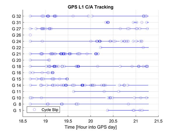
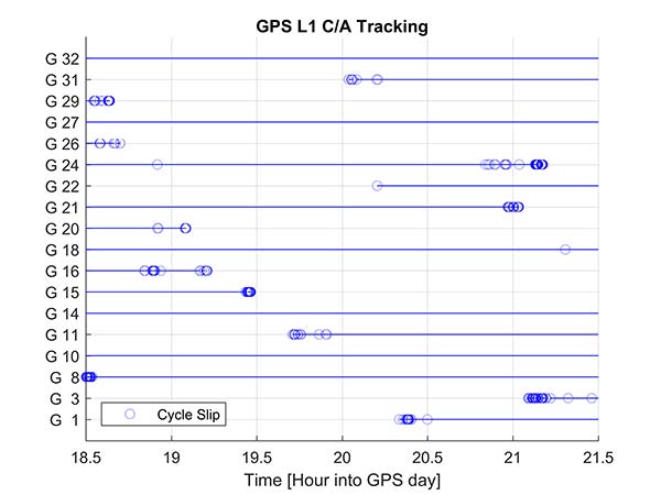
Another useful metric to review are the number of reported cycle slips. Figures 8 and 9 show a comparison of the cycle slips reported on GPS L1 C/A from an Android device compared to data logged on a precision receiver over the same time span. The receiver tends to only cycle slip at low elevation; the device had a zero-degree mask. The Android GNSS device cycle slips at higher elevations, probably a result of deep multipath fades due to the poorer antenna.
In an ION GNSS+ 2017 paper, we showed the achievable position performance using an RTK engine that had been previously customized to operate with measurements from consumer GNSS chipsets. It operated in a float mode due to the sub-cycle issue found in phase data from Android devices.
We also demonstrated the performance from a precision code-based PVT engine that had changes to the a priori measurement error estimate, a modified pseudorange/Doppler Hatch filter and used SBAS data to correct the position. As very few current Android devices deliver phase information the two engines were used to analyze what is possible today with the pseudorange and may be available in the future as phase is more universally available.
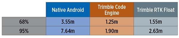
Data was processed from a Nexus 9 tablet, the only known Android device that has GNSS power duty cycling disabled. The unit was unmodified and so the Android tablet’s integrated GNSS antennas were used. The 2D performance is given in Table 1.
Table 1. 2D performance from Nexus 9 Android tablet.
Only GPS L1 and GLONASS L1 measurements were used and the RTK float solution delivered similar performance to the pseudorange solution. This is due to a combination of issues, very high pseudorange noise, and a significant number of cycle slips (see Figures 5 and 8). Only single frequency data was available, and while the engines used had been tuned for consumer data, they were not specifically designed for this class of data.
Next-Generation Phones
Within the next couple of years improved chipsets are expected to be available to consumers that will result in improvements in achievable positioning performance. In May 2017, Broadcom provided us with a development kit for its next generation L1/L5 multi-system BCM47755 GNSS chipset. This allowed us to assess what may be possible when improved GNSS chipsets are integrated in the next generation of cellular devices.
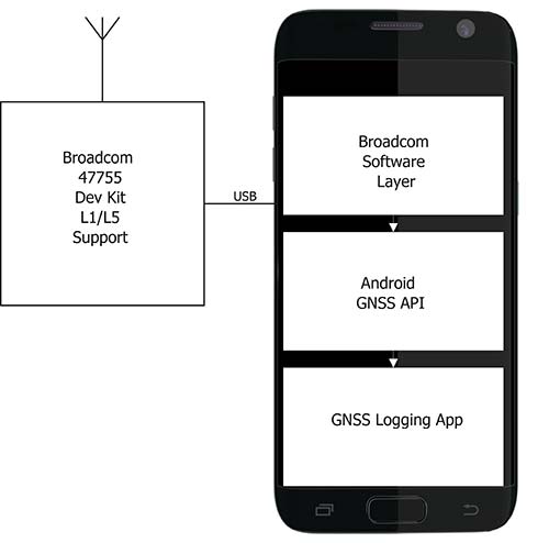
Figure 10. Broadcom BCM47755 development system.
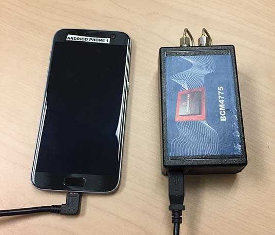
The development environment included the GNSS chipset with an external antenna port so both a cell-phone equivalent antenna and a precision antenna could be compared. This allowed us to evaluate the impact of the antenna performance on the GNSS observables and positioning results. The Broadcom GNSS development system communicates via USB to a Samsung S7 phone and publishes data via the Android GNSS measurement API so the equivalent data flow of an integrated cellular device is maintained (see Figure 10).
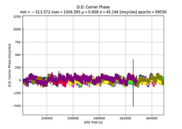
In our ION paper, we showed the typical phase double-difference residuals observed from current Android devices. The Broadcom BCM47755 originally provided similar performance, although it also supports GPS L5 and Galileo E5A. In November 2017, Broadcom provided a firmware update that resolved the sub-cycle phase issues. With the updated Broadcom software, the double difference carrier residuals for GPS L1 on a zero baseline when differencing a precision receiver to a Broadcom BCM47755 are shown in Figure 11.
Figure 11. Precision GNSS to Broadcom BCM47755 zero baseline double difference carrier-phase residuals.
The standard deviation is 45 millicycles which is approximately 8.6 millimeters (mm). This is substantially better than earlier implementations of the Android GNSS interface (see Figure 7) and sufficient to perform RTK ambiguity resolution.
The rest of the results in this article were obtained with the improved firmware along with a new precision position engine. This engine was designed from inception to support GNSS measurements with differing quality and so can more optimally process the Android GNSS data. The effect of the improvements to the Broadcom firmware and the change in the processing engine can be seen if the results in our ION paper are compared to the data in this section.
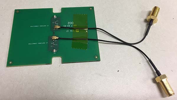
To attempt to model what may be possible with a phone based on a next-generation chipset, a cell-phone equivalent antenna provided by Broadcom was used in some of the tests with the development system, as shown in Figure 12. This device has separate feeds for L1 and L5.
Figure 12. Cellular equivalent antenna.
Datasets were collected with the multi-frequency GNSS BCM47755 device. The data was captured in the Android GNSS measurement API format and converted to proprietary format files for further processing. All data was collected in Sunnyvale, California.
Measurements from GPS L1/L5, Galileo L1/E5A, GLONASS L1 and BeiDou B1 were logged and analyzed. The Precise Positioning Engine (PPE) allows performing carrier-phase RTX and RTK and a pseudorange-based solution using the RTX corrections. Tests were performed by using a precision antenna and a cell-phone equivalent GNSS antenna.
With Precision GNSS Antenna
These datasets were collected on a zero baseline with a precision receiver to allow a direct comparison of results with a professional receiver. The first test was on Nov. 22, 2017, where the Broadcom GNSS chip and the receiver were connected to the same professional antenna.
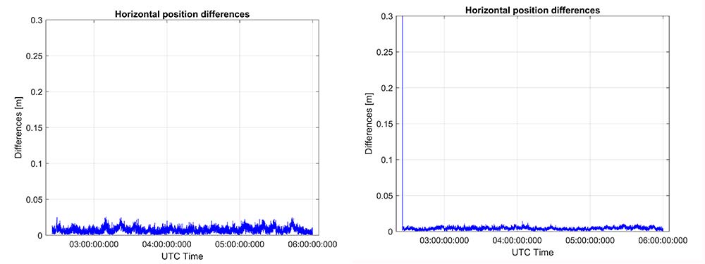
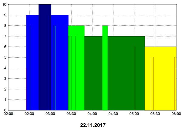
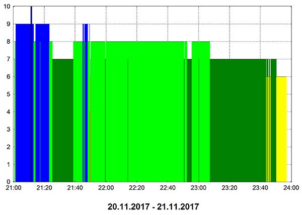
As seen in Figure 13, both GNSS receivers provide centimeter-level accuracies after some convergence time. With the current satellite constellations, only a third of the GPS satellites have L5 and only about half of the E5-capable Galileo constellation is in space. During this 3.5-hour test, the number of dual-frequency measurements processed by the engine that used the Broadcom chipset — data that does not support L2 — ranged between 6 and 10 satellites (Figure 14).
Figure 13. RTK performance for a 3.5-hour dataset sampled on Nov 22. Broadcom chip at left and precision chip at right. A short baseline was used — precision antenna.Figure 14. Number of GPS L1/L5 plus Galileo E1/E5A dual-frequency measurements used by the position solution based on the Broadcom chipset — precision antenna.
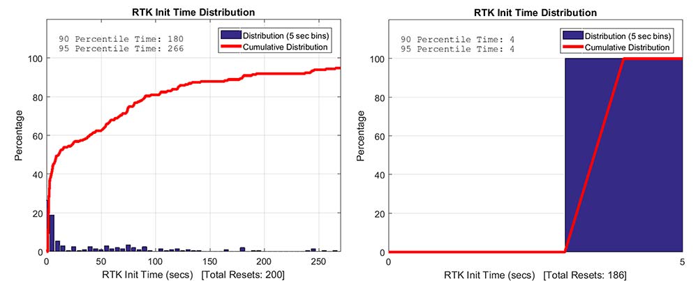
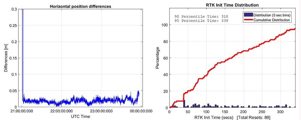
Convergence times were measured with post-processing tools by splitting the datasets into individual time spans. Figure 15 shows that the consumer GNSS chipset is able to get fixed ambiguity solutions but it takes considerably more time (266 seconds versus 4 seconds) for the 95% of initializations. However, the system is fixing ambiguities and provides centimeter level positioning.
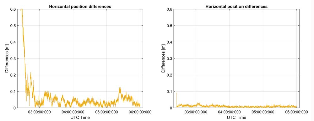
The same datasets were also processed with RTX-Fast in California. Thus the base station data was replaced by a global/regional correction stream received from an internet-based data source (Figure 16).
Figure 15. RTK initialization performance, dataset sampled on Nov 22. Broadcom chip at left and precision receiver at right — precision antenna.Figure 16. RTX performance for a 3.5 hour dataset sampled on Nov. 22 (Broadcom chip at left and Trimble chip at right) — precision antenna.
Horizontal accuracy for Broadcom reach 10 cm while the precision receiver reaches better than 3 cm. The degradation is in part due to the difference in quality of the carrier phase and the different number of dual frequency satellites processed. Precision devices provide measurements on E1/L1, L2 and L5/E5 providing at least dual frequency data from GPS, GLONASS, Galileo, BeiDou and QZSS.
The Broadcom chipset tested provided dual frequency GPS and Galileo along with single-frequency GLONASS and BeiDou; however, due to limited BeiDou constellation visible in California, data from this constellation was not used.
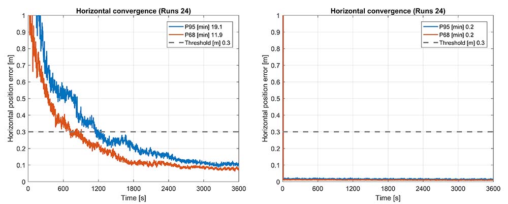
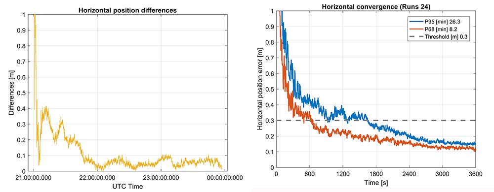
Convergence was also analyzed and is shown in Figure 17. From the data, we generated 24 convergence runs by taking one hour, progressively shifting the start time by 5 minutes and running the data with different start times through the PPE engine. This produced 24 runs, which were translated into 68% and 95% convergence statics shown.
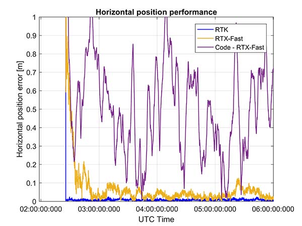
Figure 17. RTX convergence performance for a 3.5-hour dataset sampled on Nov. 22. Broadcom chip at left and precision chip at right — precision antenna.Figure 18. Code RTX performance for 3.5-hour dataset sampled Nov. 22 and corresponding RTK and RTX phase solutions — precision antenna.
The RTX-Fast solution for Broadcom reaches 30 cm horizontal error in 68% of the cases in approximately 12 minutes. The RTX-Fast convergence using precision GNSS data is near instantaneous as can be seen in the right of Figures 16 and 17, reaching centimeter accuracy.
The code position solution using the RTX correction stream provides sub-meter positioning (Figure 18).
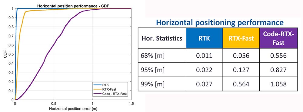
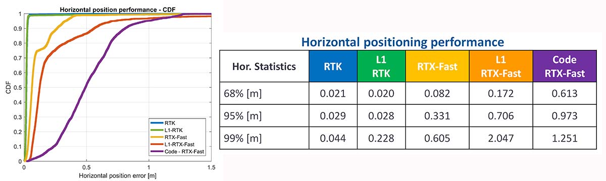
As a summary, the cumulative distribution function plots (Figure 19) show the performance differences for this static environment, on Nov. 22.
Figure 19. CDF plots for the different PPE position solutions — precision antenna.
Cell-Phone GNSS Antenna Results
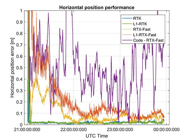
Similar tests were performed using an external cell-phone GNSS antenna, which is close to the antenna used in a typical smartphone. RTK performance shows centimeter-level accuracies and reasonable convergence times, which are slightly worse than the results with the professional antenna (Figures 20–24).
Figure 20. RTK positioning and initialization performance for the Broadcom chip and the cell antenna sampled on Nov 20 — cell-phone GNSS antenna.Figure 21. RTX-Fast positioning and convergence performance for the Broadcom chip and the cell antenna sampled on Nov. 20 — cell-phone GNSS antenna.
In general as expected we achieve worse performance when connected to the GNSS cell-phone antenna for all the different positioning modes. For the cell antenna we also generated single-frequency RTK and single-frequency RTX-Fast position solutions and compare it with a code positioning solution.
Positioning Engine in Android
Figure 22. Number of GPS L1/L5 plus Galileo E1/E5A dual-frequency measurements used by the position solution based on the Broadcom chipset — cell-phone GNSS antenna.
The results presented in this article captured GNSS data using the Android API and then post-processed the data using PC versions of the position engines. A significant amount of data has been captured and analyzed using this method.
For the purpose of real-world demonstration the PPE has been implemented in an Android app to be used in cell phone devices. This PPE is able to provide RTK, RTX and code based positioning technology in one single PPE library.
The app has been tested running on a Samsung S7 connected to Broadcom’s new chipset development kit as well as a Nexus 9 tablet that uses an older generation GNSS chipset.
Figure 23. Code RTX performance, the dataset sampled Nov. 20 and corresponding RTK and RTX phase solutions — cell-phone GNSS antenna.
Future work will refine this solution as well as evaluate how well the system works when mobile. The data collected in this article operated in an environment with a clear view of the sky. We plan to characterize what happens when the platform moves with both pedestrian and automotive dynamics, as well as the effects of body masking and challenges with changes to the GNSS antenna reception pattern when the phone is held.
Summary
While this article has highlighted that sub-meter and centimeter accuracy have been achieved in a laboratory environment, there are many challenges to be addressed before centimeter accuracy in a phone can be achieved with performance suitable for users in real-world environments.
Figure 24. CDF plots for the different PPE position solutions for cell antenna dataset.
The challenges include very high multipath, significant differences in the tracking performance between different devices, and high rates of cycle slips. As very few Android-based devices provide continuous phase, a pseudorange/Doppler-based engine has been modified to accept Android data.
Based on the testing with existing devices it is possible to achieve position solutions of 1–2-meter accuracy in ideal static scenarios. This is a significant improvement in accuracy for Android based devices.
Figure 25. PPE engine on a Samsung S7 with a Broadcom BCM4775 evaluation kit.
However, as performance differences were observed between different mobile devices significantly more data needs to be collected over a larger set of devices to review the repeatability of these preliminary results from existing Android devices.
The Broadcom BCM47755 development kit for a dual-frequency GNSS chipset intended for future phones has allowed us to review the potential position performance that may be achievable in a handset in a few years.
By connecting this next-generation GNSS chipset to a GNSS antenna typical of a cellular device and comparing the performance from a precision GNSS antenna, we’ve shown for the first time that it is possible to produce precision positions from a static cellular class GNSS device in ideal conditions at the centimeter level with both an RTK solution and a PPP solution.
However, due to the significantly higher measurement noise and high multipath from the cellular device’s GNSS antenna, the convergence times to reach centimeter level remain a challenge; although using dual-frequency phase data from a cellular GNSS chipset with a PPE and RTX service, the position is very rapidly sub-meter.
Future work will focus on analyzing how the performance changes when operating in the normal user environment. The effects on the measurements of user motion, body masking and de-tuning of the antenna when the device is held need to be quantified. The Nexus 9 tablet used in this article does not have integrated cellular. The Broadcom development kit connects to the phone via a cable and is also not integrated into the handset.
We will be evaluating what may happen with a more integrated unit to make sure emissions from devices with integrated cellular very close to the GNSS antenna do not result in further degradation.
As the position performance is very sensitive to the quality of the antenna from both multipath and cycle slips due to low C/NO and deep fades, we’ll also evaluate how well the performance of the PCB-based GNSS antenna, which is part of the BCM47755 evaluation kit, matches current handsets.
Acknowledgment
This article further develops work first shown in an ION GNSS+ 2017 paper, “On the Path to Precision — Observations with Android GNSS Observables.”
Manufacturers
Trimble CenterPoint RTX is the satellite orbit and clock corrections service used here, enabling a PPP-like positioning with ambiguity fixing, providing better than 4 cm with typically less than 10 minutes’ convergence.
RTX-Fast functionality in Europe and parts of California uses regional atmospheric models to provide better than 4-cm horizontal in typically less than one minute. When precision and professional receivers and RTK engines are mentioned in this article, they are Trimble devices, the BD940 receiver in some cases.
A Trimble Zephyr 3 antenna was used in many tests shown here.
The global market for precision agriculture solutions is forecast to grow from €2.2 billion ($2.6 billion) in 2016 at a compound annual growth rate (CAGR) of 13.6 percent to reach about €4.2 billion ($5 billion) in 2021, according to a research report from the market analyst firm Berg Insight.
A set of technologies are applied in precision farming practices that are aimed at managing variations in the field to maximize yield, raise productivity and reduce consumption of agricultural inputs. While solutions such as auto-guidance and machine monitoring and control via onboard displays are mainstream technologies in the agricultural industry, telematics and variable rate technology (VRT) are still in the early stages of adoption.
Interoperability between hardware and software solutions remains a challenge, although standardization initiatives led by organizations such as Agricultural Industry Electronics Foundation and AgGateway are making progress.
Most major agricultural equipment manufacturers have initiatives related to precision agriculture, although strategies vary markedly. Leading vendors include agricultural equipment manufacturer Deere & Company, followed by the U.S.-based precision technology vendors Trimble, Topcon Positioning Systems, Raven Industries and Ag Leader Technology. Hexagon further holds a strong position in the positioning segment through its subsidiary NovAtel.
A group of companies have emerged as leaders in the nascent market for in-field sensor systems. These include Davis Instruments, Pessl Instruments with its METOS brand, Semios, Hortau, AquaSpy and CropX.
Providing high-speed internet access to businesses and residences is a highly active and expanding field. It closely involves geographic information systems (GIS) to efficiently achieve fiber to the home (FTTH) or fiber to the premises (FTTP), the installation and use of optical fiber from a central point directly to individual buildings such as residences, apartment buildings and businesses for high-speed internet access.
A free webinar on Jan. 18 will cover — among several other related topics — the integration of high-accuracy aerial imagery into this process. David K. Nelson, GISP, a GIS manager in telecommunications for Black & Veatch, will make the presentation. It will be complemented by a talk on how to “Plan Virtually, Manage Efficiently with High-Definition (HD) Aerial Maps” by imagery provider Nearmap, and one on use of HD aerial imagery for city storm-water management.
David Nelson, GIS manager, telecom, for Black & Veatch
Nelson is responsible for developing GIS solutions for projects with the Black & Veatch’s telecommunications division. With over 13 years of experience in public and private sectors, Nelson is a visionary for adopting and enabling geospatial technologies and location content that drive operational efficiency. His presentation will cover such topics as GIS-centric approach for all projects; file-based vs. data-based transition; geospatial archives of all data; and integration with other technology platforms.
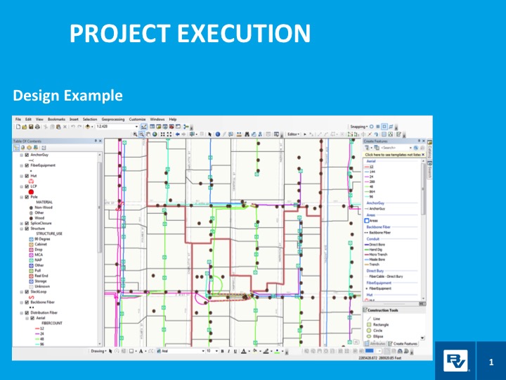
In a case study, he will take webinar attendees through a FTTH project design and execution example.
Black & Veatch is an engineering, consulting and construction company with more than 100 offices worldwide, specializing in infrastructure development in power, oil and gas, water, telecommunications, government, mining, data centers, smart cities and banking and finance markets.
FTTH project: fiber to the home. (Image: Black & Veatch)
The annual Black & Veatch Strategic Directions: Smart Cities & Utilities Report explores progress made across the smart city and smart utility landscape. This year’s report examines how modern, digital infrastructure is being used to optimize operations and create a sustainable future for our cities and utilities.
“From urban mobility to the proliferation of electric vehicles, transportation is changing rapidly, inviting opportunity in how people and goods move across cities. The next generation of wireless technology is upon us, further encouraging connectivity and enabling smart cities in myriad ways. Grid modernization continues as utilities work to create a customer-centric grid through a combination of smart devices, distributed energy and communications.”
Advances in aerial imagery including high-resolution maps and a streamlined process to capture, manage and deliver imagery in the cloud is transforming the way governments and businesses operate. With Aerial photography and instant access to current 2.8-in. GSD aerial views, Black and Veatch has increased efficiency in their telecommunications projects including assessment of ground conditions, construction and asset management. In Indiana, The City of Carmel’s Engineering Department has applied aerial imagery to enhance planning, operations and storm water management.
In this webinar, you will:
Learn about the latest advances in aerial imagery including how imagery is supporting a variety of government and business applications today
See real-world use cases of imagery in telecommunication, engineering and city government to improve operational efficiency
Understand how imagery can be used standalone and within GIS and CAD products
See the latest demos of Nearmap imagery including vertical, panorama and oblique views
Qualcomm Technologies Inc., a subsidiary of Qualcomm Incorporated, announced several automotive agreements at the Consumer Electronics Show (CES) 2018, at North Hall Booth 5616. The show took place Jan. 9-12 in Las Vegas.
As the automotive industry advances toward 5G, highly advanced connectivity solutions are needed to support road safety, mission critical applications, as well as advanced capabilities, such as autonomy.
With the Qualcomm Snapdragon automotive platform’s integrated GNSS and automotive dead reckoning, future vehicles are expected to have the increased capability to effectively be aware of its surroundings.
2017 Jaguar Land Rover. (Photo: Jaguar)
Jaguar Land Rover.Jaguar will use the Qualcomm Snapdragon automotive platform in the Land Rover to power highly advanced telematics, infotainment and digital cluster with integrated connectivity and rear-seat entertainment. The platform will help meet the demand for rich, immersive and seamless connected in-vehicle experiences in future Jaguar Land Rover vehicles.
For telematics units, Jaguar Land Rover will use the Snapdragon 820Am automotive platform to provide customers with ultra-quick and efficient connectivity throughout the vehicle by integrating 4G LTE Advanced, Wi-Fi and Bluetooth technologies.
As Qualcomm Technologies’ most advanced automotive solution, the Snapdragon 820Am Automotive platform features a custom-built 64-bit Qualcomm Kryo CPU, custom-built Qualcomm Adreno 530 GPU for virtualization advantages, and Qualcomm Hexagon 680 DSP Vector eXtension to stream high-definition videos seamlessly onto multiple displays.
It also features the Snapdragon X12 LTE modem to support Category 12 speeds up to 600 Mbps download, as well as vehicle sensor integration and computer vision to support driver assistance using the Snapdragon Neural Processing Engine.
2018 Honda Accord.The 2018 Honda Accord features the Snapdragon Automotive Platform to power applications for its in-vehicle infotainment and navigation system. The 2018 Honda Accord also features a Qualcomm 4G LTE modem designed to support the Hondalink vehicle connectivity system.
BYD Electric Vehicles. Chinese new energy company BYD Company Ltd. also selected Qualcomm Technologies’ automotive solutions for its upcoming electric vehicles. Anticipated to begin in 2019, BYD electric vehicles will feature integrated infotainment and digital cluster systems powered by the Qualcomm Snapdragon 820A Automotive platform.
The software architecture, hypervisor support and integration capability of the 820A supports BYD’s efforts to integrate its infotainment and digital cluster systems into a single electronic control unit (ECU). This is designed to deliver significant optimization and integration benefits compared to previous architectures, which used several different ECUs within the vehicle.
Qualcomm Technologies’ automotive solutions help improve power efficiency within the integrated ECU, which aids in enhancing the vehicle overall performance, battery life and driving range. The use of Qualcomm Technologies’ integrated infotainment and cluster system with Snapdragon 820A Automotive platform is designed to support a unified user interface, improvement in contextual awareness, and a rich in-vehicle user experience with multimedia.
Visteon Cockpit.Visteon Corporation plans to deliver the next-generation of its SmartCore cockpit controllers using automotive solutions from Qualcomm.
Future SmartCore cockpit controllers will feature the Qualcomm Snapdragon 820A Automotive platform to support automakers’ demand for highly advanced virtual cockpit controllers, which Visteon will design to support autonomous driving technology and applications.
Visteon’s SmartCore domain controller, which can independently operate several cockpit domains on one system-on-a-chip (SoC) through a single driver interface, will be the first platform-based domain controller to incorporate the Snapdragon 820A Automotive platform.
Using Snapdragon automotive solutions from Qualcomm Technologies, Visteon aims to make available technologies to support advanced virtual cockpits and autonomous driving through Visteon’s scalable hardware and software stack in SmartCore and its DriveCore autonomous driving controller.
DriveCore is an open platform consisting of the hardware, middleware and frameworks to develop machine learning algorithms for object classification, detection, path planning and execution.
Visteon is scheduled to launch the first SmartCore-based solution in 2018 on a high-volume, global vehicle platform with a European automaker.
Avenza Maps 3.4 for iOS and Android is now available. It contains new features and performance improvements, including the ability to add and manage new symbols to aid users in customizing their Avenza Maps experience with a built-in collection of U.S. National Park Service recreational symbols.
Release highlights include enhanced support for point symbology. Also, users can package their own PNG symbols as (KMZ) files, import and use them in the app.
Add and manage symbols. Avenza Maps Pro users can import and manage readily available collections of industry specific sets of symbols. such as the EMSINA Australasian All Hazards Symbology Set and the U.S. National Wildfire Coordinating Group GIS Standard Operating Procedures (GSTOP) Incidents Point Symbols. These symbol sets can be downloaded directly from the Avenza Support Centre.
Add placemark workflow improvements. Improved add placemark workflow and screen to accommodate symbol selection and make it easier to add photos. The Add Placemark screen now appears every time the Add Placemark icon is tapped from the map view screen.
This allows the user to conveniently change the symbol (or use the default one) as well as add any necessary information such as photos or collect data in a schema. Several of the most recently used symbols are listed for quick selection. A default symbol can still be set for the layer so one symbol can always be chosen.
Located in low, gently rolling hills just north of Indianapolis, Carmel, Indiana is one of the fastest-growing communities in the country. It has nearly tripled in population since 2000 and now numbers 91,000 inhabitants.
Considering the growth expected for 2017 and 2018, the City of Carmel needed a visual tool better able to manage the city’s expansion projects across several government departments.
After years of using low-resolution aerial imagery provided by the county, the City of Carmel realized it needed something better for analyzing and displaying accurate information.
The Carmel Storm Water Department turned to Nearmap to provide high-quality aerial images that are frequently updated to integrate with its existing applications, including ArcMap and ArcGIS.
Nearmap now supplies the city with high-resolution imagery that aids data accuracy, verifies customer claims, educates developers, enforces compliance, and prepares presentations for internal government meetings. As an unexpected bonus, since implementing Nearmap, the department has collected $60,000 more in revenue in 2017.
Shane Burnham, a GIS technician, and John Thomas, storm water administrator, both with the City of Carmel Engineering Department, will give a presentation on the city’s use of aerial imagery in a webinar on Thursday, January 18. The webinar is free, but attendees must pre-register.
Burnham provides GIS services for City of Carmel’s Engineering and Planning departments. He serves as departmental Cityworks Administrator and asset management specialist and has published custom GIS web applications during his career. Thomas focuses on impervious surface analysis using aerial imagery and GIS data in support of storm water administration and billing.
“Truth on the Ground is Best Seen from the Air: How aerial imagery is propelling government and commercial organizations to higher levels of operational efficiency” will also feature speakers from Black & Veatch, an engineering, consulting and construction company with more than 100 offices worldwide, specializing in infrastructure development in power, oil and gas, water, telecommunications, government, mining, data centers, smart cities and banking and finance markets; and from Nearmap, an international provider of high resolution aerial imagery.
Carmel Courthouse. (Photo: City of Carmel, Indiana.)
Carmel was named Number 1 among Niche’s “Best Places to Live in 2017”. Niche is a website that analyzes public data sets and reviews to produce rankings, report cards, and profiles for every K-12 school, college, and neighborhood in the U.S.
Advances in aerial imagery including high-resolution maps and a streamlined process to capture, manage and deliver imagery in the cloud is transforming the way governments and businesses operate. In this webinar, you will:
Learn about the latest advances in aerial imagery including how imagery is supporting a variety of government and business applications today.
See real-world use cases of imagery in telecommunication, engineering and city government to improve operational efficiency.
Understand how imagery can be used standalone and within GIS and CAD products.
See the latest demos of Nearmap imagery including vertical, panorama and oblique views.
Makers of the mobile GIS app SuperSurv, developed by Supergeo Technologies Inc., are working to increase its GNSS positioning functionality.
In recent weeks, the SuperSurv product team began to enhance SuperSurv’s NTRIP solution, aiming to adopt more RTCM versions and provide a better GNSS positioning service. NTRIP (Networked Transport of RTCM via internet protocol) is a protocol to send GNSS-related data through the internet, which enables users of differential GPS or network RTK to get correction parameters after connecting to the internet. The correction parameters can be used to calculate a more accurate GNSS location.
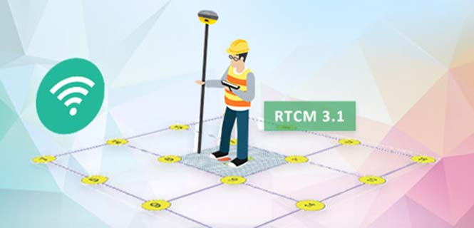
Supergeo’s product team is developing the support for RTCM 3.1, including Type 1021 and 1023, two kinds of messages. Type 1021 contains the seven parameters for 3-axis coordinate transformation — three for 3-axis translation, another three for 3-axis rotation and a scale factor.
Through the original projection method, users can only get rough coordinates. However, with NTRIP solution, users can send the current location to the server and then receive the parameters provided by it. This makes it easier to obtain a suitable local coordinates frame for more precise coordinates.
The Type 1023 message provides more accurate grid residuals. By establishing a 4 x 4 mask window around the rover, users will receive the 3-axis corrections within these 16 grids. Accordingly, a more accurate GNSS positioning is achievable after interpolation.
Image: SuperSurv
After completing the development, this technique will be implemented in the current version, SuperSurv 10.1. Combined with SuperSurv’s existing GIS features, Supergeo believes the newly supported RTCM 3.1 will bring a brand-new experience to fieldworkers.
Launched in November 2017, current version 10.1 offers three major new features, including snapping, coordinate system customization and Layerset. Google Maps and TIFF are also supported.
Supergeo’s product manager for mobile GIS, Zara Yu, recommend that users activate the point-data auto-collection with RTCM 3.1. This method not only helps users skip repeated operations but also enhances the data quality and efficiency.
By Jason Penkethman, Chief Product Officer at Spireon
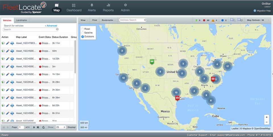
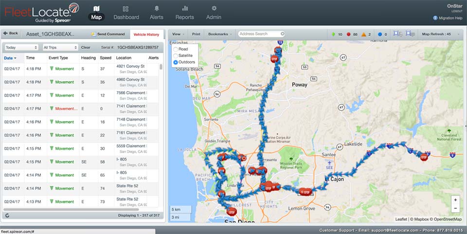
Fleets looking to take their operations to the next level look to GPS solutions for the obvious benefits — driver/vehicle location tracking, driver behavior monitoring, improved efficiency — and some that are not so obvious, such as making a positive impact on the environment.
“Going green” can be an arduous task, requiring constant calculations and adjustments to ensure that a fleet’s reduced environmental impact doesn’t negatively affect normal operations.
Fortunately, GPS fleet management solutions have come a long way and go far beyond simple geolocation. We live in an age where technology empowers fleet managers to go green – both environmentally and fiscally. And with effective communication and transparency, even drivers who once may have perceived fleet tracking as “big brother” are now seeing how joining the green initiative puts green in their own pockets.
The Case for Smarter, Eco-friendly Workdays
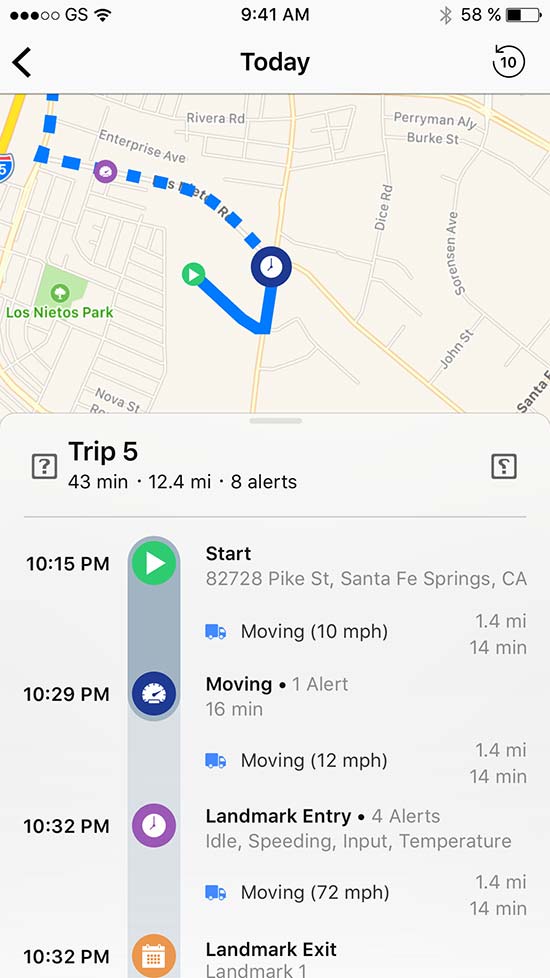
No matter the size of the fleet, reducing unnecessary drive time saves time, gas, and reduces carbon footprint. When last minute changes or emergencies arise, fleet tracking allows managers to dispatch the nearest driver for faster, more effective resolution. Fleet tracking also allows better planning of a driver’s day with proximity as a guide.
Image: Spireon
Eliminating Paper Waste. To properly manage a fleet, there is a seemingly endless stream of logs and diagnostics for drivers, cargo, vehicles and more. Implementing GPS tracking will cut back on the paperwork for managers and drivers alike by automating what once were manual processes and making compliance with new federal regulations such as the ELD mandate and the Food Safety Modernization Act a breeze.
Cutting Unnecessary Emissions. Idling and abrupt acceleration or braking are the biggest culprits of wasting gas and producing excess emissions. Thanks to GPS logging, these can be avoided as feedback is provided to fleet managers and drivers, allowing active awareness for better driving habits.
Better Maintenance, Better Mileage. Second to employees, vehicles are a fleet’s most important asset, and both need proper attention and care to succeed! While drivers can tell a fleet manager what they need, many vehicles won’t until it’s too late. With modern GPS devices, diagnostics are constantly run, keeping fleets informed and instantly aware of upcoming maintenance or surprises to keep drivers safe and vehicles running at maximum efficiency.
Creating Driver Advocates
While the benefits of GPS fleet tracking seem clear, overcoming driver apprehension sometimes causes pause for the business owner looking to implement a solution.
However, drivers can become GPS’ greatest advocates with clear communication and transparency. It’s important to explain that GPS tracking works to a driver’s advantage when there are records of driver performance in the event of an accident, medical emergency or crime.
Fleet managers can use the data to support drivers if they are accused of wrongdoing by customers or an insurance company. Additionally, the system can be used to offer incentives including higher base pay, recognition or bonuses to the best performing drivers.
Fleets should convey that the main goal of GPS is not to point fingers at drivers or to spy on them, but rather to make the business enterprise more efficient and competitive.
Part of the process necessarily means an overall improvement in their working conditions such as not having to call them all the time to keep track of their positions, sending the closest convenient driver to a location, establishing routes and schedules that are manageable and — yes — monitoring their behavior.
This, however, is an incentive to keep drivers under the speed limit and make them feel more responsible — not least, protecting against legal and safety issues. In our experience, good employees have no problem with accountability and, in fact, welcome it as it sets them apart from less productive co-workers.
Greenery on the Scenery
Fleet tracking also helps to explain the savings in company costs made on fuel, maintenance and administration jobs.
Fleet managers should explain to drivers how the new process can generate bonus programs, reduce customer call-backs, cancellations, complaints and paperwork (for timecards) and improve upon driver training.
GPS will make for a better company with benefits everyone should realize and readily appreciate. The healthier the company, the more secure the jobs within it. Everyone benefits from a fatter bottom line, and job security is nonexistent without profitability. Helping drivers to understand why the fleet is adopting the solution will help recruit them toward a positive outcome.
Whether a fleet business is interested in going green for the environment, or for its own profitability, GPS tracking solutions — and gaining driver buy-in — create a powerful catapult to achieving goals rapidly and effectively.
Jason Penkethman is chief product officer at Spireon and is responsible for leading innovation in the company’s products and platform, and creating vehicle connectivity solutions to maximize customer value.
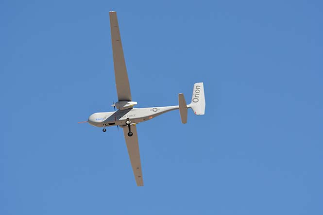
The U.S. Air Force has awarded a $48 million contract to Aurora Flight Sciences for the continued development of the Orion unmanned aircraft system (UAS). Aurora Flight is a Boeing company.
Orion is a twin-engine high-performance UAS that can stay aloft over 100 hours at a time with payloads in excess of 1,000 pounds.
Development of the Orion started in 2006 and its first flight was in August 2013. In December 2014, the Orion established the UAS world endurance record with an 80-hour, 2-minute and 52-second flight.
The new contract funds the development of a certified version of Orion that will be suitable for deployment anywhere in the world. The work will be performed in Columbus, Mississippi, and Manassas, Virginia.
Boeing completed the acquisition of Aurora Flight Sciences in November 2017.
Renesas will use NovAtel’s high-performance SPAN tightly coupled GNSS and inertial navigation system (INS) technologies with GNSS correction services for live autonomous vehicles and advanced driver assistance systems (ADAS) demonstrations throughout CES.
SPAN GNSS+INS products provide position, orientation and time solutions that are critical for autonomous applications.
NovAtel’s assured positioning technology not only delivers solutions based on signals from satellite constellations but also uses vehicle behavior modelling, inertial sensor integration and GNSS correction signals to improve accuracy and significantly reduce interruptions in availability.
Image: NovAtel
Renesas relies on NovAtel products to provide high integrity and accurate positioning for autonomous driving, ADAS, connected car feature demonstrations and automotive solutions that will be showcased at CES 2018.
With the commitment to ensure autonomous vehicles have assured positioning solution, a team of engineers formed the Safety Critical Systems Group at NovAtel to meet the exceptional performance and safety requirements of autonomous vehicles at the necessary production volumes and price point required.
Since its formation, the group has made many positive partnerships in the automotive industry.
NovAtel and Renesas are currently collaborating on implementing NovAtel’s high-performance GNSS+INS positioning solution with the Renesas R-Car H3 system-on-chip (SoC). The R-Car H3 is compliant with the ISO 26262 functional safety standard for automotive applications, which aligns with NovAtel’s automotive strategy.
NovAtel has a long history providing industry leading high-precision GNSS solutions that are high quality and reliable. As an ISO 9001 certified company, NovAtel is also developing an extensive product line of receivers, antennas, correction signals, positioning algorithms, sensor fusion solutions and systems that fulfill specific safety requirements of the automotive industry such as ISO 26262.