Click to read a roundup of recent products in the GNSS and inertial positioning industry from the September 2025 issue of GPS World magazine.
Category: Applications
-

User-friendly GNSS software meets high-precision mobile mapping for modern surveying
1. Dat Collection Software
Intuitive workflows require minimal trainingJAVAD Data Collector (JDC) is designed to run seamlessly on any Android device and interface seamlessly with JAVAD GNSS smart antennas. JDC features simple, intuitive workflows that require minimal training, making it accessible for users of all skill levels. The software includes a Signal Bar for a quick view of receiver status, ensuring users can easily monitor their equipment’s performance. Its easy navigation allows users to move through the software efficiently. It is designed to streamline operations of customers ranging from individual surveyors to large surveying firms, making it easier to deploy and manage receivers across teams of any size with minimal training. JDC is available for download through the company website. JAVAD GNSS, javad.com
2. Mobile Mapping System
Lidar collects 2 million points per second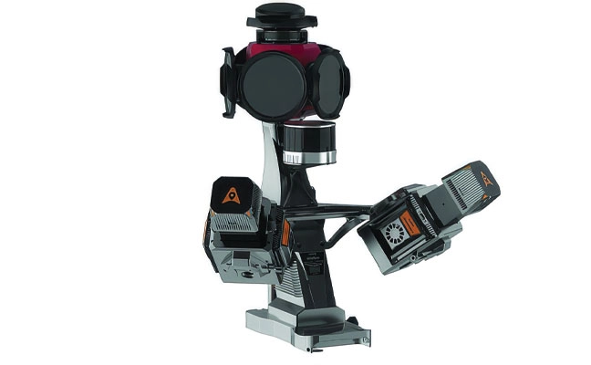
Photo: CHC NAVIGATION The AU20 MMS is a vehicle-mounted mobile mapping system designed for accurate and efficient collection of 3D spatial data. It combines high-performance lidar technology, versatile sensor support and intelligent data processing to provide a practical and flexible solution for professionals in road surveying, asset management and infrastructure documentation. Its lidar system uses fourth-generation real-time waveform processing to achieve a scan rate of 2 million points per second and 200 revolutions per second, producing point cloud data with 5 mm accuracy and 3 mm precision. This level of detail allows for the identification of fine surface characteristics and features, supporting comprehensive asset inventories and condition assessments. The system’s long-range, multi-cycle laser technology enables high-density data capture up to 250 m in vehicle-mounted applications. CHC Navigation, CHCNAV.com
-

Value line steering solution upgrades mid-range tractors with autosteering
1. AUTONOMOUS STEERING PACKAGE
Allows upgrades of older machinery for small farms
Topcon’s has created a Value Line Steering solution for farmers using mid-range tractors on small- to medium-sized farms. It makes autosteering technology — typically used on larger machinery — accessible to a broader range of farmers. Farmers with older or smaller machinery, or small specialty farms, can boost the value of their machinery with the autosteering technology. The integrated system is designed to work across a wide range of applications, machinery and brands. It includes compliance with ISOBUS-UT to offer universal compatibility and ease of use. The package includes a GNSS receiver, electric steering wheel controller, touchscreen console and Horizon Lite software, compatible with front-wheel-steer tractors. Farmers can add local, satellite or RTK correction services such as Topcon’s Topnet Live for enhanced precision. Topcon, topconpositioning.com
-
Teledyne Optech to showcase mapping and marine technologies at INTERGEO 2025
Teledyne Optech will showcase its portfolio of solutions designed for topographic and marine mapping and electric utility inspection at Intergeo 2025, taking place Oct. 7-9 in Frankfurt, Germany. The company will exhibit at Hall 12.0, Stand 0C067.
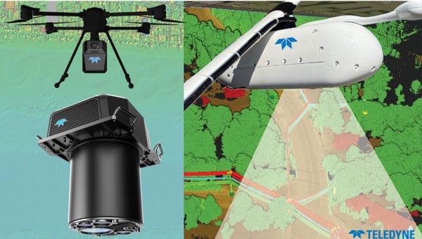
Featured technologies will include Fathom, a topo-bathymetric airborne lidar system designed for data integration of topo lidar, bathy lidar and a multispectral camera capturing the coastal scene from dry land to below water. Also on display will be EchoONE, Optech’s smallest lidar sensor to date at just 1.65 kilograms, combining long-range performance with NDAA compliance and real-time generation of georeferenced point clouds. Visitors will also see Network Surveyor, powered by Galaxy Edge and designed to meet the time constraints of electric utilities, featuring real-time processing and a software analytics stack for utility operators.
Visitors are invited to view a new compact lidar sensor designed for integration in modern wing and belly pods. Deployable in lightweight aircraft and helicopters, the sensor delivers high resolution for mapping projects, utility asset management and vegetation monitoring. Teledyne Optech will host a reception Tuesday, Oct. 7, from 4-6 p.m. at the stand.
The booth will also showcase Teledyne Marine’s sonar and software solutions for marine infrastructure projects, including dredging, offshore wind and port and harbor operations. Live demonstrations of Teledyne FLIR IIS’ spherical imaging camera Ladybug 6, with spatial accuracy of plus or minus 2 millimeters at 10 meters distance, will be available.
Mike Lee, director of product management at Teledyne FLIR IIS, will speak Tuesday, Oct. 7, from 12:50-1:10 p.m. on “Beyond Resolution: Advancing Mobile Mapping Through Spherical Imaging Innovation.”
Teledyne Optech is a lidar solutions provider. With operations and staff worldwide, Teledyne Optech offers solutions for topographic and marine mapping, defense and electric utility inspection.
-

Four innovations strengthening navigation resilience against RF interference
1. Anti-jamming antenna
For defense, marine and critical infrastructureThe CR8894SXF+ is an advanced controlled reception pattern antenna (CRPA) for anti-jamming. It is engineered to provide efficient interference protection and real-time situational awareness across critical infrastructure, marine and defense environments where GNSS continuity is mission critical. It is specifically designed to provide a low-power and lightweight solution in a compact size. It features advanced in-band null forming to protect GPS L1/L2 and Galileo E1/E5b signals, helping ensure resilient positioning, navigation and timing in environments with contested, congested or degraded radio frequency conditions. The antenna incorporates Calian’s eXtended Filtering interference mitigation technology to maintain performance and reliability when RF threats are present. The CRPA supports in-band null-forming of 20 dB to 40 dB and out-of-band rejection up to 80 dB across 700 MHz to 2,500 MHz. It includes two independent low-noise amplifier channels, allowing continued operation if one signal band is compromised. The antenna forms nulls in both upper (L1/E1) and lower (L2/E5b) GNSS bands to actively suppress jamming sources. A serial output interface provides real-time feedback, enabling users to monitor RF conditions and system status. Calian GNSS, calian.com
2. PNT system
Integrates GNSS receiver, INS, atomic clock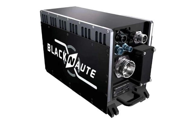
Photo: Safran The BlackNaute autonomous positioning, navigation and timing (PNT) system integrates Safran’s HRG dual-core inertial navigation technology, the Skylight multi-mode GNSS receiver board, and an atomic clock to offer navigation resilience in challenging electronic warfare environments. BlackNaute’s built-in atomic clock is designed to maintain precise timing, which is essential for secure communications and collaborative combat operations. The system features advanced anti-jamming and anti-spoofing algorithms, which have been validated in more than 16,000 operational cases. These capabilities allow BlackNaute to detect compromised signals and automatically switch to autonomous and trusted navigation and timing sources to ensure continuity of operations. Its modular design allows it to be adapted across a variety of platforms. Airbus Helicopters has selected the NH90 to be equipped with this new Embedded GNSS and Time INS (EGTI). Safran Electronics & Defense, safran.com
3. Interference detection
Suite enhanced for greater accuracy, coverage and insight
Photo: US Navy HawkEye 360’s GNSS-I Detection suite includes powerful enhancements to its GNSS interference detection capabilities. The upgrades — designed with defense, intelligence and national security operations in mind — offer unprecedented accuracy, coverage and insight into global GPS jamming and spoofing threats. The update includes a new wider frequency algorithm that better distinguishes individual emitters, incorporates GPS spoofing detection, and is terrain adjusted for better geolocation accuracy, delivering greater situational awareness and more precise geolocation of interference sources worldwide. The enhanced product suite supports strategic decision-making by providing timely, precise insight into potential signal disruptions, enabling stakeholders to better assess risk, respond confidently, and maintain operational continuity in dynamic environments. HawkEye 360, he360.com
4. VTOL UAS
For complex intelligence, surveillance and reconnaissance missions
Photo: ESEN The GöKHUN unmanned aerial system (UAS) is a tactical vertical take-off and landing (VTOL) drone system developed for versatile missions on land or at sea. GöKHUN combines the compact mobility of a NATO Class I UAV with the performance data of a Class II tactical system. It uses the SP 210 FI GS 2-stroke engine from Sky Power International. With a take-off weight of up to 110 kg and a maximum fuel and payload capacity of 26 kg, the GöKHUN can remain in the air for up to 16 hours with a minimum payload. Even with a demanding sensor load of 12 kg, it can achieve a flight duration of around nine hours, making it suitable for long-endurance reconnaissance and surveillance missions. The GöKHUN’s cruising speed is between 96 and 158 km/h. The maximum range with direct line-of-sight is over 150 km, with the system reaching a service ceiling of approximately 5,500 m. ESEN, esensi.com.tr
-
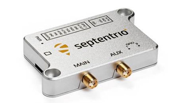
Septentrio starts mass production of mosaic-G5 modules
Septentrio, part of Hexagon, has started volume shipments of its mosaic-G5 modules. Measuring 23 mm by 16 mm and weighing 2.2 g, mosaic-G5 enables reliable positioning without performance compromises for commercial UAVs, robots, geographical information system devices (GIS) and many other size and power-constrained industrial applications. The company’s GNSS technology provides enhanced positioning availability in challenging environments where signals are degraded or obstructed.
“We have had a lot of interest in the mosaic-G5 module series since its announcement earlier this year. After successful beta testing with various customers, I am pleased to say that we have now started shipping volume orders,” commented François Freulon, director of product management at Septentrio.
The mosaic family offers users a range of receiver modules to balance performance and cost. The quad-band mosaic-G5 P3 and the triple-band heading module mosaic-G5 P3H provide positioning availability in challenging environments for applications such as mapping or light show UAVs. The modules complement the mosaic product line, including the mosaic-X5 receiver, which the company positions as a benchmark for GNSS open-signal anti-jamming and anti-spoofing² resilience in a small form factor.
The mosaic-go G5 evaluation kit is available through the Septentrio webshop for testing and prototyping. It offers direct autopilot connections, and the free RxTools user interface assists with setup and evaluation.
Septentrio will showcase the mosaic-G5 modules at Intergeo in Frankfurt, Germany, Oct. 7-9, in Hall 12, Booth 114.
-

Mayflower receives US patents for signals of opportunity anti-jamming tech
Mayflower Communications Company, a Massachusetts-based leader in advanced anti-jam system solutions for military and commercial markets, has been granted two U.S. patents — US 11,262,457 and US 12,235,365 — that significantly advance its GNSS anti-jam capabilities.
The patents expand Mayflower’s proprietary technology into signals of opportunity (SoOP), enabling interference suppression across both Iridium and GNSS frequency bands.
GPS remains a cornerstone of positioning, navigation and timing (PNT) for both military and commercial platforms. However, its vulnerability to intentional and unintentional jamming and spoofing has underscored the need for more resilient PNT solutions. Signals of opportunity — non-navigational RF signals not originally intended for PNT — can serve as valuable backups when GPS signals are degraded or denied. But like GPS, these signals are also susceptible to interference and require protection to be viable contributors to a resilient PNT framework.
Mayflower’s newly patented technology provides simultaneous protection of GPS and Iridium satellite signals within a compact, low size, weight and power (SWaP) footprint — critical for modern platforms operating in GPS-contested environments.
“The issuance of these seminal patents by the U.S. Patent and Trademark Office affirms Mayflower’s continued leadership in resilient PNT technologies for both military and commercial markets,” said Triveni Upadhyay, president of Mayflower. “Our innovative approach to filtering interference across multiple satellite communication systems — including Iridium — demonstrates our ability to meet the growing demand for GPS-alternative solutions. Leveraging signals of opportunity without significantly increasing SWaP is a key milestone in delivering more robust, operationally viable PNT systems. We’re excited to bring this technology to our partners across sectors.”
-

CMC Electronics and ÉTS launch major research chair in resilient aviation navigation
A five-year research and development program has been launched to enhance GNSS navigation for aviation, encompassing security, integrity and spoofing resilience.
CMC Electronics is partnerinng with École de Technologie Supérieure (ÉTS) in Quebec, Canada, to create the CMC Electronics Industrial Research Chair in Resilient GNSS Navigation. The five-year chair, valued at more than $6 million, unites CMC’s avionics expertise, led by John Studenny, internationally recognized GNSS navigation expert and standards contributor, with ÉTS’s renowned LASSENA laboratory under René Jr. Landry, an expert in aerospace navigation and cybersecurity.
The chair will tackle critical threats to GNSS navigation for aviation, including jamming and spoofing. CMC and ETS aim to develop spoofing-resilient GNSS receivers capable of real-time detection, mitigation and total recovery from spoofing attacks, setting a benchmark in aviation safety and integrity.
Research focus areas
The chair’s work spans several integrated areas that target key GNSS security challenges:
- integration of spoofing detection algorithms
- spoofing resilience grading and stress testing frameworks
- recovery mechanisms and certification benchmarking
- advanced integrity algorithms (ARAIM)
- sensor fusion and authentication technologies for spoofing mitigation
- end-to-end spoofing-resilient GNSS prototype
- next-generation inertial sensors with built-in integrity
Together, these areas aim to produce operational, spoofing-resilient GNSS systems suitable for aviation environments.
Broader impact and strategic alignment
The chair will train more than 65 highly qualified personnel (HQPs) and promote equity, diversity and inclusion in engineering. It supports initiatives to increase women’s representation and aligns with ÉTS’s strategic research fields in aerospace, cybersecurity, sensors and intelligent autonomous systems.
CMC Electronics is co-leading the research program and industrial deployment, ensuring that the outcomes are fast-tracked toward secure, export-ready GNSS solutions. Safran Trusted 4D contributes specialized expertise, and Jaunt Air Mobility provides operational insights for flight testing and system integration.
-
Maxar Intelligence rebrands to Vantor, unveils AI-powered platform
Vantor has rebranded from Maxar Intelligence. The newly named company also unveiled Tensorglobe, an AI-powered spatial intelligence platform.
The rebrand represents the culmination of the company’s multi-year journey to productize its core operational technology and transform from a satellite imagery provider into an end-to-end spatial intelligence company.
According to the company, the name Vantor speaks to how the company unlocks a real-time competitive advantage by delivering total clarity for missions across the space, air and ground domains, ending the era of disconnected sensor platforms. “Vantor is solving the most critical challenges across the defense and commercial sectors, including the urgent need for more advanced battlespace systems and the push to unleash autonomy across every industry,” the company said in a press release.
The company addresses these challenges with multi-domain spatial intelligence solutions that integrate sensor data across satellites, drones and ground-based assets to improve decision-making and drive autonomous operations at scale. Over the past six months, Vantor has launched several AI-enabled solutions, including:
- Raptor: A software suite that integrates Vantor’s 3D terrain data with a drone’s native camera to ensure that autonomous platforms can navigate effectively and extract target ground coordinates accurately in the absence of GPS.
- Sentry: A global-scale persistent site monitoring solution that can identify operational threats across hundreds of areas at once by integrating automated collection planning across multiple satellite constellations, including sovereign assets, with AI-driven data fusion and analytics.
- Tensorglobe: An end-to-end platform that empowers organizations to build their own spatial intelligence system. Tensorglobe fuses sensor data from space, air and ground to create a living 3D globe, automating the intelligence cycle to keep this unified foundation up to date.
Vantor has partnered with innovators across the defense and commercial sectors to jointly build integrated intelligence solutions. For instance, Vantor is delivering the foundational spatial intelligence for Anduril’s next-generation mixed reality combat system designed for the U.S. Army’s Soldier Borne Mission Command Architecture (SBMC-A) program. The company has also signed partnerships with Saab and Taiwan’s AIDC to integrate Raptor into mission-ready systems designed for contested environments.
-

Topcon launches Geomatics division ahead of Intergeo
Topcon Positioning Systems has created of a dedicated business structure focused on delivering high-precision technology, software and services for geomatics. The new organization consolidates and expands Topcon’s portfolio of surveying, geospatial and GIS solutions, while opening new pathways into emerging markets.
The specialized division is an addition to the company structure, which includes established divisions dedicated to construction and agriculture.
“Geomatics is entering a new era,” said Ivan Di Federico, president and CEO of Topcon Positioning Systems. “It is no longer only about collecting points and producing maps. Today, it is about capturing massive amounts of geospatial data, connecting multiple data streams, and delivering insight with the speed and simplicity our customers demand. Topcon’s role is to reduce the gap between field capture and business decisions. By elevating geomatics into its own global business group, we are signaling that this discipline is vital — not just for traditional professionals, but for every sector where spatial intelligence drives efficiency and growth.”

Neil Vancans will lead the new Geomatics Sales Unit of Topcon. (Photo: Topcon) Neil Vancans, an experienced leader in the surveying and geospatial industries, has joined the company as the head of its new Geomatics Sales Unit. He brings decades of experience in senior leadership roles at companies including Leica Geosystems, Thales Navigation, Septentrio, and Altus Positioning Systems.
“Topcon has the precision technology, the global resources, and the vision to reshape what users can expect from geomatics,” Vancans said. “The demand for accurate, reliable positioning is expanding rapidly, and our goal is to turn raw data into usable, actionable intelligence. That means creating value for customers, empowering dealers and partners, and ensuring that geomatics solutions accelerate digital transformation.”
Topcon geomatics solutions — including the expanding Capture Reality portfolio — will be showcased at Intergeo 2025 in Germany, Oct. 7-9.
For more on Topcon’s focus on precision, watch the video “Since Precision Exists.”
-

Are you ready for NSRS modernization? What the upcoming changes mean for your geospatial data
In my August 2025 GPS World newsletter column, I highlighted that a colleague reminded me that the National Geodetic Survey’s (NGS) new National Spatial Reference System (NSRS) is more than a technical upgrade. It offers a prime opportunity to review and improve current processes and workflows, examine existing products and considerations, and plan strategically for future needs. By auditing geospatial data dependencies now, NSRS users can assess how transitioning to the new datum will affect workflows, datasets and operational decision-making.
Several organizations have formed working groups to address the new NSRS. The National Society of Surveyors (NSPS) has released a story map to inform the professional surveying community and is developing guidance and case studies. The American Association for Geodetic Surveyor (AAGS) is collaborating with NSPS. The American Society of Photogrammetry and Remote Sensing (ASPRS) has prepared materials available on its website. Additionally, under the leadership of Gary Thompson, the North Carolina Geodetic Survey established the North Carolina 2022 Reference Frame Working Group. The group’s goal is to address issues related to the implementation of the datum change in 2026. It includes representatives from North Carolina agencies involved in producing or using geospatial products and services.
Agencies Involved in the NC 2022 Reference Frame Working Group NC Geodetic Survey NC DOT Hydraulics NC State Mapping Advisory Committee NC Geographic Information Coordinating Council (GICC) NC State, Land Records Management NC Geodetic Survey Advisory Committee NC Center for Geographic Information & Analysis NC GICC Local Government Committee NC Society of Surveyors NC DOT State Location & Surveys NC State Mapping Advisory Committee Duke Energy NC DOT Photogrammetry Unit NC GICC Local Government Committee U.S. National Geodetic Survey The organizations participating in the NC RFWG are assessing how changes in the new NSRS may impact their geospatial workflows and evaluating their reliance on NGS products and services. Proactive self-assessment is essential because NGS cannot customize support for each entity’s unique needs and processes. By identifying potential challenges and opportunities early, organizations can adapt smoothly and maintain operational efficiency during the transition. The following were the key action items from the last NC RFWG meeting:
- Create an information sheet to help local governments prepare for the data change
- encourage agencies to consult their software vendors on support measures for the new datums
- establish a rule for when to use the U.S. Survey Foot versus the International Foot
- review current data files to ensure their metadata includes datum and unit information.
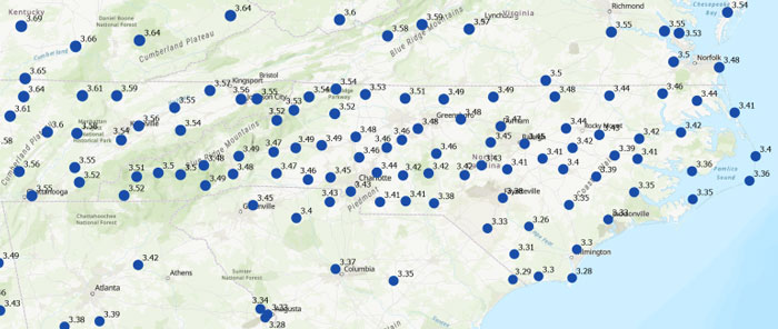
Many participants of the North Carolina working group expressed interest in understanding how much the coordinates will shift with the new NSRS. While NGS’s website offers diagrams that provide a high-level overview of coordinate and product changes, many users sought more detailed information specific to North Carolina. To address this, I used NGS’s Multi-Year CORS Solution 3 (MYCS3) update of the NOAA CORS Network to ITRF2020, epoch 2020.0, to estimate the changes between the current NSRS — NAD 83 2011 (epoch 2010.0) — and the upcoming NSRS in North Carolina, such as NATRF2022 at epoch 2020.0. This approach offers a more detailed view of the magnitude of shifts in local regions. The figure titled “Approximate Differences Between NATRF2022 (Epoch 2020.0) and NAD 83 2011 (Epoch 2010.0) in NC” illustrates the approximate horizontal coordinate differences between the current NSRS and the future NSRS based on NCN CORS data. (Note that these units are in feet.) For additional information on MYCS3 and regional changes across the United States, refer to my August 2025 GPS World column.
Approximate differences between NATRF2022 (Epoch 2020.0) and NAD 83 2011 (Epoch 2010.0) in North Carolina. Horizontal change in feet. (Credit: Dave Zilkoski) Differences in orthometric heights between the new NAPGD2022 and the current NAVD 88 are significant for anyone working with FEMA flood maps or preparing flood insurance elevation certificates. I used ITRF2020, epoch 2020.0, ellipsoid heights from NOAA CORS stations along with Geoid2022 values to estimate the NAPGD2022 orthometric heights at the CORS sites. As depicted in the plot, the height differences between NAPGD2022 and NAVD 88 across North Carolina range from about 0.5 feet in the southeastern region to over a foot in the northern and western regions. (Note that the units are in feet.)
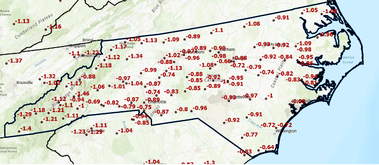
Approximate differences between NAPGD2022 and NAVD 88 in North Carolina. Orthometric height change in feet. (Credit: Dave Zilkoski) This type of information should be shared with managers of real-time GNSS networks(RTN). RTN operators could then establish a parallel beta system to enable users to understand how the new NSRS may affect their products and services. (Note: The North Carolina Geodetic Survey, which manages the NC CORS/RTN system, is considering running a pilot parallel RTN based on the new NSRS.) This data can be valuable for RTN users to assess how coordinate changes might influence their workflows. For example, it can help determine how the shifts in coordinates will affect agricultural activities such as planting, fertilizing and harvesting. Will farmers need to remap their fields, or will a transformation be sufficient?
Fostering collaboration with stakeholders and constituents will help users better understand how the NSRS modernization impacts their products and services. Developing strategies to align geospatial data management with regulatory requirements and operational objectives will also facilitate a smoother implementation process. NGS is partnering with federal agencies and professional societies to create a self-assessment guide that helps organizations evaluate how the NSRS update affects their geospatial missions. As previously mentioned, the North Carolina 2022 Reference Frame Working Group is working with state and local agencies, as well as surveyors, to proactively address key questions and challenges. This collaboration aims to improve communication with NGS and determine whether their products and services need to be reprocessed, re-surveyed or transformed to suit the new standards.
Each organization has its own unique geospatial requirements and a thorough understanding of its mission and needs. This is an ideal opportunity to develop a centralized plan for evaluating and managing geospatial workflows during the transition to the modernized NSRS. Challenges include aligning legacy datasets with new reference standards while ensuring data integrity. Organizations should assess the accuracy of their data in relation to the NSRS and document any necessary updates in metadata. By creating a well-structured plan that balances operational constraints, legal compliance and practical considerations, organizations can prioritize accuracy, efficiency and alignment with the updated NSRS.
To assist others in preparing for the new NSRS, Dana J. Caccamise II, NGS regional geodetic advisor, has developed guidance materials that have been shared with federal agencies — including the FGDC and their team leaders — and professional organizations such as NSPS, ASPRS and AAGS. See the boxes titled “Questions to Guide a Self-Assessment of Your Operation and Products” and “List of NGS Products and Services — Are your workflows dependent on one or more NGS products.” The goal is to help these agencies become ready to implement the new NSRS once it is officially adopted by NGS.
Questions to Guide a Self-Assessment of Your Operation and Products Are you generating or using geospatial data (or doing both)?
– If so, your workflows are likely dependent on geodetic control tied to one or more NGS products. The upcoming NSRS update will affect these dependencies. (See “List of NGS Products and Services.”)Do you know if your mission, project, or datasets depend on NGS products?
– Identifying whether and how your entity relies on NGS products is a critical first step in assessing potential impacts.What are your accuracy, precision, and shelf-life requirements for geospatial data?
– Understanding your mission’s specific data requirements ensures you can evaluate whether NSRS modernization will meet your operational needs without unnecessary adjustments. This should include plans to accommodate greater accuracy in the future.Do you know how your entity accesses and utilizes geospatial data?
– Are you obtaining it directly from NGS or indirectly through third-party vendors (e.g., RTN systems, GIS platforms, GNSS companies)?
– Have you considered how updates to NGS products may impact the tools or services you rely on from these vendors?
– Many entities rely on geodetic control without realizing it. NGS’s foundational data and frameworks are often invisible and seamlessly embedded within the tools and services offered by third-party vendors, such as GIS platforms, survey equipment, and software providers. These vendors, in turn, depend heavily on NGS products like the NSRS to ensure their tools are accurate and functional. Understanding this indirect reliance is crucial for preparing your workflows and ensuring continuity as the NSRS is modernized.Where does your entity fit in with the geodetic workflow?
– Does your entity create integral products (e.g., GNSS data, lidar data) on which other products depend?
– Does it produce derivative products (e.g., DTM, Topographic Map, Flood Insurance Rate Map (FIRM) and Flood Insurance Study (FIS) Report)?
– Evaluating these dependencies will help you determine the scope of NSRS modernization impacts.What are your project requirements for data accuracy and longevity?
– Assess whether your data accuracy thresholds and long-term usability align with the modernized NSRS.Have you evaluated workflows and identified potential impacts in areas affected by significant ground movement (e.g., regions with tectonic shifts, vertical land motion, and, most notably, subsidence)
– Identifying potential risk or disruption areas can guide prioritization and help mitigate impacts on critical operations.
List of NGS Products and Services
Are your workflows dependent on one or more NGS products
Products and Services Examples Geodetic Control Data – Datasheets
– State Plane CoordinatesSurvey
– MarksSurvey DataNational Spatial Reference System (NSRS) Datasets – Horizontal (Geometric) reference frames
– Vertical (Orthometric / Physical) datums
– Geoid ModelsNSRS Tools and Resources NGS Geodetic Tool Kit
– NGS PC Software such as ADJUST
– User-Contributed Software
– VDatum to convert elevation data
– Other NSRS Resources such as transformation toolsGNSS Data and Solutions OPUS (Online Positioning User Service)
– CORS (Continuously Operating Reference Stations)
– Satellite OrbitsGravity Data – Gravity for the Redefinition of the American Vertical Datum (GRAV-D)
– Deflection of the Vertical (DoV)Coastal Mapping Products – Topobathy lidar Data
– Shoreline Mapping ProductsAerial Imagery and Remote Sensing – NOAA Remote Sensing Division Products such as Emergency response imagery (e.g., hurricane damage) Analytical tools – Least squares analysis tool
– Antenna CalibrationsGIS and Visualization Tools – Geospatial Data such as Shapefiles and KML files for GIS applications
– Web ServicesEducational and Reference Materials – Documentation such as NGS technical reports
– Presentations and Posters
– User support such as NGS Information Center and Regional Geodetic advisorsHistorical Data Archives – Legacy Products such as Older geodetic survey records and Superseded geoid models and transformation tools Standards and Procedures, best practices, data formats – Standards and Procedures such as NOAA Technical Memorandum NOS NGS 92
– Data Formats such as GVX (Real-time or post-processed GNSS vectors)To support the increased awareness of the modernization of the NSRS, under the auspices of the Federal Geodetic Control Subcommittee, NGS will host a meeting with federal geospatial agencies on Oct. 15, 2025, to discuss the NSRS modernization. The primary objectives of this meeting are to:
- Increase awareness of the NSRS modernization rollout schedule and engagement strategy, including self-assessment and interaction between official departmental working groups.
- Within other departments, connect decision-makers to those who accomplish NSRS modernization tasks and designate points of contact to interface with NGS capacity building efforts.
- Share experiences and strategies among federal agencies concerning NSRS modernization self-assessment and preparation.
- Gather questions, discuss anticipated challenges and identify opportunities to support each other through this transition.
It is my understanding that this meeting is open to the public (virtually) for listening and observation. See below for more information on the meeting.
Federal Geodetic Control Subcommittee Meeting
- Date: Wednesday, October 15, 2025
- Time: 1:00 PM – 4:00 PM ET
- To attend virtually, here is the registration link

I recommend that NSRS users consult guidance from NGS and engage with professional societies that have established working groups to analyze the impact of the new NSRS on geospatial products and services. Getting involved now will help ensure you are prepared when NGS officially adopts the updated NSRS. As Dru Smith, NGS NSRS modernization manager, explained in his webinar titled “NSRS Modernization — Big Steps Forward and What Comes Next” on Aug. 14, 2025, once the initial set of products and services of the modernized NSRS is “official,” the new NSRS becomes “The NSRS,” and its implementation then begins.
Are you prepared to implement the new NSRS once NGS officially adopts it? Do you have the necessary tools and resources in place to support a smooth transition? This newsletter highlighted several actions that users can take now to ensure they are ready to implement the new NSRS when it becomes official.
-
Korea testing gridded VRS for better GNSS accuracy
South Korea has launched a test operation of a new GPS-based positioning service, reports the Korea Herald. The Gridded Virtual Reference Station (G-VRS) works without an internet connection to provide real-time location data with centimeter-level accuracy.
The G-VRS will complement the current VRS system for users in remote areas with unstable internet connections — islands, mountains or fast-moving vehicles.
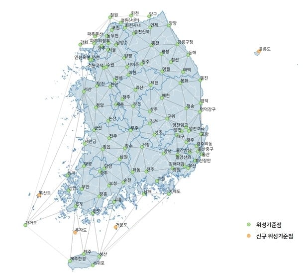
GNSS control points have been installed across the country, including four on Jeju Island and one in Gageodo, an island off the southwestern coast. The state plans to install additional points on four islands, including Ulleungdo, about 120 kilometers off Korea’s eastern coast, to operate 103 control points in total by the end of this year.