3Plus, a developer and manufacturer of smart wearable devices, will introduce four new connected products at CES 2016. The huge Consumer Electronics Show (CES) will be held in Las Vegas Jan. 6—9. The new 3Plus wearables line will be on display at CES 2016 in Tech West Sands Expo Booth no. 72745, and the ShowStoppers press event on Jan. 6.
From basic activity trackers to advanced smartwatches, all of the new 3Plus wearables track and record daily activity and sleep. They also use Bluetooth 4.0 to provide smartphone notifications such as calls, e-mails and text messages. They are compatible with both iOS and Android platforms and have corresponding mobile apps.
“Today, a wristwatch is more than just a means to know what time it is and the day’s date,” remarked Jerry Galya, 3Plus vice president of sales. “Digital technology has taken wristwatches in a whole new direction and 3Plus is right at the forefront with many innovative technologies. Our newest wearables are available at a variety of affordable price points depending on what features you are interested in. From the most basic smartphone notifications and fitness tracking, to advanced heart rate monitoring and call answering, 3Plus offers it all.”
The following 3Plus IoT wearables products will be introduced at CES 2016.
3Plus Lite: This connected fitness wearable tracks steps taken, calories burned, distance traveled, duration of sleep and sleep cycles. It has daily life reminders such as when to wake up or take medicine. The 3Plus Lite features a power-efficient OLED display and has an IP67 rating, meaning it is totally protected against dust and water immersion up to three feet.
3Plus Swipe HR: The 3Plus Swipe HR combines smartwatch with an activity tracker. It tracks steps, distance, and calories burned. It also keeps track of daily meals via MyFitnessPal, as well as sleep quality, including periods of deep sleep and restlessness. Other features include a 1.1-inch touchscreen display; heart-rate range alert; and automatic data sync to a smartphone without plugging in or pushing buttons, providing real-time access on a mobile app and notifications on the wrist.
3Plus Touch Smartwatch: Activity tracking includes steps taken, calories burned, distance traveled, heart rate, quality of sleep, and sleep cycles. It even reminds the wearer when to take their medicine or when to eat. The OLED touchscreen display shows the time and date, and smartphone notifications including the name or number of incoming calls, with a built-in microphone for direct answering. Other features include a lightweight lithium-polymer battery with a two-week standby time.
3Plus Time: The look of a traditional timepiece is coupled with digital capabilities. The dial of the 3Plus Time smartwatch measures time with big, bold Roman numeral hours, old-school hour and minute hands, and a digital OLED display for text, call and other smartphone notifications. Tracking activities include steps taken, calories burned, distance traveled, duration of sleep and deep-sleep time. It is available with a choice of a leather or stainless steel band.
Penton announced at CES 2016 that it has acquired TU-Automotive, an event and digital information company serving the connected vehicle segment of the automotive tech market, from FC Business Intelligence. This acquisition positions Penton at the center of the industry’s most innovative and fast-growing segments: connected vehicles, mobility and autonomous driving.
The single biggest opportunity facing the automotive industry is the shift of vehicles to connected mobility for communication, diagnostics and dataflow, autonomy and other intelligent systems. This shift is already gaining significant ground in the trucking industry with connected devices changing fuel efficiency, optimizing speed and brake usage. Gartner predicts that by 2020, more than 250 million vehicles will be connected globally, with the number of installed connectivity units in vehicles worldwide increasing by 67 percent and consumer spend on in-vehicle connectivity fully doubling.
TU-Automotive delivers premiere events, networking, content and analysis on the current topics of connected vehicles, mobility, autonomous driving and the downstream implications to related industries. The company’s key assets include: 13 events including the world’s largest connected car and mobility event, TU-Automotive Detroit, plus flagship events TU-Automotive Europe, TU-Automotive Japan and The Consumer Telematics Show.
In addition, TU-Automotive provides digital content, analysis, education and business intelligence through TU-Automotive’s communications hub. TU-Automotive plays a critical convening role for key players in this complex and fast moving segment, including Ford, General Motors, FCA, BMW, Mercedes-Benz, Facebook, IBM and Microsoft.
TU-Automotive will become a part of the Penton Ground Transportation group, led by Vice President Sue Boehlke. The TU-Automotive assets are complementary with Penton’s existing transportation portfolio, which includes WardsAuto, FleetSeek, FleetOwner, Trailer Body Builders and American Trucker. Boehlke commented, “TU-Automotive offers the most respected, high profile platforms to expand Penton Ground Transportation’s reach beyond the United States into Europe, South America and Asia, with a core hub of operations in London. We look forward to TU-Automotive becoming part of the Penton family.”
The acquisition also strengthens Penton’s planned launches around the Internet of Things (IoT) in 2016 across Penton. “IoT and connected devices are a major theme across Penton, impacting many of our industry sectors including ground transportation, aviation, agriculture, technology and electronics. Companies and factories that are connected are more productive and the implications for innovation through IoT are tremendous,” said David Kieselstein, Penton CEO. “In 2016 we are launching a major IoT initiative to help companies break down the complexity. From sensors and platforms to data and security issues, we’ll cover best practices to help businesses grappling with policy, strategy and implementation in the application of this new wave of technology.”
Genera Energy and PrecisionHawk have partnered to develop new analysis algorithms specific to improving the efficiency and quality of sustainable biomass crop production and distribution.
The algorithms will convert raw aerial imagery collected by UAVs and satellites into an actionable report for biomass crop farmers.
The tools will be publicly licensed for use in the DataMapper software platform.
Within the DataMapper software platform, Genera will license the completed tools in the Algorithm Marketplace, DataMapper’s library of sophisticated algorithms for data analysis.
The store automatically interprets data collected from a drone’s geographic information system during flight.
The Genera algorithms will add to the currently available lineup of algorithms serving the agricultural industry such as assessing plant characteristics, identifying pests, and monitoring disease pressures.
The first group of research tools to be developed under the new partnership will focus on lignocellulosic crops, core to Genera’s expertise.
In what was 2015’s largest location-industry deal, three German luxury auto manufacturers completed the purchase of HERE. But that wasn’t the only recent acquisition as location-based services provider TeleCommunication Systems, or TCS, was bought by Comtech Telecommunication Corp. Both deals indicate the growing, and continued growth, of location services going forward into 2016.
Three German automakers are now in the location business following the finalization of a $2.8 billion deal to buy Nokia’s HERE digital mapping company last week. Audi, BMW and Daimler are now equal owners of HERE following quick regulatory approval.
While some say there was much Nokia-driven hype about who was bidding on HERE, including Uber and Baidu, ultimately others breathed a sigh of relief that automotive companies, not Google, bought the digital mapping pioneer.
The deal, which was originally announced in early August, shows the continued value of accurate maps to the automotive industry as it transitions for connected to autonomous vehicles. In addition, the number of big suitors interested in HERE shows the rise in the potential and real market for location-based services in both smartphones and connected vehicles.
Many of the early suitors balked at HERE’s early price tag, estimated to be more than $4 billion. Uber, which some felt would be a good match for HERE because of their autonomous vehicle intentions, decided to go in another direction, buying mapping company deCarta.
While it’s too early to analyze the consequences of the deal, some analysts say it will be interesting to see if the new owners keep the mapping giant neutral to not alienate future clients.
It remains to be seen whether its competitor, TomTom, which also has been talked about as an acquisition target, should stay as an independent company or form its own consortium.
Nokia purchased HERE, the former Navteq, for $8 billion in 2007. The sale of HERE is part of Nokia’s transformation as it completes its $16.6 billion acquisition of Alcatel-Lucent, which is expected to close early next year.
In another big deal since our last column, Annapolis, Md.-based TeleCommunication Systems was acquired by Comtech Telecommunication Corp. for $430.8 million deal. The deal is expected to close in March 2016.
TCS was one of the first companies to do it all in the consumer location space, buying entities in automotive navigation and also making inroads in the fleet management and indoor positioning/9-1-1 space. The company most recently was developing location technology for mobile, or m-health markets.
Cyber Security Big Connected Vehicle Concern in 2015
As we review the past year, one of the biggest connected vehicle trends in 2015 was when cyber security became real for the automakers, said Jon Allen, Booz Allen Commercial Solutions principal.
“Just as automakers are increasingly demonstrating the power of automation, their momentum is challenged by researchers showing they really can hack into vehicles. While there are engineering challenges ahead to realize the full potential of autonomy, the priority in automotive is to protect the trust of customers and regulators as autonomous capabilities are further developed,” he said. “That puts cyber at the top of the agenda.”
2016, OEMs will need to further embrace a security mindset, Allen said. “These [cyber risk] issues are solved by designing, engineering and testing your vehicle to meet defined standards. But cyber risk has an outside variable you can’t control: cyber threat actors. This means you’re not just engineering a solution — you’re fighting an adversary,” he said.
Allen said that automakers need to identify a single leader to champion vehicle cyber security, supporting them up with an integrated, cross-functional team. “That includes experts from safety, privacy, IT, legal, engineering, manufacturing, customer service and supply chain,” he said.
Autonomous vehicles tout a safety record that far surpasses today’s cars, but a cyber incident has potential to reverse that claim, Allen said. The “doomsday” scenario is attacking multiple vehicles over the air to “brick” multiple platforms, but this may be an unlikely near-term scenario, he said.
“The near-term attacks will be motivated by money. That’s why many of the largest hacks were designed to exploit personal and financial information,” Allen said.
At a Colorado Space Roundup meeting in Denver last week, Thad Allen, former Coast Guard commandant and now executive vice president at Booz Allen Hamilton, said that there won’t be a “cyber Pearl Harbor” as the government and civilian entities should have had plenty of warning it was coming. Allen, who was in Denver working on the GPS Operational Control System, or OCX, also said that it would be catastrophic if the GPS infrastructure was compromised.
“If someone does something to disrupt GPS, it will affect everyone,” said Allen, who oversaw the Hurricane Katrina and Deepwater Horizon oil spill operations.
Indoor Positioning’s Big Story in 2015: Consumer Appliances?
While there were several significant tests and infrastructure rollouts, at least one analyst says the rise of indoor positioning in consumer appliances was huge. Bruce Krulwich, Grizzly Analytics founder, said that such companies as Move ‘n See are putting location chips into electronic devices.
Move ‘n See also has a camera robot, called Pixio, which follows a person moving around a sports field or other indoor site. “What’s huge about this is not the product itself — it’s hard to tell whether it will appeal to the masses or only a niche market–but I believe that it’s the first in a new trend of electronic products that enhance their capabilities by incorporating indoor location technology,” he said.
In other location news:
CalAmp Corp. said it made a $113 million offer for LoJack Corp., which is a pioneer in car theft-recovery using location technology. According to published reports, CalAmp has made three cash offers for Lojack in the past 14 months. LoJack’s car recovery systems use location technology, which seems to be a great fit for CalAmp, which offers fleet tracking software.
It’s been a good run. After eight-and-a-half years, this is my last Wireless LBS Insider column. Many thanks to Alan Cameron and Tracy Cozzens, both seasoned journalists, who steered me on the right course over the years. I will be at CES in a freelance role next month and will continue to operate my autonomous vehicle conference, Driverless.
A scene from the hectic and high-tech show floor of CES 2015. (Photo: CES)
It won’t be long until the January Consumer Electronics Show (CES) overwhelms us, so I want to ensure that we don’t overlook innovation occurring now, both in mapping and in automated vehicle technology. And if you are attending the show or following its news, I will provide you with a heads-up that will help orient you.
what3words. GPS has revolutionized mapping and burst open a host of technologies. We have lived through a transformative age, but today, new features are mostly iterative, just a bit better than last year. A UK startup, what3words, is providing an intriguing perspective on geolocation, mapping the world by words instead of long number strings of location coordinates.
what3words has divided the world into 57 trillion nine-meter square tiles, each randomly assigned a unique string of three words and, yes, that’s a big vocabulary. For instance, Strawberry-Cart-Walk might be the name for a patch of soil in Africa, and Flower-Hay-Pen might designate a square on the sidewalk in Manhattan. The words have no context, but provide the advantage of being easier to remember, communicate (particularly vocally) and may be less prone to error.
The advantage of worded geolocations is more apparent in places that are mapped poorly, and have inadequate addressing or limited technology. This describes most of the world, where water wells in remote places can’t be found and aid has trouble reaching people that lack a way to communicate their location. Even in well-mapped areas, worded geo-location can be helpful by identifying specific locations at a traditional address, such as goods and vehicle entrances as well as front doors. How many times are we told by a nav system that we have arrived at our destination when the entrance or driveway isn’t in sight? what3words has recently signed a deal with Esri and has received a Series A investment round.
Google’s Latest Patents. The race to owning the connected car has been a marathon, and the smartest companies have focused on developing intellectual property that can be patented. Google is in the lead, and most recently the company was granted a patent regarding the interaction between a vehicle and a pedestrian. Self-driving vehicles by necessity are overly cautious or may overreact to road “obstacles.” They are disadvantaged by not being able to interact like a human driver, who might nod or frown or gesture to a pedestrian to indicate intent. Google was recently granted a patent for automated vehicles to communicate intent with a pedestrian, via a physical signaling device, an electronic sign or lights, or a speaker for providing audible notifications. Signage on the vehicle might illuminate to indicate that the vehicle will stop at a crosswalk and that it is safe for the walker to proceed.
Innovations Unveiled. The CES Innovation Awards are given prior to the show. Bosch is a 2016 winner for a new in-vehicle touch screen that provides haptic control. The screen recognizes the pressure applied by fingers and activates functions accordingly. Having recently announced that it is entering the auto component market, expect different offerings from Samsung. Anticipation is growing that Faraday Future, a new automaker planning to go head-to-head with Tesla, will unveil a concept car.
Innovation will abound at the Consumer Electronic Show in Las Vegas. Look for the most exciting technology announcements in automotive and virtual reality technology. CES in expanding automotive exhibit space by 25 percent to fit 100 automotive technology companies and nine automakers. Virtual reality and robotics will both have a much stronger presence this year. In addition, the evolution of smart homes, wearables, drones and mobile health technology will be interesting to watch. And if you want see the next trendsetters, check out the curated area of 500 startups. That is the real barometer of the future.
If you are interested in the connected vehicle, attend the conference Driverless, the Business of Autonomous Vehicles, which will be held March 22-23, 2016, near the San Francisco Airport.
This is the last issue of Wireless LBS Insider. For six years I have been the editor of GPS World’s newsletters Wireless Pulse and then Wireless LBS Insider, to provide perspective on location-based trends. My coverage started with the beginnings of E-911, telematics and location-based services (LBS) and expanded into connected vehicles, location-based advertising, and M2M.
As an industry insider, I have a consulting practice devoted to helping companies shape new offerings, research new markets, take the temperature of customers, develop new business and communicate the value of their offerings. Let’s keep in touch. Email me at [email protected]. And if you happen to be at CES, we can meet and talk technology.
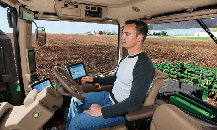
Google and the big automakers might get the lion’s share of attention when it comes to autonomous road vehicles, but John Deere has been making self-driving tractors for more than 15 years.
Among them is the 9RX tractor, which can steer itself, freeing the farmer to focus on business. The 9RX, introduced in August, features an articulated steering system and an optional Active Command Steering (ACS), which improves maneuverability in the field and line-holding ability at transport speeds.
Hands-free driving: Ag companies take the wheel. (Photo: John Deere).
Farmers don’t need to navigate other traffic, just make optimal use of fields. Before farmers began using GPS to plan routes, a few feet would get reworked in every row. With GPS-based auto-driving accurate down to the inch, missed spots and repetition are avoided, saving farmers time, fuel and money.
With a tractor the only moving object in a vast acreage, collisions are highly unlikely. Still, a driver still needs to be at the tractor’s wheel. Unlike consumer vehicles being developed for autonomous operation on public roads, the tractors don’t have external sensors on all sides to prevent collisions. A fully autonomous tractor, which doesn’t require a driver, probably won’t hit the market before 2025, according to John Deere.
Inside the cab, farmers can equip their tractors with a variety of modular systems that allow computers control over operations, starting with a basic satellite guidance system and a touchscreen interface. From there, an add-on lets the tractor make precise turns autonomously, and another uses radio base stations set up around fields to supplement navigational accuracy. Besides the high-tech features, cabs of the 9RX have luxury touches such as an integrated refrigerator and high-quality sound.
Laser Navigation
Other companies that offer auto-steering include Case IH and Autonomous Tractor Corporation.
Case IH offers guidance and steering for use on tractors, such as its Magnum 340 Tractor. (Photo: Case IH)
Case IH provides steering and guidance tools for tractors, combines and sprayers. Its AFS AccuGuide auto guidance enables repeatable accuracy down to sub-inch levels. AFS RowGuide works with AFS AccuGuide to provide accurate, hands-off steering for corn harvests. Two mechanical touch sensors mounted on the corn-head dividers sense row position and provide guidance input in concert with GPS.
Autonomous Tractor bills itself as a non-GPS system without dead spots or signal interference. Instead, it uses a proprietary laser-radio navigation system (LRNS) for sub-inch positioning data, along with its own FieldSmart software that allows farmers to “train” the tractor without programming.
Sonar systems provide full perimeter safety, and pan-tilt cameras communicate via cellular to allow the farmer to monitor progress and remotely resolve issues.
Two flights were conducted at 120 meters and 100 meters to gather data to help the Peruvian government protect the site from erosion and wear from tourism. (Photo: Trimble)
High up in the Peruvian Andes Mountains lies Machu Picchu, an Incan citadel built in the 15th century, now a UNESCO World Heritage Site.
In the fall of 2014, Trimble demonstrated its UX5 Unmanned Aircraft System (UAS) — along with the Trimble Business Center and Inpho UASMaster processing software — at the famed archaeological site.
Machu Picchu is under the threat of landslides and erosion — plus the site experiences heavy rains known to wash away roads. It has also seen an increase in tourism over the years.
As a consequence, the preservation of the landmark is a growing concern for the Peruvian government. Data captured by a fixed-wing UAS is expected to help the many organizations that govern and preserve the site to visualize and monitor the location.
Getting to Machu Picchu is a challenge in itself. A 3.5-hour train ride from the city of Cusco takes visitors almost 8,000 feet above sea level. When a Trimble team visited the site, access to Machu Picchu was arranged well in advance by its distribution partner Geosystems and the Peruvian Ministry of Culture.
Orthophoto of the Macchu Pichu site. (Image: Trimble)
The day of the flight, a small area on one of the terraces was cleared of tourists (but not local llamas) for the flight. Two flights were conducted at 120 meters and 100 meters for enhanced data. Along with Trimble and Geosystems representatives, local archaeologists and surveyors from the Ministry of Culture attended the flight, which went off without any challenges.
With the flight complete, Trimble and Geosystems went to work processing the data immediately in Trimble Business Center and Inpho UASMaster. Trimble Business Center allowed the data to be quickly processed into high-quality point clouds and orthophotos while Inpho UASMaster offers feature-rich photogrammetry workflows.
The following day, Trimble and Geosystems presented government officials with orthophotos and a 3D point cloud model.
Volvo Cars has chosen HERE to power connected navigation for the next-generation in-car control system for new and future Volvo models as part of a multi-year agreement between the two companies.
Volvo’s in-car system, Sensus, offers customers a fully connected experience and incorporates advanced maps and services enabled by the HERE location cloud to provide drivers with smart guidance in and out of the car.
The first model featuring the new Sensus system is the XC90, Volvo’s luxury SUV that started shipping earlier this year.
A huge network of iBeacon (Apple)and Eddystone (Google) devices has emerged in China, consisting of 110,000 units run and managed by Sensoro.
The network spans 25 movie theatres, 16 airports, 39 high-end retail stores, 40 major tourist destinations, 200 universities, 260 high-speed trains, 1,500 Pizza Huts and 2,100 Chow Tai Fook (CTF) jewelry stores, among other locations.
Sensoro was founded in July 2013 through the Microsoft Ventures Accelerator program for startups. Its goal is to construct a data network that integrates intelligent sensors (in this case, Bluetooth) and the mobile Internet.
During the 2015 Chinese New Year in February, traffic at beacon-outfitted locations reached the hundreds of millions, according to a Sensoro blog. CTF’s use of the iBeacons generated 11 million dollars in revenue with a coupon conversion rate as high as 63 percent, far surpassing expectations, according to CTF’s 2015 earnings report. CTF has since deployed beacons in all 2,100 of its mainland China retail stores.
Data gathered by Sensoro will allow retailers to target customers with increasing accuracy the longer the network is in use.
GPS-guided cruise control is now in production for new models of Kenworth long-haul trucks that have the Paccar MX-13 engine.
By anticipating the terrain ahead using GPS, Kenworth Predictive Cruise Control delivers optimal fuel economy by ensuring the engine and transmission are in the most efficient operating mode.
The system is available as a factory-installed option.
In August, U.S. Army Gray Eagle unmanned aircraft took part in manned-unmanned teaming exercises in South Korea, including streaming video and metadata to an AH-64 Apache helicopter while in flight.
Exercise support was conducted from Kunsan Air Base, South Korea, and represent a milestone for the MQ-1C Gray Eagle, proving its ability to conduct operations in diverse weather condition, according to manufacturer General Atomics Aeronautical Systems (GA-ASI).
During the exercise, the Gray Eagle UAS streamed video and metadata via a line-of-sight data link directly to the helicopter from extended distances. The Apache then retransmitted the imagery to a One System Remote Video Terminal (OSRVT), allowing field commanders within the Tactical Operations Center (TOC) to receive both live Gray Eagle streaming video and retransmitted video sent by the Apache. Once the Gray Eagle was airborne, U.S. ground forces passed contact reports and target coordinates to operators in the aircraft’s ground control station. The operators were then able to direct the Gray Eagle’s sensors to positively identify and track the targets.
The Gray Eagle is used by the Army for reconnaissance, surveillance, communications, convoy protection, IED detection and precision weapons delivery.
Scope of Project: The 3D mapping project encompasses all of Singapore — more than 700 square kilometers.
The Singapore Land Authority (SLA) is engaged in a 3D mapping initiative to create and maintain a high-resolution survey-accurate 3D national map. Denmark and Switzerland have national 3D maps, and Hong Kong has mapped its central business district.
3D virtual environments support city planning, decision-making and risk management. SLA’s project involves capturing vast amounts of data and creating 2D and 3D datasets in several formats. The project began in April 2014 with airborne data capture and modeling; the modeling of buildings is expected to be completed this month. Mobile data capturing and road modeling is expected to be completed by the end of 2016.
The 3D models of buildings and road infrastructure are being created from high-quality images and laser-scanning data. The 3D data is stored in the open information model CityGML, which allows for 3D spatial analysis, simulation and visualization.
The project has employed multiple rapid mapping technologies such as oblique imagery, airborne laser scanning, mobile laser scanning and terrestrial scanning, resulting in more than 500 terabytes of data in multiple formats.
Using Bentley Map software, the project team created, maintained and disseminated 3D information directly from the Oracle Spatial database platflorm. In November, Bentley Systems awarded the 3D mapping project the 2015 Be Inspired Award for Innovation in Government.
Building Level of Detail 2: The Singapore project will model up to LOD2.The five levels of detail (LOD) in CityGML are LoD0 (terrain model), LoD1 (block models with no roof structures), LoD2 (explicit roof structures), LoD3 (detailed architectural models) and LoD4 (interior modeling).