Category: Applications

  • Handheld launches its first ultra-rugged Android tablet

    Handheld launches its first ultra-rugged Android tablet

    Handheld Group's new Algiz RT7 tablet is designed for rugged use by mobile workers.
    Handheld Group’s new Algiz RT7 tablet is designed for rugged use by mobile workers.

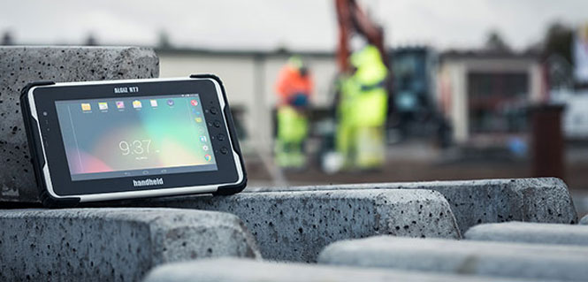
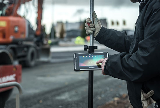
    Handheld Group, a manufacturer of rugged mobile computers, today announced the launch of its new Android tablet, the Algiz RT7. The Algiz RT7 is a powerful, lightweight and ergonomic 7-inch tablet designed for reliable performance in demanding environments.

    The Algiz RT7, which runs Android 5.1.1 (Lollipop), provides a range of features for mobile workforces, Handheld said. It’s fully rugged, meeting stringent MIL-STD-810G U.S. military standards for protection against drops, vibrations and extreme temperatures, and its IP65 rating means that it’s waterproof as well as fully sealed against sand and dust. Weighing just 650 grams, the Algiz RT7 is designed for mobility.

    The Algiz RT7 comes with a built-in accelerometer, gyroscope and e-compass and a stand-alone u-blox EA-7M GPS receiver for navigation, along with built-in Qualcomm IZat location services.

    A Qualcomm MSM8916 (Snapdragon) chipset and 1.2 GHz quad-core processor power the tablet, giving it processing speed, ultra-fast connectivity and long battery life. It comes standard with LTE data and voice capabilities as well as 802.11 b/g/n WLAN, BT Class 1 and Class 2, and NFC functionality. It also has dual cameras (8-megapixel rear-facing and 2-megapixel front-facing), as well as dual SIM-card slots.

    Designed for the mobile worker, the Algiz RT7 sports a high-brightness 7-inch outdoor-viewable capacitive display that can handle true outdoor challenges. Battery performance is key for any mobile application, and the Algiz RT7 comes with a long-life 3.7V 6000mAh lithium-ion battery. Four programmable buttons allow users to launch and use applications in the field. To enhance data capture, users can choose an optional 2D imager or RFID plus 2D imager.

    “Our new Algiz RT7 offers enterprises an exceptional value and is a highly requested product from both our end users and our extensive partner network,” said Jerker Hellström, Handheld Group CEO. “This ultra-rugged tablet delivers best-in-class performance to assist fieldworkers in their daily tasks. The Algiz RT7 is built for tough environments and delivers a streamlined Android experience with power and features appropriate for market demands.”

    The Algiz RT7 can be ordered immediately. Shipping will start in December, with volume deliveries starting January 2016.

  • Project Overlord keeps your wheels safe with GPS

    Project Overlord keeps your wheels safe with GPS

    Photo: Project Overlord

    Project Overlord has launched RimTech in the U.S. Developed by former Nokia, IBM and Motorola executives, RimTech has a built-in GPS, motion sensor and camera, which attach to the tire and act as a security guard for automobile wheels. The vehicle owner controls the device through the accompanying iPhone and Android app, providing total control and surveillance at all times.

    Using a two-stage system to eliminate false alarms to police departments, the vehicle owner is immediately alerted of a security compromise. When the car’s tires are approached closer than 3 inches or moved over 3 mm, RimTech will sound a continuous alarm to deter the thief and alert the owner through a push notification on their phone. If the thief proceeds to remove the wheels from the vehicle, a second mobile alert will notify the owner of the movement while police are simultaneously informed of the property’s location and owner’s vehicle information. The owner can use their mobile RimTech app to track the wheel’s real-time location with an accuracy of less than 10 feet.

    “The auto industry has yet to introduce a fully comprehensive and effective wheel theft prevention system to the marketplace. Wheel locks are totally ineffective and can be removed in seconds. RimTech is the solution,” said Terrence Gaskin, founder and CEO of Project Overlord. “Project Overlord not only wants to protect your vehicle and its wheels, but also intends to partner with insurance companies to offer discounts for protected drivers.”

    According to a recent Yahoo! News article, “Tires and wheels offer a near-perfect combination of attributes to thieves. They’re easy to haul, quick to remove, untraceable on online auction or classified sites, and frequently usable on several different vehicles, with a value that can hit $3,000 and higher per set.”

    Product Highlights

    • App notifies users of tampered or stolen wheels
    • Alarm sounds if parked wheels are approached or move more than 3mm
    • App tracks stolen wheels and notifies authorities
    • Battery lasts a minimum of two days in tracking mode
    • Device captures at least 25 photos of surroundings and thief
  • Bullray UAS designed for defense

    Bullray UAS designed for defense

    Photo: Bullray UAS

    The Bullray UAS is a fully autonomous, amphibious, man-portable tricopter/quadcopter that makes vertical take-offs and landings.

    Rated IP-67, the rugged design is capable of performing in all weather conditions and doesn’t require a transit case. It can carry a significant sensor payload: GPS, FLIR cameras, lidar, metal detection systems and more.

    Rapid Composites ­­— builder of high-end UAVs for the military and first responders — custom manufactures the units. The company won the UAV category in the 2015 JEC Innovation Awards.

  • Canal+ broadcasts race with GPS GeoRacing system

    Canal+ broadcasts race with GPS GeoRacing system

    Photo: Canal+

    Canal+, a French cable television channel, used Trimaran’s GeoRacing GPS tracking and visualization system to improve live television coverage of the Tour de Corse 2015, the FIA World Rally Championship held on the island of Corsica in October.

    Through a combination of GPS data and advanced technologies like virtual timing and ghost visualization, Trimaran’s GeoRacing solution allowed Canal+ to track the motorsport race in real time and better visualize its progression, enhancing the television viewer’s experience. The system dramatically improves the broadcaster’s ability to deliver live audio commentary about the race, giving viewers a race-time comparison of the drivers along with other important stats.

    During the Tour de Corse race, Canal+ used multiple cameras with GPS trackers in cars and helicopters, and at the starting, mid-point and finish lines. The GPS tracking system situated on the cameras was provided by AMPVisual TV, a technology partner of Canal+ and Trimaran.

    Throughout the race, GPS positioning from each of the cars was sent to the GeoRacing system. Using Trimaran’s solution, Canal+ instantly delivered detailed sports information and statistics, such as speed, timing (retiming for staggered starts) and ranking. This enabled viewers to better understand the progression of the live race.

    With the virtual timing capability, Canal+ was able to demonstrate the virtual differences between cars at a precision of 1/10th of a second. Trimaran’s ghost visualization feature provides a 3D representation of the rival positions in real time, creating the feeling that the cars all left the starting line simultaneously.

  • Carlson Mining supports haul trucks


    Carlson Mining 2016 has improvements and added support for AutoCAD 2016 and the new IntelliCAD 8.1. The improvements span the four mining modules: Basic Mining, Geology, Surface Mining, and Underground Mining.

    An upgrade to the Haul Truck Cycle Analysis command now accounts for mixed fleets, delay points and 3D playback of trucks along the haul route.

    In the Underground Mining module, support has been added for multi-level mining with the addition of level labels, allowing the processing of overlapping mine panels with ease.

  • CyberCity 3D interactive maps help cities visualize the future

    A 3D rendering of London. (Image: CyberCity 3D)_
    A 3D rendering of London. (Image: CyberCity 3D)_

    CyberCity 3D has developed a 3D Smart Cities mapping platform to help municipal authorities and planners visualize their towns and cities in 3D. Existing and future city plans, proposed developments and schemes, can all be visualized together with relevant data using a simple, out-of-the-box solution, with streaming to any web connected device.

    The CyberCity 3D Smart City maps can be used for a host of applications including planning, transport, environment and tourism. The models are fully interoperable and will perform on most proprietary software applications such as GIS and 3D design packages and can be streamed via the web. The live streaming uses Cesium open architecture, a cross-platform virtual globe designed for dynamic-data visualization, allowing the 3D models to be viewed on tablets, phones, desktops and laptops.

    CyberCity 3D employs patented 3D modeling process to generate high resolution building models from stereo imagery. The smart buildings automatically contain valuable measurement data, such as height and roof slope, with up to 12.5 cm accuracy. Cities across the world have employed CyberCity 3D technology to support work such as urban planning, economic development, flood risk assessment, transportation planning and line-of-sight studies.

    In the UK, CyberCity 3D has teamed up with aerial mapping company Bluesky, which provides a huge data library covering 150,000 sq km of digital aerial photography, allowing CyberCity 3D to gain access to urban centers across the UK for 3D modeling. CyberCity 3D also has access to Bluesky’s National Tree Map, a digital map detailing more than 300 million trees across the UK, which adds a useful dimension to the 3D Smart City projects, the company said.

    CyberCity 3D has a large smart 3D GIS building library, covering more than 80 cities around the world. Applications include master planning and proposed construction maps, stakeholder, management, engagement and communication, flood analysis visualization, leisure and tourism. CyberCity 3D data is also used in applications such as 3D gaming and augmented reality.

  • Carlson SurveyGNSS 2016 out now

    Carlson SurveyGNSS 2016 out now

    Photo: Carlson SurveyGNSS

    Carlson SurveyGNSS, Carlson Software’s data post-processing software, is now available in a 2016 version.

    Designed for surveyors and positioning professionals, Carlson SurveyGNSS post-processing software achieves high-accuracy results for computing quality vectors and resultant positions. SurveyGNSS works with Carlson SurvCE and SurvPC data collection software, and with Carlson’s office design software.

    New features include a second-generation post-processing engine, which now accepts data in enhanced RINEX 3.x formats. Users will also determine candidate vectors for simultaneous calculation. Previously, vectors were calculated individually.

    Other processes have been sped up or enhanced. With “detached processing,” users will be able to start another task while SurveyGNSS is still working on a computation.

    New constellation and more reference networks are another enhancement. Observations from the Chinese BeiDou and European Union Galileo join GPS and GLONASS, with future constellations in the works.

    For supported “Active” (Online) Reference Networks, the International GNSS Service (IGS) and the governments of Australia, Brazil, Canada, Germany, Spain, European Union, France, Great Britain, Mexico and the Netherlands join the supported networks in addition to the U.S. CORS system.

  • TomTom to provide data for Uber driver app

    TomTom has signed a global, multi-year agreement to provide maps and traffic data for the Uber driver app.

    TomTom’s advanced map-making technology, combined with its traffic information, will ensure Uber has a seamless navigation experience, accurate arrival times and efficient journeys in more than 300 cities around the world, according to a TomTom news release.

    “We are excited to provide Uber with our best-in-class location data,” said Charles Cautley, managing director, Maps and Licensing at TomTom. “TomTom is a truly independent map provider with the platform for the future. With this platform, TomTom is the trusted partner for innovative and future proof location technology for the global automotive and consumer technology industry.”

    “We look forward to working with TomTom, a leader in the mapping and navigation space,” said Matt Wyndowe, head of Product Partnerships at Uber. “Their mapping and traffic data will help ensure we continue to provide a great experience for drivers everywhere.”

  • SP80 under cover in Chile’s rainforests

    In the temperate rainforest of the Los Lagos region of Southern Chile, where rainfall annually exceeds 1,500 millimeters and two-thirds of the days are rainy, the dense forest canopy poses a huge challenge for GNSS receivers.

    Motivazion, a survey firm based in Puerto Montt, just below the rainforests, makes its living surveying in the rugged terrain under the densely canopied forest. Motivazion works primarily for hydropower development companies, surveying contours, cross sections and longitudinal profiles, as well as staking out proposed facilities. To ensure it was using the best GNSS receivers for the conditions, Motivazion conducted field tests of several sets of equipment this summer. 

    Motivazion owner Jorge Mesias said he typically uses a combination of total stations and GNSS receivers for his work. “If understory performance could be improved, efficiency would increase dramatically and reduce the need for using the more time-consuming total station,” Mesias said.

    A light rain fell at all times during the two-day test. The test routine consisted of surveying a total of 21 points in two days. Results were compared to points established by a total station. 

    Base stations were set up in a small area cleared for the purpose, and the rovers moved from point to point under the canopy. Spectra Precision’s SP80 achieved fixed solutions in less than three minutes 95 percent of the time.

    “The SP80 achieved remarkable results,” concluded Mesias. Geocom S.A., Spectra Precision’s dealer in Chile, provided the SP80 and technical support. 

  • Esri story map considers Katrina 10 years later

    Esri story map considers Katrina 10 years later

    Photo: Esri

    In August 2005, Hurricane Katrina struck the city of New Orleans, causing devastating damage and loss of life. A new Esri story map, “Katrina +10: A Decade of Change in New Orleans,” analyzes the damage from the storm.

    “The story map is a new Esri medium for sharing not only data, photos, videos, sounds and maps, but for telling a specific and compelling story by way of that content,” wrote Esri Chief Scientist Dawn Wright in a blog. “This is all done with sophisticated cartographic functionality that does not require advanced training in cartography or GIS.” According to Wright, story maps are applications built from web maps, which in turn are built from web-accessible data.

    The below map shows the physical damage in terms of buildings marked for demolition. In all, 10,317 buildings were tagged for demolition by the city of New Orleans. Following Hurricane Katrina, all properties within the city were reviewed for damage under Section 106 of the National Historic Preservation Act.

    The heat map shows the density of houses deemed eligible for federally funded demolition through the Federal Emergency Management Agency (FEMA). Although not all properties on this map were demolished, the points illustrate Katrina’s extensive and pervasive physical toll on the city of New Orleans.

    For this and other story maps, visit http://storymaps.arcgis.com/.

  • Mapping with Bluetooth

    Mapping with Bluetooth

    BlueStarGPS BlueStarGPS offers both GPS and GNSS options in a rugged, lightweight package. The BlueStarGPS device was designed to meet sub-meter mapping and data collection needs in the pipeline and utility industries. It provides sub-meter precision without post-processing, and maintains accurate positioning when the SBAS signal is obstructed. This means it can function under trees, around buildings and in rugged terrain where other receivers can fail.

    The BlueStarGPS is designed specifically for use with Android mobile devices, such as smartphones, tablets or notebook computers, as well as cable and pipe “locating” tools with a connectivity range of up to 1 kilometer.

  • CHC Navigation launches iOS-ready L1 receiver

    CHC Navigation launches iOS-ready L1 receiver

    The X20i GNSS receiver by CHC Navigation pairs with iOS devices.
    The X20i GNSS receiver by CHC Navigation pairs with iOS devices.

    The X20i L1 GPS receiver by CHC Navigation is powered by a high-precision L1 GPS engine. Its integrated Bluetooth chip enables it to wirelessly collect submeter positions in real­ time or centimeter post-processed on an iPhone or iPad.

    All location-aware apps on the iPhone and iPad are compatible with the X20i. Immediately after pairing and answering the security question allowing the X20i to take control of location services on the iOS device, 1 million iOS applications are capable of utilizing the high-accuracy data of the X20i, and become accurate to either 1 foot or 1 centimeter. Apps that can make use of the high accuracy include TerraGo Edge, ESRI’s ArcView Connector, and those by CarteGraph Systems.