MAPPS has accepted an invitation from the Federal Aviation Administration (FAA) to be a member of the UAS Registration Task Force (RTF) Aviation Rulemaking Committee (ARC).
MAPPS is a national association of private-sector firms in the surveying, spatial data and geographic information systems field in the United States and a leader on the use of unmanned aircraft systems in the geospatial field.
The UAS RTF ARC was announced on Monday by Transportation Secretary Anthony Foxx to help minimize potentially unsafe UAS operations and incidents. The task force will work to develop minimum requirements for a UAS registration process for safe integration of UAS into the National Airspace.
MAPPS has tapped John Perry, founder and CEO of Altavian based in Gainesville, Fla., to represent the association on the task force.
“We are pleased and honored that the FAA has invited MAPPS to participate in the UAS RTF ARC,” said MAPPS President Susan Marlow. “MAPPS has actively called on the FAA to move forward with UAS rulemaking, and we are thrilled to be a part of the process.”
MAPPS has been a voice for the commercial use of UAS for geospatial data acquisition. The association has been engaged with FAA on UAS issues since 2009 and testified before state legislatures and participated in Congressional roundtables. MAPPS Executive Director John Palatiello was appointed to serve on the Federal Aviation Administration (FAA) working group on beyond visual line of sight (BVLOS) operations of commercial unmanned aircraft systems (UAS), and the association serves on a committee of the National Conference of State Legislatures (NCSL) to develop policy recommendations to the 50 state legislatures on UAS.
On Nov. 17-18, MAPPS will host sessions on geospatial activities at Drone World Expo, at the San Jose Convention Center in San Jose, Calif. The geospatial content will explore factors to consider when planning the start-up of a stand-alone UAS business, or a department in an existing surveying or mapping firm. It will kick off with a presentation on “What You Need to Know Before Starting Up Your Unmanned Aircraft System (UAS) Department,” as well as instruction on issues including system operating limitations, flight training, crew responsibilities, operator authority, client expectations, standards and licensing. Speakers at the policy conference will include Bryan Baker, UAS sales manager, Leica Geosystems; Jeff Lovin, senior vice president, director of Geospatial Services, Woolpert; Andy Nickerson of Aerovel Corp.; Mike Tully, president, Aerial Services, Inc.; and David Yoel, CEO, American Aerospace, Inc.
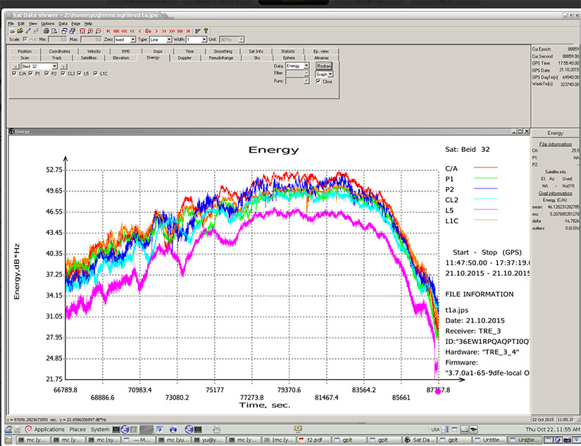
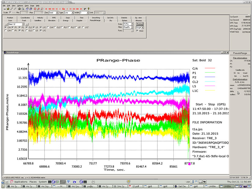
In addition, new signals on 1575.42+1.023*14 MHz (B1-2), 1176.45 MHz (E5A) and 1207.14 (E5B) frequencies for three satellites (PRN 32, 33, 34) also have been decoded and tested.
Here are graphs illustrating the experiment:
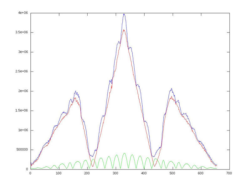
I of BOC(1,1) (red), BOC(6,1) (green) and their sum (blue) vs code shift.
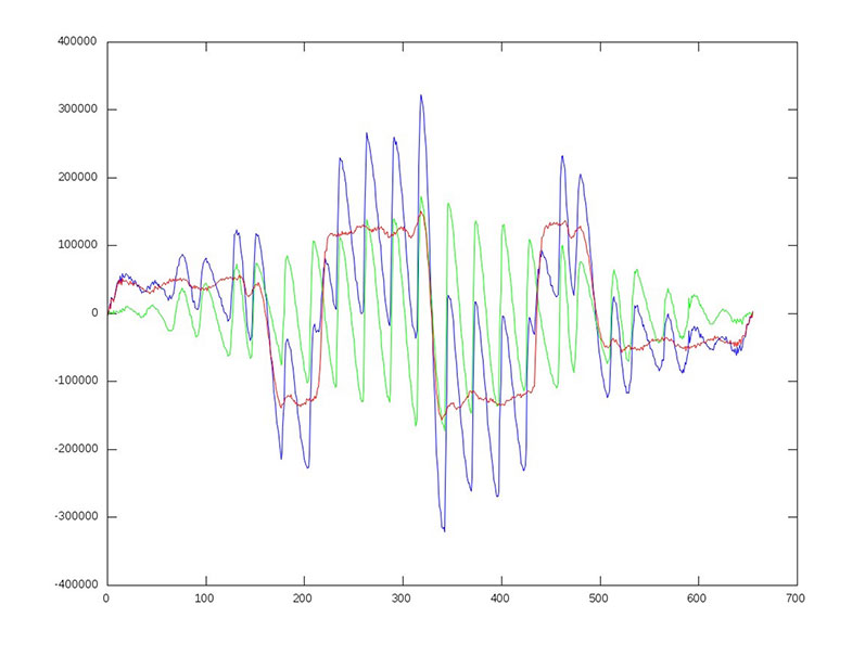
dI of BOC(1,1) (red), BOC(6,1) (green) and their sum (blue) vs code shift.
Horizontal axis: 0 – minus one chip shift; 327 – zero shift; 655 – plus one chip shift
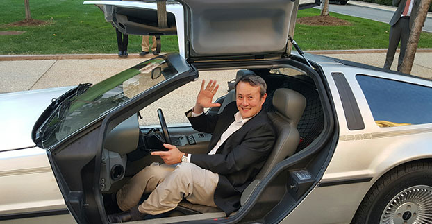
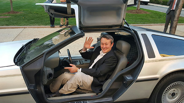
Wireless LBS Contributing Editor Kevin Dennehy sits in Delorean connected vehicle on “Back to the Future Day” Oct. 21 sponsored by ITS America.
The battle over when autonomous vehicles will be on the road for consumers seems to be divided along government/big auto companies/academic institutions vs. such technology companies as Google, Uber, Tesla and others. Two recent Washington events highlighted the gulf in expectations for full autonomous vehicle rollout. The question is, why are the two groups so far apart? Funding? Safety? Cyber Security?
WASHINGTON — A panel of business and auto experts discussed the quick rollout of autonomous vehicles and the implications on business and consumer mobility at an Oct. 14 National Press Club meeting here. In terms of the time for consumer rollout, Google founders Larry Page and Sergey Brin attended a DARPA autonomous vehicle challenge in 2007 and determined they didn’t want to wait 15-20 years to roll out a business, said Larry Burns, Univ. of Michigan professor and Google consultant.
Burns said that when he was the vice president of research and development at GM, it would have been hard to convince company execs and lawyers to go ahead with full-blown autonomous technology, while such technology companies as Google are forging ahead.
Burns acknowledged the technology has to work as the automobile is a complicated and sophisticated machine. “Google has driven over a million miles. They have engineers and technicians capture any real-time incidents and take them back to a lab to create computer programs. I can tell you the technology is very close,” he said. “I think we need to get a small fleet on the road in one place, because the technology has to be proven on real roads, to see what human drivers have to deal with. We have the tendency to rush to large volumes because we think it is the answer, but we need to learn on a small scale — and share the data between regulators and legislators.”
While Burns concentrated on the usual story — autonomous vehicles will dramatically decrease worldwide highway fatalities — he said that a new automotive DNA will shape a new market that will focus on the rise of electric vehicles and a sharing economy. “There will be more shared vehicles and the opportunity to created tailored vehicles. Average speeds are 25 miles per hour and most trips are less than eight miles,” he said. “It will change our dependency on oil, land use, parking and access.”
With automated technologies, a car will be able to decrease in size to 1,000 pounds, which allows an electric car’s battery to work more efficiently, Burns said.
Although they do not have an autonomous vehicle strategy, one Domino’s Pizza executive said that the technology would be important for their own fleets, but the franchisees would have to see a return on investment to purchase their own fleet.
“We own supply chain centers and drive 22 million miles delivering food to thousands of stores,” said Lynn Liddle, Domino’s executive vice president of communications, investor relations and legislative affairs. “The pizza industry has not been on the forefront of transportation. When we were founded, the goal was to get pizza to a dorm in 30 minutes. We are now into tech — quick ordering and texting through Ford Sync. Our Australian franchisees are using GPS-enabled systems that allow [customers] to know when their pizza is coming.”
Burns said he could see a two-person pod swinging by a Domino’s, hitting the post office and Fedex as part of the same trip. “The challenge of bringing goods to my door that weigh less than a pound in the last mile is formidable,” he said. “This is an exciting opportunity for the trucking industry. We may see this Class A trucks shortage of truck drivers [go away]. There is a great early opportunity for goods movement with a very good payback.”
One panel member from Securing America’s Future Energy, or SAFE, said the organization is establishing an Autonomous Vehicle Task Force, a group of industry experts that will assess the social, political, market and regulatory challenges of the new technology.
“It’s important to not be dependent on one fuel source, which is run by very high-priced cartels and national oil companies,” said Robbie Diamond, SAFE president and CEO. “This is the first time we have seen the convergence of technology and business models, not just the safety concerns. This is a once-in-a-century opportunity to have a better mobility system.”
Not Everyone Believes Autonomous Vehicles Will Be Ubiquitous By 2020…
Delorean connected vehicle at “Back to the Future Day” sponsored by ITS America.
Some transportation industry veterans don’t buy that the autonomous vehicle will have a quick rollout. While autonomous vehicles are great for short trips, they may not be the solution for families who live in rural areas, said Thomas Dingus, Virginia Tech Transportation Research Institute, at a Capitol Hill panel sponsored by ITS America Oct. 21.
“The bestselling car today is a pickup. Why would you want an automated vehicle if you live in the country?” Dingus said. “Some [autonomous vehicle] adoption will be at a lower rate, some not at all. We will still have drivers on the road. There is no doubt that automated vehicles are coming, but it will be slower than people think.”
Dingus’ Virginia Tech entity is part of the Virginia Connected Corridor Project, which tested autonomous vehicles on two interstate highways in the Washington, D.C., area recently.
One panel topic is the need for better highway infrastructure in order for automated systems to work. Case in point was the problems Tesla has been having with its new lane-control feature because it cannot read the on-the-road markings. “Automated vehicle technology doesn’t work when you don’t have good lane markings. People who said the technology is ready today are wrong,” said Hillary Cain, Toyota director of technology and innovation policy. “We really need to make better investment in our infrastructure.”
Cain also said that the industry is far away from achieving National Highway Safety Testing Administration Level 4, or full self-driving automation. “We are much farther away than we think we are,” she said.
Despite a nationwide shortage of drivers, one trucking industry executive on the panel didn’t seem sold on autonomous vehicles. “The [automated] solution has to be 99.9 percent safe. You have to prove you could have done better than with a human being driving,” said Alan Korn, Meritor WABCO director of advanced brake systems integration.
Also at the panel, Sen. Gary Peters, D-Mich., gave his opinions of the Google car and the new Michigan Mobility Transformation Center, and said the new autonomous technologies will be disruptive to whole industries. “The number-one job at risk is drivers. But the most dangerous vehicle on the highway will be driven by humans,” he said. “I had the opportunity to ride in the Google car, it’s a bit freaky.”
In other news:
Driverless, the Business of Autonomous Vehicles, will be held March 22-23, 2016, at the Crowne Plaza Hotel-San Francisco Airport. More than 30 speakers will discuss worldwide autonomous vehicle markets, safety and security, new technologies and other topics. Go to www.driverlessmarket.com for more information.
We fear the hacker who might corrupt the software system of our vehicles. Maybe they will subvert our brakes or steering. And Volkswagen gave us a new scare. Maybe we should fear the car manufacturer. Can we trust vehicle OEMs for the safety of self-driving cars? Before we buy a vehicle, most of us read reviews and test drive the vehicle. In a short drive, we can judge the peppiness of the engine and handling around corners. We can’t test the reliability of the vehicle software, a particular concern when it is going to be driving our car.
Tesla just released Autopilot, a $2,500 optional software upgrade which, in a blink, enables autonomous driving. Model S owners wirelessly download the software, and voila, have a self-driving vehicle.
This isn’t the first semi-autonomous vehicle. Volvo and Mercedes-Benz have these features, but at lower speeds or with the requirement that the driver touch the steering wheel at prescribed intervals. Toyota is playing catch-up, and announced a target to commercialize semi-autonomous cars in five years. Later this year, Toyota plans to launch three new car models in Japan with sensor technology and vehicle-to-vehicle and vehicle-to-infrastructure communication.
Tesla has been out in front of these efforts in speed and hands-off control with Autopilot able to drive at 70 miles per hour. A driver must have faith in an automaker’s testing, quality control and honesty to put himself in the hands of new software for such a ride. Aaron M. Kessler of the New York Times recently drove a Tesla with Autopilot. Within 20 minutes, he felt comfortable enough to withdraw his hand from near the steering wheel to his lap. He was confident in what he observed in those 20 minutes. Smart? I’m not convinced.
With Consumer Reportsdropping its recommendation of the Model S, Tesla is faced with public outing of problems that plague any new car model. In a survey of 1,400 survey Model S owners, Consumer Reports discovered noise, motors and door issues with the car. Shares of Tesla fell 10 percent with news of the pulled recommendation, and perhaps will lower confidence in the reliability of Autopilot.
Road & Track magazine recently sounded off to their readers that despite concerns that driving will no longer be fun, autonomous vehicles will arrive, wanted or not. Readers were warned of a future where self-driving would be allowed only on designated roads and would entail a higher insurance premium. The bet is that software from companies (VW?) will be more dependable than we humans.
In October 2014, Tesla started equipping its Model S with hardware to allow for the incremental introduction of self-driving technology: a forward radar, a forward-looking camera, 12 long-range ultrasonic sensors positioned to sense 16 feet around the car in every direction at all speeds, and a high-precision digitally controlled electric assist braking system.
Version 7.0 of Tesla’s software has now been released with Autopilot, which allows those tools to deliver a range of new features designed to work in conjunction with the automated driving capabilities already offered in Model S.
Tesla calls Autopilot a major step toward autonomous driving. “Tesla Autopilot relieves drivers of the most tedious and potentially dangerous aspects of road travel,” according to a Tesla blog. “While truly driverless cars are still a few years away, Tesla Autopilot functions like the systems that airplane pilots use when conditions are clear. The driver is still responsible for, and ultimately in control of, the car. What’s more, you always have intuitive access to the information your car is using to inform its actions.”
The combined suite of features represents an integrated autopilot system involving four different feedback modules: camera, radar, ultrasonics and GPS. “These mutually reinforcing systems offer real-time data feedback from the Tesla fleet, ensuring that the system is continually learning and improving upon itself,” the Tesla blog said.
Autopilot allows Model S to steer within a lane, change lanes with the tap of a turn signal, and manage speed by using active, traffic-aware cruise control. Digital control of motors, brakes and steering helps avoid collisions from the front and sides, as well as prevent the car from wandering off the road. “Your car can also scan for a parking space, alert you when one is available, and parallel park on command,” Tesla said.
Release of version 7.0 also features a significant visual refresh of the digital display. The instrument panel is focused on the driver and includes more functional apps to help monitor the ride.
Tesla founder Elon Musk said during a press conference that drivers should exercise caution in the initial months of the rollout, and consider Version 7.0 a beta release. “We’re advising drivers to keep their hands on the wheel at this early stage,” Musk said. The car’s dash alerts drivers when they need to take the wheel.
Just days after the launch, videos began appearing on the Internet showing near misses and other errors.
The 2015 edition of the European Satellite Navigation Competition GSA Special Prize was awarded to Rafael Olmedo for the KYNEO project. The project develops inexpensive, flexible Galileo and EGNOS enabled modules that allow ubiquitous positioning data for applications in the Internet of Things. Other winners of the competition are listed here.
Described as an open innovation platform for the GNSS of Things, the basis of the KYNEO concept is a perceived need to be able to fast prototype applications and devices in the rapidly developing field of the Internet of Things. According to Olmedo, a variety of Internet of Things platforms are looking for positioning systems that can be flexible and adapted to a variety of situations and circumstances. To serve this objective, the product works as an open-source software for the creation of interactive electronic objects.
REMINDER: For continued undisturbed use of GPS as Internet use mushrooms, led by the booming Internet of Things, more efficient utilization of spectrum bandwidth on all sides is essential; for this, synchronization is key. Timing experts will share their views during GPS World‘s “Timing, Time Transfer and Synchronization: New Applications and Techniques” webinar sponsored by EndRun Technologies on Thursday, Oct. 29. Registration is free.
“There is a huge development community for digital electronic products out there, and our aim with KYNEO is to provide a great positioning tool for this community,” Olmedo said. “The first KYNEO products are already available to order via our website, but we will also sell via the many open hardware platforms that already serve the developer community.”
“The Internet of Things is a potentially massive global market for European GNSS programs, offering many benefits to the end users,” said GSA Executive Director Carlo des Dorides. “Open source programmes like the KYNEO project will not only prove to be competitive in their own right, but will also open doors to related services and other opportunities.”
The project was selected from a record-breaking 192 entries. Entries came from 29 different countries, with 72 entries coming from individuals and 59 from start-up companies. The award was announced during a special awards ceremony, held on the opening day of the Satellite Masters Conference in Berlin.
About the European Satellite Navigation Competition
Since 2004, the European Satellite Navigation Competition (ESNC) has been rewarding the best services, products, and business cases that utilize satellite navigation in everyday life. Over this time, ESNC has evolved into an international innovation competition — one that recognizes the best ideas in the field of satellite navigation. Entries come from a wide range of companies, research institutes, students and individuals.
“The GSA Special Prize nicely complements the Agency’s focus — getting closer to the end user and helping them benefit from European space technology,” des Dorides said. “Whether through competitions like this, or through such funding programmes and Horizon 2020 and Fundamental Elements, it’s by supporting innovative applications like KYNEO that the GSA will be able to succeed at its mission.”
Each year, the GSA Special Topic Prize awards the most promising European GNSS application idea. The winner of the GSA prize has the opportunity to realise his or her idea at a suitable EU incubation centre for six months, with the option of an additional six months based on evaluation after the first period. The award criteria is based on the uniqueness and originality of the idea, its business (and social) potential, the credibility of the corresponding team, and the application’s use of unique EGNOS/Galileo features.
PCTEL Inc. has launched a new GNSS multi-satellite antenna portfolio for mobile and base-station timing applications. PCTEL’s new SkyLink antenna technology features out-of-band rejection characteristics that provide exceptional GPS/Galileo and GLONASS L1 support and performance in heavy RF traffic environments for fixed and mobile timing and asset tracking applications.
The new portfolio consists of two product lines:
SkyCompass for fleet management and asset tracking applications
SkyStamp base-station antennas for timing and synchronization of 4G LTE cellular networks.
SkyCompass comprises six new configurable antenna platforms, including single-band or multiband GNSS options that address the majority of fleet management installation needs. SkyStamp offers two timing reference and synchronization antenna models that provide maximum mitigation of the effects from nearby LTE interference sources.
“Over the last decade, PCTEL has been the industry’s technology leader in high rejection GPS products. These antennas are deployed worldwide by OEM customers in aviation, defense, and fleet management public safety projects,” said Rishi Bharadwaj, vice president and general manager of PCTEL’s Connected Solutions. “True to our commitment to support global communications and evolving requirements, PCTEL’s SkyLink technology provides global multi-satellite GNSS coverage and precision tracking by rejecting RF noise or interference that can negatively affect communications in performance critical situations.”
SkyCompass and SkyStamp antennas will be available for shipment in November.
Telit’s cellular and GNSS Internet of Things (IoT) modules will integrate Yon Motor, a new product from Nastek Indústria e Tecnologia, bringing to market a tiny vehicle tracker with a user-friendly mobile app. Besides vehicle security, speed is a top concerns for parents of teenage drivers. Yon Motor targets this market, delivering real-time location and speed data to a smartphone app along with a number of vehicle security features.
The innovative project was developed in partnership with Telit. The company’s GL865-QUAD and SL871 GPS modules are integrated in the miniature Yon Motor to deliver machine-to-machine communication and location awareness respectively. The free Yon Motor mobile app is available for download in iOS and Android.
“What parent would not want to know about their children’s night out or would not sleep better knowing that they are respecting speed limits? The idea of Yon Motor was to create something that could get people closer through Internet of Things,” says Lauro Cruz, CTO, Nastek. The Yon Motor tracker was built with latest generation technology. Moreover, the solution is lightweight and waterproof, permitting parents to secure it to any motor vehicle.
“The Yon mobile app lets users follow vehicle movements in real time and can be downloaded for free to a smartphone. The tracker helps combat car accidents involving young people, since parents have full visibility of their children’s driving speeds and the routes they take,” Cruz said.
SmartDrive Systems has introduced the SmartDrive SmartChoice Program, a video-based safety program that provides fleets the freedom to choose the level of video protection that best aligns with their specific business priorities and needs.
Whether the company’s primary objective is exonerating drivers from frivolous claims or preventing collisions with 360-degree visibility to risk, SmartDrive’s SmartChoice Program offers a product line to meet each fleet’s requirements. The new SmartDrive Shield and SmartDrive Defender, in conjunction with SmartDrive Assurance, offer flexibility in video-based safety by providing a program allowing users to start now and upgrade at any time with existing hardware.
“With our SmartDrive SmartChoice Program, we put choice squarely in the hands of our customers, ensuring every fleet now has a better way to protect its drivers with video,” said Steve Mitgang, CEO of SmartDrive, “We understand that a video safety program needs to fit the culture of the individual fleet. With three video-safety product lines and our distinctive open platform, SmartDrive’s SmartChoice Program lets fleets decide what they need, how best to deploy video within their operation and when the time is right to scale their investment, by moving up to a more comprehensive solution as their requirements expand.”
With the SmartDrive SmartChoice program, fleets can choose from among three product lines, each with unique capabilities and benefits, as described below:
SmartDrive Shield — A road-facing camera combined with on-demand video offload and easy-to-use review workflow, SmartDrive Shield is designed for fleets that have owner operators or are not yet ready for integrated coaching, and are focused on capturing every collision, exonerating when not at fault and providing drivers the ability to record issues on the road, such as delivery verification and security incidents.
SmartDrive Defender — Configurations of up to two cameras offer road-facing and cab views, with automatic video offload, risk scoring and integrated coaching. SmartDrive Defender is designed for fleets that want to protect every driver by identifying high-risk incidents — including speeding, lane departure, hard braking and collisions — and provide proactive coaching to reduce collision frequency, improve safety and reinforce good driving skills.
SmartDrive Assurance — Deployment of up to four cameras enables a 360-degree view of the vehicle and insight into the most frequent causes of collisions — such as U-turns, backing, unintended lane changes, roll-overs and close following — delivering a high level of coverage and complete visibility to risk. SmartDrive Assurance is designed for fleets focused on maximum protection and prevention of safety and compliance-related incidents.
The SmartDrive multi-tiered video-based safety program identifies unsafe driving with an extensible platform, integrating video, vehicle data, audio and driving data for a unified and comprehensive view of risk. The SmartDrive SmartChoice Program offers unmatched flexibility for fleets with a wide range of priorities, while ensuring that companies’ investments in video solutions are protected and can evolve as their operational needs change and technology advances.
Fleets that previously felt video safety didn’t fit their driver or operational environment now have an option with SmartDrive Shield, a no-coaching, road-facing only solution focused on exonerating drivers in not-at-fault collisions. When ready for an integrated safety program, fleets can easily move to SmartDrive Defender or SmartDrive Assurance, leveraging the same flexible video analytics platform.
“With our SmartChoice Program, it’s all about letting fleets decide what’s best for them, in terms of onboard system integration, how many cameras they incorporate, what type of risk they want to measure, and how or if coaching is part of their operations,” emphasized Mitgang. “SmartDrive Shield, Defender and Assurance not only reduce collisions, but also save fleets time and resources, which can then be focused on delivering increased value to their customers through on-time delivery, accuracy and better overall service.”
Omnitracs LLC has added Omnitracs Navigation to its portfolio of solutions. Omnitracs Navigation uses Big Data collected from more than 250,000 customers contributing more than four billion data points. The company terms Omnitracs Navigation the “next generation of navigation solutions” — it provides critical information to drivers through a user-friendly interface, with fast, near real-time updates and extensive fleet configuration options.
Omnitracs Navigation delivers critical information drivers need in a meaningful and distraction-free way, enabling them to be time efficient, stress free and safe while navigating.
Omnitracs Navigation provides fleets and drivers with the following features:
Data Publishing — All of the data is stored onboard with Omnitracs as the data publisher. Updates are sent to the unit automatically as the data changes so that the unit is always current. By leveraging traditional data (such as posted speed and traffic light locations) combined with real-time data (including current traffic and weather conditions), and Big Data (how a particular road is used at a certain time, and “black spot” high frequency accident zones), Omnitracs Navigation delivers a more consistent, predictable and accurate plan for maximizing the road network.
Actionable Data — Data is pulled from Omnitracs telematics units to build statistical models that create an enhanced, truck-preferred network that is constantly pushing new and actionable data to drivers. More than turn-by-turn instructions, the tool is constantly updated to ensure that drivers have a better and safer navigation experience.
Driver Community — Omnitracs Navigation has a closed-loop feedback mechanism, which brings driver feedback into the data-editing process and gives them an opportunity to improve their navigation experience, along with the navigation experience of fellow drivers. The loop is closed by informing the driver of how his or her feedback was used, leading to improved driver satisfaction and retention by acting as the driver’s trusted advisor.
“Navigation has evolved with the advent of smartphones and GPS devices, and the days of folded paper road maps are gone,” said Rick Turek, chief navigation scientist at Omnitracs. “However, we know that current and hybrid systems aren’t yet perfected and still struggle in keeping data current. Imagine not knowing that a new road has opened up or that a road’s name has changed; these are the types of things that can easily frustrate drivers. Omnitracs Navigation is the next-generation navigational solution that delivers current and actionable data so that drivers can do their jobs more safely and efficiently.”
Omnitracs Navigation leverages the proven technologies of HERE and INRIX. HERE Map Content contributes rich, automotive-grade data that enables large semi fleets to navigate across the U.S. and Canada. Through this partnership, Omnitracs provides precise turn-by-turn navigation, as well as enhanced resource tracking and route optimization.
INRIX will provide real-time traffic and historic traffic profiles, along with travel time and incident alerts, for every major road type including highways, arterials and city streets. INRIX combines information from connected vehicles and other public and private sources to provide accurate real-time traffic that covers more than five million miles in 42 countries. Omnitracs Navigation will launch with INRIX Traffic XD Profiles, followed by real-time traffic and incidents.
Trimble has launched Trimble Asset Tracking, a solution that offers complete visibility into the location and utilization of portable assets from a convenient portal.
An enhancement to its fleet management portfolio, Trimble Asset Tracking enables field service organizations operating high-value portable assets, such as generators, pumps or trailers that are towed behind a service vehicle, to better manage asset performance and costs to increase efficiencies and improve operations.
“We recognize the importance for businesses to have the visibility to not only manage their vehicles but also their portable assets,” said John Cameron, general manager of Trimble’s Field Service Management Division. “Asset tracking solutions are becoming an increasingly valuable tool for those that rent, lease or own portable assets that are critical to their field service operation. Having real-time information into the location and utilization of portable assets can enable businesses to determine how best they should be deployed in order to optimize productivity and their return-on-investment.”
Key features include:
A map view of the location and status of the towed, powered and non-powered assets.
Integration with Trimble Fleet Management to view vehicles alongside the assets within one interface.
High-level utilization reports for an individual or group of assets from across multiple locations.
Rugged hardware with simple installation.
Long-life battery that can send location alerts for up to 3 months on a single charge.
Real-time alerts if a unit changes location, has been disconnected and wakes on motion for instant location reporting.
Trimble Asset Tracking enables businesses in industries from construction to utilities to streamline their workflow in the field. When deployed in conjunction with Trimble Fleet Management, businesses can benefit from a single portal to view their entire field operation, knowing where each vehicle and asset is in real time at the touch of a button.
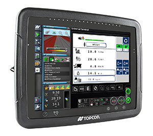
Topcon Precision Agriculture has expanded its precision agriculture line of solutions to include a new yield monitoring system — YieldTrakk.
YieldTrakk is an optical sensing, volumetric solution designed to provide operators with the real-time data collection needed to make intelligent business decisions in the combine cab and afterward. It includes monitoring and mapping of yield (in bushels or tonnes), moisture and cut rate, as well as the total weight of crop during harvest.
“YieldTrakk provides an excellent solution for data collection, mapping and analysis that ultimately allows operators to reduce input costs and operate more efficiently,” said Brian Sorbe, Topcon Precision Agriculture director of sales, Americas. “The addition of yield monitoring expands the scope of Topcon precision agriculture solutions to meet the full-season productivity demands of modern farming.”
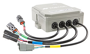
YieldTrakk works by using non-contact optical sensors installed in the clean grain elevator to calculate accurate live yield data. The ECU (electronic control unit) converts the measurement into a weight for the crop harvested. When the crop travels up to the bubble up auger, a second set of sensors measure crop moisture level and incorporates that into the data along with the yield output. To help optimize accuracy, the ECU also measures slope variations and corrects the signal for any fluctuation in machine angle.
The system is a universal solution designed to fit nearly every brand of combine on today’s market. It includes retrofit solutions for most combines, a plug-and-play application for CLAAS combines, and a connection using ISO in AGCO Fieldstar II-ready combines.
The new yield monitor system is integrated with the Topcon Horizon software on the Topcon X30 touchscreen console — displaying the yield and moisture levels in separate sets of data to provide the operator a more complete understanding of field and crop conditions.
YieldTrakk is compatible with most software packages in the industry for further analysis by utilizing industry standard ISOXML and shape file format for data export instead of the proprietary data formats used by most competitors. This information can be used to trace inputs and outputs by precise location and ultimately allows the user to vary seed, fertilizer, chemical or other inputs as-applied.
“This is a great example of how we’re able to leverage synergies with our recent acquisition of Wachnendorff Elektronik, Digi-Star, RDS Technologies and NORAC to further provide combine owners and our OEMs with the high accuracy precision tools they need,” said Michael Gomes, Topcon Precision Agriculture vice president of business development.