INRIX, a provider of traffic information and driver services, has introduced a new app for the iPhone and iPad that helps drivers take control of their commute and avoid traffic. The company said that INRIX Traffic helps cut the cost of gridlock with the following features:
Fastest Routes to Home and Work: Drivers can easily decide which route is the best choice to get around traffic, as the app analyses the effect accidents, sporting events, concerts, and other events have on traffic to deliver the fastest routes with the least delay.
Recommended Departure and Travel Times: The INRIX Traffic Forecast Slider shows drivers the best options for avoiding frustrating delays now and in the future.
Share INRIX Arrival Times: Users can send their INRIX Arrival Time instantly to any contact with just a few taps.
Personalized Traffic Alerts: Drivers can tune their app to alert them to accidents and other incidents causing delays along their route.
“We’re putting 100 million traffic reporters into the palm of your hand,” said Kevin Foreman, INRIX vice president of Consumer Applications. “Our latest release helps drivers never be late again.”
The new INRIX Traffic App is available as a free, ad-free download for iPhone; iPad and iPod Touch from the Apple App Store.
Polaris Wireless, maker of high-accuracy, software-based wireless location solutions, today announced a significant customer contract for a multi-million dollar deployment of the Polaris Wireless Altus and OmniLocate location surveillance product suite in the Europe-Middle East-Africa (EMEA) region. Polaris Wireless said it could not disclose the customer’s name at this time.
The deal represents a major increase in Polaris Wireless business, and is the 14th deployment of the Polaris Wireless high-accuracy wireless location surveillance solution outside the U.S. and 38th globally. Polaris Wireless high-accuracy location solutions are a tool used to combat crime and terrorism, and have been extensively deployed since 2003 for public safety applications in the U.S. market.
“We are very pleased to have achieved such a significant company milestone for high-accuracy wireless location surveillance solutions,” said Manlio Allegra, Polaris Wireless CEO and co-founder. “Our momentum is directly attributed to our unmatched ability to consistently deliver a 2G/3G-compatible (and very soon 4G) high-accuracy, highly-scalable, software-based location solution for public safety and surveillance.”
The Polaris Wireless Altus application suite is a software-based surveillance solution that enables accurate mass location — providing users the ability to simultaneously locate all subscribers in a wireless network in real time and on a historical basis. This unique capability enables functions, such as target identification, tracking via geo-fence, and post-event analytics, which are vital to the anti-crime and anti-terrorism surveillance efforts of Polaris Wireless customers around the world, the company said.
“This deal has contributed to the highest revenue-earning year in Polaris Wireless history,” continued Allegra. “We are exploring several additional opportunities in the international marketplace, and plan to increase our workforce in order to meet the growing demand.”
To maximize its accuracy location performance, the Altus application suite is being deployed with the OmniLocate platform powered by Polaris Wireless Location Signatures (WLS), a software-based location method for dense urban and indoor environments. Polaris WLS is capable of locating a wireless device to within 40 meters for the majority of the calls and helps customers avoid the costly and time-consuming deployment and maintenance associated with hardware-based location solutions, the company said.
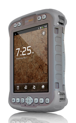
Juniper Systems announced the Mesa Rugged Notepad with Android (AOSP) 2.3 operating system. In a partnership with Pennsylvania-based SDG Systems, the RAMPAGE 6 will be distributed exclusively through SDG Systems.
“Our new partnership with SDG Systems will further enhance our ability to provide the best rugged handheld computing solutions to our customers. By working together, we have created a very unique and in-demand handheld computer with the Android (AOSP) operating system, now known as the RAMPAGE 6,” said Rob Campbell, President and CEO of Juniper Systems. “Leveraging the Android expertise of SDG gives our customers an original and powerful data collection device and we couldn’t be more excited about the opportunities this new partnership will bring.”
According to the announcement, the Android (AOSP) 2.3 operating system on the RAMPAGE 6 offers many advantages for data collection, including easy multi-tasking, a modern user interface, rich programming environment, multi-platform development, abundant application data storage, open source flexibility, and the opportunity for a custom Android interface developed by SDG Systems. Additionally, its optional kiosk mode allows only certain applications to be accessible by the user, successfully creating a single-purpose device without distractions.
“SDG Systems is proud to develop and distribute the RAMPAGE 6 as our very first SDG-branded handheld computer. Collaborating with Juniper Systems on a product as unique and dependable as the Mesa Rugged Notepad has made this experience very rewarding and we’re excited to put the SDG name on it. Our decision to develop Android (AOSP) for the Mesa was based on its extreme ruggedness, quality design, and dependability. I am confident that the RAMPAGE 6 will live up to those standards,” said Todd Blumer, President and CEO of SDG Systems.
Juniper reports that the RAMPAGE 6 will feature the many advantages and benefits of the Mesa Rugged Notepad, including a large 5.7 inch viewing display, IP67 ingress protection rating for water and dust, integrated 2–5 meter GPS receiver, optional integration of a 1D/2D barcode scanner, and optional Class I, Division 2 certification for use in hazardous locations.
Availability of the RAMPAGE 6 is scheduled for the third quarter of 2012 and its first public presentation will be at the Esri International User Conference in San Diego, July 23–27, 2012.
Some years ago, I predicted that the price of GIS data-collection hardware would eventually decline to the point that software would be the most expensive part of a GIS data-collection system. Well, I’m beginning to rethink that statement. Here’s why.
There’s a solid push towards the open source concept in GIS. Since 2006, there’s been an annual conference called FOSS4G (Free and Open Source Software for Geospatial) hosted by OSGeo, the Open Source Geospatial Foundation. According to the OSGeo website,
The Open Source Geospatial Foundation, or OSGeo, is a not-for-profit organization whose mission is to support the collaborative development of open source geospatial software, and promote its widespread use. The foundation provides financial, organizational and legal support to the broader open source geospatial community. It also serves as an independent legal entity to which community members can contribute code, funding and other resources, secure in the knowledge that their contributions will be maintained for public benefit. OSGeo also serves as an outreach and advocacy organization for the open source geospatial community, and provides a common forum and shared infrastructure for improving cross-project collaboration.
The foundation’s projects are all freely available and useable under an OSI-certified open source license.
The OSGeo Mission Statement:
To support the collaborative development of open source geospatial software, and promote its widespread use.
OSGeo Goals:
The following more detailed goals support the overall mission:
To provide resources for foundation projects — e.g., infrastructure, funding, legal.
To promote freely available geodata — free software is useless without data.
To promote the use of open source software in the geospatial industry (not just foundation software) — e.g., PR, training, outreach.
To encourage the implementation of open standards and standards-based interoperability in foundation projects.
To ensure a high degree of quality in foundation projects in order to build and preserve the foundation “brand”.
To make foundation and related software more accessible to end users — e.g., binary “stack” builds, cross package documentation.
To provide support for the use of OSGeo software in education via curriculum development, outreach, and support.
To encourage communication and cooperation between OSGeo communities on different language (eg. Java/C/Python) and operating system (eg. Win32, Unix, MacOS) platforms.
To support use and contribution to foundation projects from the worldwide community through internationalization of software and community outreach.
To operate an annual OSGeo Conference, possibly in cooperation with related efforts (e.g., EOGEO).
To award the Sol Katz award for service to the OSGeo community.
Clearly, from the mission statement and goals, this effort is all about the geospatial user community, and you should stay tuned into this effort.
Some of the current OSGeo projects include desktop GIS applications like gvSIG, Quantum GIS, and GRASS GIS.
gvSIG Desktop App.
There is also a gvSIG Mobile app I mentioned in last week’s Geospatial Solutions Weekly column. It was developed using Java and runs on the Windows Mobile platform. With both gvSIG desktop and mobile, you can have an entire GIS data collection and desktop software suite free of charge. Of course, free comes with a price. There’s no accountability, no priority tech support, no one to call when you can’t figure out why things aren’t working, etc. You’re on your own, sort of. There’s an online community of users who interact and support each other. Also, like open source operating system LINUX, there are companies that will provide commercial support for open source GIS apps.
gvSIG originated in Spain, and although it is available in more than 20 languages, it hasn’t gained much momentum in the U.S. yet. I think it’s an important enough subject that I’ve added it as a session topic to the Field Technology Conference this September. We will have at least one technical presentation on the subject and I will address open source GIS in my keynote presentation. If we’re lucky, we’ll also have a hands-on open source GIS area so conference attendees can see open source GIS apps being used in action.
Free and open source software will continue to grow as viable alternatives both in terms of software, and potentially in analysis and processing.
Free and open access to data will become the norm and geospatial information will increasingly be seen as an essential public good.
Within five years the level of detail on transport systems within OpenStreetMap will exceed virtually all other data sources and will be respected and used by major organisations and governments across the globe.
National Mapping Agencies are likely to find it difficult to justify the costs of traditional data maintenance mechanisms as their products are used in increasingly niche areas.
Crowdsourced content will decrease cost, improve accuracy and increase availability of rich geospatial information.
There will be increased combining of imagery with crowdsourced data to create datasets that could not have been created affordably on their own.
Crowdsourced data will push National Mapping Agencies towards niche markets.
Progress will be made on bridging the gap between authoritative data and crowdsourced data, moving towards true collaboration.
Crowdsourced sensoring will emerge.
There is unlikely to be a market for datasets like those currently sold to power navigation and location-based services solutions in 5 years, as they will have been superseded by crowdsourced datasets from OpenStreetMaps or other comparable initiatives.
It’s going to be very interesting to watch how quickly open source GIS apps and data (e.g., OpenStreetMap) are adopted. Part of the challenge is market awareness of open source GIS apps and data. Being open source (free), there aren’t big (or any) marketing budgets to promote the open source GIS concepts and products. Another challenge is if one chooses to implement open source GIS apps, there’s limited amount of technical support available to implement and maintain the apps unless there’s a reasonable level of commercial technical support available. However, as the adoption of open source GIS increases, it’s reasonable to assume the quality and quantity of user community technical support will grow.
If any of my readers use open source GIS apps and would like to share, I’d love to hear about your experiences. Click here to send me a quick email.
Blue Marble Geographics announced the release of Global Mapper version 13.2. This release features updated DigitalGlobe premium imagery with improved access to new DigitalGlobe servers.
According to the announcement, Global Mapper 13.2 includes updates to the DigitalGlobe premium imagery in both speed and coverage. This service will give users faster access to more up-to-date and higher resolution imagery in most locations. Using the Download Online imagery/Data menu, we have added built-in access to Geologic Map datasets for most of the world. This release also features access to Intermap NextMap web store 2.0 for rich, high precision elevation and expanded coverage data sets. Additionally, added to the imagery service is MapQuest OpenAerial Worldwide Imagery, now a built in source. There is also added support for specifying custom paper sizes for geospatial PDF support in version 13.2. This minor version release includes new format support for LogASCII, Norwegian SOSI export, PCI Geomatix PIX, NDVI in HDF5 format, EasyGPS .loc, and several other formats. There are noteworthy enhancements to the Digitizer tool as well as many other minor enhancements and updates throughout the software.
“Global Mapper’s access to quality data sets is an important part of the power of this leading data conversion services,” stated Blue Marble’s President Patrick Cunningham. “We are pleased to work closely with data providers like Digital Globe, Intermap, and Spatial Energy to offer a premium variety of data sources that enhances our vast complementary data sources for our customers work.”
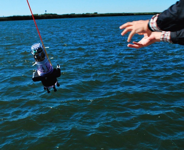
UC Berkeley researchers have developed a method to learn about the quality, volume, speed, and direction of the flow of salt walter and freshwater through the Sacramento Delta. (Photo courtesy of : University of California, Berkeley.)
Swarms of robots equipped with GPS and sensors were released May 9 into California rivers to measure water flow, salinty levels, and pollution, reports OurAmazingPlanet.com. The Floating Sensor Network is intended to change the way water quality and flows are monitored in the Sacramento-San Joaquin river system.
At the University of California, Berkeley, a group of 100 robots was released into the Sacramento River near Walnut Grove. About two thirds of California’s fresh water is in the river system, supplying about two-thirds of the state’s population with drinking water and irrigation. The initiative is led by associate professor Alexandre Bayen at the Center for Informatin Technology Research in the Interest of Society (CITRIS).
The robots each have a sensor to test salinity and a GPS unit from a smartphone. Some have propellers so they can maneuver around obstacles and reach specific destinations. The robots are also sending Tweets, to @fsnandroid61.
Watch Electrical Engineering Graduate Student, Andrew Tinka, describe the project:
Trimble has introduced the Aardvark DR+GPS module that combines dead reckoning (DR) with GPS technology on a single, compact board. The Trimble Aardvark DR+GPS module provides positioning information when GPS signals are limited or not available, such as in urban canyons and tunnels. The Aardvark DR+GPS module is being marketed as a solution for system integrators or OEMs who are adding dead reckoning capabilities to vehicle navigation, fleet management and asset tracking systems.
Dead reckoning estimates position based on heading and distance traveled since the last known position. The more accurate the speed, time and heading inputs, the more accurate the dead reckoning. GPS contributes to accuracy by continuously calibrating the gyro and speed sensors to produce optimal dead reckoning.
The 19 x 19 millimeter surface-mount module has an on-board gyro and collects speed and forward/reverse data from the vehicle’s sensors. Its DR+GPS algorithm automatically calibrates the gyro and external sensors’ inputs and blends this information with GPS measurements to produce accurate position and velocity outputs in hostile GPS environments such as urban canyons.
The Aardvark DR+GPS module is available in two configurations: model number 88788-30 for flat installations; and model number 88788-50 with a feature supporting variable mounting installations. The 88788-50 self-determines the module’s orientation allowing the ultimate in installation flexibility.
A range of solutions are vying to replicate what GPS does outdoors in an indoor environment, from Wi-Fi to Bluetooth to “terrestrial” GPS, plus many others. Which one is likely to be successful? IMS Research (recently acquired by IHS Inc.) said the answer will not simply be just “one.” Locating a smartphone in an outdoors environment is straightforward, with more than 90 percent of smartphones providing GPS functionality. However, GPS becomes less useful in built-up areas and can be useless indoors, reports IMS Research.
Indoor location enables a number of exciting applications that may previously have been considered impossible, for both the consumer and the venue owner, said IMS Research. Not only can it provide analytics, tracking footfall and understanding consumer behavior, but also improve the shopping experience, helping the consumer to find a particular store or product. Whilst these examples are useful, the real benefit and revenue generation is likely to arrive in the shape of advertising.
Bluetooth in Nokia’s HAIP variety can provide accuracies claimed to be less than one meter, making it suitable for “aisle level” positioning. NextNav is beginning to roll out a technology described as “terrestrial GPS” in the United States, using transmitters based on the ground, and the existing GPS chipsets found in many smartphones. Other solutions include the IMES system in Japan and cellular-based solutions from companies such as Path Intelligence.
While the roll out of commercial solutions has only recently begun, Wi-Fi has, to date, been the primary technology used. “Its high penetration in smartphones, combined with an existing infrastructure of access points, in venues such as shopping malls and airports etc., means minimal additional investment is required to support some level of positioning solution,” noted Alex West, Connectivity and Location research director at IMS Research. “For this reason, a range of different companies from Google, to Qualcomm and CSR, to Qubulus, all have solutions incorporating Wi-Fi.” Current location accuracies through Wi-Fi make it suitable for “store-level” positioning but less so for product or aisle-level, although IMS Research forecasts that consumers’ exposure to store-level accuracy will drive demand for aisle/product-level accuracy.
In reality, it is unlikely that one solution will meet all requirements, and among recent announcements is CSR’s SiRFusion platform, which uses not only Wi-Fi, but also cellular and MEMS sensors such as accelerometers and gyroscopes, to provide a hybrid solution. MEMS sensors, which are becoming increasingly common in smartphones, are expected to play a bigger part in positioning, not only improving accuracy levels but also aiding in cutting down power consumption.
Other leading IC suppliers, including Broadcom and Qualcomm, have announced solutions incorporating these technologies, and Bluetooth in some cases, with the necessary software. As such, a more accurate indoor positioning service is expected to be included on smartphones over the next 12 months, and is expected to provide the platform for the many apps and services that are being developed utilizing indoor location, according to IMS Research.
LightSquared, the company that mounted a powerful threat to GPS signals, declared bankruptcy on May 14, after losing a lengthy struggle in the court of the Federal Communications Commission (FCC) with the GPS industry, the U.S. military (behind the scenes), the Federal Aviation Administration, and many other GPS users. However, the vacuum into which Lightsquared sought to step — a dearth of spectrum for exploding mobile data use, up 123 percent last year — remains a gaping hole that will likely attract other entrants.
The Lightsquared bankruptcy move followed collapse of negotiations with lenders to the company, and will likely give CEO Philip Falcone several further months of control. It is not known whether his efforts will seek to salvage the business plan to provide wholesale broadband capacity to wireless carriers, who need more capacity to feed a ravenous market. In her May Wireless Pulse column, GPS World contributing editor Janice Partyka writes, “Carriers [at the CTIA industry show] sounded alarms about running out of spectrum to support ballooning mobile data consumption.”
As a result of the February FCC decision to revoke LightSquared’s conditional waiver to broadcast a powerful terrestrial signal immediately adjacent to a band reserved for satellite services, the company’s main asset, its spectrum license, lost most of its potential value, unless significantly repackaged and redirected, or traded for another spectrum band..
In late 2010, when the LightSquared threat first surfaced, Falcone maintained that LightSquared’s interference issues were not his to solve, because GPS users were encroaching on his spectrum. “People who are in adjacent bands have to understand that there is now a new driver in town driving on that highway,” he said. “And they can’t be weaving in and out of that highway.”
Falcone now has to deal with creditors who include Carl Icahn, the near-legendary corporate raider. Icahn and other investors have bought about $300 million of LightSquared debt. “Icahn is a take-control, alpha-male investor,” said Brad Balter, head of Balter Capital Management, as quoted in a May 3 Business Week story. “Falcone is both desperate and naive if he thinks of Icahn as anything other than an adversary who would wrest control of the spectrum if LightSquared went into bankruptcy.” What Icahn might venture if he gained control of LightSquared spectrum represents another unknown on the GPS horizon.
Spectrum Shortage. Meanwhile, writes GPS World editor Partyka, “Verizon Wireless and T-Mobile executives complained that the future of data use is at risk if more spectrum isn’t put to use. FCC Chairman Julius Genachowski defended the agency’s decision to block the AT&T T-Mobile deal with a rejoinder about spectrum shortage. ‘Some have argued that transactions — let’s be frank, one transaction — is somehow causing a shortage,’ said Genachowski. ‘But the overall amount of spectrum hasn’t changed.’ While this is true, spectrum is a concern. CTIA reports that U.S mobile data traffic surged 123 percent in 2011.”
In a statement regarding the company’s bankruptcy filing, Marc Montagner, interim co-chief operating officer and chief financial officer, stated “All LightSquared distribution partners and customers, including public safety, emergency response, government, and military users of LightSquared’s satellite-based communications services can continue to rely on LightSquared to provide them with mission critical communications services. The filing was necessary to preserve the value of our business and to ensure continued operations. The voluntary Chapter 11 filing is intended to give LightSquared sufficient breathing room to continue working through the regulatory process that will allow us to build our 4G wireless network.”
Woolpert announced its Indianapolis office has been awarded two contracts totaling approximately $2 million by the City of Indianapolis Department of Public Works (DPW) to survey pavements and develop a street sign inventory using mobile mapping technology.
According to the announcement, the project requires collection of data across 3,200 miles of city streets, one of the single largest mobile light detection and ranging (LiDAR) collection efforts to date. LiDAR technology uses pulses from a laser to produce highly accurate measurements and map physical features.
“We’re proud to be at the front of using this industry-leading technology for a cost-effective approach to collecting data and developing a 3D model of the city. This truly maximizes taxpayers’ dollars by reducing the cost of a data collection effort while also providing us with the data necessary to perform government functions more efficiently, such as street rehabilitation,” said Jeremy Jobe, Woolpert project manager in Indianapolis. “Further, the dataset can be used for safety improvements through viewshed or line-of-sight analysis to proactively identify potential traffic hazards caused by the surrounding environment.”
Nearly half of the cost associated with the project is being covered through a federal grant, according to Woolpert. The city leveraged this grant to significantly reduce using local dollars for the project. Remaining funds were generated from the RebuildIndy program and other local funding sources.
Woolpert will use its Optech LYNX M1 Mobile LiDAR system to collect the data and then use that data to develop a street sign database for compliance with Federal Highway Administration’s (FHWA) Manual on Uniform Traffic Control Devices (MUTCD) requirements for sign inventories. This manual provides the U.S. standard for signs, signals and pavement markings.
“The benefit of using a high-accuracy mobile LiDAR system with survey-grade capabilities on such projects is the rich dataset that it captures from which assets can be extracted, in this case signage,” said Jobe. “The city will not only be able to use the data for its sign database, it will also be able to extract or call on the Woolpert team to extract additional features in the future without remobilizing the team and assuming associated costs or placing additional field crews in harm’s way, which provides the true value in this collection effort.”
Woolpert will team with VS Engineering and DB Engineering on the sign inventory and Dynatest on the pavement analysis. Upon completion of the project, data will be integrated with the city’s existing computerized maintenance management system.
SCALGO announced that at the recent Florida Floodplain Managers Association Annual Conference, the engineering and environmental sciences consulting firm Jones Edmunds & Associates presented an evaluation of the SCALGO Flash Flood Mapping product.
According to the announcement, using a detailed terrain model, SCALGO Flash Flood Mapping can be used to rapidly assess flood risk during extreme rain events on a local, regional or even national scale. Jones Edmunds compared SCALGO Flash Flood Mapping with the results of a recently completed Jones Edmunds flood study in Marion County, Florida, based on an advanced dynamic model (ICPR) used by the Florida authorities and listed by Federal Emergency Management Agency (FEMA) as a nationally accepted hydraulic model. They found that despite a cost of under 5% and a significantly reduced production time, the Flash Flood Mapping results were close to the results of the advanced modelling and the same time significantly more detailed. Another main conclusion was that SCALGO Flash Flood Mapping is a very cost efficient way of screening large areas for high flood-risk areas where very detailed dynamic modelling is justified.
SCALGO reports that its Flash Flood Mapping software can show how much rain has to fall during an extreme rain event before any given cell of a detailed (LiDAR based) raster terrain model is below water. Consequently, the mapping can be easily used to compute what part of each depression is below water after a given amount of rain, and thus effectively shows how water collects in depressions for all possible amounts of rain. The SCALGO Flash Flood Mapping product is being offered as a computation service. Based on the service and its national LIDAR-based terrain model, the major Danish engineering, environmental science and economics consulting company COWI has already successfully launched a new flash flood map product in Denmark, which is being used by several local governments as well as one of the five regional governments in Denmark (covering approximately 13.000 km²).
Locaid, a location-as-a-service company, and TeleCommunication Systems, Inc., (TCS) mobile communication technology company, have announced that TCS’ portfolio of mobile location-based products and services (LBS) will now incorporate Locaid’s location-as-a-service capabilities. This partnership provides wireless operators with access to rapidly deployable location technology for additional financial yield from their location infrastructure, the companies said.
The TCS-Locaid partnership provides a turn-key LBS solution that includes location network capabilities via TCS’ Xypoint Mobile Positioning Center (MPC) or Xypoint Gateway Mobile Location Center (GMLC) platforms and cross-carrier, multi-source, location aggregation enablement. Through this partnership, Locaid’s aggregation solution integrates with TCS’ network location platforms and enables wireless operators to rapidly enhance their monetization of a location technology investment. Further, TCS facilities enable hybrids of in-network, hosted or managed services location platforms and cloud-based location aggregation enablement, the companies said.
Locaid President and CEO Rip Gerber said, “TCS is known for providing carriers with new revenue opportunities and delivering them in a rapidly deployable, hosted and turn-key way. This agreement is testimony to the importance of Location-as-a-Service among the biggest players in mobile, and it is an historic first step between our two companies.”
“With the appropriate privacy protections, the location of an individual has proven to be a valuable asset that can enhance the value of a carrier or enterprise’s service,” said Lynne Seitz, vice president of location products, TCS. “One of our key goals is to help our carrier customers to monetize this asset by making it available on demand to third parties across a wide-variety of verticals. After an extensive study of the mobile location market and providers, we selected Locaid for their commitment to privacy and impressive portfolio of content providers, enterprises, application developers and merchants who will compensate operators for access to location.”