As the cost of GIS data collection devices (handheld, tablet) has plummeted in the past two years and smartphones have proliferated, the quest for inexpensive GIS data-collection software has intensified. It makes sense. When people were used to paying thousands of dollars for a GIS data-collection device, another US$800-$1,000 for GIS data collection software seemed reasonable. It might have added 15-25% to the total price of the system. With today’s inexpensive devices, sometimes data collection software ends up costing more than the device itself, thus pushing the demand for cheaper software. On top of that, as I discussed a couple of weeks ago, we are in the middle of a mobile device operating system war. Whereas it used to be a no-brainer that Windows Mobile (or some derivative of it) was going to be the dominant operating system and supported by software developers, that’s not the case any longer. Windows Embedded is going to be around, but it’s clearly not the dominant mobile device operating system it once was.
Interestingly enough, GIS data collection software for iOS and Andoird have followed the iOS and Android price trends. The mobile devices running iOS and Android are inexpensive, sometimes free. You don’t see any iOS or Android GIS data collection software packages costing thousands of dollars. On the other hand, many Windows Mobile-based geospatial softwares cost upwards of US$2,000. Of course, you can make the argument that the Windows Mobile-based softwares are mature and feature rich. That’s true, as most of the iOS and Android-based softwares have a fraction of the capability, but I’d venture to say that most users don’t need many of the features they are paying for. I also agree with one of the trends outlined in the UN document in that I think open source might be where things are headed.
Free and open source software will continue to grow as viable alternatives both in terms of software, and potentially in analysis and processing.
Ironically, open source GIS data collection software has been around for years. However, you probably don’t know about it because no organization is actively marketing it (if there’s no revenue, there’s no marketing budget). Software like gvSIG Mobile is a reasonably powerful GIS data collection product. A little quirky? Perhaps. But, if your budget is depleted and your requirements exceed the capabilities of the typical free or inexpensive software in the iTunes or Google Market, you might tolerate the quirkiness.
gvSIG Mobile Open Source GIS Data Collection Software.
The UN also predicts that geospatial data will trend toward open source.
Within five years the level of detail on transport systems within OpenStreetMap will exceed virtually all other data sources and will be respected and used by major organizations and governments across the globe.
Community-based mapping will continue to grow.
There is unlikely to be a market for datasets like those currently sold to power navigation and location-based services solutions in five years, as they will have been superseded by crowdsourced datasets from OpenStreetMaps or other comparable initiatives.|
While I agree that the trend towards open source data is gaining traction, five years is a really aggressive timeline for phasing out the likes of TeleAtlas (owned by TomTom) and Navteq (owned by Nokia). These are the two major map database suppliers for virtually all GPS navigation devices used in vehicles around the world. I think there will be, for the forseeable future, a quanitifiable and valued difference between open source data and commercial geospatial data. Commercial users will pay for perceived quality and accountability, especially if the price differential is minimal. Consumer GPS users (vehicle navigation) might be a different story. A $30 difference in retail price can sway a consumer from one brand to another.
More on UAVs for Mapping
One of the first trends in the UN listed are:
There will be an increased demand for applications to be used with high-resolution imagery.
The use of Unmanned Aerial Vehicles (UAVs) as a tool for rapid geospatial data collection will increase.
Cost-effective mapping UAVs are starting to emerge. In just this past week, Event 38 announced a small mapping UAV for under US$1,000.
Low-cost E382 Mapping UAV from Event 38.
Augmented Reality
As does the UN vision, I think augmented reality has a bright future for both commercial users and consumers.
Augmented reality applications will be pervasive, with the ability to view a whole range of data overlays on top of the real world.
For professional geospatial users, the situational awareness possibilities are tremendous. Imagine the backhoe operator being able to “see” the underground infrastructure in order to avoid it. Imagine the park superintendent being able to “see” all of the underground irrigation and drainage lines by simply positioning a tablet computer towards the area of interest.
As loyal readers are aware, I have long been an advocate of signal diversity as a solution to many of the ills that plague the GPS user, especially outdated user equipment. Signal diversity potentially provides users with more signals and signal origins. More signals improve availability, the number-one user criteria by a huge margin, and serve as a defense against jamming and spoofing. Signal diversity also provides security and integrity, resulting in accurate and reliable GPS-derived data.
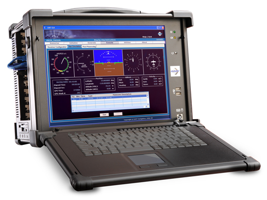
For users to take full advantage of signal diversity, they must have the best software-defined user equipment available. And the best equipment, if it were available today, would be the PHGPST or Perfect Handheld GPS Transceiver, which has so often been a popular topic of discussion over the last several years. I cannot count the thousands of letters and emails from warfighters, first responders, and civil users who immediately see the value of software-defined receivers and want to know where to purchase the PHGPST. For now, some early GPS software-defined user equipment does exist, but to reach the goal of the PHGPST, receiver manufacturers must first be able to accurately and reliably simulate/generate all the diverse PNT (position, navigation and timing) signals available, which include some signals not ordinarily categorized as PNT signals today. Certainly not an easy task; however, there is hope. Recently, I heard about a small GNSS/INS simulation company that may be paving the way to the PHGPST — CAST Navigation in Tewksbury, Massachusetts.
CAST Navigation
CAST Navigation, which qualifies under current federal acquisition guidelines as a small company, bills itself as, and my military contacts confirm that they are indeed, a leading provider of GPS signal simulators, as well as a company that supports navigation system research, development, integration and testing at commercial and military laboratories worldwide. CAST develops cutting-edge GNSS/INS simulation systems with an expert staff that provides their customers with the latest technology and knowledgeable, experience-driven support.
Tough Industry
Those of you who are real GPS techies should not have to think very hard to call up the names of at least three GPS–PNT signal simulation companies that have gone belly-up in the past five to ten years, and some of those memories are just plain painful for the U.S. military and industry alike. This can really be a tough business.
According to Susan Gove, vice president of CAST Navigation, “…the signal simulation field is certainly not an easy business and it is extremely competitive, but we have been around for a long time and are doing well,” which is exactly why a company like CAST Navigation — which has survived and grown for the last 25+ years with an outstanding track record — is of such interest when it comes to PNT signal diversity and the PHGPST.
Add the fact that recent Information Assurance (IA) and cyber security requirements have just made the GNSS business tougher for all concerned and a reliable, professional, flexible GNSS/INS signal simulation company becomes critically important to the industry as a whole. According to John Clark, VP for Engineering at CAST Navigation, “…our scenario-based software simulations, which include jamming, interference, multipath signals and spoofing allow for simultaneous and multiple scenarios — indeed, almost any battlefield signal perturbation the user needs to simulate is doable with our hardware and software. In fact, we routinely help our customers tailor scenarios for specific needs, and our customer feedback mechanism tells us our customers are extremely happy and productive with CAST Navigation’s scenario-driven software capabilities.”
A major requirement for signal diverse solutions to GNSS issues — to include jamming, unintentional interference and high masking angles — is the right antenna. Conventional wisdom says the right antenna is a Controlled Radiation Pattern Antenna or CRPA. Ideally, the right CRPA will eventually be capable of receiving all space-based PNT and SBAS signals (GPS, GLONASS, Galileo, Beidou, WAAS, EGNOS etc.) as well as ground-based cellular and LF (low frequency) and/or eLORAN signals. The CAST-5000 Wavefront simulator allows companies and the military to perform a full end-to-end test of a platform’s CRPA, the antenna electronics, and the GPS receiver before that receiver is ever deployed to the field. So it is a must-have capability for the truly signal diverse GPS receiver manufacturer. But to be honest, GPS signals are still key; they are still the gold standard for PNT. I am not aware of any GLONASS-only receivers on the market today, nor am I aware of any Galileo-only receivers being planned. GPS is the key component for available, reliable, and accurate PNT data.
Recently at the Munich Satellite Summit, all the European receiver manufacturers were touting GPS receivers with the Galileo/GLONASS option. Even if the marketing brochures list Galileo or GLONASS first in the name, a little probing makes it obvious that the primary baseline PNT system is GPS with augmentations. So although signal diversity is the goal and more and more systems are, to some extent, signal diverse or signal-diverse capable today, the reality is that GPS is still the Gold Standard. If we are ever to truly enjoy signal diversity and all the associated benefits, PNT signal generators and simulators will be a key developmental tool. To that end and with affordability in mind, CAST Navigation has the capability or is in the process of developing simulations for many of the diverse signals mentioned to include SAASM signals for the U.S. military and our allies.
Simulations and Predictions
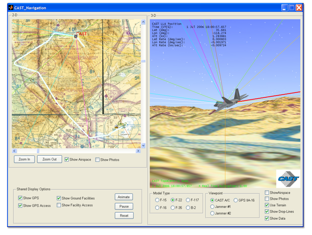
For the past several years the DoD and several government agencies have made good use of a very functional PDOP (positional dilution of precision) prediction algorithm and tool named GIANT. General Dynamics originally developed the GIANT program under contract to the U.S. government. Currently, GIANT is being enhanced primarily by LINDQUIST, with the help of select government agencies; with the recent integration of Google Maps, GIANT is proving to be a very useful tool for the warfighter and first responder. Amazingly CAST Navigation has a very similar product that is available for all users to include the U.S. military. The CAST product is called TOP or Terrain Obscuration Program. Like GIANT it provides a real-time determination of satellite visibility based upon the terrain (presented in a 3-D visualization) surrounding the actual position or predicted position of specific GPS receivers, fixed or mobile.
(Click to enlarge.)
While this concept sounds a bit academic at first, when you see it in action and talk to warfighters and planners who have benefited from GIANT first hand, it is clearly a mission-success parameter as well as a life-saving capability. For years GIANT was purely a flat Earth planning tool, and while it was useful, the addition of real-time processing, Google Maps, and DTED data have made both GIANT and TOP incredibly useful programs. Both programs help ensure GPS user equipment, applications, and weapon systems are more accurate, since signal availability is now predictable. The first time I saw the new GIANT tool in action, it literally took my breath away, and now that capability is available for everyone with the TOP product from CAST Navigation. Knowing first-hand what both GIANT and TOP are capable of for warfighters and first responders, I cannot now imagine a government, commercial, or civil planner, who must utilize or install GPS equipment or systems that depend on GPS capabilities, that would not benefit from these groundbreaking programs. In a natural or urban canyon situation, with high masking angles, installing GPS receivers or antennas with the greatest visibility would be pure guesswork without a program like TOP that guides planners and installation engineers with real-time data extrapolating optimal PNT reception locations, both fixed and mobile, over time.
SGX
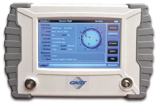
Combine the capability of GIANT or TOP with a portable or handheld GPS signal generator/simulator, such as the new handheld CAST SGX, and users are able to accurately characterize and predict the effects of area terrain and masking angles on any GPS receiver prior to actually venturing into the field. Users are able to determine which receivers will function optimally and produce the most reliable results in any physically constrained or sky-challenged environment. For both government and civil users, the fidelity of TOP and GIANT are a direct function of and only constrained by the Digital Terrain Element Data (DTED) access authorized for specific users.
The CAST SGX (signal simulator/generator) is a GPS signal device housed in a portable lightweight handheld enclosure. In other words, it is a portable handheld GPS signal device at home in the laboratory, running on house current, or in the field running on long-life batteries. Regardless of the power source, the CAST SGX is capable of generating GPS L1 signals (with P-Code options) of up to 16 GPS satellites, which are more than most users would normally have in view at any one time.
The CAST SGX is an important new development in GPS signal simulation and generation. Historically GPS signal simulators/generators have been huge, heavy and complicated pieces of laboratory equipment requiring a Ph.D. to run properly, and users were tied down to evaluating GPS receivers only where the unwieldy GPS signal simulator/generator was located. Now with the portable CAST SGX, the signal generator can go where the receivers are located and real-world data can be collected in real time. The scenarios the SBAS (satellite based augmentation system) capable SGX have made available are extraordinary, and I have purposefully not speculated on the military possibilities as those speculations become classified in a hurry. But just allow your imagination to wander a bit and you will see what I mean.
SGX Software
The optional CAST-XGen Plus software, which I have not had a chance to personally test but hope to in the near future, has the capability to integrate with Google Maps and reportedly gives the user the ability to generate advanced customized scenarios for use with the SGX device. The software allows for complete control over atmospheric effects, the GPS almanac, ephemeris and all satellite error sources to include masking angles and multipath. So you don’t actually have to take the SGX device out into the field, but the great part is now you can. Ruminate on that for awhile and the possibilities appear endless.
According to Susan Gove, the handheld SGX is proving to be a huge success, and the SGX along with CAST Navigation software products will be available at the ION 2012 Joint Navigation Conference (ION JNC) June 12-15, at the Crowne Plaza Hotel in Colorado Springs, Colorado. Be sure to stop by and take a look at this amazing new product.
Bottom Line
I am impressed by what I have learned about CAST Navigation. They are a small, agile, innovative GNSS/INS simulation company that has brought much needed portability and availability of GPS signals and simulation to operators, planners, and system designers worldwide. CAST Navigation hopefully has a bright future and may well play a key role in the future of the availability and integrity of GPS signals for users globally. They may also help blaze the path to the PHGPST. Check them out at ION JNC.
Because LBS Insider’s deadline is this week, CTIA coverage from New Orleans is not included in this month’s column. Janice Partyka, editor of GPS World’s Wireless Pulse, is covering CTIA in the Crescent City for the latest location-based services, M2M, and connected vehicle news. So instead of talking about CTIA (and why there aren’t many pure LBS players or sessions there anymore), this column examines the hype surrounding indoor positioning — is it LBS’ savior, or just another technology that may, or may not, pan out?
The location industry will know very soon whether indoor positioning is just another overhyped technology niche — or the needed capability that will drive the largest advertisers and retailers to finally embrace location-based services. Some industry analysts say indoor location may take off in as few as 12 months — particularly if smartphones include the feature in new product offerings.
At several location industry conferences, the obligatory indoor positioning panel is cropping up, leading some to believe that while intentions are good, perhaps the technology hasn’t developed fast enough. The jury is still out on indoor positioning. “It is badly needed, but also needs to be down to the meter-level,” said Ralph Eschenbach of Sand Hill Angels, a venture capital firm, at the recent GPS-Wireless 2012 conference. “The technology is not here yet.”
Another contrarian said that industry segments like automakers need not just show users how to navigate to destination, but give folks information when they near the area. “It would be nice if a BMW told me where’s the cheapest gas,” said Gary Gale, Nokia director of places, location and commerce.
Some analysts, like those at IMS Research, believe that an indoor positioning technology will be from multiple sources — though Wi-Fi has been the primary tech solution. IMS cites reports that say Bluetooth in Nokia’s HAIP can meet the one-meter threshold of accuracy for indoor markets.
IMS said the major indoor positioning players, so far, are Google, Qualcomm, Broadcomm, CSR, Qubulus, Nokia, NextNav, and Path Intelligence.
While intangible benefits such as measuring consumer behavior and shopping experience will be important for retailers and advertisers who are hoping to fund indoor positioning systems, the goal is to drive customers to the stores. This will also be tied into the “what do I do when I get there” answer to the navigation question.
Still, the benefits will be transparent to advertisers once consumers are able to save time, and perhaps money, with indoor positioning capability on their smartphones, said Ankit Agarwal, CEO of indoor positioning company, Micello. “There is definitely a business model for indoor positioning. It enables product search and walking paths throughout a store,” he said. “Stores will be able to track multiple routes folks are interested in taking [through a store].”
Once again, Google seems to be the major player in indoor positioning. LBS Insiderreported late last year that Google went indoors with the launch of Google Maps 6.0. The company has attracted some of the big-box retail stores such as IKEA, Macy’s, Home Depot, and Bloomingdales to have their stores mapped. However, a lot of the bigger malls, and Target and Wal-Mart, have not been mapped. The Google product tells customers what floor they are on in a building, but so far is only available for Android.
Google’s indoor mapping partners include 18 U.S. airports, which will open up more partners and LBS relationships in the future.
In other news, but related to indoor positioning and other LBS markets, Greg Tarr, partner at Rogers Venture Partners, said at GPS-Wireless: “There is no privacy…get over it.”
TomTom Launches Global Geocoding Web Service
As GPS World reported, TomTom launched a new volume batch geocoding web service late last month at the Geospatial World Forum in Amsterdam. Geocoding, the process of converting addresses into geographic coordinates to allow location analysis for businesses, is taking on a new twist with the new product.
“This not your father’s geocoding. The turn-around time to download the product will be attractive to companies,” said Dan Adams, TomTom vice president, location and live services. “When I was with GDT and we were acquired by Tele Atlas, it gave us more exposure to global geocoding. Since the TomTom acquisition, there has been a recasting of those products, with the same sort of dynamics, but bringing them to the Cloud.”
What Investors Look for in a Location Company
In a venture capital panel at GPS-Wireless, industry experts basically say that location markets mean more than just navigation now. They also have some strong opinions on the composition and strategies of companies they plan to invest in.
“We notice that some startups don’t have enough engineers,” said Sanjay Subhedar, Storm Ventures managing director.
Other VCs say they look first at the market size of the location niche, but still believe the personality of the company’s management team is important. However, there was no location market segment any VC agreed on; some were sold on the promise of enterprise markets; others believe a strictly consumer play is where the future is.
LBS Insider Covering ITS America Conference
Not a sexy show like CTIA or Telematics Detroit (which is being boosted by the connected car craze, despite its jaw-dropping price to attend), ITS America’s annual meeting this month in the Washington, D.C., area will feature connected vehicle sessions and government programs. Before market-centric conferences as Telematics Detroit and Where 2.0, ITS America, even with its government focus, was the only game in town for companies looking to get into the navigation and location business.
One of these “government programs” traditionally featured at ITS America is distracted driving sessions, which at least one analyst says younger drivers don’t want to be bothered with. “Only 20 percent of young consumers are worried about distracted driving [we found in our studies],” said Thilo Koslowski, Garnter vice president, who also said, unlike what some automakers and analysts believe, that a car is not a “laptop with four wheels.”
LBS Insider will be covering the ITS America annual meeting. If attending, contact us with your story ideas.
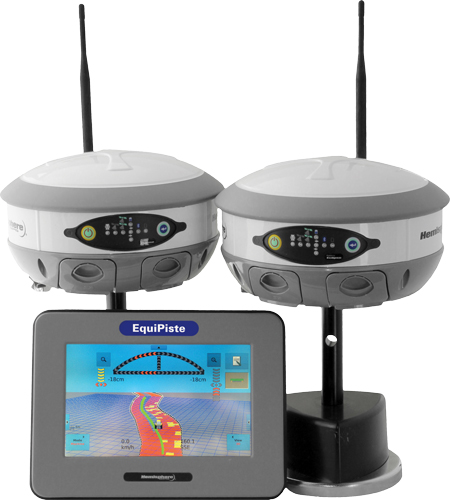
Hemisphere GPS has announced the EquiPiste integrated snow grooming management system. EquiPiste provides visual guidance, snow depth status, and event logging for snow grooming operators, mountain managers and snow road operations. Ski resorts benefit from improved grooming quality and productivity, optimal snow making decisions and distribution, as well as more predictable and preventative snow cat maintenance, according to Hemisphere GPS.
Snow grooming operations are tasked with creating quality snow conditions for ski trails or pistes, as they are referred to in the industry. Designed with an integrated touchscreen terminal and Crescent GPS, Hemisphere GPS’ EquiPiste graphically displays to the operator the areas groomed, boundaries, assets, points of interest, and hazards. Through the guidance cues, operators increase their efficiency and quality of work by avoiding overlaps and skips in grooming, Hemisphere GPS said. Areas that need attention such as thin snow pack and winch anchors can be flagged with meta-data so operators can easily navigate back at any time, even in low visibility. Pathways can be mapped and re-used for training novice operators or for repeatedly navigating snow roads. Operation managers benefit from reviewing the job files from each machine to determine variable costs, performance and maintenance tracking, the company said. As well, data can be mapped within Google Earth and used for generating daily grooming or road maintenance reports for customers.
Many ski resorts also spend a substantial amount of their budget on snow making activities. When combined with Hemisphere GPS’ survey grade Eclipse GNSS technology, EquiPiste displays and records real-time snow depth measurements and maps, the company said. The snow depth data improves the efficiency and quality of managing the snow levels. The depth data helps indicate where and when to make snow, it alerts the operator to thin snow pack, where to redistribute snow as well as how to identically recreate (day to day and year to year) downhill race courses. Analysis of the snow depth data enables more optimized snow management.
“Through collaboration with the ski resort and snow vehicle machine industry we have customized existing Hemisphere GPS technology to serve an adjacent vertical market,” said Andre Roberge, senior manager of New Ventures at Hemisphere GPS. “EquiPiste is truly a comprehensive snow management system that allows ski and snow road operations to capture and visualize the status and behaviour of snow for optimized grooming and manufacturing. Our customers have experienced tremendous benefits in productivity, quality, and safety as well as significantly reduced operational expenditures and lowered environmental impact. As a result, EquiPiste customers are able to provide a better standard of service and experience to their customers.”
Event 38 announced its first major product, model E382, a ready-to-fly mapping UAV. Based on the Ardupilot Mega 2.0 autopilot, the E382 is designed to take aerial photos quickly and easily.
According to the announcement, equipped with a small point and shoot camera, the E382 can make five centimeter resolution maps from individual pictures stitched together. Digital elevation models and georeferenced orthorectified maps can be made using online services like DroneMapper.com.
Event 38 reports that the E382 is capable of flying for just under an hour and can cover over 200 acres at a time on one charge. For larger areas, replacing the battery is quick and can be done in the field. Weighing in at under five pounds and made of soft, durable foam, the airframe is resistant to damage and can’t significantly damage anything on the ground. The 66″ wings come apart for easy transport to and from the job site.
The basic kit consists of a ready to fly airframe with autopilot, motor and servos installed. Options are available to add on for those without any R/C gear like a controller, batteries and a suitable point and shoot camera. If you’re starting without any gear, a full system costs about $1,050. Training and on-site setup are available as well.
Large coordinated cyber attacks from North Korea near its border with South Korea produced electronic jamming signals that affected GPS navigation for passenger aircraft, ships, and in-car navigation for roughly a week in late April and early May. To date, no accidents, casualties, or fatalities have been attributed to jammed navigation signals aboard 337 commercial flights in and out of South Korean international airports, on 122 ships, including a passenger liner carrying 287 people and a petroleum tanker. One South Korean driver tweeted “It also affects the car navigation GPS units. I am getting a lot of errors while driving in Seoul.”
South Korea experienced similar electronic attacks in March 2011, and in August and December of 2010, all of which were blamed on the North. The South Korean Defense Ministry said it is developing anti-jam programs to counter the attacks, which are being launched by what it termed a regiment-sized electronic warfare unit near the North Korean capital Pyongyang, and battalion-sized units closer to the inter-Korean border.
“Despite disruption in GPS, there is no serious threat to the safety of flights because planes are using other navigation devices,” claimed a Transport Ministry spokesperson. Officials say planes can use other navigation devices like very-high-frequency omni-directional range (VOR) and inertial navigation systems.
“We have traced the jamming signals to the direction of Kaesong,” said a Korean Communications Commission deputy director. Kaesong lies roughly 10 kilometers from the border between the two countries, and roughly 50 kilometers from downtown Seoul, Incheon International Airport, and the Yellow Sea.
It is unknown how long the jamming may continue, or when it might resume if halted. In March 2011, GPS jamming signals from the North lasted for 10 days during an annual U.S.-South Korea joint military drill. The motivation for North Korea to develop and employ anti-GPS technology would appear to come from its fear of attack by GPS-guided cruise missiles that might target key sites within the country. Clearly, any such military capability would require regular testing.
China is well known as a source of mass-produced small GPS jammers widely available over the Internet, but equipment on this scale would not be capable of jamming at the distances stated above. “At least one, or possibly more Russian companies are selling fairly powerful GPS jamming equipment,” said one knowledgeable source.
The source also alluded to Iran’s reported use of GPS spoofing to mislead and capture a U.S. surveillance unmanned aerial vehicle (UAV). Such an effort would similarly require large and sophisticated equipment, for which the most likely source is Russia.
“Receivers which cannot tolerate LightSquared will get in trouble in North Korea!” commented one well-known GPS manufacturer. “Today’s receivers don’t have protection. We just completed our ad [for the June issue of GPS World] which somewhat covers this.”
Other sources pointed to much wider potential threats than those in the Korean peninsula or areas of strategic conflict such as Afghanistan-Iran. Local jamming attacks can be anticipated almost anywhere, anytime: harassment by insurgent groups against established governments or armed forces, or GPS-denial actions by pirates in high-density commercial shipping lanes.
Since aviation is increasingly and in some cases exclusively dependent on GPS and regional GNSS augmentations or equivalents, jamming represents a growing concern for the aviation industry, including commercial airlines. In March of this year, the U.S. Federal Aviation Administration published an updated report on “Concept of Operations for NextGen alternative positioning, navigation and timing (APNT).” It advocates GPS backup by transponder-based distance-measuring equipment (DME), supported by onboard inertial reference systems, and assisted in places by low-powered GPS-like pseudolites and wide-area multilateration. The report concludes that any GPS/GNSS backup must be multi-modal, unjammable, provide GPS-like timing, have signals extending from the ground up to all altitudes, be unaffected by line-of-sight restrictions and, preferably, have reasonably long range to keep down the number of transmitting stations required.
Commenters have pointed out that eLoran meets those requirements, except for a vertical component, limiting it non-precision approaches. The system currently does not operate in the United States, although it is undergoing limited testing. The United Kingdom has a more active program. See upcoming GPS World webinar, Alternative PNT – Backing Up Critical Infrastructure with eLoran, on May 17.
This is an interesting look at the five and ten year vision of geospatial information management from the United Nations, a collection and summary of industry expert opinions. According to its website, “the UN initiative on Global Geospatial Information Management (GGIM) aims at playing a leading role in setting the agenda for the development of global geospatial information and to promote its use to address key global challenges. It provides a forum to liaise and coordinate among Member States, and between Member States and international organizations.”
UN Committee of Experts on Global Geospatial Information Management
Future trends in geospatial information management: the five to ten year vision
Background
At the inaugural meeting of the Committee of Experts on Global Geospatial Information Management (GGIM), held in Korea in October 2011, it was decided that there was a need to document the thoughts of leaders in the geospatial world as to the future development of this world over the next 5 years and then looking further out, to thoughts as to its development over the next 10 years. In particular, the Committee was interested in how these developments will contribute to the local, national and global strategic agendas of economic growth, social cohesion and wellbeing, environmental sustainability, disaster management, public safety and good governance. A number of experts and visionaries across a wide range of aspects of the geospatial community – from data collection experts, academics and major users of geospatial information, through to leading figures from the private sector and the Volunteer Geographic Information (VGI) movement – have been invited to contribute their views on the emerging trends in the geospatial world. Responses have now been received from individuals across the broad spectrum of the geospatial community.
This paper briefly summarises the main themes and trends identified in these responses. It is designed to inform further discussion to take place alongside the Geospatial World Forum in Amsterdam in April 2012. Output from that session will then be used to develop further iterations of the document to be presented to the Committee for review at its second formal meeting in New York in August (13-15th August 2012). Final editing will take place based on the content of the discussions at this meeting and a final paper will be presented at the Second High-Level Forum on GGIM in Qatar in 2013.
Executive Summary
The use of geospatial information is increasing rapidly. There is a growing recognition amongst both Governments and the private sector that an understanding of location and place is a vital component of effective decision making. Citizens with no recognised expertise in geospatial information and who are unlikely to even be familiar with the term are also increasingly using and interacting with geospatial information, indeed in many cases they are contributing to its collection.
As with all technology-driven sectors, the future is difficult to predict. However, this paper takes the views of a recognised group of experts from a wide range of fields related to the geospatial world and attempts to offer some vision of how this is likely to develop over the next 5-10 years.
This paper will look at a number of aspects of the geospatial world in order to attempt to provide a tangible vision of where this community, providers, practitioners, and users, are heading. Based on contributions received, these trends have been broken down into broad themes covering major aspects of the geospatial world, as follows: data creation, maintenance and management; uses of geospatial data; trends in technology; legal and policy developments; skills requirements and training mechanisms; the future role of National Mapping Agencies; and the role of the private sector and volunteer geographic information.
Future direction of data creation, maintenance and management
Contributors noted the exponential growth in capture methods – the volume of data that will flow in, the increased potential of “traditional” positioning and capture methods such as the use of Satellites, but also the introduction of new (to geospatial information) methods such as Unmanned Aerial Vehicles (UAVs) and Social Media. The responses considered the challenges of bringing these datasets together into manageable environments, particularly as the capture, processing and distribution of this data becomes more “real-time”.
Uses of geospatial data
The experts’ view is that geographic information will become ubiquitous in almost every aspect of government and of citizens’ lives. In its most positive aspects, crisis response will be greatly enhanced through the wide availability of more accurate, timely and accessible data – satellite flight paths can be changed, UAVs launched, and crowdsourced data ingested in real-time. This data will not only assist immediate response but facilitate better planning and long-term recovery. The data will also facilitate better governance by providing citizens with richer information and will support economic growth through enhanced resource planning, and therefore improved decision-making. However, this does come with risks as the pervasive availability of information, especially where citizens act as passive and even unwitting data providers, does increase the potential for misuse by both state and private organisations. Hence there is a need for vigilance and appropriate ethical standards, and accountability in this area.
Trends in technology (including future of delivery mechanisms for geospatial data)
Responses received from contributors have emphasised that technological evolution will continue to accelerate, with a key trend being the way that previously niche geospatial information technologies will become mainstream, whilst at the same time mainstream technologies such as the Cloud and Software as a Service are absorbed into geospatial information. Data will be increasingly interconnected through the web via capabilities such as Linked Data and this will challenge current standards methods. Contributors highlighted that technology will enable rapid distribution and absorption of information, and also accelerate responses to that data to the extent that location devices will be pervasive – everything and everyone will be locatable. Alongside this, respondents noted the emerging trend towards the provision of 3D and even 4D geospatial information. Responses emphasised these major technological developments and considered how this potential can be exploited to
meet global goals.
Legal and policy developments
There were a myriad of legal and policy issues highlighted by contributors that are likely to impact the geospatial world over the coming five to ten years. The trends identified include issues related to the increasing demand for free and open access to geospatial data; the privacy challenges related to the growing number of devices that act as geospatial sensors; the potential gap between legal and policy developments in the geospatial world, and developments in the legal and policy frameworks of interrelated issues such as privacy, national security, liability and intellectual property; the potential legal status of national spatial data infrastructures; and other governance roles expected to be required in relation to geospatial information.
Skills requirements and training mechanisms
Understanding what the skills requirements and necessary training will be in the next five to ten years will be an important component of ensuring the value of geospatial information is maximised. Responses discussed the likely changes that will take place as interaction, analysis and use of geospatial information continues its shift from the domain of a relatively small group of experts to the wider populace. Respondents also gave consideration to the likely impact of the transformations and intersections between geospatial information in what may be viewed as its traditional form and geospatial information as data, particularly in light of the expected proliferation of this data over the coming five to ten years.
The future role of the National Mapping Agencies
Contributions have highlighted that, as in the last five to ten years and the decades prior, the role of National Mapping Agencies will inevitably continue to evolve over the next five to ten years. Responses suggested that Governments are likely to continue to play a major role in securing and guaranteeing the quality of the fundamental geospatial information base, and in overseeing the principles and arrangements required to ensure authoritative frameworks are maintained. Contributors also highlighted the challenges and opportunities that will develop as a result of the increasing availability of crowdsourced data and the involvement of the private sector in the geospatial world, particularly in ‘competitive’ geographies. Consideration was given to how these trends will impact the role of National Mapping Agencies, and how these different data providers can complement each other.
The role of the private sector and voluntary sector
In addition to considering how the private and public sectors can work together to benefit the citizen, respondents explored a wide range of trends in the private sector and within the volunteer geographic community and discussed how these will evolve, Ten years ago few would have predicted that Google would be a large provider of location information to the citizen, or that most citizens would be buying location services and devices. Respondents noted that we have also seen the private sector begin to challenge the National Mapping Agencies in data collection and maintenance, especially for cross-border solutions, where the national remit of traditional providers is a barrier to users. Contributions also discussed the other extreme, where citizen and voluntary groups have seized the opportunity of new technology to develop initiatives such as Open Street Map and Map Action to complement and even challenge traditional data providers.
Annex A: Future trends
Key emerging trends identified as a result of the input received include:
The growing number of sensors in everyday devices, which collect and provide geospatial information, will increase and alter the dynamic of data collection. This will also increase the role of geospatial data creation and collection by citizens, both active and passive.
New data will be created on top of accurate geospatial data using real-time user information available through social media and other web uses.
There will be an increased demand for applications to be used with high-resolution imagery.
The use of Unmanned Aerial Vehicles (UAVs) as a tool for rapid geospatial data collection will increase.
3D and even 4D geospatial information, incorporating time as the fourth dimension, will increase.
Developments in technology mean that collaboration on data collection and management will increase, with different aspects carried out in different parts of the globe.
The emergence of new independent Global Navigation Satellite Systems (GNSS) will require a concomitant system for unification.
Demand for geospatial data will increase, particularly in developing countries, as they look to develop different sectors of their economies.
Education and broader capacity building will play a vital role in this field, ensuring that both the skills required to make best use of spatial information are available and that key decision-makers are aware of the value of this information.
Citizens’ familiarity with information that has a spatial aspect to it, particularly through the use of Location Based Services, will continue to increase.
People will change and adapt as they become more familiar with technology and handling of data streams, and will become increasingly adept at recognising trends (spatial, temporal and causal) within the vast quantities of data that will likely be available.
Analysis and reasoning based on data may start to form part of Spatial Data Infrastructures, as the concepts of infrastructure as a service, IaaS, platform as a service, PaaS, and software as a service, SaaS, evolve further on to model as a service, MaaS.
The provision of data as Linked Data, similar to the www where documents are linked together, will increase and will be widely implemented within the next 5 years, replacing current exchange standards (e.g. GML).
There will be a dramatic push to give access to both imagery and applications to end‐users anytime, anywhere.
The cloud will become increasingly important as a delivery mechanism for geospatial data. It will also have a significant impact on current business models.
Technology will move faster than legal and governance structures.
Low-cost low tech sensors will proliferate.
Gaming may inspire new developments as opposed to traditional geospatial information.
The link between geospatial information and social media, plus other actor networks, will become more and more important.
Real-time information will enable more dynamic modelling and response to disasters.
Metadata and other ways of dealing with the increasing amounts of data that will be available will be increasingly important.
Free and open source software will continue to grow as viable alternatives both in terms of software, and potentially in analysis and processing.
Earth observations systems will be increasingly improved and make the satellite imagery of any place at any time available.
Geospatial computation will increasingly be non-human consumable in nature, with an increase in the number of fully-automated decision systems.
Businesses and Governments will increasingly invest in tools and resources to manage Big Data. The technologies required for this will enable greater use of raw data feeds from sensors and other sources of data.
Global demand for Location-Based Services will continue to rise and should lead to geospatial information achieving ubiquity.
The widespread use and creation of geospatial data will lead to the establishment of a geospatial infrastructure. Society will increasingly rely on this infrastructure, much as it has become dependent on other, more traditional forms of infrastructure, such as electrical grids or highway networks.
Within five years GNSS modernisation will have a significant effect on all classes of positioning – from high end, geodetic quality applications such as orbit determination of low earth orbiting satellites and warning systems for earthquakes and tsunamis, down to consumer grade devices in phones and PDAs. Positioning will be more accurate, with lower latency and greater integrity. Integration with other sensor sets (typically low cost MEMS devices and compasses) will also have developed significantly. Positioning devices will work reliably in far more places than they currently do, and because of this, applications enabled by the technology will spiral upwards in terms of volume and sophistication.
In ten years time it is likely that all smart phones (or whatever replaces them) will be able to film 360 degree 3D video at incredibly high resolution by today’s standards, and wirelessly stream it in real time. Such devices would likely be carried or worn by workers in situations where it would be useful for their colleagues (back at the office or in the field) to be able to see what they are seeing – for example police officers, firefighters, utility workers, etc. They would also be mounted in many vehicles, at street intersections, etc. This network of devices will provide data that can be merged in real time to give an immersive video view of the world.
Augmented reality applications will be pervasive, with the ability to view a whole range of data overlays on top of the real world.
We will see significantly more diversity in the geospatial market than we have had over the past couple of decades. We are likely to see much more influence from video games, in terms of dynamic graphics and 3D visualization. This will be another driver for a new generation of software to replace today’s incumbents.
There will be a need for geospatial use governance in order to discern the real world from the virtual/modelled world in a 3D geospatial environment.
Free and open access to data will become the norm and geospatial information will increasingly be seen as an essential public good.
Funding models to ensure full data coverage even in non-profitable areas will continue to be a challenge.
Privacy will continue to be a major battleground.
Rapid growth will lead to confusion and lack of clarity over data ownership, distribution rights, liabilities and other aspects.
Protection of data from processes like data ‘scraping’ will be an issue.
Legislation will increasingly recognise digital signatures as digital cadastre/deeds will become the norm.
In five years, legal and policy communities in most parts of the world will be getting to grips with the power of geospatial technology and some of the unique aspects of geospatial data. However, in many areas of the world a consistent and transparent legal and policy framework will not have developed with regards to such matters as privacy, national security, liability and intellectual property. This will cause a number of issues.
In ten years, there will be a clear dividing line between winning and losing nations, dependent upon whether the appropriate legal and policy frameworks have been developed that enable a location-enabled society to flourish.
Some governments will use geospatial technology as a means to monitor or restrict the movements and personal interactions of their citizens. Individuals in these countries may be unwilling to use LBS or applications that require location for fear of this information being shared with authorities.
Supervision and regulation of geospatial information according to law will prevail, with governments paying increasing attention to the authoritativeness and accuracy of geospatial information.
National geospatial data infrastructures will be planned, developed and maintained as statutory infrastructures.
The deployment of sensors and the broader use of geospatial data within society will force public policy and law to move into a direction to protect the interests and rights of the people.
Location awareness should form a core component of the Internet of Things.
Capacity development and educational programmes will need to be tailored to individual country needs.
Spatial literacy will not be about learning GIS in schools but will be more centred on increasing spatial awareness and an understanding of the value of understanding place as context.
Staff at National Mapping Agencies will have to be rationalized and retrained to acquire multidisciplinary skills.
As well as playing a major role in securing and guaranteeing the quality of base geospatial information, governments/National Mapping Agencies will take on an additional role as geospatial information manager, and playing a guiding role in guaranteeing the quality and reliability of software used in creating user specific geospatial realities.
Government’s roles may increasingly be one of compensating for market failure as opposed to providing the complete geospatial framework.
The role of National Mapping Agencies as an authoritative supplier of high quality data and of arbitrator of other geospatial data sources will continue to be crucial.
National Mapping Agencies set up with large numbers of staff within individual specialist units will change.
Monopolies held by National Mapping Agencies in some areas of specialised spatial data will be eroded completely.
More activities carried out by National Mapping Agencies will be outsourced and crowdsourced.
Crowdsourced data will push National Mapping Agencies towards niche markets.
Government should provide leadership and establish/oversee frameworks.
National Mapping Agencies will be required to find new business models to provide simplified licenses and meet the demands for more free data from mapping agencies.
The integration of crowdsourced data with government data will increase over the next 5 to 10 years.
Crowdsourced content will decrease cost, improve accuracy and increase availability of rich geospatial information.
There will be increased combining of imagery with crowdsourced data to create datasets that could not have been created affordably on their own.
There will be no more than ten global providers of geospatial information services in the world.
Progress will be made on bridging the gap between authoritative data and crowdsourced data, moving towards true collaboration.
There will be an accelerated take-up of Volunteer Geographic Information over the next five years.
In all geographies without market failure, the private sector will wish to compete with traditional players.
Crowdsourced sensoring will emerge.
Within five years the level of detail on transport systems within OpenStreetMap will exceed virtually all other data sources and will be respected and used by major organisations and governments across the globe.
Community-based mapping will continue to grow.
There is unlikely to be a market for datasets like those currently sold to power navigation and location-based services solutions in 5 years, as they will have been superseded by crowdsourced datasets from OpenStreetMaps or other comparable initiatives.
National Mapping Agencies are likely to find it difficult to justify the costs of traditional data maintenance mechanisms as their products are used in increasingly niche areas.
CMT Release iCMTGIS II App for the Apple iPAD, one of a series of apps the company is presenting to the iPAD and iPhone users in 2012. iCMTGIS II provides a host of powerful and user-friendly functions to facilitate GPS/GIS data collection and mapping for a variety of applications, such as forestry, land management, utility pole data collection, wildlife management and archaeology.
iCMTGIS II functions include:
Display the coordinates of a geographic location
Create Feature Lists for data collection
Create sampling grids
Display Google Map as the background map
Import and Export Shapefiles
Collect multi-layer GPS/GIS data
Update the coordinates for Point Features
Create new points using angles and distances
Digitize points, lines and areas
Assign symbols and attributes to Features and Topics
Esri announced the release of a free Business Analyst Android app for retail and commercial real estate professionals, allowing them to access demographic data anywhere with the Esri Business Analyst Online (BAO) application. The application is designed for anyone who needs access to population and consumer marketing data on the go.
According to the announcement, the BAO application enables users to access up-to-date facts on demographics, lifestyle, and consumer spending for any region in the United States. With it, users can compare any address with another or with the county, state, or United States and analyze an area within one mile of a prospective location. Unlike traditional market research, users can quickly compare and contrast regional information with the regional average and show that data to clients in the field. Reports created in the mobile BAO application can also be e-mailed to share with a broader audience. More extensive data, capabilities, and reports are available through the application with a subscription to the BAO web application.
The BAO application is free and can be downloaded directly from Android Marketplace.
Between 2010 and 2011 the global installed base of app consumers increased by 104%, according to a report released by mobile research specialists Research2guidance. While the installed base of smartphones increased by nearly 274 million, tablets were the fastest growing segment. The number of new tablet app consumers increased by 58 million. As a result, tablet owners now constitute 8.6% of the installed app consumer base.
Based on Q2 projections for tablet shipments in 2012, the installed base of tablet users is set to increase more than 150% by 2013. As tablet users become a larger and larger app downloading segment, their app behavior and preferences will have an increasing influence on the app market – illustrated already in the growth in the number of apps and stores devoted to them.
Installed base of tablet users to increase more than 150% by 2013
During 2011, apps in the Apple App Store for iPad grew 180% to more than 140,000 apps by the end of Q4 2011. While this cannot be easily quantified for Android as tablet apps are not separated out, the growth of niche stores and niche store categories focusing on Android tablets reflects their growing presence. For example, Archos Appslib focuses completely on Android tablet apps, while other stores like Android Tapp has a dedicated category.
Several studies have shown that tablet users exhibit different behaviour towards app downloading/usage and mobile browsing than smartphone users. Based on the breadth of use cases for gaming, ecommerce, digital publishing and the enterprise – tablet user growth is likely to have a marked effect on consumption in these areas.
Tablet apps for the enterprise market
In the enterprise, for example, tablets have already been largely implemented at upper levels of management and are quickly working their way throughout organizations – according to Apple’s CEO Tim Cook in 2012, 92% of Fortune 500 companies are testing or deploying iPads. As more and more use cases are developed and penetration increases, so too will the number of apps being developed for enterprise tablet users. While Apple has already carved out a niche section for iPad and iPhone Business users called “@Work”, other players like Lenovo and Cisco are trying to do the same for Android Business users.
Trimble introduced a new version of the Spectra Precision Laser DDS300 Depth Display System, a laser-referenced grade control solution targeted for compact machines. The DDS300 version 3.0 introduces a new environmentally-rated control box and new level of productivity for mini-excavators and backhoe loaders used for excavation and trenching work for basements, footers, utility lines and conduit. Cable-free components, simple installation and an affordable price make the DDS300 system ideal for contractors who want to improve accuracy, fuel usage and safety of their excavation operations.
According to the announcement, the DDS300 system utilizes wireless communications, a laser receiver and angle sensors to provide dynamic positioning information for the excavator or backhoe bucket at all times. Real-time grade guidance is displayed on the 7-inch in-cab display, allowing the operator to work faster and with better accuracy. Accurate positioning of the bucket also improves the safety of excavation by eliminating the need for a grade checker to work in the trench or machine swing area.
The new waterproof and sunlight-readable CB310 Control Box display is included in the DDS300 system and is rated IP-64, making it suitable for use in bright sun or inclement weather.
By Stéphane Gallot, Pascal Dutot, and Christophe Sajous
A new hardware assessment tool automates testing and mission replay, managing military GPS receiver input and output data, with an operational implementation and with a better control of initialization conditions, especially direct P(Y) acquisition. The test bench drives a GPS/Galileo simulator, a digital jammer, and software programs for visibility computation based on terrain modeling, and for multipath generation on 3D renderings.
Comprehensive assessment of military GPS receivers becomes more complex as they are integrated into advanced systems. To limit testing on systems under live conditions, laboratory evaluations with real elements are essential.
A new hybrid test bench called Statistical INERtial Gnss HYbrid in Simulation (SINERGHYS) is designed for governmental use to validate the integration of GPS/Galileo receivers within the navigation system for different platforms. As system-level requirements become more stringent, this bench has been designed to assess the behavior of the complete system in an operational context.
This new assessment hardware-in-the-loop tool is designed to automate testing and to replay missions with an operational implementation and with a better control of initialization conditions, especially direct P(Y) acquisition. This test bench drives many simulation tools: a GPS/Galileo simulator, a digital miniaturized jammer, and different softwares such as one enabling the computation of visibility depending on the terrain modeling, or one dedicated to the generation of multipaths on surfaces of realistic 3D scenes.
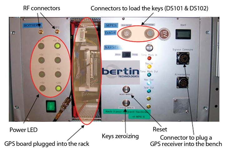
Figure 1. Depiction of SINERGHYS.Figure 2. Focus on the bench.
A Common Bench. Since 2000, with the arrival of the new cryptographic generation (the selective availability anti-spoofing module, or SAASM), the French government defence procurement agency (DGA) GPS laboratory decided to buy off-the-shelf GPS SAASM receivers that cover different form factors and applications. To test performance, it was necessary to acquire a test bench suitable for each GPS receiver. Testing procedures became more and more complex, and most of the manufacturer-provided benches could not perform every test required, such as direct P(Y) acquisition. To improve French expertise concerning GPS receivers, the DGA GPS laboratory decided to develop a common, generic test bench taking into account the integration constraints of each receiver. The perimeter of the hybrid test bench consists of a PC and a generic GPS test bench.
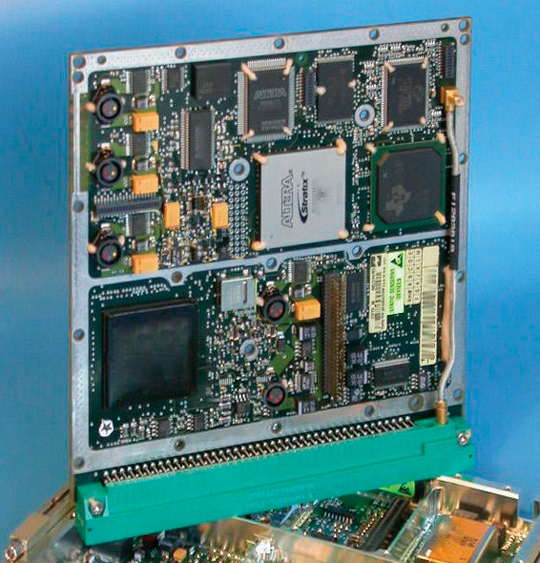
Figures 3 and 4 show examples of military GPS receivers integrated into the bench.
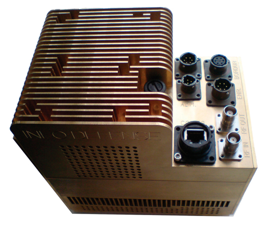
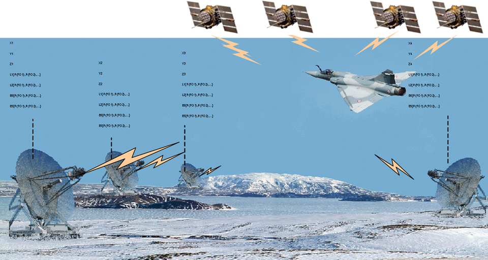
Figure 3. MPE-S (Ground-based application, Rockwell Collins).Figure 4. 1000S (Avionics,Thales).Figure 5. Embedded jammer.Figure 6. Jamming environment for a fighter aircraft. (Click to enlarge.)
Bench management is centralized, so test conditions are generic, and all simulation parameters are fully controlled. This enables users to display a unique view of the complete information and to be able to replay specific scenarios.
The bench manages military GPS receivers’ input and output data as described in the respective receivers’ interface control document (ICD) or interface specification: this enables, for example, the initialization of GPS receivers by sending precise time to facilitate direct P(Y) acquisition. This new bench is compatible with many GPS receivers with different form factors and applications.
Several receivers can be tested at the same time with the same software, so that the behavior of the GPS receivers can be compared in real time. Data from the different receivers can be observed on the same window of the graphic user interface (GUI). Specific data from ICDs can be displayed on the GUI. The user can visualize three different windows: the first is related to integrity, the second to alarms, and the third to cryptography. All the data output by the receivers can be recorded and replayed.
To facilitate and enhance trials on GPS receivers, the bench can use a Monte Carlo method, enabling sequentially and automatically chained scenarios, up to 10,000 test sequences, primarily for characterization of time-to-first-fix (TTFF).
Inertial navigation system (INS)/GPS hybridization in real time can be simulated via processing based on a Kalman filter of the information delivered by simulated INS and GPS. Loose and tight coupling can be selected through the GUI as well as filter parameters. The Kalman filter design is independent from the receiver and from the type of trajectory simulated. The user can decide whether the GPS receiver does receive aiding either from the simulated INS, or from the optimal navigation (output of Kalman filter).
Interfaces
The bench can interface with various external means and drive some tools and materials involved in the functioning of the bench.
With GPS Simulator. In the interface with the simulator, an intuitive GUI facilitates scenario preparation. When ready, SINERGHYS begins to drive the GPS simulator in remote-control mode. Any type of trajectory can be simulated with its operational environment modeled. The simulator outputs an RF signal to the receiver, and representative aiding, if required, by ethernet protocol to SINERGHYS.
With Jammer. Two types of interference signal generators can be used with the bench. Any available waveform can be generated. The bandwidth can go up to 20 Mhz for one generator and up to 80 Mhz for the other.
SINERGHYS is also compatible with a specific jammer called Embedded Jammer, designed to test vulnerability of GNSS systems (Figure 5).
The GPS receiver under test tracks the real GPS satellites combined with the simulated jamming signal. Thanks to the position and attitudes provided by the aircraft and to a modelized antenna diagram, the jammer computes in real time representative jamming that would be generated by real jammers.
This jammer works in two modes: localized mode (coordinates, jammer power, and waveform) and power profile mode. It was initially designed to be used inside an aircraft but can be used for laboratory testing as well.
The simulated environment is defined in the configuration software: waveform, emitter, scenario definitions (bands, number of emitters), and antenna diagram.
Four GNSS bands can be selected: GPS L1 and L2 (40 MHz) and Galileo E6 (40 MHz) and E5 (90 MHz). The embedded jammer can generate up to 14 simultaneous jammers per band, each with different waveforms. Therefore, up to 56 simultaneous jammers can be simulated.
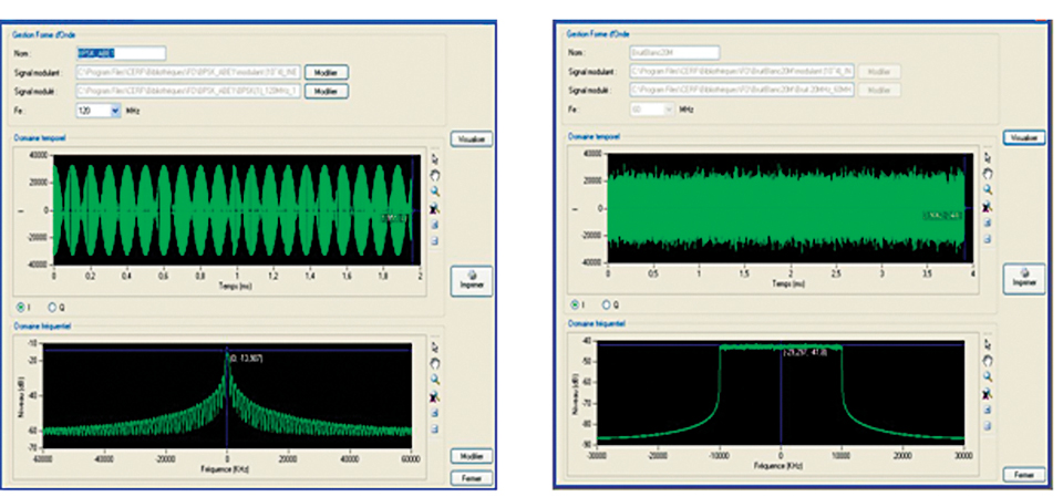
The center frequency of the jamming signals can be chosen anywhere in the bandwidth. Modulation examples: continuous wave, broadband noise, binary phase shift keying), binary offset carrier (x,y), and so on.
Figure 7. Modulation examples.
External software interfaces fall under three categories.
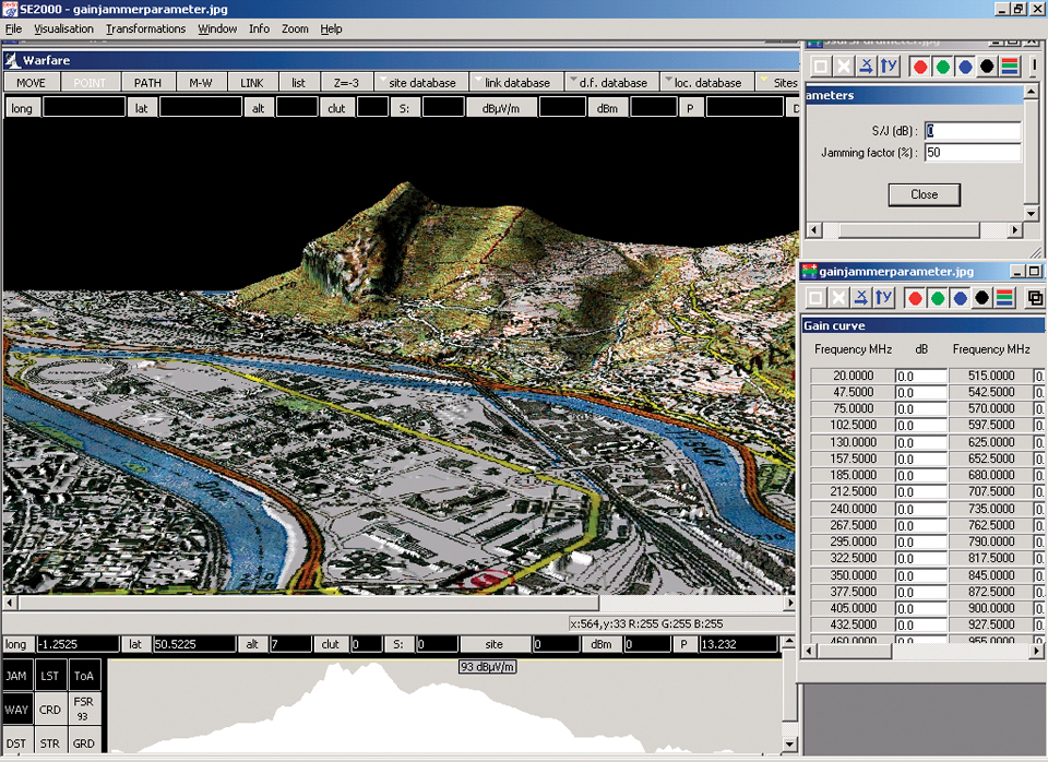
Warfare. Electronic warfare software, which provides jamming coverage, performs a precise assessment of propagation (reflection and diffraction) of the interfering signals (depending on terrain modeling). Interference levels are transmitted to SINERGHYS during pre-processing.
Figure 8. Warfare GUI.
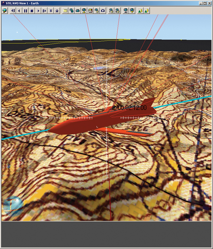
Satellite Tool Kit (STK). This software is designed to provide sophisticated modeling and visualization capabilities and performs functions critical to all mission types, including propagation of vehicles, and determination of visibility areas and times. STK generates paths for space and ground-based objects, such as satellites, ships, aircraft, and land vehicles. STK also provides animation capabilities and a two-dimensional map background for visualizing the path of these vehicles. Within SINERGHYS, STK is used for real-time visualization.
Figure 9. STK GUI.
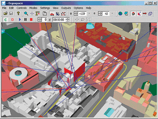
Ergospace. This software is designed to generate multipaths, enabling the modeling of reflected paths of different satellite signals on surfaces of realistic 3D scenes. Pre-processed multipaths are sent to SINERGHYS and generated by the GPS simulator. The software is also used for real-time visualization.
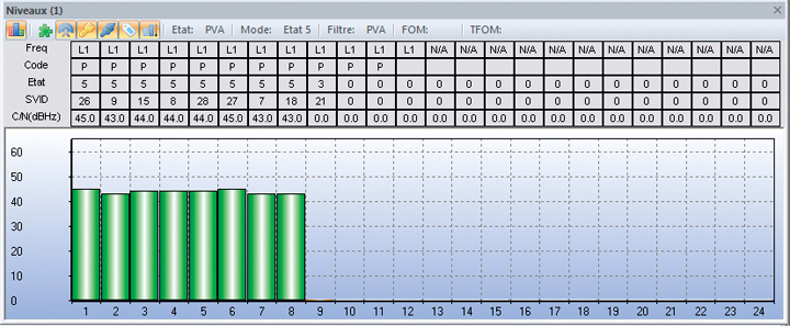
Figure 10. Ergospace GUI.Figure 11. Example of the window showing the general state of the GPS receiver (c/n, svid, gram receiver and channel states, code and frequency tracked).
Operational Mission Characterization
The bench can evaluate and characterize receiver performance in most possible representative conditions.
Management of GPS Inputs/Outputs. Both black and red keys can be loaded inside the GPS receivers in both DS101 and DS102 protocols. This loading can be performed manually through key loaders such as KYK13 or DTD/ANCYZ10, but also through the host application with hexadecimal keys.
The bench can send commands to GPS receivers such as non-volatile memory erasure command, INS, precise time source, precise time and time interval (PTTI) activation commands, or choices between “mixed mode” and “all Y,” between “L1 primary” and “L2 primary,” and so on. Depending on user requirements, the bench can provide time, position, speed, almanac, ephemeris, or specific navigation sub-frames.
To test the jamming resistance of GPS receivers, it is essential to be able to provide INS aiding. SINERGHYS uses perfect or degraded aiding and adapts the format or the frequency for the considered GPS receiver.
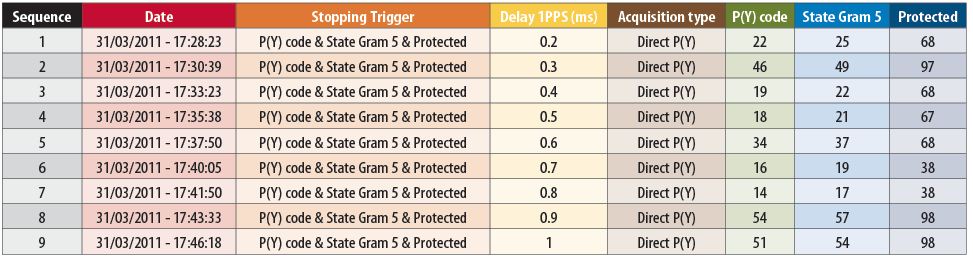
Direct P(Y) acquisition functionality is an important case that needs to be evaluated. The GPS receiver needs a precise time to perform direct P(Y) acquisition. The time accuracy, from a few nanoseconds to several milliseconds, has a strong impact on the GPS behavior. A special delay box applied to the pulse-per-second signal of the GPS simulator in accordance with PTTI message (that is, time figure of merit), enables such a simulated accuracy.
A standard IS 153-like interface was developed to display GPS data on a convenient GUI in order to have a common software to visualize output data from the GPS receivers. The user can also visualize some specific data from GPS ICDs concerning integrity, alarms, and cryptography.
All receiver output data are recorded for later analysis.
Table 1. Example of Direct P(Y) acquisitions in accordance with time uncertainty (with times to get “GRAM state 5” and “protected status”).
Monte Carlo Trials
The bench enables sequentially and automatically chaining scenarios (up to 10 000 test sequences) to perform statistics on acquisition times. Indeed, it is primarily used for the characterization of TTFF. GPS signal acquisition is dependent on many different parameters, as described in Figure 12. To properly characterize receiver acquisition times requires a large number of tests. The comparison with GPS Receiver Applications Module requirements can be easily performed.
Figure 12. Setup parameters to study GPS signal acquisition.Figure 13. Example of a random selection for the position error.
One Monte Carlo trial consists of a repetition of unitary test: powering the receiver, then sending to the GPS receiver random errors of position, speed, time, levels of jamming, and finally stopping the test sequence on trigger. At the end of Monte Carlo trials, statistical computing enables accurate analysis and expertises.
The random selections are optimized to reduce the number of cases. The bench can replay a particular case: as the seeds are deterministic, a special case of Monte Carlo method can be selected and replayed.
Real-Time INS/GPS Data Fusion
The information delivered by INS and GPS are processed by a Kalman filter. The INS trajectory is provided by the simulator or by an external file.
Two types of coupling are considered: loose coupling with position and velocity information, and tight coupling with pseudoranges and delta ranges to estimate errors. In both cases, the GPS receiver receives aiding from either the simulated INS or the optimal navigation (Kalman filter output).
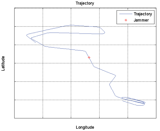
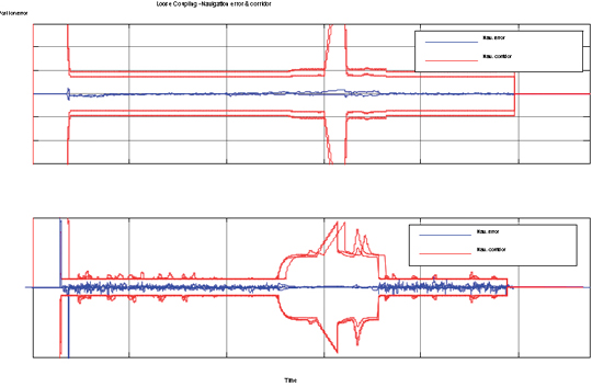
Figure 14. Example of an optimal navigation along a specified trajectory in a jamming environment.Figure 15. Position and velocity errors and navigation corridor.
The purpose of the Kalman filter is to estimate the navigation errors (position, velocity, and attitudes) and sensor errors (INS, GPS).
The filter design is original because it is independent from the receiver under test and from the type of application (hardiness privileged with reference to jamming). It is also able to estimate the time offset between position and velocity measurement on any GPS receiver under test.
Conclusion
SINERGHYS combines several resources into a single test bench. A complex mode can simulate an operational implementation with different interfaces and by chaining test sequences: receiver initialization, management of the switching of antenna patterns during a simulation, masking of GPS signals, management of jamming, INS/GPS data fusion, and so on. In this mode, missions can be replayed in a realistic environment. This bench is a complementary resource for flight trials and digital models because it can characterize the initialization phases with a good control of initial conditions. SINERGHYS enables users to know, as precisely as possible, the capabilities and limitations of a specific global navigation chain.
Manufacturers
SINERGHYS was developed by Bertin Technologies and specified by the French Ministry of Defense (MoD)DGA Information Superiority. It drives a Spirent GPS/Galileo simulator, Agilent 4431B and MXG generators, and software programs such as Analytical Graphics, Inc. (AGI) Satellite Tool Kit and Ergospace 3D scenes. The embedded jammer was developed by Ineo Defense in 2010 to MoD-DGA specifications.
Stéphane Gallot works at the French MoD (DGA Information Superiority) as a radionavigation expert. His particular interest is the integration of military GPS receivers including SAASM modules within French platforms.
Pascal Dutot is an architect engineer at the French MoD (DGA Information Superiority). His main activity is to optimize and control GPS integration in the global navigation chain.
Christophe Sajous works at the French MoD (DGA Information Superiority) as a radionavigation expert. He is also responsible for the “navigation per satellites” laboratory within the radionavigation department.