L3Harris Technologies has received a contract from the U.S. Space Force’s Space Systems Command to develop design concepts for Phase 0 of the Resilient Global Positioning System (R-GPS) program.
This initiative aims to enhance the existing GPS constellation by integrating cost-effective small satellites, providing increased resilience for both military and civilian users. The R-GPS program seeks to augment the current 31-satellite GPS constellation with up to eight additional satellites. The new satellites are designed to counter various threats, including jamming, spoofing and more, ensuring uninterrupted positioning, navigation and timing (PNT) services.
L3Harris has provided navigation technology for all U.S. GPS satellites launched to date. The company has also contributed to the development of control systems and monitoring receivers and user equipment for GPS. This experience serves as the basis for their proposed R-GPS solution.
L3Harris is leveraging its investments in transformational PNT technology to meet the Space Force’s evolving requirements by using commercial form factors and interfaces to create a modular, scalable solution, the company said. Additionally, L3Harris is collaborating with the Space Force as the prime contractor for the experimental Navigation Technology Satellite-3 program, which focuses on developing innovative technologies and accelerating development timelines.
VIAVI Solutions has signed an agreement to acquire Inertial Labs for $150 million. The acquisition, subject to certain regulatory approvals and customary closing conditions, is expected to close in the third quarter of fiscal 2025 and has a potential for up to $175 million in contingent payments throughout the next four years.
This acquisition is expected to significantly boost VIAVI’s financial performance, with projections indicating an increase of approximately $50 million to the company’s Network and Service Enablement (NSE) annual revenue in 2025. Inertial Labs brings to VIAVI a comprehensive portfolio, including inertial measurement units (IMU), inertial navigation systems (INS), assured positioning navigation and timing (APNT), GNSS tracking, lidar scanning, alternative navigation (ALTNAV) and visual navigation solutions. These offerings complement VIAVI’s existing PNT and other aerospace and defense solutions.
According to VIAVI Solutions, the acquisition is designed to open up new opportunities for VIAVI in emerging markets. Inertial Labs’ expertise in utility inspection through lidar and photogrammetry algorithms, as well as smart system navigation for airborne and autonomous ground vehicles, is expected to accelerate VIAVI’s entry into industrial and autonomous delivery and transportation end markets.
“With a highly complementary product portfolio focused on alternate navigation solutions, this transaction supports VIAVI’s strategy to expand our presence in domestic and international aerospace and defense segments and accelerates our entry into autonomous air, land and sea systems in the military and industrial end markets,” said Oleg Khaykin, president and CEO of VIAVI.
“We are excited that our expertise, precision solutions and resources provide expansion opportunities for VIAVI in high growth markets and applications such as drone-based lidar and camera systems,” said Jamie Marraccini, president and CEO of Inertial Labs.
Skykraft, an Australian space technology company, has signed a participating project partner agreement to advance positioning, navigation and timing (PNT) systems in low-Earth orbit (LEO). This agreement, backed by an International Space Investment (ISI) India Projects grant from the Australian Government, marks a significant milestone in fostering space cooperation between Australia and India.
The project’s primary objective is to develop and demonstrate collaborative PNT systems. This includes establishing the viability of large-scale LEO constellations, addressing vulnerabilities in existing GNSS in denied environments, and exploring novel applications for PNT signals from LEO. Additionally, the project aims to create a comprehensive roadmap for collaborative LEO-PNT by implementing resilient, easily updatable constellations.
The project also seeks to enhance environmental monitoring capabilities through GNSS-reflectometry (GNSS-R) and radio occultation (GNSS-RO) technologies. This will improve understanding of Earth’s oceans, droughts, and floods while enhancing real-time space and terrestrial weather forecasting. It will explore emerging applications, such as tsunami monitoring and warning systems.
Among them was a funding increase for the National Physical Laboratory’s National Time Centre (NTC) project, from £30 million to £62.7 million, and a plan to have NTC and the first of the nation’s new eLoran towers at initial operating capability by January of 2027.
Plans for all efforts beyond next year were necessarily caveated with “subject to spending review.”
Still, seminar attendees were gratified to hear the minister endorse the ten-point PNT policy framework published by the previous administration in 2023. It was particularly encouraging that he also committed to operationalizing it with implemented systems.
The minister did not mention the UK’s significant investment in quantum research, which was discussed later in the seminar. This research has the potential to contribute to PNT with better timekeeping and inertial and gravimetric sensing. Three quantum hubs — one each in Scotland, the Midlands and the South — are part of this effort.
Lord Vallance, UK Science Minister. (Image: 10 Dowing Street)
Lord Vallance and Shabana Haque, Ph.D., the head of the National PNT Office, who spoke later, also mentioned two important non-technology themes.
The first theme was that the PNT office is fully funded, staffed and very active. It was created last year as a cross-government effort and included representation from the Ministry of Defence. In addition to pushing the nation’s PNT efforts forward, the office has been engaged with numerous other governments, including those of the United States, Canada, Australia, New Zealand, Europe, Japan and Korea.
Secondly, the PNT initiatives are necessary for the nation’s resilience and security but will also be a source of economic benefits. This goes beyond PNT resilience, enabling Britain’s economy to function during local and potentially widespread GNSS disruption events. As the nation develops the technology stack to support its own resilient PNT architecture, along with enabling and supporting policies, devices and services will become marketable to others.
Shabana Haque, Ph.D., head of the UK PNT Office, spoke to the RIN at its 2024 UK PNT Leadership Seminar. (Image: RIN)
A sovereign PNT capability that can both stand independently and cooperate with GNSS is becoming increasingly attractive to many nations. Being able to source such a capability from a respected and trusted ally such as Great Britain could make acquiring and implementing such a system much easier for many.
The UK government has been working with several partners to advance its understanding and planning implementation of an eLoran capability. Haque highlighted work with the ESA’s F)!NAVISP program, resulting in the UK’s Roke developing an eLoran antenna for handheld devices. She also discussed the integration of the National Timing Centre’s clock and fiber network with eLoran signals and the development of GNSS/eLoran receivers. Of particular interest to many was an “eLoran Effectiveness Report” that the government commissioned and received from the General Lighthouse Authority’s Research and Development (GRAD) team. GRAD has had extensive experience with the technology, having operated and evaluated a differential eLoran system along Britain’s east coast for more than a year.
In a related move that helped signal the UK’s commitment to the technology, the Ministry of Defence issued a request for information (RFI) about a deployable eLoran capability in September. The RFI indicated that the document was a prelude to an acquisition.
The UK Science Minister also praised the RIN’s work and publication of a series of tools to help explain PNT and the need for resilience to those outside the community. The tools will also help organizations evaluate their readiness for GNSS disruptions.
A PNT Resilience Checklist for organizations to use to self-evaluate their risk from GNSS disruptions.
The RIN recommends that PNT experts use these tools to work with customers, suppliers and partners and act as a “guiding hand.”
The RIN sees these all as a “phase 1 release.” Feedback on the tools is encouraged and should be sent to [email protected] The RIN team say they are eager to know what works, what could be improved, and to receive suggestions for other efforts.
As a “learned society,” the RIN has a significant influence on government policy and direction. Lord Vallance recognized this, saying that “the Royal Institute has played a really important role in recent years to highlight the PNT opportunity and risk, to provide expertise, and to work with government on solutions.”
The RIN’s director, John Pottle, and RIN Fellows Ramsey Faragher, Guy Buesnel and Andy Proctor were all recognized during the seminar for their contributions to the organization’s resilient PNT efforts.
Commercial eLoran to be offered in the UK
Hellen Systems, Inc. and Arqiva have partnered to develop a commercial eLoran service in the United Kingdom. The announcement was made on the Hellen Systems LinkedIn page.
The partners seek to support critical national infrastructure, government, and military users by citing the need for “sovereign, independent, resilient” PNT alternatives.
eLoran is deployed and operating across China and South Korea. Older versions of Loran are operating in Russia and Saudi Arabia. Yet, aside from a single transmitter in the UK being used as a timing signal, operating Loran systems have been off the air in the West since the European system shut down in deference to Galileo in 2016.
In recent years, increasing interference with GNSS signals has rekindled Western interest in the technology. The European Space Agency (ESA) recently sponsored a project that produced an eLoran antenna suitable for mobile devices. Three transmitters are on-air in the U.S., presumably for testing, and the UK Ministry of Defence has issued a request for information, which is expected to lead to the purchase of a deployable eLoran system (the U.S. Air Force operated a deployable capability called Loran-D in the 1970s).
Originally developed and used in World War II, some still view Loran as old technology. Its advocates counter that today’s telephones and televisions are vastly improved over 1940s technology, and the same is true for eLoran over its older Loran-A and Loran-C versions.
A high-power terrestrial system operating at 100kHz, UK demonstrations with differential eLoran in 2014 showed an accuracy of 10 m positioning and 50 ns timing. The positioning accuracy for the previous version of Loran, Loran-C, was approximately 460 m absolute accuracy, 90 m repeatable accuracy and 5 µs.
Hellen Systems’ President, Bridge Littleton, says the partnership is “… excited to bring commercial eLoran to the UK as a unique resilient PNT capability” and cites its advantages as a secure signal able to penetrate deep indoors without the need for an external antenna. The UK frequency regulator, Ofcom, proposed offering commercial eLoran licenses in 2022 and began the process in 2023. Hellen was granted a UK spectrum license for eLoran earlier this year.
The announcement also lists Microchip, Chronos Technology, Ltd, Continental Electronics, and CGI as team members in the project.
Advanced Navigation and MBDA have partnered to co-develop a resilient navigation system that incorporates MBDA‘s NILEQ absolute positioning technology.
The collaboration aims to provide robust absolute positioning for a variety of airborne platforms, enhancing navigation reliability in both civilian and military sectors. The joint effort is part of a broader initiative to boost research and technology development between the United Kingdom and Australia, aligning with the objectives of AUKUS Pillar 2 — a component of the security partnership between Australia, the UK and the U.S. in September 2021. The partnership includes informed decision-making, strategic autonomy and heightened combat efficiency in the face of emerging threats.
This partnership underscores the importance of developing navigation technologies that are resilient against interference, especially in an era marked by increasing geopolitical tensions and electronic warfare threats such as GPS jamming and spoofing.
NILEQ technology utilizes neuromorphic sensors to identify and compare terrain fingerprints, taking inspiration from biological change detection processes. This sensing technology captures data on changing terrain as an airborne system flies over it, matching this data to an existing database of the Earth’s surface. As a result, systems such as UAVs can achieve a precise position fix on land using a passive solution that is resistant to interference, which enhances the safety of beyond visual line of sight (BVLOS) operations.
The collaboration will conclude with a real-world demonstration of the NILEQ technology in Australia, validating its effectiveness in delivering resilient navigation solutions.
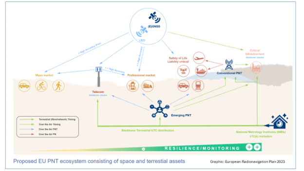
Citing a need for better “positioning, navigation and timing (PNT) resilience, availability and continuity,” a market consultation document from the EU’s Joint Research Center (JRC) says establishing a resilient PNT ecosystem is essential for “…EU autonomy, the economy’s overall resilience and EU global standing.” Therefore, creating this system-of-system ecosystem “… should be considered a critical priority for the EU.”
According to the JRC, complementary (or continuous) PNT, or C-PNT, is the combination of existing space assets (GNSS) and future services that can work together in the multi-system ecosystem. This extends the service to areas where GNSS is not available and increases overall resilience.
The JRC document goes on to say, “The first step towards the creation of such a C-PNT ecosystem is the deployment of the terrestrial timing backbone.”
Such a backbone would:
Interconnect existing Member States (MS) National Metrological Institutes (NMI) and National Research and Education Networks (NREN) architectures into a pan-European network.
Maintain and (if possible) enhance the existing use cases (NMI, NREN and their existing commercial customers) and enable time connections to critical entities (CE), as regulated by the directive on the resilience of critical entities, while also promoting GNSS for additional resilience.
Enable the commercial utilization of timing backbone to enhance EU competitiveness and enable further growth.
Responsibility for navigation issues with the European Union is somewhat dispersed. The European Radio Navigation Plan is developed as a staff working document published by the European Commission’s Director General for Defense, Industry and Space (DG DEIFS). This directorate implements the EU Space Programme, which is, in turn, managed by EUSPA, an EU executive agency.
At the same time the European Space Agency’s Navigation Directorate is responsible for “…positioning, navigation, and timing services of the European satellite navigation system Galileo and the augmentation system EGNOS” under agreement with EC. It is also responsible for ”…exploring future applications of navigation technologies for science and daily life.”
This latter includes the Navigation Innovation and Support Program (NAVISP). And while space is an important consideration in NAVISP, the program has funded some decidedly non-space projects such as the UK’s MarRINav effort which focused on terrestrial PNT, and development of an eLoran antenna for handheld devices.
The Joint Research Center supports a wide range of EU stakeholders for PNT efforts including DG DEFIS, ESA, member states, and pan-European organizations.
A “market consultation” may not seem to many as an affirmative step toward establishing a timing backbone for Europe. Experienced observers, though, point to the wealth of documentation both ESA and DG DEFIS have produced on the need for PNT resilience and the benefits that will accrue to member nations.
“The EU is very consultation and consensus-driven,” says timing expert Magnus Danielson at Net Insight. “So, you are not going to see the kind of top-down orders to do things as you might for a single state. Some of these decisions are made by each member state, as they should be. I am sure (European) Commission and ESA officials have seen what Sweden has done with distributed timing clocks operated by Netnoed, what the U.K. NPL is doing with its clock network, and are concerned about Russian jamming and spoofing in Ukraine and the Baltic. It’s pretty easy to connect the dots and make reinforcing PNT for Europe’s critical infrastructure and applications a priority. Working with the EC-JRC to develop this has been rewarding. Here’s hoping they move quickly enough. Several member states and friendly neighbors have already responded positively, and I sure the market consultation feedback will aid in moving decisions forward.”
The concept of a system-of-systems approach to resilient PNT that is underpinned by network timing is not a new one. The 2008 U. S. National PNT Architecture articulated such an approach, though it was never implemented. In 2020 the RNT Foundation expanded on this idea in a paper advocating a U.S. national resilient timing architecture using signals from space, fiber, and terrestrial broadcast. China’s National Timing Service Center adopted a similar strategy. Media reports indicate China has completed or will soon complete its High Accuracy, Ground-based Timing System with 20,000km of fiber, 295 timing stations, and nation-wide eLoran service.
The EU is asking for input about a European Timing Backbone and is interested in hearing from anyone, whether or not they are EU citizens.*
Xona Space Systems has partnered with QASCOM to integrate Xona PULSAR into QASCOM’s GNSS software-defined radio (SDR), the QN400-P. The integration is designed to strengthen positioning, navigation and timing (PNT) resiliency in the face of persistent threats.
The partnership seeks to deliver security, jamming and spoofing resistance and next-gen accuracy for industries such as UAV navigation and defense.
The QN400-P receiver offers multi-frequency, multi-constellation GNSS capabilities, including GPS and Galileo. Additionally, it includes measures for the mitigation of jamming and spoofing and is compatible with low-Earth orbit (LEO) PNT services, such as Xona’s PULSAR.
The demand for more robust, secure and accurate navigation is increasing across various industries, including agriculture, construction and autonomous systems. The integration of Xona and QASCOM technologies aims to deliver solutions for these sectors, as well as for other relevant applications and use cases.
Aerodata AG has been granted a Supplemental Type Certificate (STC) by the European Union Aviation Safety Agency (EASA) for its advanced GPS anti-jamming and anti-spoofing solution. The certification applies to installations integrated with Garmin 5000 avionics in a Cessna Citation Latitude jet.
With the growing threat of GPS jamming and spoofing in both civil and military aviation, Aerodata has developed a robust solution to offer continuous GPS availability. As attacks on GPS systems continue to increase, this anti-jamming and anti-spoofing technology is crucial in maintaining safe and reliable aviation operations.
Aerodata’s solution seeks to enhance its special mission capabilities, especially in Intelligence, Surveillance and Reconnaissance (ISR) missions and flight inspection, where continuous, highly accurate navigation is crucial.
Aerodata’s GPS Anti-Jamming and Spoofing Solution also positions Aerodata to reduce the vulnerability of its unmanned solutions to GPS interference, ensuring operational integrity across a wide range of manned and unmanned platforms. The newly certified system has undergone comprehensive testing and validation, and Aerodata is working on extending its capabilities to other aircraft platforms, targeting both civil and military applications.
Astranis has been selected as one of four prime contractors for the U.S. Space Force (USSF) Space Systems Command’s (SSC) new Resilient GPS (R-GPS) program. This initiative aims to augment the existing GPS constellation with small, low-cost satellites to enhance resilience for both military and civil users. The program’s initial phase, Lite Evolving Augmented Proliferation (LEAP), aims to launch up to eight satellites by 2028.
As part of this effort, Astranis has been awarded an $8 million contract for concept development. The company plans to leverage its expertise in manufacturing and operating low-cost, high-orbit satellites. Specifically, Astranis will utilize its MicroGEO satellite design and Octane Software-Defined Radio hardware to advance the R-GPS spacecraft design.
The R-GPS program is characterized by a rapid development timeline. It utilizes the “Quick Start” authority, which allows for contract awards in under six months. Ultimately, the USSF envisions a proliferated fleet of over 20 small GPS satellites to enhance navigation and timing capabilities.
These satellites will incorporate the latest GPS signals, including M-code, to offer optimal performance even in contested environments. In addition to Astranis, other contractors involved in the initial phase include Axient, L3Harris and Sierra Space.
The Royal Navy has successfully tested a new quantum sensing technology designed for underwater detection. Conducted off the coast of Plymouth aboard HMS Magpie, the trials aimed to evaluate the effectiveness of this quantum-sensing system in identifying submerged objects.
The technology leverages ultra-cold atoms to measure subtle variations in the Earth’s magnetic field, which indicate underwater objects. This method allows for the detection of items that traditional sonar systems might miss, enhancing the precision of underwater surveys.
During the tests, the system identified various targets, including a concrete block weighing one ton, and demonstrated sensitivity sufficient enough to detect objects as small as a soccer ball.
This project is part of a broader collaboration involving the Royal Navy, the Defense Science and Technology Laboratory (Dstl) and industry partners. It reflects ongoing efforts to integrate advanced technologies into naval operations, aligning with the UK’s strategic focus on quantum technologies.
Future plans include further development and miniaturization of the quantum sensing system to enable its deployment on various naval platforms, such as ships and submarines, as well as autonomous underwater vehicles. The successful trials indicate that this technology could significantly improve the Royal Navy’s capabilities in maritime security and underwater exploration.
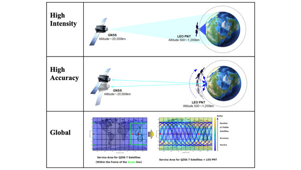
The Japan Aerospace Exploration Agency (JAXA) has awarded Japanese startup ArkEdge Space a contract to study the feasibility of establishing a constellation of positioning, navigation and timing (PNT) satellites in low-Earth orbit. The project aims to provide high-precision PNT signals across the globe.
Government agencies worldwide are exploring ways to complement and back up GNSS, which is susceptible to natural and deliberate interference. In addition, self-driving cars and autonomous drones require extremely precise location data.
Under the new JAXA contract, ArkEdge Space will provide a conceptual design for a LEO-PNT satellite and its orbit. ArkEdge will also explore satellite and constellation tradeoffs and consider different signal formats and frequency bands.
With a new LEO-PNT constellation, JAXA seeks to expand the coverage area of service currently provided by Japan’s geostationary Quasi-Zenith Satellite System (QZSS) satellites.
Under a separate JAXA contract, ArkEdge is developing positioning and communications services for cislunar space.
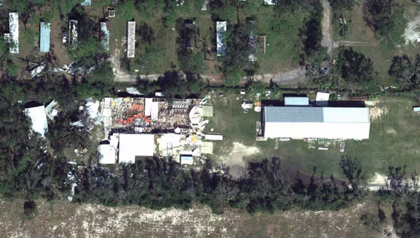
Hurricane Helene has caused widespread devastation across the southeastern United States, leaving a trail of destruction more than 500 miles long from Florida to the Carolinas. The storm made landfall at the Big Bend of Florida, on Sept. 26, 2024, as a Category 4 hurricane with sustained winds of 140 mph.
The death toll has risen to at least 215 across six states, with hundreds more still unaccounted for, reported ABC News. More than 4.5 million people initially lost power due to the hurricane, with more than two million residents still without electricity days after the storm. Utility companies face significant challenges in restoring power due to blocked and damaged roads. The storm’s destruction has rendered many essential roads and bridges impassable, complicating recovery efforts.
Role of GNSS in Recovery
GNSS plays a crucial role in disaster recovery operations. These systems provide essential positioning, navigation and timing (PNT) services critical for search and rescue efforts such as flood monitoring. GNSS technology enhances emergency services by enabling synchronized communication networks, providing precise location information and allowing for faster response times. With cell towers and electrical services down, GNSS empowers virtually all disaster recovery efforts.
Over the years, our reliance on GNSS has increased into an aspect of life we often overlook. Its importance is emphasized in times of disaster, PNT is critical.
A recent public safety announcement issued by the Space Force highlights that a critical component of any successful rescue operation is time. Knowing the precise location of landmarks, streets, buildings, emergency service resources and disaster relief sites reduces the time it takes to navigate challenging terrains to save lives. This information is critical to disaster relief teams and public safety personnel in order to protect life and reduce property loss. GPS serves as the fundamental technology in addressing these needs.
The United States Geological Survey (USGS) is also collecting flood data and repairing damaged streamgages to monitor water levels after Hurricane Helene.
USGS Mapping the Aftermath
As of Oct. 7, USGS provisional streamgage data indicates that at least 34 new flood records were set across the southeast from flooding caused by Helene. Eighteen of these provisional records were set in North Carolina, with six in Tennessee, six in South Carolina, three in Florida and one in Georgia.
In Newport, Tennessee, USGS field crews were able to measure high-water marks left behind by flood waters and determined the Pigeon River reached a provisional peak water level of 29.72 ft. The previous record on this river was 21.40 ft, set in 1902.
As communities begin the long process of rebuilding, they face numerous challenges, including limited resources, prolonged power outages and disrupted communication systems. However, GPS serves as a backbone in the recovery process, highlighting its significance in times of disaster. The full extent of Hurricane Helene’s impact is still being assessed, with authorities warning the death toll may continue to rise as search and rescue efforts progress.