onocoy has launched the onocoy real-time kinematic (RTK) service designed to offer positioning capabilities worldwide.
The service utilizes blockchain technology and a decentralized network of reference stations, offering users accurate correction data for applications requiring centimeter-level positioning. onocoy RTK offers global coverage with data quality controls in place to verify correction information before distribution.
According to onocoy, the service offers quick convergence times and high accuracy due to its dense network of reference stations. It outputs data in the standardized RTCM format for integration with various systems.
onocoy RTk targets industries such as agriculture, construction, mining, robotics and autonomous systems that require flexible and reliable high-precision positioning. onocoy says it is also developing business-to-business offerings, including access to station data and customized solutions.
With this launch, onocoy aims to expand access to RTK technology and advance high-precision positioning capabilities across sectors.
In June, the Navigation Innovation and Support Program (NAVISP) Advisory Committee (NAVAC) of the European Space Agency (ESA) issued a paper titled PNT Vision 2035. It provides an interesting overview of the state of positioning, navigation and timing (PNT) and where it will be a decade from now.
According to ESA’s website, key findings in the paper include:
Increasing Dependence on PNT Services – particularly for consumer and autonomous solutions. Accurate timing remains a critical use case, especially in telecom and power distribution.
Geopolitical and Technological Challenges: Rising cyber-attacks, jamming and spoofing, advancements in AI, ML and quantum computing will have significant impacts. Anticipate new regulations.
Technological Trends Driving PNT Demand: The proliferation of connected devices (IoT), autonomous driving, advanced air mobility, smart grids and autonomous vehicles will drive the demand for resilient and robust PNT.
System Architecture Evolution: Future PNT systems will utilize a combination of data sources, including multiple GNSS constellations, cellular networks (5G/6G), terrestrial systems, augmentation systems, and autonomous sensors. This “system of systems” approach will enhance performance and ensure independence from single points of failure.
Emerging Technologies and Sensor Integration: Advances in space segment technologies, receiver designs and sensor integration, new signal designs, flexible payloads, advanced clocks, inter-satellite links, and higher power amplifiers are highlighted.
Luis Mayo
We spoke with Luis Mayo, NAVAC’s chair, to get his take on this seminal work.
Question: To set the stage, what is NAVAC?
Luis Mayo: NAVAC is a group of external PNT experts that ESA has assembled to provide independent advice on navigation issues, and especially for NAVISP.
Q: Where can NAVAC’s formal recommendations be found?
Mayo: We perform an assessment of the NAVISP status every two years. We provide our recommendations as a conclusion of this assessment. Beyond that, our formal recommendations are collected in documents like this white paper or in proposals for modifications or adjustments to the work plans of the programs.
Q: How does ESA leadership generally view and react to NAVAC conclusions and recommendations? Does it act upon every recommendation?
Mayo: They are generally receptive. However, we are just an advisory body, so it is up to them to take on our recommendations. They often do so and use our advice to add weight to their proposal to the Navigation Programme Board, but they do not necessarily have to.
Q: PNT Vision 2035 is a substantial document. Clearly it involved some time and effort. Why was it written? Is it something ESA requested?
Mayo: The paper was the initiative of NAVAC members to inform the ESA Ministerial Conference in 2025. These conferences take place every three years to define the roadmap for the next period. New European space programmes, extensions or redirections of existing ones, and budgets are approved at these meetings.
Q: We thought we might make a modest contribution to the definition of the future ESA navigation programmes. What, if anything, did NAVAC find surprising or unexpected about findings included in the Vision?
Mayo: I would say that we hardly found anything too unexpected or surprising. The findings are the conclusion of multiple discussions on the subject over the past few years. We have just expressed them in a more articulated way.
If anything, and from my personal perspective, I would like to highlight that this exercise helped me realize that the deployment of some of the most exciting or expected applications of PNT technologies — such as autonomous driving — depend on the development and deployment of multiple other technologies that might not be necessarily available in the mid-term.
AVAC’s first meeting in 2018. From left to right: Javier Benedicto, ESA Navigation Director, and NAVAC members Alessandra Fiumara, Peter Grognard, Giorgio Solari, Rafael Lucas Rodriguez, Pierluigi Mancini, Roger McKinlay, Stefano Debei, Nityaporn Sirikan, Bernd Eissfeller and Luis Mayo. (Photo: ESA)
Q: What are the three most important things policymakers should understand from the document?
Mayo: First is that many infrastructures or services critical to the daily lives of the citizens are dependent on PNT technology.
Second, they cannot take for granted that GPS or Galileo services will be always available, not to mention GLONASS or BeiDou. Satellite navigation systems are vulnerable and are continuously under threat. Enabling assured PNT service is a must.
And third, there is more to PNT than satellite navigation. Other complementary or alternative technologies should not be abandoned. In fact, some of those technologies might even change the way in which we have traditionally conceived satellite-based navigation.
Q: What are the most important things policymakers should do to enable the PNT needed by 2035?
Mayo: I think they have to sustain the existing satellite-based navigation systems and foster the development of new technologies and systems that improve the robustness of the services. We have done a lot so far to provide PNT services globally. When you come to think of that, it’s really wonderful what we have achieved this far. We cannot afford to lose what we have, but that has proven not to be enough. Therefore, policymakers should keep helping the development of new technologies and services that complement what we have, improve the quality of the services and ensure its continuous availability and integrity.
They should also look beyond the current service volume. Spacefaring nations should be aware of the fact that they will need this kind of technology to support future missions. Deploying systems able to provide PNT services beyond the coverage of the current GNSS is an absolute necessity to support such missions.
Q: The vision says the EU must consider no longer having access to GLONASS and BeiDou. There are a number of threats that are common to all GNSS. Why not consider loss of access to all either temporarily or permanently?
Mayo: We have not considered a completely catastrophic situation such as losing access to all GNSS in our vision. We understand that GPS, Galileo and eventually other constellations or augmentation systems will remain available and provide at least partial coverage for PNT services.
Q: The vision makes recommendations about mitigating interference, using AI and extending the GNSS service volume. What else should policy and technology decision-makers take from the document and act upon?
Mayo: We must not forget there is a clear case for investing in future PNT systems. ESA should keep up to pace with foreign competitors that seem ready to increase their expenditure in these types of problems.
They also have to be conscious that satellite-based navigation is not enough. We have to look for alternative and complementary systems to reach the level of confidence that we need on PNT solutions.
Q: Perhaps you are thinking of all the PNT systems China has deployed?
Mayo: I am really thinking about what we are not doing in Europe or in the United States. We need to build alternatives that might not have global coverage but would allow us to maintain essential PNT services running at home.
Q: Resilience seems to be an important theme in the document, but it was not the subject of a specific recommendation. Could you speak to that?
Mayo: Resilience is a pervasive theme throughout the whole document. This is a major concern. We have to find a way to build a system of systems that can deliver to the user a trustworthy PNT solution at any time.
Resilience is, today, a key consideration in PNT, and we cannot do anything but acknowledge this fact. We might not have insisted enough on the importance of this feature for future PNT systems, but policymakers must undertake any actions required to improve the resilience of the existing PNT systems and services, probably by promoting the development of alternative independent PNT systems.
Q: What else should GPS World readers know about the Vision?
Mayo: Read the document. It is not that long. Also, think that it has been written from an independent and experienced standpoint. We at NAVAC do not pretend to hold the full truth, but I believe that we have a quite comprehensive view of the matter and that this would be useful for the reader.
The U.S. Army has released a Request for White Papers (RfWP) to develop new C5ISR modular open Suite of standards (CMOSS) mounted form factor (CMFF) prototypes.
Through CMFF, the Army aims to easily and rapidly equip ground vehicles and aviation platforms with positioning, navigation and timing (PNT) and electronic warfare (EW), through capability cards plugged into a common chassis.
The chassis, which offers power, networks and radio frequency, allows Soldiers to “plug and play” capabilities right into the vehicle without the need to custom install and upgrade individual communication and computing systems.
In this prototype effort, the key needs are to develop, procure and furnish the Army with the CMFF chassis, also known as Mounted Common Infrastructure (MCI), plus the smart display for user interface, hardware development, software development and Plug-In Cards with the following capabilities:
Converging tactical communication waveforms.
Mission Command applications.
Assured Positioning, Navigation, and Timing (APNT.)
Force Protection capabilities.
The Army plans to award a contract using the Other Transaction Authority (OTA) with system of system and prototype integrators to provide the complete CMFF system offerings. Industry partners who respond to the RfWP will have an opportunity to showcase the fully functional CMFF system at a technology demonstration in late summer 2024.
“The power of the true concept is when you can take a chassis and put it in another vehicle and you can mix and match cards,” said Col. Shermoan Daiyaan, project manager for Mission Command. “That’s when you’re following a standard. You’re matching a standard, and it just works.”
The European Defense Fund (EDF) and the Ministries of Defense of Estonia and Finland have awarded a $6 million investment to Project BadB, a consortium led by KrattWorks, an Estonian defense technology company. The project focuses on developing advanced navigation solutions for land and aerial vehicles that operate independently of GNSS.
Project BadB aims to address the challenges posed by rapidly evolving electronic warfare technologies, such as radio jamming and GNSS spoofing. The project seeks to ensure reliable navigation for unmanned systems operating in contested environments, enhancing their operational effectiveness in active war zones and other critical areas.
Specific objectives of the project include the development of weather-independent up-to-date satellite imagery maps for unmanned aerial and ground vehicles, a machine vision module, an image recognition system and a path planning system, based on sensor data, cross-platform data sharing and swarming.
GIM Robotics will develop GNSS-denied navigation software for land vehicles, designed to resist and detect jamming and spoofing so vehicles can navigate accurately — even when GNSS signals are unavailable. The company’s technology allows land vehicles to maintain precise navigation using alternative data sources, such as satellite imagery and sensor integration.
According to EDF, the project has gained attention among European defense and innovation leaders, who see it as solving a burning issue for the rapidly growing unmanned systems sector. The situation on the technology front has changed significantly in the past two years, as the sector faces new obstacles and opportunities each day.
“We are witnessing an unprecedented fundamental change in the character of war, and our window of opportunity to ensure that we maintain an enduring competitive advantage is closing,” said General (ret) Mark Milley.
GNSS-free navigation and geolocation also possess potential for civic use – such as in applications for critical infrastructure management, natural disaster mitigation and autonomous transportation systems.
Project BadB was selected during the EDF 2023 Calls for Proposals, with a project duration of 24 months. The EDF aims to boost cooperation between companies and research entities to enhance European defense capabilities.
Satelles, which developed the Satellite Time and Location (STL) system, recently became part of Iridium, which already owned a large share of the company. I spoke with Michael O’Connor, previously Satelles’ CEO, who is now Executive Vice President of Iridium’s PNT Division.
Besides the ownership change, has anything changed in your organization?
What was the Satelles business is now part of the broader Iridium company. We’ve been partnered very closely with Iridium since the genesis of Satelles more than a decade ago. It really made strategic sense to become a part of Iridium. The industry is clearly at an inflection point. We don’t have to look too far to understand that the mainstream is catching on to the things that you have been writing about for years. Now, people are realizing what’s actually happening. Various users — especially those near conflict areas — are starting to truly experience jamming and spoofing events. The world is starting to recognize that there’s a need for solutions. The U.S. Department of Transportation has just come out with a complementary PNT plan. They put out a request for a quotation recently to engage the industry.
Companies like ours, and others in the industry who have been developing solutions to this problem for many years, will finally start to see traction with customers. We just signed an agreement with L3 Harris to roll out GNSS augmentation or complementary PNT for the Federal Aviation Administration (FAA) to networks. Not just industry, but also the U.S. government is now taking steps to implement the resilience that’s needed to protect critical infrastructure. So, the timing is good.
Does being now fully part of Iridium give you any additional access to the company’s satellite network?
We will be rolling out, over time, some additional capabilities and expanded service areas. We will be announcing ways in which, by integrating the companies, we can expand more quickly into new geographic areas, providing additional signal coverage in areas where Satelles had not previously been able to do so. As Satelles, we were very focused on timing and national critical infrastructure. Iridium’s business lines align with some of the directions in which Satelles was already intending to grow in any case — such as maritime, internet of things (IoT) and possibly even someday aviation. There are areas where we will be able to expand our reach much more quickly than we ever would have been able to do as a standalone company.
STL makes indoor positioning possible because the signal is much stronger due to Iridium’s satellites’ much lower orbit than that of GPS satellites, correct?
Exactly right. It’s really about the signal power. Part of it is being closer to Earth, part of it is that we are on a channel that was dedicated to paging, back when people had pagers on their belts and was designed with a higher power signal than the Iridium satellites’ two-way voice and data channels. Additionally, we’ve designed the signal itself to also have some coding gain. So, all those things ultimately increase the receive sensitivity of a receiver by about 30 dB, which makes the signal 1,000 times stronger.
In the mix of complementary PNT options and systems, what are your system’s strengths?
There is no single silver bullet solution to complementary PNT. We can offer our solution, but different applications have different needs, for sure. What Iridium offers with the Iridium STL service is a system that’s available today to protect critical infrastructure — we’ve been delivering this to customers, we have thousands of users; it’s available globally — we effectively have a global license, a global capability, a global satellite constellation. We also have the distinct advantage of a high-power signal that can reach places where GNSS cannot. So, we focus on applications for which we can offer some unique value. A lot of that is based on the underlying Iridium satellite network. A long time ago, Iridium secured global rights for the L-band spectrum. Besides being in LEO, the network has inter-satellite links that enable it to cover the whole world from a finite, manageable set of ground monitoring sites.
Because of all these aspects of its network, Iridium can offer something unique in the industry. Other solutions have different advantages and disadvantages. There is a breadth of solutions across the industry. All these entities are trying to solve the same important problem. Different users of PNT and different users who have a need for complementary PNT will see the advantages and disadvantages of different solutions out there. So, we like that there’s a thriving ecosystem of solution providers.
Iridium Communications will provide its Satellite Time and Location (STL) service to more than three dozen L3Harris-operated communications network backbone nodes and a similar number of Federal Aviation Administration (FAA) facilities throughout the United States. (Image: Iridium)
Regarding markets, end users and user applications, what’s your focus?
Our focus today is very much around timing and national critical infrastructure. We are in that market today, but it is one where we also see the greatest growth. We already have several partners who are selling products into those markets — including Adtran Oscilloquartz, VIAVI and Safran — and products available today. That market is just starting to recognize the need for complementary PNT and accelerate its adoption.
Our primary focus today is making those customers successful with our solutions. Looking at new market opportunities, we are exploring the next products and markets we will pursue, but it is likely to be in an area that overlaps with those in which Iridium already has great partners and customers to which we can provide additional value. Maritime is a good example. Aviation may be a longer sales cycle. It would be speculating as to what that next big market will be because right now we are very focused on that initial market.
As far as timing for critical infrastructure — cell phone towers, electrical distribution, data centers, etc. — are your boxes replacing the previous ones or sitting next to them?
They can do either. The products that our partners offer include GNSS plus STL, so it can replace the GNSS-only solution in those systems. A lot depends on the customer and the application, of course. Our partner would provide a solution that includes GNSS plus STL; it typically would replace a GNSS-only solution and provide resilience by having a complementary PNT capability.
The solutions we’re providing to the FAA are not on-aircraft solutions. They are ground infrastructure solutions that keep the integrity of the ground networks, which are of course Safety of Life critical to the operation of our national airspace. We are providing the timing solution for the FAA within that data center infrastructure.
Spirent Communications recently introduced a new GNSS and PNT simulation system, the PNT X, which brings together L-band, S-band, and alternative navigation signals, as well as Regional Military Protection (RMP) support. I discussed the new product with Ricardo Verdeguer Moreno, lead product manager for the company’s positioning technologies business unit.
What is the PNT X and how does it enhance Spirent PNT test solutions?
PNT X is the sixth generation of our PNT simulation platforms. It builds on the software-defined architecture that we have on the GSS9000, addressing all the changes in the industry in the decade since we launched it. The core focuses for our development remained system performance, signal fidelity, solution scalability and configuration flexibility. There are also different features that further enhance the realism of our solutions. Additionally, with the future in mind, we have tried to enable testing using as many of the available signals of opportunity as possible, alongside GNSS and emulated inertial outputs.
What are the use cases that have driven these changes?
Some of the emerging use cases driving this need for change are demanding more signals and a wider variety of them. For instance, LEO-PNT in concert with GNSS — and particularly when you add in reflections for multipath — can demand a high density of independent signals.
In addition, many applications are beginning to look beyond L-band, not only for regional systems such as NavIC or KPS, but also for applications such as lunar PNT. That’s why we have made a seamless integration of S-band frequency upconverters into our system.
What are some other use cases?
First and possibly foremost is NAVWAR. Jamming and spoofing threats have been growing in prevalence and variety in recent years. With conflict and tensions around the world, and with the greater reliance on PNT from both defense and civil applications, the ability of developers to validate systems against threats in the lab needed to be enhanced. Several of the advances of PNT X have been designed to achieve this.
One of them, and one of the main changes in our offering, is that we are introducing 3D terrain modelling within the GUI. Previously, simulations using just the GSS9000 were 2D and did not enable users to bring realistic multipath and obscuration signatures into the test. With 3D terrain modelling, users can define the environment in which their vehicle or device is, or is moving through, and this environment will interact realistically with all signals present in the scenario. This can include GNSS, LEO PNT, novel ground-based and space-based PNT signals, jammers, spoofers and I/Q-defined transmitters.
If you imagine your receiver somewhere in a landscape or a city, and there are jamming beacons somewhere in your vicinity, these could impact the performance of your system. However, the performance of your system will also be impacted by the obscuration of GNSS signals, and of the jamming signals. So, it enables you to convert a pure or ideal GNSS simulation, in which you are considering all the signals that are around you, into a realistic one that only considers the ones that you would see in the real world. We want our users to be able to bring as much of their testing into the lab as possible, and this enhanced realism helps to achieve that.
Some of the testing we’ve done on this, in partnership with our customers, has yielded some very interesting results.
Tell me about your new solutions for I/Q-defined transmitters.
In the past few years, some customers have been dealing with special interference waveforms against which they want to harden their systems. They are starting to use I/Q data to generate those signals in our system without us getting directly involved. The problem is that the content you have in the I/Q file is what gets used to generate RF. Imagine that you have a receiver that is moving around the transmitter. The relative movement will cause some Doppler offsets, signal delays, and power level offsets. By using pre-recorded data, you lose all that information because you cannot consider the dynamics of the scenario.
Our solution to that problem is SimIQ spatial awareness. PNT X takes the I/Q, analyzes the scenario and the relative movement between both entities and then automatically applies the right effects to the signal. So, the RF that you get when you are testing your PNT system fully matches scenario dynamics.
Because of features like this, it would be fair to think of PNT X as a platform or a tool for developers and testers. When users want to break new ground — test against new threats or utilize new sources of PNT — they do not have to wait for us to implement those signals. They can define the raw waveform and PNT X will apply all our years of expertise to add realism to that waveform.
This has obvious applications in the NAVWAR domain, but it also helps to future-proof both the PNT X and our customers’ labs. As we start to look beyond GNSS for added robustness and resilience, and the continuity needed for autonomous platforms, PNT X users can iterate, evaluate, and make informed decisions far of the additional PNT sources coming into operation!
How does PNT X support testing for LEO PNT signals?
Thinking about alternative and complementary PNT, and even about new communications technologies in general, LEO is a key focus area. PNT X offers a toolset to enable both the creation of high-performance LEO constellations and the downstream testing of devices utilizing new LEO PNT signals.
We have built in highly realistic LEO orbits for modelling the constellation and for testing the devices using it. We’ve incorporated factors such as drag coefficients, mass, and cross-section area to deliver the most realistic solution available. For testing applications that can’t feasibly be field-tested, lesser solutions just aren’t viable. For instance, utilizing MEO models for LEO testing just bakes error into the test scenario before you even start.
In addition to modelling the orbits of the constellations, we are enabling the generation of novel LEO PNT signals. This includes the first and only Xona-certified ICD implementation for generating Xona Space Systems’ PULSAR signals, meaning chipset, receiver, and device developers can utilize the full LEO constellation, using the most precise representation of the real thing, years before it is at FOC.
We have also sought to enable the development of other PNT systems. PNT X enables the generation of novel PNT signals using two different methodologies. Users can either inject new signals via I/Q data files, or they can use our FLEX software feature to modify existing L-band and S-band signals. In this respect, as in many others, the PNT X represents a platform or a toolkit for developers. We’re offering the opportunity to use our established expertise and precision to push boundaries, and to do so in the most simple and user-friendly fashion. It’s a blend of realism and control that hasn’t existed before in PNT testing, and it can deliver key advantages to the user — in terms of time saved in the field, of being able to iterate and test rapidly and reliably, and of assessing and implementing new technologies ahead of the market.
There are several complementary PNT systems — not just in LEO but also ground-based. Which ones do you cover?
In addition to enhancing performance and realism, flexibility is a key goal for us. Take, for example, Locata. With the PNT X, if you have I/Q files of Locata signals, you could simply define ground transmitters in the scenario and assign the I/Q files to each of them. Then, we have the SimIQ spatial awareness feature, so that, no matter what the content of that I/Q is, even if it’s a “pure” waveform of Locata signals, you can start moving around and traveling with any sort of vehicle in our scenario and PNT X automatically applies the realism — all the different signal effects — that are happening because of that movement. It really simplifies testing. Furthermore, Locata signals are in the S-band, so we can natively generate them with our upconverters. Locata is simply a good example because it mixes all these features and capabilities. Because it’s a ground-based system as well, you can use terrain modeling to locate your transmitters and to understand how performance would be impacted by realistic multipath and obscuration effects.
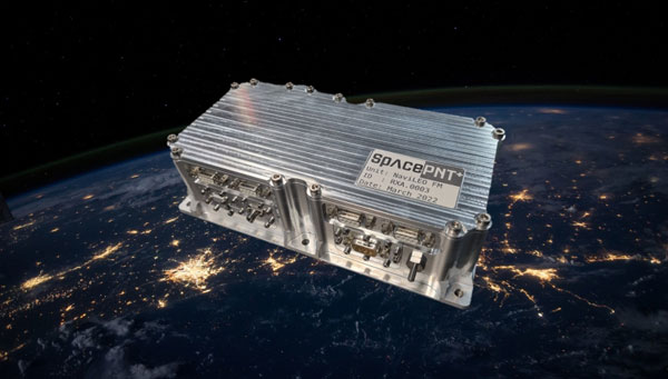
SpacePNT SA — established in 2020 in Neuchâtel, Switzerland — provides advanced PNT technologies and solutions for satellites. I discussed the company and its products with its co-founder and CEO, Cyril Botteron.
What is your company’s niche within PNT?
We have developed our own FPGA-based hardware/software/firmware spaceborne GNSS receiver technology specially targeting the fast-growing New Space satellite market and the demanding applications requiring real-time and on-board dm-level positioning and ns timing accuracy, or highest signal reception sensitivity for GEO or Moon missions.
What is your background and that of the other people in the company?
I have been working in the PNT domain since 1999, when I started my Ph.D. in wireless localization at the University of Calgary, in Canada. Then, after finishing my Ph.D. in early 2003, I joined the Institute of Microtechnology in Neuchâtel, Switzerland and transferred a few years later to the Swiss Federal Institute of Technology Lausanne (EPFL). There, for more than 15 years, I led PNT and GNSS receiver R&D activities, several in connection with the Galileo project, which was just starting back then. In parallel, I also worked as part-time Galileo GNSS receiver expert for the European Commission for more than 10 years.
Today, SpacePNT is still growing and counts 11 people including the equivalent of 7-8 full-time engineers with many years of experience in their respective domains who have entirely developed the company’s hardware and software technology. Some of them followed me from EPFL at SpacePNT, while others were previously working for Syderal Swiss, a company that has developed electronics and space equipment for more than 50 missions without any failure, but that, unfortunately, stopped its operations in 2022.
One particularity about our core engineering team is that we have been able to bring together very talented and complementary people, allowing us to perform all the electrical and software design, analysis, development, verification, and qualification engineering tasks of our FPGA-based spaceborne GNSS receiver products internally. I think this is quite remarkable given our still relatively small size and the tremendous complexity in developing satellite GNSS receivers.
What are the origins of your company’s current product offerings?
It all started in EPFL more than 10 years ago, after we had developed some advanced FPGA-based GNSS receiver acquisition algorithms as part of an EU Galileo project aiming to acquire the GPS signals in difficult indoor environments, without assistance and with a very short time-to-first-fix. At that time, we realized that such algorithms could also be used to enable autonomous space navigation toward the moon thanks to the terrestrial GNSS signals. Indeed, when you are at moon altitude, or about 400,000 kilometers from here, it is very difficult to acquire the GNSS signals because they are so attenuated and there is no assistance network up there to help with the GNSS signal acquisition process.
So, we started to build a first proof-of-concept prototype implemented on a powerful FPGA commercial development board to see whether it was possible to acquire the GPS L1C/A signals at moon altitude. After a successful demonstration and because from the moon you cannot see so many satellites from a single GNSS constellation, we added to the prototype the capability to also receive the Galileo E1 signals in order to compute a position fix. Then, in order to improve the least-squares solution we were obtaining — which was very coarse, with an accuracy of several kilometers — we decided to add a second frequency in order to take advantage of the modernized GPS L5 and Galileo E5a signals providing better pseudo-range observables.
After that, the accuracy of the receiver prototype was still limited to a few kilometers at moon altitude due to the poor system geometry. Indeed, from a moon user perspective, all the GNSS satellites are constrained in the same direction towards Earth, leading to a huge dilution of geometry on the order of 1000. This means that even if the pseudo-range observables are estimated with a 1-meter accuracy, the position accuracy will still be on the order of 1000 m because of the poor system geometry. So, we made two additional important improvements. The first one was the addition in the receiver of a model of orbital forces to model all forces acting on the satellite and filter the solution. The second one was to aid the acquisition algorithms from the navigation solution to acquire more rapidly new GNSS signals.
At the end of 2017, we finally achieved a successful hardware-in-the-loop demonstration in our laboratory with this proof-of-concept prototype fed by a real radio frequency signal generated using a GPS+Galileo full constellation Spirent simulator, demonstrating an accuracy of just a few hundreds of meters at moon altitude. It is at that time that part of my EPFL team and I decided to leverage the knowledge we had accumulated toward the development of a commercial spaceborne GNSS receiver product.
Interestingly, the first product we started to develop was not a moon receiver but one targeting LEO satellites and LEO constellations called NaviLEO, because there was more demand for solutions covering LEO orbit satellites than for moon mission, especially in 2019. Today, moon PNT technology is also becoming very important.
How did you become involved with the European Space Agency’s moon mission?
After we started the development of our first NaviLEO spaceborne GNSS receiver product, we won an open competitive call from the European Space Agency (ESA) to develop a moon GNSS receiver prototype that we named NaviMoon. This development built upon the NaviLEO spaceborne receiver development that integrated high-performance, radiation-tolerant COTS EEE components and a radiation-tolerant HW/SW/FW architecture, including latch-up protections and ECC, but this time with a better clock and improved super-high-sensitivity algorithms.
What are the special challenges of making a lunar GNSS receiver?
There are several of them as the super-high sensitivity algorithms and the navigation algorithms are quite complex. One special challenge we had to overcome was related to the hardware. Indeed, for the proof-of-concept, we realized at EPFL, we used a commercial development board integrating a very large FPGA, which allowed us to rapidly develop the algorithms without being limited with the FPGA computational resources. However, when you need to make a space product, then you need to select radiation-tolerant components and also want to minimize power consumption, so the choice of a suitable radiation-tolerant FPGA is very limited. Therefore, a main challenge during the lunar receiver prototype development was to develop super-high sensitivity GNSS algorithms that could fit within the limited computational resources of the NaviLEO hardware. In addition, we also needed to find a better radiation-tolerant low-phase-noise clock allowing very long coherent integrations of the received signals to extract them from the environmental thermal noise.
What happened next?
After the first ESA contract to develop this NaviMoon engineering model, we won a follow-up competitive ESA call to build a flight model that ESA will send around the moon circa 2025 to demonstrate for the first time the use of terrestrial GNSS signals for autonomous navigation in a cislunar orbit. For the manufacturing and testing of the hardware, we partnered in this project with European Engineering & Consultancy (EECL) in the UK. Surrey Satellite Technology (SSTL), also in the UK, is the satellite prime in charge of the ESA/SSTL Lunar Pathfinder satellite that will host our NaviMoon receiver. It will also host a laser retroreflector array that will make it possible to verify the real-time positioning accuracy provided by the receiver in cislunar orbit. We already delivered the flight model to SSTL in June of last year and are very much looking forward to this in-cislunar orbit demonstration. It will be the culmination of a very long development that started 10 years ago at EPFL and has only been possible thanks to the hard work and dedication of all the people who worked on it, including the support from ESA.
What are your key innovations?
Besides the fully in-flight reprogrammable radiation-tolerant hardware we developed and the super-high sensitivity algorithms and orbital forces model integrated in our NaviMoon navigation filter, another key innovation we developed at SpacePNT is our own precise orbit determination (POD) algorithm that can process the clock and ephemeris corrections transmitted in real-time by Galileo satellites (the High Accuracy Service) or by GEO satellites (the Fugro SpaceStar service) and that we are integrating into our NaviLEO-POD product. Thanks to these real-time corrections received from the same GNSS antenna as used to receive the GNSS signals, our NaviLEO POD receiver technology can deliver to the other payloads onboard the satellites, totally autonomously and in real-time, a position and a time with sub-decimeter and ns-level accuracy, which is outstanding if we think of the velocity of a LEO satellite, which travels at a speed more than several tens of thousands of km/h.
One of your press releases refers to NaviLEO as a “spaceborne GNSS receiver product platform.” What does that mean?
When we started the development of our first GNSS product, NaviLEO, we already had in mind the development in the near future of additional receiver products to cover additional markets, e.g., with dual-antenna to provide optimal visibility from LEO to GEO, or with a better on-board clock to enable autonomous moon navigation. This is why we developed the original NaviLEO hardware as a flexible “product platform” or “technological base” that our other spaceborne GNSS receiver products could inherit and build upon.
This is also why I said in that press release that the successful in-orbit demonstration of our NaviLEO receiver product platform is a significant achievement towards future missions. What I meant is that the NaviMoon flight model we already delivered to ESA last year, as well as other NaviLEO flight models we are delivering to other customers this year, are also based on the same fully in-flight reprogrammable technological platform as NaviLEO. Therefore, having this receiver platform already successfully demonstrated in a LEO environment is a great achievement towards the future missions, including the coming ESA/SSTL Lunar Pathfinder demonstration in cislunar orbit. Moreover, this in-orbit validation has also allowed us to de-risk our second-generation product platform, because our second generation reuses the same key radiation-tolerant electronics components, repacked to enable a more cost-effective and larger-scale manufacturing.
Are you mostly targeting telecoms?
The large LEO telecom constellations are one of our main targets for our second-generation product. Indeed, given the large quantities involved and the market pressure to make the satellites cheaper, it is necessary to develop a technology well-optimized for cost reduction and serial manufacturing. That is something we clearly had in mind when we defined the requirements of our second-generation hardware product that we will qualify in the coming months. We are also targeting additional markets, both with our current first-generation and coming second-generation products, for instance, the Earth observation market or LEOPNT market for which decimeter and nanosecond accuracy can make a huge difference to the quality and performance of the services these satellites can deliver to the end-users, or the GEO and Moon markets for which our super-high-sensitivity receiver technology is perfectly suited.
Use of a NaviLEO-POD receiver onboard each satellite of a LEO-PNT constellation, allowing the autonomous generation of PNT signals within each satellite. (Image: SpacePNT)
What are the key technical challenges using GNSS satellites “from the other side,” so to speak?
What makes it extremely difficult to use GNSS satellites at altitudes above them is the fact that GNSS satellites always have their main lobe antenna gain directed toward Earth and do not transmit any signal power toward outer space. So, when you are above a GNSS constellation, you cannot receive any signal power from the satellites directly beneath you, and in fact the only signals you can receive are coming from the spillover around Earth of the satellites that are on the other side of Earth, or that come from the secondary side lobes of the GNSS transmit antennas.
Since the antenna gain of the secondary side lobe is reduced by about 14dB as compared to the main lobe directed toward Earth, this is yet another reason why super-high-sensitivity algorithms are needed for moon and GEO missions, to allow the use of these lower power signals transmitted by the GNSS secondary antenna side lobes.
More specifically, what are the challenges of moon navigation?
Moon navigation, whether in transit to the moon, in a lunar orbit, or on the lunar surface represents several challenges. These include the definition of a reference time and geometric reference frame to be used on the moon, and the definition of standards for communications and positioning to be followed by the different moon users and moon service providers in order to achieve interoperability, amongst others.
Do ESA and NASA plan to place navigation satellites in orbit around the moon? If that’s the case, are you bridging the gap until the new system is deployed?
Yes, exactly. NASA and ESA are collaborating to define the LunaNet Interoperability Specification. It is a common framework of mutually agreed standards to be applied by users and service providers in a cooperative network and support missions on and around the moon. In this framework, PNT services are envisioned to be provided in two ways to lunar users, through dedicated communication links and through a GNSS-like lunar navigation system.
As there is no such infrastructure available yet, however, our NaviMoon GNSS receiver solution that ESA will demonstrate as part of the ESA/SSTL Lunar Pathfinder mission circa 2025 is a first step toward the effort to develop lunar PNT capabilities. It will also illustrate how GNSS can play a meaningful role in lunar PNT, analogously to the way that LEO-PNT complements GNSS for Earth users.
How can your system contribute to complementary PNT?
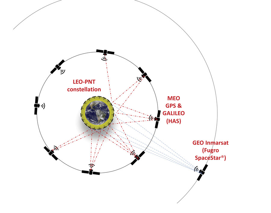
In a nutshell, a complementary PNT constellation can provide PNT services similar to a GNSS system, making each LEO-PNT satellite transmit PNT signals that contain both its real-time ephemeris and time of transmission. To do that, what every LEO satellite of a LEO-PNT constellation needs is a means to compute its own precise ephemeris and to precisely synchronize its time-frequency with the others. This is exactly what our NaviLEO POD solution can do. Thanks to its on-board real-time POD algorithm and the real-time GNSS clock and ephemeris corrections it can receive from GEO satellites, such as Fugro SpaceStar service, or from MEO satellites, such as the Galileo high accuracy service, it can disseminate within the satellite the real-time precise orbit determination of the satellite needed to compute and transmit its own precise ephemeris. It can also compute and transmit the ns-level timing frequency synchronization with GPS or Galileo system time. The LEO-PNT satellite can then use these data to generate the PNT timing signals sent toward the PNT terrestrial users. The beauty of this concept is that there is no need for inter-satellite links, additional ground station infrastructure or atomic clocks on the LEO-PNT satellites. The GNSS receiver equipment can do it all by itself, delivering a time fully synchronized with a GNSS time scale that is maintained by the atomic clocks onboard the GNSS monitor stations and GNSS satellites. Our system is also resilient to short GNSS outages, thanks to NaviLEO POD’s advanced algorithms that optimally combine the multi-constellation multi-frequency GNSS measurements with a precise model of orbital forces allowing the propagation of the navigation even in the absence of GNSS measurements. Finally, what I think is remarkable is that thanks to the MEO or GEO real-time correction signals used to correct the ephemeris and clock errors present in the real-time signals transmitted by the GNSS satellites, a LEO-PNT satellite equipped with our solution can potentially transmit ephemeris and clock signals towards the terrestrial users that contain fewer errors than the real-time ones transmitted by today’s GNSS satellites.
Plus, of course, the received signal on Earth from LEO satellites is much, much stronger than that from GNSS satellites, which has many advantages, right?
Absolutely. The additional power means that signals transmitted from LEO satellites are much more difficult to jam or spoof, thanks to the higher received signal power. In addition, because the LEO satellites travel much faster than the GNSS satellites above a terrestrial user, the signals are much more dynamic. So, even if one wanted to make a very complex spoofing attack with UAVs, everything is so dynamic and moving so fast, that it would be very difficult to implement. This may make the receiver more complex but also brings advantages. For instance, if one user application does not need a high accuracy fix, it is possible to use the Doppler effect to locate a receiver with just one or two LEO satellites.
Are you working on any other related projects?
We are also working on an enhanced orbit propagation tool called SimORBIT and commercialized by Spirent. It enables realistic testing of emerging LEO satellite constellations with the generation of output files in SP3-c format, as well as in the proprietary Spirent MOT and MOTI formats. We are also constantly improving our receiver technology and widening our product offerings.
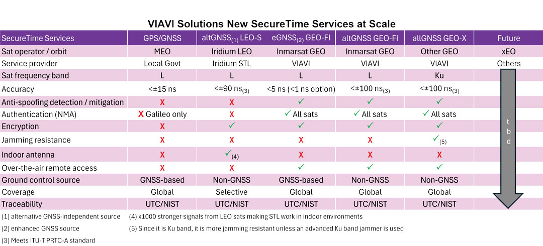
VIAVI Solutions — with corporate headquarters in Chandler, Arizona, and offices in 22 countries — makes a wide array of testing solutions for network operators, equipment manufacturers, enterprises, government, aerospace, and railways. I spoke with Nino De Falcis, Senior Director, Global PNT Business Development.
What problem are you addressing?
A GNSS clock is a single point of failure and is at risk of cyber-attacks that are on the rise, such as jamming and spoofing. In a typical configuration, a GNSS legacy clock includes an antenna, a receiver, a holdover oscillator and fan-out input/output. The GNSS antenna is the point of attack for many bad guys. That’s the problem we are addressing in the critical infrastructure that we are serving, including defense, 5G, public safety, utilities, data centers, financial systems and transportation. Bad guys now have also demonstrated that they can jam or even, in Russia’s case, shoot down GNSS satellites, which makes GNSS even more vulnerable, both in space and on the ground. GNSS constellations do not have spoofing detection or mitigation through authentication, except for Galileo’s Open Service Navigation Message Authentication (OSNMA). Additionally, their signals are not encrypted, so they are easy to spoof and do not work indoors.
What is your solution?
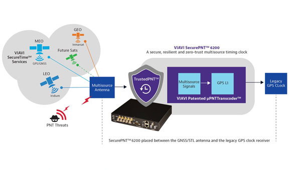
Instead of replacing the hundreds of thousands of legacy GNSS clocks that are deployed, we are just adding our box in line between the antenna and the receiver, as an accessory. We call it the zero-trust multisource PNT clock, and it is our new SecurePNT-6200 product. Additionally, we offer our new suite of SecureTime services, which combines multiple signals of opportunity, coupled with the 6200 clock. We already have Iridium LEO and Inmarsat GEO sources and will soon add support for other future satellites as well as terrestrial sources. You can even aggregate a stand-alone cesium clock into our resilient 6200 clock. Then, we output the legacy signal to feed it to the GPS receiver.
Our resilient multi-source clock aggregates all those signals of opportunity, and then AI sensor fusion weighs, cross-verifies, authenticates, qualifies. It does a lot of processing to select the best uncompromised source. The source is then converted to the legacy GPS L1 signal before feeding it to the GPS receiver. We call it a transcoder and have a patent on this technology. We are the only company offering this solution, though we allow third parties to do the same.
How are you processing your data?
We’re inputting all the constellations — almanacs, ephemerides, etc. — and fusing all those internal and external sources, weighing their quality and estimating the PNT state. We then apply the zero-trust, AI-based jamming and spoofing detection and mitigation. So, we’re doing the authentication, the verification, the qualification, the learning of patterns using all the data sets that we are accumulating between those different sources from GNSS, LEO, GEO or cesium clocks. We can also aggregate sources from the ground, such as eLoran or any terrestrial source that could be activated in the next two or three years. When we switch from one source to another — in the sky, in space, and/or on the ground — we go quickly into holdover so that we don’t have a phase hit during the switchover.
What is your timing source?
Our ground control stations are connected to the NIST to provide a GNSS-independent timing source. So, our solution doesn’t depend on GNSS and its coverage is global and traceable to UTC.
How do LEO and GEO complement each other?
Through Iridium LEO, we’re addressing the encryption, jamming protection, and indoor antenna capabilities that GNSS does not have. However, there are still two missing pieces: spoofing detection and authentication. To address those two gaps of Iridium, we have Fugro Inmarsat GEO, both in L-band and Ku band. Some end users have already approached us and will receive a combination of all three sources — GNSS, LEO and GEO. By the time you get all of those, if anything happens in a critical infrastructure, you’re covered. It is just a matter of your risk profile and how much you want to pay for these services. There is not one service that fits all. The pros and cons of each service are presented in the table above.
What unique capability does VIAVI offer?
We are the only company today that can provide multi-orbit, multi-constellation, multi-band capability. All the solutions — GPS, Iridium and Inmarsat — are L-band, but we are going to come out with Ku band capability, too. Jamming and spoofing Ku band will be much, much more difficult than doing it in L-band, which has already been jammed and spoofed in known warzones, because the frequency is so high and if you get jammed, you can easily switch to a different transponder, and there are many of them. For the defense applications that we are serving, this capability can be the difference between winning or losing a war. We have many engagements with defense accounts, as well as commercial and government accounts and our solution has been embraced very successfully so far.
What performance have you achieved?
We have built spoofing detection into our product for defense-in-depth attacks. We are offering 5 ns accuracy to UTC and can go down to 1 ns accuracy using our new SecureTime eGNSS service. That is breakthrough performance. If you look at GPS, we are at 15 ns with a high-end receiver, but typical receivers are in the 20 ns to 30 ns range, so we’re at least 15 times better than that.
To detect jamming and spoofing, we see all the different signals from space and ground, if any, and map them into our AI fusion software platform that we have, which is our new TrustedPNT technology. These services have been tested and proven in live-sky battlefield scenarios at USAF’s NAVFEST 2024 Test Event in May 2024, including successfully providing assured PNT in a simulated warzone with complete denial of GPS and GNSS services. When attacked, our solution switched from GPS to LEO source and then from LEO to GEO, while surviving the various jamming and spoofing attacks. Once the attack stops, we fail back to GPS. If we add more sources, we will be able to switch from one to another depending on the relevant weaknesses, while amalgamating the different sources to create a solution that is higher in performance than any one constellation by itself.
In conclusion?
Adding an accessory costs a lot less than replacing your legacy clock. Additionally, adding diversified sources from multiple orbits and bands can significantly bolster the robustness and survivability of your overall PNT solution.
GNSS — delivering up to millimeter accuracy from 20,200 km in space with a received signal of one tenth of one millionth of one billionth of a Watt — is, in Arthur C. Clarke’s famous definition, “indistinguishable from magic.” Yet, in addition to the inherent errors in the transmission, propagation, and reception of their signals, GNSS are increasingly challenged by jamming and spoofing attacks, especially in and near conflict zones.
For that reason, as any regular reader of this magazine knows, combating jamming and spoofing and building resilience in positioning, navigation, and timing (PNT) systems has been a constant theme of many of our articles and industry news items for years.
The U.S. National Space-Based Positioning, Navigation and Timing Advisory Board has been focusing on how to “protect, toughen and augment” GPS, with the third word referring both to enhancements to GPS and to the “provision and use of alternate sources of PNT that complement, back up, or replace (partly or entirely) use of GPS.”(*)
For this cover story, I discussed complementary sources of PNT with executives from four companies that design, produce, and/or operate them. They cover a wide range of complementary PNT technologies. Read the exclusive interviews below:
Iridium owns and operates a constellation of satellites in low-Earth orbit (LEO) and has global rights for L-band spectrum. This enables it to operate the Satellite Time and Location (STL) system developed by Satelles before it recently became part of Iridium. STL protects critical infrastructure by providing a timing signal that is independent of GNSS constellations and 1,000 times stronger than the GPS signal.
Spirent Communications’ latest simulation system brings together GNSS and a wide range of other PNT systems. It simulates L-band, S-band, alternative navigation signals, signals of opportunity and emulated inertial outputs. It focuses particularly on the new and emerging LEO constellations, including Xona Space Systems’ PULSAR signals, and enables users to inject new signals via I/Q data files.
SpacePNT has developed an FPGA-based hardware/software/firmware spaceborne GNSS receiver technology specifically targeting the fast-growing New Space satellite market. The company’s innovations include a precise orbit determination algorithm that can process signals from the Galileo High Accuracy Service and from geostationary orbit (GEO) satellites.
VIAVI Solutions has developed a system that aggregates signals of opportunity, as well as Iridium LEO and Inmarsat GEO sources; weighs and cross-verifies them; then converts the output to the legacy GPS L1 signal and feeds it to a GPS receiver. It can also aggregate a stand-alone cesium clock.
(*) From Dr. John Betz’s presentation on “Augmenting GPS for Critical Infrastructure” at the April 24, 2024, meeting of the PNT Advisory Board.
SandboxAQ has released AQNav, designed for navigation across air, land and sea when GPS signals are jammed or unavailable.
As of June 2024, AQNav has logged more than 200 flight hours and 40 sorties across multiple regions of the world on four different aircraft types, ranging in size from single-engine planes to large military transport aircraft.
AQNav is a geomagnetic navigation system that uses proprietary artificial intelligence (AI) algorithms, powerful quantum sensors and the Earth’s crustal magnetic field. The system seeks to provide an un-jammable, all-weather, terrain-agnostic, real-time navigation solution in situations where GPS signals are unavailable, denied or spoofed.
The system uses extremely sensitive quantum magnetometers to acquire data from Earth’s crustal magnetic field, which exhibits geographically unique patterns – similar to a human fingerprint. AQNav uses AI algorithms to compare this data against known magnetic maps, allowing the system to quickly and accurately find its position. Due to the high sensitivity of quantum sensors, AI algorithms are applied to improve the signal-to-noise ratio, removing any mechanical, electrical or other interference that would impact the system’s ability to acquire its location.
It is available globally and can be used in air, land and sea applications. The system does not rely on visual ground features or satellite transmissions to function and is not affected by weather conditions.
AQNav operates at room temperature, requires no shielding and has a small form factor that can be integrated into a wide variety of platforms, from multi-engine airliners to UAVs. Its passive technology emits no electronic signals, which reduces the aircraft’s detectability.
AQNav seeks to increase useful navigation for aircraft navigating within the frameworks of regulatory bodies such as the International Civil Aviation Organization and the Federal Aviation Administration (FAA). SandboxAQ and its partners are continuing to explore a broad range of use cases for both commercial and defense applications.
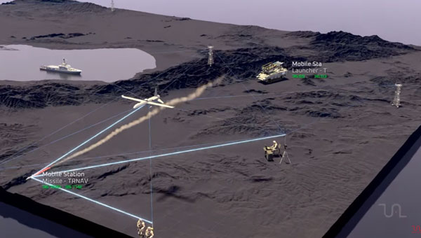
Tualcom has released TRNAV, a terrestrial navigation solution designed to operate with or without GNSS signals.
TRNAV establishes a mesh network of ground stations capable of operating independently from GNSS by using precise pre-established locations or connecting to GNSS when available. The system maintains location accuracy comparable to GNSS by connecting to at least three ground stations. Its highly synchronized timing system ensures a minimal drift of 10ns over a week without GNSS.
The system features a re-synchronization capability that allows the entire network to be updated instantly when just one station reconnects to a GNSS satellite, maintaining high precision across all platforms. Users can integrate mobile stations to enhance network flexibility and range, with the potential to cover distances up to 250km under ideal conditions.
TRNAV also offers a high-bandwidth communication channel for various data types, which offers extensive communication capabilities within the established network. The system employs AES-256 encryption and advanced waveform technologies, including DSSS/FHSS for robust and secure operations even in challenging environments.
As GNSS integrity and availability face increasing threats, TRNAV provides a reliable and resilient alternative for assured positioning, navigation and timing (PNT). Whether in defense, emergency response, or critical infrastructure, TRNAV’s adaptable architecture offers seamless and secure navigation and communication.
Iridium Communications has expanded the commercial availability of its Satellite Time and Location (STL) service to parts of Europe and the Asia Pacific. This expansion is driven by increasing demand and aims to provide an alternative positioning, navigation and timing (PNT) solution to protect critical infrastructure against GPS and Galileo spoofing and jamming.
The Iridium STL service, capable of operating globally, is designed to ensure the fidelity of timing systems with a signal 1,000 times more powerful than GPS. This makes it particularly suited for indoor use without the need for rooftop antennas, offering a secure and cost-effective solution for sectors such as transportation, energy grids, data centers, telecommunications networks and financial services.
The expansion follows a significant rise in GPS jamming and spoofing activities in Europe and parts of Asia, posing serious threats to critical infrastructure. The newly available STL service is designed to help safeguard essential systems and improve operational security and efficiency.
The STL solutions are designed to be small, cost-effective and easy to install. These solutions can be integrated into existing GNSS-reliant systems or used as stand-alone units.
With the expanded authorization, Iridium STL can now be purchased by companies in North America, parts of Europe and the Asia Pacific region. The company plans to continue scaling and training sales and support staff to further extend the service’s global reach.