Category: Complementary PNT

  • NAL Research, VectorNav collaborate on solution for GNSS/GPS-denied environments

    NAL Research, VectorNav collaborate on solution for GNSS/GPS-denied environments

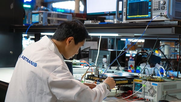
    NAL Research and VectorNav Technologies — two U.S.-based leaders in assured position, navigation, and timing (APNT) solutions — are joining forces to develop and produce Iridium STL (satellite time and location)-aided inertial navigation systems (INS) designed to meet the increasing demand for resilient PNT in GNSS-denied environments.

    Both companies will be exhibiting and discussing the collaboration during the SOF Week Exposition in Tampa, Florida, May 5–8, NAL Research (#3005) and VectorNav (#1941).

    Operators of uncrewed systems, in particular, can benefit from implementing an INS solution that leverages NAL’s Iridium STL-enabled APNT receivers to maintain critical operations in areas where GPS/GNSS signals are denied or degraded.

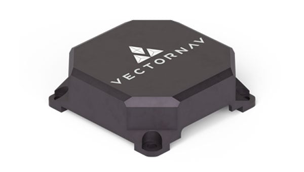
    For such applications, VectorNav is leveraging its VN-210E GNSS-aided INS, which combines a tactical-grade IMU with an L1/L2 GNSS receiver in a miniature, board-mount package. Designed for maximum modularity, the VN-210E hosts VectorNav’s tightly coupled INS and includes four serial ports that enable simultaneous integration with multiple external PNT-aiding sources, such as NAL Research’s ALTM Gen2 Mini Iridium STL receiver. When paired, the system provides a high-rate and continuous position, velocity and attitude solution — even in dynamic applications and in GNSS-denied environments.

    “This complete offering delivered through our high velocity collaboration with VectorNav will deliver dynamic innovation to the emerging APNT market,” said NAL Research President Robert Bills. “Our partnership streamlines our customers’ implementation of alternative APNT sources. We look forward to helping government and enterprise users achieve operational success by enabling the ability to rapidly implement highly accurate and reliable navigation solutions.”

    NAL Research and VectorNav will continue to focus on co-developing product solutions that combine VectorNav’s industrial and tactical-grade INS with NAL Research’s Iridium STL receivers. Future offerings will focus on reducing SWaP-C (size,  weight, power and cost), increasing environmental resilience, and supporting MIL-STD compliance for defense and aerospace applications.

    “The demand for robust APNT solutions, manufactured at scale and capable of supporting dynamic autonomous systems, is growing rapidly — particularly in the critical maritime domain,” said Jakub Maslikowski, VP of business development for VectorNav. “This collaboration with NAL Research will help to realize the emerging LEO satellite PNT capability and strengthen the U.S. and allied nations’ resilience when operating in contested environments.”

  • Q-CTRL demonstrates quantum navigation system as GPS backup

    Q-CTRL demonstrates quantum navigation system as GPS backup

    A team of researchers at Q-CTRL, a quantum infrastructure software company based in Sydney, Australia, has completed a successful demonstration of a new quantum navigation system called Ironstone Opal. The group described the system’s operation and performance in a paper posted to the arXiv preprint server.

    GPS technology is widely used for navigation in both civilian and military vehicles and aircraft. However, the increasing reliance on GPS has highlighted its vulnerability to outages, which can leave drivers stranded, force pilots to rely on outdated methods and complicate the deployment of military assets. These concerns have driven efforts worldwide to develop robust backup systems or alternatives to GPS.

    Q-CTRL’s Ironstone Opal is designed as a backup navigation system and, according to the research team, can deliver accuracy up to 50 times greater than existing GPS backup systems in certain scenarios. The system leverages quantum sensors that are highly sensitive to variations in the Earth’s magnetic field. Because the magnetic field differs depending on geographic location, these sensors can precisely determine an object’s position by reading the field and using artificial intelligence-based software to generate geographic coordinates similar to those provided by GPS.

    The research team shared that unlike conventional systems, Ironstone Opal is passive, meaning it does not emit signals that could be detected or jammed by adversaries. The system’s software is designed to filter out noise from vehicles or aircraft carrying the sensors, and the hardware is compact enough for installation in cars, trucks, UAVs and aircraft.

    Field trials conducted by Q-CTRL included both ground vehicles and aircraft. The results showed that Ironstone Opal outperformed a high-end inertial navigation system, a standard GPS backup, by up to 50 times in ground tests and by at least 11 times in airborne tests. These trials demonstrated the system’s ability to maintain high accuracy under a range of environmental conditions, altitudes, and maneuvers, with positioning uncertainty as low as 0.01% of the total distance traveled in the best cases.

    Q-CTRL’s approach combines proprietary quantum magnetometers with advanced denoising and map-matching software, allowing the system to detect subtle magnetic “landmarks” in the Earth’s structure. The technology is designed to be resilient, unjammable, and suitable for integration into a wide range of platforms, including autonomous vehicles and commercial aircraft.

  • TrustPoint secures NAVAIR contract for C-band GNSS receivers

    TrustPoint secures NAVAIR contract for C-band GNSS receivers

    The United States Navy’s Naval Air Systems Command (NAVAIR) has awarded TrustPoint a $1.2 million Small Business Innovation Research Phase II contract. The funding supports the initial delivery and demonstration of TrustPoint’s C-band GNSS service-enabled receivers for the U.S. government. TrustPoint is collaborating with Hexagon U.S. Federal and NovAtel, both part of Hexagon.

    This project combines TrustPoint’s C-band services with NovAtel’s GNSS receiver technology, aiming to advance resilient positioning, navigation and timing solutions for military use. The partnership draws on extensive experience in military-grade GNSS equipment and services, and represents a significant step in developing technology that can operate reliably in challenging operational environments.

    The contract highlights the increasing importance of frequency and orbital diversity for future navigation and timing needs. With Hexagon as a key partner, TrustPoint is positioned to address the Department of Defense’s evolving requirements for assured PNT, supporting mission continuity even in contested environments

  • Flawed spectrum proposal could cause disruption and risks to public safety

    Flawed spectrum proposal could cause disruption and risks to public safety

    On March 27, 2025, the Federal Communications Commission (FCC) launched a proceeding on commercial technologies that would complement GPS. “Although GPS is indispensable to America’s economic and national security, it represents a single point of failure that can be vulnerable to disruption or manipulation by our adversaries,” said the FCC’s announcement, highlighting the federal government’s bipartisan call to develop complementary systems that provide positioning, navigation and timing (PNT) data to to better achieve PNT resilience nationwide and protect America’s economic and national security.

    The Security Industry Association (SIA) commends the FCC’s commitment to protecting America’s economic and national security and exploring available PNT options. We believe the docket will show that there is a wide array of PNT technologies that can complement to GPS, and we look forward to providing information to the Commission about tradeoffs among these emerging PNT offerings and encouraging the Commission to avoid taking action that could disproportionately disrupt valuable public safety technologies.

    One company, the for-profit entity NextNav, has petitioned the FCC to reconfigure the 902-928 MHz band (the Lower 900 MHz frequency) and grant it a nationwide license for 15 MHz of spectrum so it can establish a 5G terrestrial-based PNT network. NextNav also seeks the removal of the current requirement that it not cause unacceptable levels of interference to Part 15 devices. These devices include low-power, radio frequency (RF) devices ranging from consumer electronics and appliances to wireless alarm systems, smart home equipment, electronic access control devices and a wide range of devices used to increase economic productivity and efficiency, bolster safety, deliver innovation and provide other important benefits to consumers. This proposal has a dangerous likelihood of causing significant interference in the band that would be adverse to the public interest and threaten public safety.

    The Lower 900 MHz band is vital for millions of security cameras, including popular models used in homes and small businesses. These devices are essential for protecting homes, preventing package theft and home intrusions, ensuring children’s safety and aiding law enforcement by capturing criminal activity. The changes proposed by NextNav would likely force these incumbent users into a shared portion of spectrum that is almost 60% smaller than the current Lower 900 MHz band — crowding that will cause many devices to stop operating reliably, compromising Americans’ safety and the security of our facilities and communities, and will be exacerbated by the growing concentration of devices using new technologies that require more spectrum bandwidth.

    Another important service likely to be disrupted by the proposed band restructuring would be Z-Wave technologies. Z-Wave technology enables comprehensive home automation and security solutions —such as smart locks, thermostats and security systems — to integrate seamlessly with various smart home devices, while preserving advanced security features such as encrypted communication and secure inclusion. Z-Wave devices are not designed to withstand interference from fixed and/or mobile devices operating at commercial macro power limits and out-of-band emission limits, such as those in NextNav’s proposed high-power operations.

    Additionally, millions of electronic access control and other wireless connected devices that are now in use in residential, institutional, commercial and government buildings across the United States would be impacted. The interference generated from NextNav’s higher-power communications would significantly impact the reliability of these important safety and security products and ecosystems, effectively making them unusable in the same spectrum.

    In addition to these public safety and security uses, more critical systems that could be disrupted include:

    • Municipal infrastructure, including such systems as traffic control, street lighting, weather monitors and flood warning systems that are deployed in this band to make communities safer and more energy efficient.
    • Critical infrastructure, including utilities’ use of the band for remote monitoring and management of power, gas and water distribution networks.
    • Railroad operations and safety, including the Automatic Equipment Identification network that enables tracking of rail cars and equipment, as well as essential traffic control, sensors and other devices necessary for operational safety and efficiency.
    • Highway infrastructure and tolling, including the operation of electronic tolling systems, such as E-ZPass and other similar toll collection systems.
    • Retail, manufacturing and supply chain operations, including building control systems, tank and leak monitoring system and inventory control systems.
    • Agriculture solutions used for connecting modern farms’ Internet of Things devices and equipment to keep our farms connected.

    As other concerned parties have pointed out, there are a number of existing backup GPS options available to establish a terrestrial PNT without any reallocation of spectrum.   While a backup GPS system is ultimately necessary, the other solutions that would be much less disruptive. The tradeoffs required by implementing the NextNav proposal are simply not worth the risk to our nation’s security and safety.

  • Sierra Space successfully tests resilient GPS technology for US Space Force

    Sierra Space successfully tests resilient GPS technology for US Space Force

    Sierra Space has successfully demonstrated its Resilient GPS (R-GPS) technology for the U.S. Space Force (USSF). This milestone, achieved in collaboration with General Dynamics Mission Systems, involved generating all GPS navigation signals required for the R-GPS mission. The technology seeks to address the growing need for resilient GPS systems capable of countering threats such as jamming and spoofing, which pose risks to the current GPS infrastructure.

    GPS technology is integral to modern life, supporting civilian applications from smartphone navigation to critical military operations. However, as adversarial threats become increasingly advanced, there is a pressing need to enhance GPS resilience. To tackle this challenge, the USSF’s Quick Start program is focused on integrating smaller, cost-effective satellites into the existing GPS framework. These satellites would provide a rapidly deployable layer of protection against emerging threats, according to the USSF.

    The demonstration evaluated hardware, firmware, and software performance, including the generation of P(Y), M-code and C/A signals at L1 and L2 frequencies. These capabilities ensure that R-GPS satellites can produce accurate and secure navigation signals compatible with devices used globally.

    Sierra Space was awarded an R-GPS contract by the USSF Space Systems Command in September 2024 to develop design concepts for smaller and more affordable satellites. Following an internal Systems Requirements Review later that year, the company has now demonstrated its technological capabilities within months of the program’s inception.

  • FCC seeks public input to strengthen alternative PNT

    FCC seeks public input to strengthen alternative PNT

    The Federal Communications Commission (FCC) has issued a Notice of Inquiry (NOI) seeking public input on positioning, navigation and timing (PNT) systems and policies. While GPS is crucial for the United States’ economic and national security, its dependency as a single point of failure renders it vulnerable to disruption or manipulation by adversaries. Recognizing this vulnerability, leaders such as President Trump, Chairman Cruz, and Senator Markey have advocated for developing alternative systems to ensure resilient PNT capabilities.

    PNT data is integral to countless military, public safety, agricultural, and commercial activities. Given the dependence of the American economy and national security on GPS as the sole PNT source, the agency states that the U.S. government is prioritizing efforts to create robust backup systems that can safeguard essential functions in the event of GPS signal disruptions.

    The FCC’s NOI examines how the agency can foster the development of alternative and complementary PNT. It seeks feedback on various emerging PNT technologies being developed by broadcasters, wireless operators, satellite constellations and startups utilizing FCC-licensed spectrum. The inquiry also addresses tradeoffs among these technologies based on performance, scalability, geographic coverage, durability, cost and commercialization potential.

    The Commission aims to establish a comprehensive record to guide its actions in enhancing GPS resilience and promoting alternative PNT solutions. Potential measures include regulatory changes, public-private partnerships, testbeds, Innovation Zones and other initiatives.

    Two PNT-related petitions are currently under FCC consideration. NextNav has proposed allocating approximately $5 billion worth of spectrum to collaborate with telecom providers in establishing a PNT network. Meanwhile, the National Association of Broadcasters (NAB) has suggested adopting a new TV signal format capable of transmitting PNT information without requesting additional spectrum allocation. Insights from the NOI will help inform decisions on these proposals.

    The FCC’s inquiry reflects growing concerns about reliance on GPS as a single system for PNT data. By fostering alternatives like terrestrial networks or broadcast-based solutions such as NAB’s Broadcast Positioning System, the Commission seeks to strengthen national resilience against potential disruptions to critical infrastructure and services.

  • UN agencies denounce GNSS interference

    UN agencies denounce GNSS interference

    The International Telecommunications Union (ITU), International Maritime Organization (IMO) and International Civil Aviation Organization (ICAO) recently issued a joint statement urging “Protection of the Radio Navigation Satellite Service from Harmful Interference.

    All three organizations are United Nations agencies and have previously issued similar statements independently. This is the first time they have spoken on this in one voice.

    In 2020, ICAO issued a letter to all member states urging them to “strengthen CNS systems resilience and mitigate interference to GNSS.” It contained 13 recommendations resulting from three different work streams within the organization. The last of the recommendations was “… to support the multi-disciplinary development of alternative positioning, navigation and timing (APNT) strategy and solutions to complement the use of GNSS in aviation in coordination with ICAO and airspace users.”

    In 201, IMO issued a circular on deliberate GNSS interference.. It called on nations to prevent interfering transmissions coming from their territories, issue warnings about known interference, and consider taking actions to prevent unauthorized interfering transmissions.

    ITU issued a circular on “Prevention of harmful interference to Radio Navigation Satellite Service Receivers in the 1559 – 1610 MHz frequency band” in 2022. It emphasized that, according to ITU Radio Regulations, “All stations are forbidden to carry out unnecessary transmissions, or the transmission of superfluous signals, or the transmission of false or misleading signals…”

    This ITU circular urged nations to “address the critical issue” by: 

    • Reinforcing navigation systems’ resilience to interference.
    • Increasing collaboration between radio regulatory and enforcement authorities.
    • Reinforcing civil-military coordination to address interference risks associated with RNSS testing and conflict zones.
    •  Increase coordination between aviation, military and radio-regulatory authorities.
    • Retain essential conventional navigation infrastructure for contingency support in case of RNSS outages and develop mitigation techniques for service loss.

    A resolution by ITU’s 2023 World Radiocommunications Conference echoed similar themes. Still, it was criticized because its cautions and prohibitions came with the caveat, stating “…without prejudice to the right of administrations to deny access to the RNSS, for security or defense purposes.”

    Many observers opined that there are few reasons for nations to interfere with GNSS other than security or defense concerns, which allows malicious actors to have carte blanche. Furthermore, it was suggested that the resolution might have included language to ensure that security and defense-related disruptions do not extend beyond a nation’s borders or similar provisions.

    While no specific events are cited in the statement as motivating its publication, the death on Christmas Day of thirty-nine people aboard an Azerbaijan Airlines flight could have been the reason. The aircraft was approaching a Russian airport during an intentional interference event and was apparently misidentified by Russian forces. It was subsequently damaged by ground fire and crash-landed in Kazakhstan.

    The recent joint statement cites, among other international agreements and actions, the ITU Constitution, which says, “All stations, whatever their purpose, must be established and operated in such a manner as not to cause harmful interference to the radio services or communications of other Member States.”

    The joint statement concludes with:

    Therefore, ITU, ICAO and IMO jointly and urgently call on their respective Member States to:

    • Protect the RNSS from transmissions that can adversely cause harmful interference, degrading, interrupting, or misleading signals used for civilian and humanitarian purposes.
    • Reinforce the resilience of the systems that rely on RNSS for navigation, positioning, and timing in relation to this type of interference.
    • Retain sufficient conventional navigation infrastructure for contingency support in case of RNSS outages and misleading signals, and develop mitigation techniques for loss of services.
    • Increase collaboration between radio regulatory, civil aviation, maritime, defense and enforcement authorities.
    • Report cases of harmful interference affecting RNSS to the appropriate telecommunication, aeronautical, and maritime authorities and the ITU Radiocommunications Bureau to enable the monitoring of the situation.

    The United Nations and its agencies are collaborative bodies that operate by consensus and through the cooperation of members. As such, they have no ability to enforce standards or compel compliance with recommendations.

    Read the joint statement here.

  • Xona Space Systems, Trimble to deliver advanced navigation services

    Xona Space Systems, Trimble to deliver advanced navigation services

    Xona Space Systems and Trimble have collaborated to integrate Trimble correction services with Xona’s PULSAR high-performance navigation service.

    Initial satellite launches are expected in late 2026 with service starting in 2027 through the PULSAR satellite network, enabling secure, high-precision positioning for applications ranging from geospatial to low-power mass mobile and IoT. In support of this new and developing collaboration, Xona has received an investment from Trimble Ventures.

    Xona PULSAR, powered by Xona’s planned network of small satellites in low-Earth orbit (LEO), is being developed to deliver robust and secure high-precision positioning and navigation services directly to current GNSS hardware. The PULSAR service, which will include high precision correction services through this collaboration, has the potential to provide scalable, cost-effective solutions for industries with demanding positioning and navigation requirements, such as civil construction, surveying and mapping, and automotive and IoT applications. Xona’s signals are also expected to enable operations inside low-rise buildings, as well as improve resistance to jamming and interference compared to current GNSS capabilities.

    Precision positioning solutions from LEO constellations are intended to provide new enhanced capabilities along with high levels of uptime to meet the rapidly evolving needs of industries around the world. Including Trimble correction services with Xona PULSAR is expected to enhance the reliability of Trimble correction services delivery, which is crucial for users in areas without reliable cell coverage, limited sky visibility environments, including high-latitude regions and other challenging geographies.

  • US Army approves production of MAPS Gen II for GPS resilience and modernization

    US Army approves production of MAPS Gen II for GPS resilience and modernization

    Project Manager Positioning, Navigation and Timing’s Mounted PNT product office has received full-rate production approval for the Mounted Assured Positioning, Navigation and Timing System Generation II (MAPS Gen II), a key Army modernization initiative, from the Program Executive Office Intelligence, Electronic Warfare and Sensors. This approval allows the Mounted PNT office, in collaboration with Collins Aerospace, to begin full-rate production and fielding of MAPS Gen II as it moves toward initial operating capability.

    MAPS Gen II provides GPS anti-spoofing and anti-jamming capabilities through sensor fusion algorithms and non-radio frequency sensors. These features enable mounted soldiers to operate in environments where military GPS is denied or degraded. The system supports U.S. Army forces by allowing them to move, shoot and communicate effectively while distributing PNT data to multiple users on a single platform. This is designed to eliminate redundant GPS receivers and antennas.

    The system includes anti-jamming and anti-spoofing protection, a sensor fusion processor that integrates multiple PNT sources, and open architectures such as APSN and VICTORY. It outputs PNT data through multiple distribution standards, ensuring compatibility across platforms.

  • Jammertest returns to Norway for fourth consecutive year

    Jammertest returns to Norway for fourth consecutive year

    For the fourth consecutive year, Jammertest will take place in Bleik on Andøya, Norway, with applications now open until March 15, 2025. This event serves as a critical platform for industry and equipment manufacturers to test their systems against jamming and spoofing attacks, identify vulnerabilities and develop more resilient solutions. It attracts participants from diverse sectors, including the global automotive and security industries, telecommunications, academia and government authorities.

    The event’s importance is underscored by the growing reliance of civilian services on satellite communications. Essential societal functions — such as transportation, emergency services, electronic communication, financial systems, and power supply — depend on accurate satellite-based positioning and timing. However, incidents of signal interference have highlighted vulnerabilities. For example, rescue helicopters in Norway have faced landing difficulties due to disrupted signals, and airports have been affected by illegal jammers. Airlines have also reported spoofing activity. According to the Norwegian Communications Authority, GNSS interference is an escalating concern that demands ongoing testing and innovation.

    Jamming refers to the deliberate disruption of signals such as GPS or radio frequencies, while spoofing involves transmitting false signals to deceive receivers. Both tactics pose significant risks to civilian infrastructure. The Jammertest provides a unique opportunity for participants to evaluate their equipment under real-world conditions at Andøya’s remote location. This setting allows for “open air” testing without risking disruptions to civilian infrastructure or air traffic control systems — an advantage not feasible in densely populated areas.

    Andøya’s geography makes it an ideal site for these trials. Surrounded by mountains and isolated from major population centers, it enables high-power signal testing while minimizing societal impact. Participants receive direct feedback on how their systems perform under controlled interference scenarios.

    About Jammertest

    Jammertest is recognized as the world’s largest open arena for testing resilience against jamming and spoofing attacks. It is organized in collaboration with several Norwegian authorities, including the Norwegian Public Roads Administration, Norwegian Communications Authority, Norwegian Defense Research Establishment, Norwegian Metrology Service, Norwegian Space Agency, Norwegian Mapping Authority, and Testnor.

    This year’s event is scheduled from Sept. 15-19, 2025.

  • Astranis advances resilient GPS technology for US Space Force

    Astranis advances resilient GPS technology for US Space Force

    Astranis has completed a critical demonstration for the U.S. Space Force’s Resilient GPS (R-GPS) program, showcasing its ability to transmit core GPS waveforms using software-defined radio hardware. Conducted ahead of schedule and within budget, the demonstration highlights Astranis’ ability to adapt its flight-heritage high-orbit satellite hardware to meet new resilience requirements for the Space Force.

    The test took place at Astranis’ headquarters in San Francisco, California, using a flight-like software-defined radio and positioning, navigation and timing algorithms provided by Xona Space Systems, a partner and subcontractor for the R-GPS program. Astranis transmitted a GPS Course Acquisition (C/A) navigation signal through its resilient GPS payload and demonstrated signal acquisition and recovery of Legacy Navigation messages with an off-the-shelf GPS receiver. According to Astranis, this validated that its resilient GPS design, Nexus, complies with GPS specifications “out of the box,” ensuring compatibility with existing user equipment without requiring costly upgrades.

    Astranis was selected in September 2024 as one of four contractors to design next-generation resilient GPS satellites under the Space Force’s initiative. The company received its Authority to Proceed on Sept. 19, 2024, and has since exceeded program objectives ahead of schedule. The R-GPS program aims to augment the existing GPS constellation with smaller, cost-effective satellites to enhance resilience against threats such as jamming or spoofing.

    Astranis is advancing its satellite design in preparation for the Space Force’s goal of launching the first eight R-GPS satellites by 2028. The company’s approach leverages its MicroGEO satellite design and software-defined radio technology to deliver resilient capabilities while maintaining compatibility with legacy equipment.

  • Hexagon | NovAtel, GPR to advance sensor fusion for precise positioning

    Hexagon | NovAtel, GPR to advance sensor fusion for precise positioning

    Hexagon | NovAtel has entered into a Memorandum of Understanding (MOU) with GPR, Inc. to integrate GPR’s WaveSense ground-penetrating radar sensors into NovAtel’s SPAN GNSS/INS solution. This collaboration aims to explore the integration of NovAtel’s SPAN system with GPR’s subsurface mapping technology, enhancing positioning solutions for applications requiring high reliability and centimeter-level accuracy, such as autonomous systems, mining and other mission-critical operations.

    NovAtel’s SPAN GNSS+INS technology has historically provided reliable position, velocity and attitude (PVA) data by combining GNSS signals with IMU data. This approach ensures continuous accuracy during short GNSS interruptions caused by environmental factors like foliage or buildings. By incorporating WaveSense’s ground-penetrating radar as an additional input, the system can maintain accurate PVA solutions even during extended GNSS outages due to obstructions, signal interference, or jamming. This integration is particularly beneficial in GNSS-denied environments or areas lacking clear surface structures.

    WaveSense technology operates by scanning up to 10 ft below the ground to map unique subterranean features. These stable underground patterns serve as a reliable reference for navigation, unaffected by adverse weather conditions such as snow, rain or fog. The combination of SPAN and WaveSense technologies is expected to significantly enhance navigation accuracy and reliability in challenging environments, according to the company.

    Under the terms of the MOU, NovAtel and GPR will collaborate on specific use cases to demonstrate the combined capabilities of SPAN and WaveSense in demanding applications. Following these demonstrations, the partnership may advance toward a full product definition and supply agreement, according to the companies.