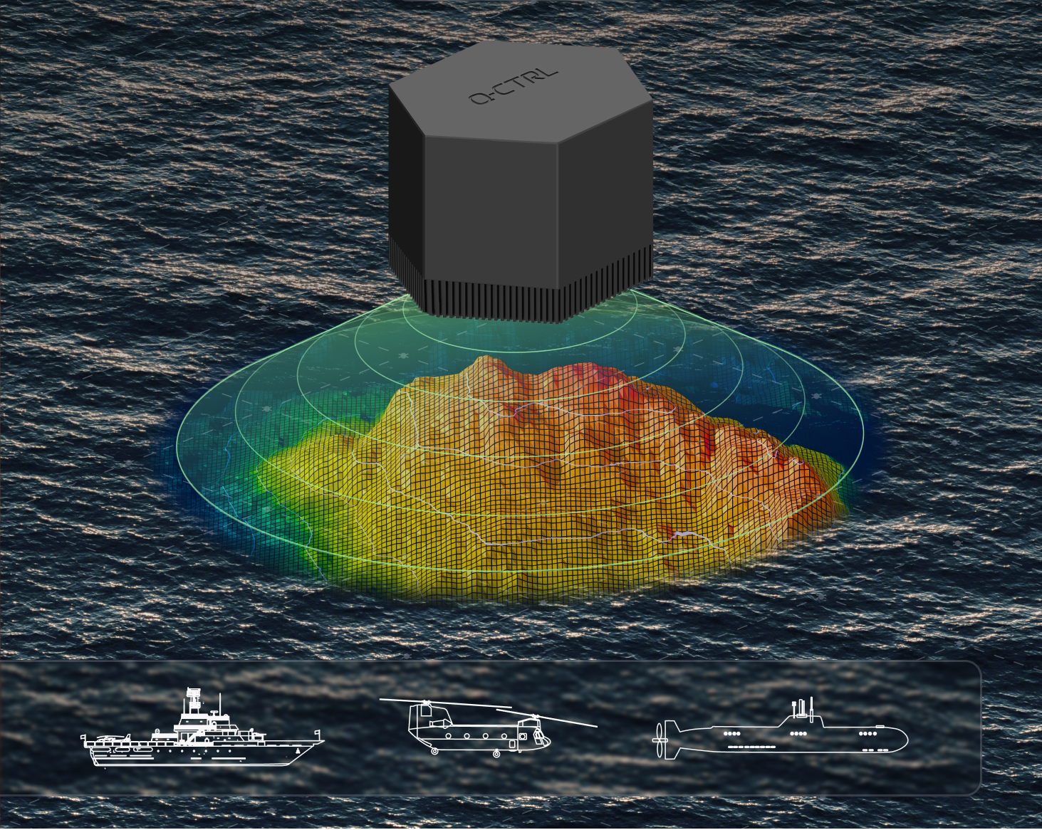
A software-ruggedized quantum navigation system was chosen as one of The Best Inventions of 2025 by TIME magazine.
Ironstone Opal by Q-CTRL has been field-validated in air, land and maritime trials. It provides a solution to GPS denial, which has become an increasing danger in conflict zones and recently threatened a plane carrying European Commission president Ursula von der Leyen. Q-CTRL is based in Sydney, Australia.
Ironstone Opal leverages quantum sensors – stabilized using software – to provide navigation immune to the kinds of interference plaguing commercial aviation, shipping and defense operations.
In airborne trials, Ironstone Opal enabled GPS-free navigation with an accuracy up to 111 times better than the best conventional GPS alternative, even under highly dynamic maneuvers. It delivered GPS-like positioning accuracy down to just 4 meters over flights up to 700 kilometers long.
Most recently, Ironstone Opal operated continuously for more than 144 hours on an Australian Navy vessel, the MV Sycamore, trialling gravimetric navigation capabilities.
“In today’s sophisticated threat environment — marked by jamming, GPS denial, and spoofing — quantum sensing offers a strategic advantage delivering resilient and precise capabilities where traditional systems fall short,” said Jonathan Green, Chief Technology Officer, Northrop Grumman Mission Systems. “As a leader in quantum technology, Northrop Grumman supports innovators like Q-CTRL in advancing the quantum industry to enhance national security through cutting edge innovation.”
Each year, TIME recognizes 300 products, software and services that are changing the world, including scientific or technological breakthroughs and innovations that make life easier and more sustainable. Ironstone Opal was identified through research from TIME’s global network of reporters and expert contributors based on key evaluation factors like originality, efficacy, ambition and impact.
The Key to Ironstone Opal
Ironstone Opal’s quantum sensors detect tiny, otherwise imperceptible signals from Earth’s structure that serve as gravimetric or magnetic “landmarks” for navigation, which are then compared with geophysical maps for precise positioning. Q-CTRL’s proprietary software-ruggedization hardens these quantum sensors for operation in the real world, allowing resilient performance in demanding environments.
The system can function as a robust backup for GPS on both crewed and uncrewed defense platforms, as well as in commercial settings. More than 1,000 commercial flights per day are affected by GPS denial, and many key players in the aerospace industry, including Airbus, are looking into quantum-assured navigation technologies as a solution.
TIME’s recognition of Ironstone Opal follows August’s news that DARPA awarded Q-CTRL two contracts totalling $24.4 million USD to develop quantum sensors for navigation on defense platforms. Also, in March, the Department of Defense’s Innovation Unit (DIU) awarded a contract to Lockheed Martin and Q-CTRL to develop a quantum-enabled inertial navigation system.
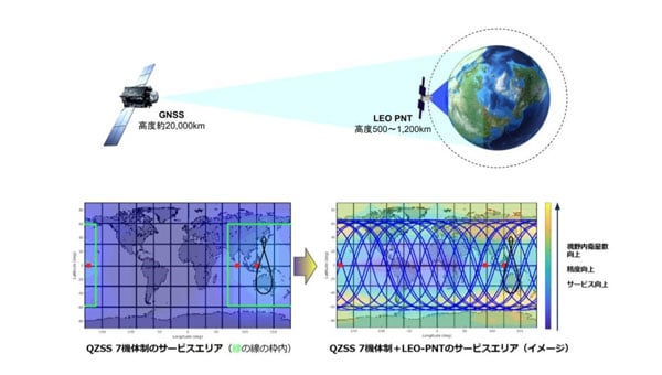
Japan Aerospace Exploration Agency (JAXA) has selected ArkEdge Space to develop a satellite positioning system designed to complement existing GNSS.
The company signed a contract begin the “Study of Elemental Technologies and Related Systems for Low-Earth Orbit Positioning Satellite Systems,” (Dedicated LEO-PNT). ArcEdge Space, led by CEO Takayoshi Fukuyo, provides solutions for microsatellite constellation planning, design, mass production and operation.
The LEO-PNT satellite system uses small satellites orbiting at altitudes between 500 km and 1,200 km to provide high-intensity, high-precision positioning information globally. Traditional GNSS satellites orbit at approximately 20,000 km.
Conventional GNSS technology faces growing threats from jamming and spoofing attacks because weak signals reach Earth’s surface. The LEO-PNT system’s high-intensity positioning signals seek to address these vulnerabilities.
The project builds on JAXA’s feasibility study conducted from October 2024 to March 2025. Researchers will examine technologies and systems for providing robust position and time information to ground users as an alternative to GNSS.
The system’s main feature is GNSS-independent service that can operate when existing systems are disrupted or jammed. Engineers will study transmitting LEO-PNT signals across C, S and L frequency bands, including C1 band (5010-5030 MHz) and C2-4 band (5030-5250 MHz).
Project Details
The study runs from September 2025 to March 2026 and includes signal design, reception technology research and system studies for GNSS-independent LEO-PNT systems.
Key Advantages
High intensity: Lower orbital altitude enables stronger positioning signals that resist attenuation and interference.
High precision: Rapid changes in satellite line-of-sight vectors allow faster positioning convergence, supporting applications like autonomous driving and precision agriculture.
Global coverage: Satellites in LEO can extend services currently limited to QZSS coverage, such as MADOCA-PPP.
ArkEdge Space said the technology will contribute to highly automated societies and a safer future.
Over time, GPS dependencies have become deeply embedded in much of the nation’s critical infrastructure, as shown in Figure 1 — from emergency services and transportation systems to critical manufacturing and logistics operations. For the past 20 years, however, efforts to protect these assets with a true backup system have stalled, despite the establishment of the U.S. Space-Based Positioning, Navigation and Timing (PNT) Policy in December 2004.
With the recent Notice of Inquiry from the U.S. Federal Communications Commission (FCC), an updated list of technological options is now on the table. However, most would require building new infrastructure or rely on quantum-based technologies that are still years away from being practical or available.
U.S. GPS Efforts Separating
Since its inception in 1977, GPS has drawn from a single technology to serve civil and military sectors. Now, with space — particularly satellites — becoming physically contested in wartime scenarios, the military is embarking on its own approach. This includes pairing GPS with military- grade receivers to improve service and protection for the global GPS layer. And two new layers are being developed as part of a multi-layer approach, deemed the “regional” GPS layer (i.e., per country) and the “local” GPS layer (i.e., per metro).
Yet, with this new system — although supporting modular, open-systems integration — the Department of Defense (DOD) is now distancing itself from other future endeavors, including supporting civil critical infrastructure. The future DOD PNT system will not follow the same path to civil/military use as was taken by GPS. The PNT capabilities employed by the DOD as such will be increasingly classified. The civil effort has not only been left to fend for itself, but it also has been tragically fragmented across many federal departments and agencies. We can only hope the recent FCC focus will help to solidify the civil GPS efforts.
Doors Open for New Solutions
The new orientation of the civil approach opens the door to significant focus on local and regional GPS services. Specifically, a new approach is based on data from the Earth’s “RF geospatial layer,” where geospatial is “relating to or denoting data that is associated with a particular location.” This layer’s data is about available RF signals, which can be used to derive the location of a particular end device anywhere in the blanket of signals. Devices using this new approach will be unencumbered by the intricacies and costs of satellite technology or having to be joint solutions required to meet military standards.
This also opens the door to the power of solutions available through consortia, which can tap into an order of magnitude more benefits through hearty partnerships. All of which also leads to the much-needed speed-to-market.
The Biggest Advantage
In the U.S., more than 110,000 towers transmit a variety of RF signals available to derive PNT. These towers provide a wide range of three-tower geometries needed for PNT calculations and enable strong resiliency (as an adversary cannot disable them all).
Two systems, in particular, are worthy of close consideration. The broadcast industry’s proposed Broadcast Positioning System (BPS) uses ATSC 3.0 infrastructure along with the existing MerlinTPS adaptive RF signal system. Both these systems take advantage of existing RF infrastructure prevalent in most developed and developing countries.
Don’t Fall Into the eLoran Trap
eLoran has been suggested by some as a viable alternative used for deriving PNT. However, this technology has notable shortcomings. The portion of the RF band it uses has several limitations. For example, eLoran is based on a 100 kHz signal, a low-frequency band that is highly susceptible to atmospheric noise.
Although some propose the use of existing AM towers for the eLoran signal, most are ~300 ft, of which eLoran tends to operate with 1600 ft towers. Attempts to operate eLoran using these shorter towers will make for reduced efficiency. Another misconception is about the proposed use of existing AM tower guidewires for transmission. At these wavelengths, that would restrict the towers to be 900 miles apart, having an impact on maintenance.
eLoran would require building new infrastructure for U.S. deployment, including 12 new towers and transmitters. The number of installations requiring significant maintenance and this low number can be taken out in physical warfare.
The eLoran system requires tight synchronization of the signals between each of its towers and the national epoch, requiring additional infrastructure with its attendant maintenance. eLoran supporting position accuracy is rated at 10 m to 20 m CEP, which is not within the FCC requirement of less than 3 m CEP.
Timing accuracy is +/- 50 ns, which meets today’s precision needs, although it is quickly becoming inadequate as needs in the precision timing market continue to increase.
Finally, the eLoran service is transmitted on one known frequency and in a published format, making it more vulnerable to jamming.
GPS RF Systems Pack a Punch
Given the issues associated with eLoran, other technologies must be considered. One such technology is available today and provided by a commercial company, MerlinTPS, which can transfer market-available, precise timing down to +/- 10ns. Such as precise timing provided by another commercial entity, Hoptroff, for example. Both companies currently provide the necessary components of a viable terrestrial GPS.
As a consortium, MerlinTPS/Hoptroff could deliver precise timing wirelessly to broadcast TV towers for BPS, while eliminating the need for signal conditioning and additional synchronization equipment at each tower, or any other related infrastructure.
MerlinTPS combined with BPS could provide all GPS services for primary and backup (not just timing). MerlinTPS can also fill in services for BPS edge cases having poor geometries. These services include portable and mobile devices. MerlinTPS is also able to handle both the enterprise and civil approaches similarly.
New open doors create freedom to quickly address the urgent national security need for reliable, alternative PNT. The consortium approach, adding commercially available technology to the broadcast infrastructure, allows for collaborative development while preserving individual market opportunities, making it an attractive proposition for all participants.
In its pursuit of strengthening European resilience in navigation, the European Space Agency (ESA) took part in Jammertest. Jammertest 2025 brought together 360 participants from 120 organisations across more than 20 countries, spanning academia, industry and governmental institutions.
Incidents of deliberate GNSS interference are on the rise, wih attacks happening daily worldwide. Disruptions threaten safe operations of energy grids, banking infrastructure, emergency transportation and civil aviation, with an outage potentially costing billions of euros daily for Europe.
Bleik on the island of Andøya offered a suitable setting for Jammerfest. (Image: ESA)
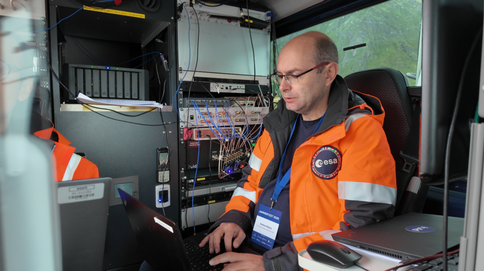
Jammertest. In a complex coordination exercise among seven Norwegian public authorities and facilitator Testnor, Jammertest organisers broadcast real satellite navigation interference for participants to observe how their equipment (on vehicles, drones, aircrafts, helicopters and vessels responds.
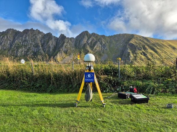
At nearly 70 degrees North and 300 km inside the Arctic Circle, the small village of Bleik on the island of Andøya offers the ideal setting for Jammertest. To the east, towering mountains act as natural barriers that contain disruptive signals, minimising their impact on civil society. To the west, its open coastline allows signals to be transmitted over the sea, supporting maritime participants in addition to air and land users.
The event’s test catalogue is extensive. Organisers simulate everything from simple handheld jamming to complex multi-source attacks launched from several locations simultaneously, including from mountaintops. “The goal is that every receiver is knocked out at some point during the campaign,” explains Tomas Levin, senior principal engineer at Norwegian Public Roads Administration and head of Jammertest.
“At Jammertest, the full GNSS chain sits along a table, from chip manufacturers to those developing the algorithms that run on them, to the companies building products around those chips and the ones integrating these products into larger systems,” Levin said.
ESA’s navigation and telecommunications testbed vehicles are custom-built mobile test platforms operated by ESA’s Navigation Laboratory to support test campaigns for navigation and telecommunications services, most notably Europe’s Galileo constellation. (Photo: ESA)
ESA engineers arrived with several missions. As in previous years, the team tested the robustness of EGNOS and Galileo signals when picked by a range of antennas, from simple mass-market ones found in smartphones to military-grade antennas, both stationary and mounted on a moving van.
A key objective was to test the performance of novel receiver technologies developed under various ESA programs, comparing them to current technologies. The team also tested equipment provided by industrial partners under ESA’s Third-Party services.
More than 100 TB of data were recorded and will support internal research. Moreover, these data can now be replayed at the ESA Navigation Laboratory, allowing industry to analyse how new equipment responds to real-world interference scenarios. (If you are interested in using ESA’s NavLab testing and consultancy services, fill out the contact form on the Consultancy and Testing page).
Finally, ESA also oversaw tests of new EGNOS ground receivers being developed by European industry under Horizon2020 and Horizon Europe programmes. These receivers aim to improve the system’s robustness in its next generation.
A multi-beam satellite navigation antenna test. (Photo: ESA)
Several projects tested at Jammertest by other participants were funded through NAVISP, highlighting the agency’s role in fostering innovation across the GNSS ecosystem.
“Jammertest is a unique opportunity,” concludes Derambure. “Here we have the edge of technology, the edge of testing scenarios. There is nowhere else where we can test this material in real conditions. I believe Jammertest will become a mandatory step for any new satellite navigation receiver technology.”
Developed by the European Union, Galileo is an independent, global, satellite-based navigation system that provides a range of services. Among its most significant advancements is the Galileo High Accuracy Service (HAS), which aims to offer free, high-precision positioning to users worldwide. This article explores Galileo HAS, covering its history, architecture, implementation phases, performance, limitations, and future prospects.
What is the Galileo High Accuracy Service?
Galileo HASis a precision augmentation service leveraging precise point positioning (PPP) to provide corrections to GNSS signals, aiming at a positioning accuracy of less than 20 cm horizontally and 40 cm vertically. Unlike the traditional real-time kinematic (RTK) method, which depends on local reference stations, HASdelivers corrections globally via Galileo satellites using the E6-B signal, as well as over the Internet. The service provides corrections for measurements on multiple frequencies across both Galileo and GPS constellations, enhancing real-time positioning performance.
The concept of a high-accuracy service for Galileo was driven by growing demand for decimeter-level accuracy in applications such as precision agriculture and autonomous vehicles. Initially envisioned as a paid service under the Galileo Commercial Service, feasibility studies in 2014 confirmed its potential. In 2018, the European Commission decided to offer HASfree of charge.
In the Galileo HASspecifications, two Service Levels are defined. Service Level 1 with global availability and the enhanced Service Level 2 for the European Coverage Area. The Galileo HASroadmap consists of three phases: Phase 0 (testing and experimentation), Phase 1 (Initial Service), and Phase 2 (Full Service). After extensive internal testing, Phase 1 was officially launched in January 2023, marking a significant milestone in Galileo’s evolution as a leading GNSS provider. Phase 2 is currently in development and expected to launch in the near future.
Technical Components
Galileo HASis designed with several key components that enable its high-precision capabilities. One of the most critical aspects involves orbit and clock corrections. These corrections compensate for inaccuracies in satellite orbital positions and clock errors, which are major sources of positioning errors in standard GNSS. Another essential element of HAS is the provision of signal bias corrections to enable precise carrier phase ambiguity resolution, which in turn greatly improves positioning accuracy. In the current Initial Service (Phase 1), Service Level 1provides only code bias corrections, along with orbit and clock corrections. In Phase 2, Service Level 1 will be upgraded to include both code and phase bias corrections, while Service Level 2will further add atmospheric (ionospheric and tropospheric) corrections for the European Coverage Area.
Capable GNSS receivers decode the high-accuracy corrections broadcast on the E6-B channel for Galileo (E1, E5a, E5b, E5, AltBOC, E6) and GPS (L1, L2, L5) signals and apply them via algorithms to enhance positioning solutions. This refines raw measurements to reduce errors, providing decimeter-level accuracy for use in fields rangiranging from ecological surveys to city infrastructure management and routine mapping tasks.
In addition to satellite broadcasts, the corrections are also made available over the Internet via the NTRIP protocol, providing an alternative access method for users with network connectivity. Notably, receiving HAS corrections via NTRIP eliminates the need for a receiver with E6-B capability, but the receiver still needs to implement the PPP algorithm to process the corrections.
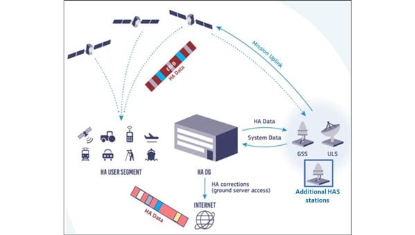
Architecture
The Galileo HASrelies on the robust infrastructure already established within the Galileo system. At the foundation of this network are the Galileo Sensor Stations (GSS), a global network of 15 monitoring stations (according to the latest updates). These stations play a vital role by continuously collecting GNSS measurements, which serve as the raw data needed to generate precise corrections. The collected data are then processed by the High Accuracy Data Generator (HADG). This system analyzes the GSSinput and produces high-precision corrections for both Galileo and GPS signals. Once the corrections are prepared, they are transferred to Uplink Stations (ULS), which transmit the correction data to the Galileo satellites for distribution via Signal-in-Space, or to an NTRIP caster for distribution over the Internet. In the case of Signal-in-Space distribution, the Galileo satellites themselves serve as the delivery mechanism to users worldwide, broadcasting the corrections globally via the E6-B signal.
The HAS is being rolled out in three phases, ensuring progressive development and refinement:
Phase 0 (2020–2022): Internal Testing
Focused on validating the feasibility of broadcasting HAS corrections via the E6-B signal.
Tests involved internal and external stakeholders, with feedback used to refine the service.
Phase 1 (January 2023–Present): Initial Service
Declared operational on January 24, 2023, Phase 1 provides Service Level 1 with global coverage, though with reduced performance compared with the enhanced Service Level 1 expected in Full Service (Phase 2).
Current corrections include orbits, clocks, and code biases.
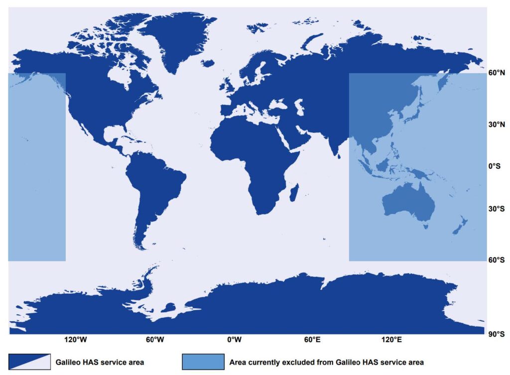
The service area excludes certain regions (e.g., parts of the Pacific and Australia) because of infrastructure limitations.
Convergence time is specified as <300 seconds (Service Level 1) or <100 second (Service Level 2), with horizontal accuracy <20 cm and vertical accuracy <40 cm under optimal conditions. Currently, accuracy <20 cm may be achieved with a convergence time up to 60 minutes, owing to the lack of phase bias and atmospheric corrections.
Phase 2 (Future): Full Operational Capability
Will provide full Service Level 1 performance globally with horizontal accuracy <20 cm and vertical accuracy <40 cm, adding phase bias corrections for faster convergence <300 seconds.
Will introduce Service Level 2 for regional coverage in Europe with horizontal accuracy <20 cm and vertical accuracy <40 cm, adding phase bias and atmospheric corrections for faster convergence (<100 seconds).
Will include data authentication and enhanced infrastructure for improved reliability and coverage.
Challenges and Limitations
The current capabilities of Galileo HASare constrained by several limitations, which are expected to diminish as the system evolves. Global coverage is not yet fully established, with parts of the Pacific region and Australia remaining outside the service area. While users can receive HAScorrections anywhere in the world, the official performance specifications apply only within the service boundaries. However, even within the service area, achieving the specified accuracy presently requires long convergence times, limiting applicability in scenarios that demand rapid solutions. Convergence time is expected to decrease significantly in Phase 2, when phase bias and atmospheric corrections are introduced.
As of 2025, relatively few commercial receivers support HAScorrections via E6-B, with availability concentrated in professional and industrial receivers. The lack of integration into mass-market devices limits broader adoption, reflecting both the technology’s ongoing development and the additional hardware complexity required to receive HAScorrections.
Finally, while decimeter-level corrections are sufficient for a wide range of applications, many professional domains, such as surveying, demand cm-level accuracy. Even at Full Service, HASwill not provide this level of precision, meaning that certain fields will continue to rely on RTK. However, considering that most RTK vendors require a paid subscription or charge per hour, HAScan still provide great value to surveyors and other professionals through its use in preliminary work or applications where cm-level accuracy is not critical, offering decent accuracy free of charge.
The Galileo constellation was recently reinforced with satellites 31 and 32, which became operational in January 2025, while the ground segment underwent major upgrades in 2024. Despite these improvements, Phase 1 (Initial Service)remains the only operational HAS capability. As of September 2025, Phase 2remains in active development. In January 2025, it was announced that the European Union Agency for the Space Programme (EUSPA) awarded GMV a 45-month, €12 million contract to develop an enhanced HADGthat will support enhanced Service Level 1 globally and Service Level 2 for Europe. The contract’s duration provides an indication of the anticipated timeline for completion.
An inquiry regarding the timeline for Galileo HASService Level 2 (Phase 2) was submitted to the European GNSS Service Centre (GSC) Helpdesk. Their reply stated that the schedule is not available at this time and will be announced through GSC channels once released.
Wider adoption is anticipated as more GNSS receivers capable of receiving and decoding the E6-B signal to process HAScorrections become available, enabling sectors such as autonomous transportation, fleet management, and smart agriculture to capitalize on improved performance. Adoption is also expected to accelerate when Galileo HAS reaches Full Operational Capability with the launch of Phase 2, which will reduce convergence times and broaden the system’s applicability.
Ultimately, Galileo HASis positioned to become a cornerstone of high-accuracy GNSS, democratizing access to professional-grade precision.
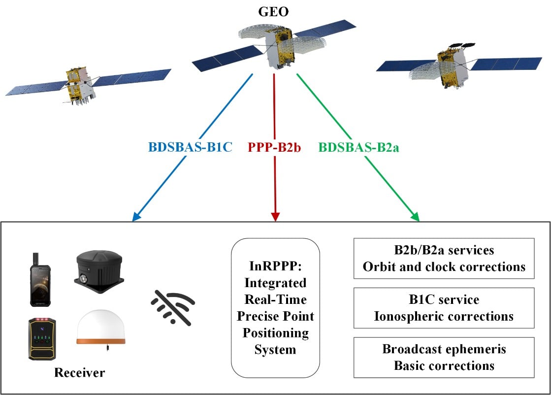
The development of an Integrated Real-Time Precise Point Positioning (InRPPP) system leveraging BeiDou Navigation Satellite System (BDS) B2b, B2a, and B1C services has significantly enhanced satellite-based positioning accuracy.
By resiliently utilizing these augmentation messages, the InRPPP system corrects satellite orbit and clock errors and mitigates ionospheric delays, outperforming traditional methods. Experimental results from both static and kinematic conditions demonstrate superior performance, showing improved positioning accuracy, faster convergence times, and greater stability in challenging environments. This breakthrough offers potential for applications in real-time navigation, precision positioning, and disaster monitoring, with a broader impact on industries requiring reliable and continuous positioning data.
The implications of the InRPPP system are vast, with applications spanning multiple sectors that depend on high-precision satellite navigation.
Satellite-based navigation systems, like the Real-Time Precise Point Positioning (RTPPP), are crucial for many industries that require accurate location data. However, these systems face limitations in areas with weak Internet connectivity or signal interference. BeiDou’s satellite augmentation services, namely B2b, B2a, and B1C, have emerged as a promising solution.
Yet, integrating these services into one cohesive system for optimal performance remained unexplored. This study pioneers the Integrated InRPPP system, which integrates all three services including correcting satellite clock, orbit errors, and ionospheric delays, unlocking new levels of positioning accuracy. The results from this research address critical limitations in current satellite-based positioning technology, setting the stage for real-world applications in complex environments.
In a 2025 Satellite Navigation publication (DOI: 10.1186/s43020-025-00172-x), researchers from the State Key Laboratory of Geo-Information Engineering and Key Laboratory of Surveying and Mapping Science and Geospatial Information Technology of MNR, State Key Laboratory of Spatial Datum, and Hohai University introduced the InRPPP system, a new approach that leverages the B2b, B2a, and B1C services of the BDS.
Scenes of the static experiment. The left and right panels denote the west and south sides of the station. (Photos: Study authors)
By combining these services, the InRPPP system corrects satellite orbit and clock errors while mitigating ionospheric delays. With enhanced accuracy, stability, and faster convergence times, this system has the potential to transform satellite-based positioning, offering more reliable and continuous service in real-time applications, especially in environments where traditional positioning systems struggle to perform.
The InRPPP system brings a new level of precision to satellite navigation by combining the best of BeiDou’s B2b, B2a, and B1C services. Through this integration, the system corrects satellite orbit and clock errors with B2b and B2a services, while B1C handles ionospheric delays. This resilient approach allows the system to deliver superior performance, even in high-occlusion or remote environments. The static experiments showed the InRPPP system surpasses other methods, with a 59.6% improvement in positioning accuracy and a 65.9% reduction in convergence time compared to using B2b, B2a, or B1C individually.
In dynamic conditions, the system demonstrated enhanced stability and reduced signal interruptions, achieving up to a 34.3% improvement in accuracy. The integration of these services increases the number of visible satellites, enhancing the Position Dilution of Precision (PDOP) values and ensuring better satellite geometry. This integrated approach not only improves accuracy but also ensures continuous, reliable solutions, making it a game-changer for fields like geodesy, navigation, and disaster monitoring.
Academician Yuanxi Yang of the Chinese Academy of Sciences, the lead researcher behind the InRPPP system, remarked, “The ability to integrate multiple BeiDou augmentation services into a single real-time positioning system represents a major breakthrough. By leveraging B2b, B2a, and B1C, our system offers a more reliable and accurate solution than anything available today. In both static and kinematic tests, the InRPPP system has outperformed traditional positioning methods, demonstrating its robustness and resilience in environments where signal conditions are far from ideal. This system is already applied in real applications and has potential to reshape industries reliant on satellite navigation and positioning.”
The implications of the InRPPP system are vast, with applications spanning multiple sectors that depend on high-precision satellite navigation. From autonomous vehicles and precision agriculture to disaster management and geospatial services, the enhanced accuracy and stability offered by InRPPP can support real-time decision-making in critical environments. This system also promises to improve the resilience of navigation systems in regions with poor satellite visibility or signal interference. As technology advances, the InRPPP system could pave the way for even more robust solutions, advancing global sustainability goals and improving disaster response capabilities by offering uninterrupted, reliable positioning data.
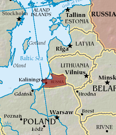
An A330 airplane carrying Spanish Defence Minister Margarita Robles experienced GPS interference while flying over Kalingrad, Russia, reports EU Today. The news outlet cites Spanish newspaper El Mundo as its source.
Robles was flying to in an aircraft belonging to the Spanish Air and Space Force. It was is “subjected to an attempt to throw it off course using GPS” over Kaliningrad as Robles was travelling to the Šiauliai air base in Lithuania on Sept. 24.
The pilot said incidents attempting to disorient pilots have been common for both commercial and military flights over Kaliningrad. Becausee this was a military craft, the plane was receiving instructions from a military satellite and the attempt failed.
A coalition of 14 major industry associations has called on the departments of Defense and Transportation to address increasing threats from GPS signal jamming and spoofing that are affecting civilian operations beyond traditional conflict zones.
The letter, signed by organizations including the GPS Innovation Alliance (GPSIA), Aircraft Electronics Association, Airlines for America and the U.S. Chamber of Commerce, was sent to Defense Secretary Pete Hegseth and Transportation Secretary Sean Duffy, outlining concerns about GPS signal interference. The letter warns that such interference is expanding beyond military conflict zones to affect civilian transportation and commerce operations in international airspace and waters.
The coalition represents industries that collectively contribute significant portions to the U.S. economy. The aviation system accounted for 5% of U.S. GDP in 2024, totaling $1.45 trillion, while ports and maritime operations contributed $2.9 trillion, nearly 10% of GDP. GPS technology has generated more than $1.4 trillion for the U.S. economy since its introduction, with more than 6 billion GPS-enabled devices in use worldwide.
The organizations are seeking coordinated action from the Trump administration to modernize GPS infrastructure and enhance its resilience against interference. The coalition has indicated its willingness to work with federal agencies on addressing what it describes as challenges to national security, public safety and economic prosperity.
System Vulnerabilities
Despite GPS maintaining a 99.99% availability rate with no recorded outages since 1993, the system faces several challenges. On-orbit satellites operate years beyond their intended design life, ground system upgrades have been delayed, and the system lacks counter-spoofing capabilities.
The coalition emphasizes that GPS serves as a foundation for modern defense, aviation, maritime operations and commercial activities. Transportation industry officials note their sector’s role as a key partner in U.S. military logistics operations.
“GPS is one of the most important innovations of the modern era, underpinning national security, critical infrastructure such as transportation, and commerce,” said Lisa Dyer, Executive Director of the GPS Innovation Alliance. “The Trump administration’s approach to “getting stuff done” is what this nation needs to finally achieve a modern GPS that is resilient to jamming and spoofing. The President’s leadership can also deter further harmful interference – actions that will benefit most critical industries that are delivering goods and services around the world and transporting passengers safely to their destinations.”
The GPSIA recommendations call for executive branch agencies to:
Accelerate the procurement and launch of modern GPS satellites and include anti-jamming and anti-spoofing technology upgrades in GPSground systems. Prepare a program plan that ensures GPS is technologically more advanced than China’s BeiDou and Europe’s Galileo GPS-like systems.
Strengthen enforcement and coordination across the U.S. government to rapidly identify and respond to interference events and crack down on illegal sales and use of jamming devices.
Streamline regulatory and certification processes to accelerate adoption of advanced technologies such as jam- and spoof-resistant antennas, modern GPS signals, and anti-spoofing signal authentication in airframes, receivers and devices.
Deter interference through public statements and diplomatic engagement, making clear the United States will not tolerate harmful jamming and spoofing outside conflict zones that risks public safety and impedes commerce.
“These are concrete, achievable actions that, if pursued, will ensure the integrity, continuity, availability, and resiliency of GPS. This approach also offers the commercial position, navigation, and timing industry time to mature and deploy their technologies so that they can meet the high regulatory bar that is appropriately set for public safety applications,” Dyer said.
Maxar Intelligence is partnering with Taiwan’s Aerospace Industrial Development Corporation (AIDC) to deploy the Maxar Raptor software suite across Taiwan’s unmanned aerial vehicle (UAV) industry. The move will help the country accelerate the resilience and reliability of autonomous systems in GPS- and GNSS-denied environments.
Raptor is a vision-based software suite that enables autonomous drones to navigate precisely and extract accurate ground coordinates in the absence of GPS. Designed for lightweight integration with any autonomous platform, Raptor products use a drone’s native camera and Maxar’s 100 million-plus sq km of global 3D terrain data to help the platform navigate with extreme precision and extract accurate ground coordinates in real-time without GPS. Raptor can operate at night and in low-altitude flight operations without the need for any additional hardware.
The partnership follows a successful field demonstration of Raptor software in Taiwan earlier this year, in which the test platform was able to maintain precise navigation under GPS-denied conditions using only its native camera and Maxar’s software.
The test platform was able to maintain precise navigation under GPS-denied conditions using only its native camera and Maxar’s software.
“Taiwan is rapidly building one of the most advanced UAV industries in the world, and AIDC is one of the companies leading the charge,” said Anders Linder, general manager, International Government at Maxar Intelligence. “Taiwanese UAV manufacturers are acutely aware of the importance of building resilience against GPS jamming, and AIDC has validated the unique capabilities of our Raptor software. By combining our geospatial intelligence with AIDC’s aerospace expertise, we’ll help Taiwan’s UAV industry maintain its forward momentum, accelerating autonomy across warfighting, humanitarian, and commercial operations.”
AIDC will drive the adoption of Raptor across Taiwan’s UAV supply chain and promote use of the software across the Taiwan Excellence Drone International Business Opportunity Alliance (TEDIBOA), an organization that AIDC chairs.
“This collaboration opens a new chapter for precision vision-based positioning in Taiwan’s UAV sector,” said AIDC President Chin-Ping Tsao. “We will jointly build a Taiwan-focused integration and testing center, highlight GPS-jamming resilience as a core differentiator, and unlock opportunities across Taiwan and the broader Asia market — advancing both defense resilience and commercial value.”
Safran Electronics & Defense‘s Skydel GNSS simulation platform is now fully certified to support simulation of Xona Space Systems’ low-Earth orbit positioning, navigation and timing (LEO-PNT) signal, Pulsar.
According to the companies, this certification is the culmination of a rigorous multi-phase validation program jointly led by Safran and Xona engineering teams. It underscores Safran’s commitment to advancing robust, high-fidelity testing for next-generation LEO-PNT services. With this milestone, engineers can now use Skydel to evaluate Pulsar’s performance in environments that reflect real-world complexity, interference and operational demands.
Skydel now simulates Xona’s Pulsar X1 signals, delivering centimeter-level precision, 100x signal strength and enhanced resilience — capabilities that Pulsar will soon bring to orbit.
“With Skydel-powered simulators certified for Pulsar X1, our customers have more possibilities than ever,” said Pierre-Marie Le Veel, program director of PNT simulation at Safran Electronics & Defense. “They can test LEO and legacy constellations side by side, introduce complex interference, and explore entirely new scenario combinations — all from a single, flexible platform. This is a major step forward in enabling engineers to push the boundaries of GNSS testing.”
Beyond accuracy, Skydel enables advanced resilience testing, including jamming, spoofing and other NAVWAR threats. Its modular, future-ready architecture ensures seamless integration of new Pulsar signal types and constellation updates, offering the agility needed to keep pace with the evolving LEO PNT landscape and demands for trusted, high-integrity PNT.
“Validation is the bridge between innovation and trust,” said Tyler Reid, CTO of Xona. “By replicating Pulsar at full fidelity, Skydel empowers engineers to design and validate solutions for the most demanding navigation and timing challenges — without waiting for on-orbit availability.”
Skydel’s certified Pulsar simulation capability is available now to partners and customers worldwide.
Quectel Wireless Solutions has introduced four new GNSS antennas. The new antennas include:
The YFGD000AA high-precision, low-profile antenna which covers all GNSS bands
The YFGD000BA, optimized for triple-band solutions in GNSS L1, L2 and L5 bands
The YFGN000H1AC high-precision, lightweight antenna that again covers all GNSS bands
The YEGT010W1AM, designed for general-purpose reception in non-precision applications.
Quectel’s triple-band and all-band antennas are built to maximize performance with the latest generation of RTK GNSS modules. These include the LC29H dual-band module, designed for cost-sensitive yet precision-critical applications; the LG290P industrial-grade module, delivering centimetre-level accuracy with RTK fix times under five seconds; and the flagship LG580P, which adds L6 support and dual-antenna heading, making it suitable for ADAS, robotics and autonomous systems.
Complementing the hardware, Quectel’s global RTK correction service leverages a network of more than 21,000 base stations to provide consistent centimeter-level accuracy worldwide, ensuring seamless coverage across Asia, Europe and North America, and enabling scalability for industries such as agriculture, logistics and automotive.
The YFGD000AA is a high-performance multi-band active GNSS antenna designed for professional applications requiring ultra-precise positioning across L1, L2, L5, L6 and L-Band frequencies (1164–1300 MHz and 1525–1606 MHz). With dimensions of 78.6mm x 75.6mm x 16.2mm and a screw mounting, the antenna is suitable for vehicular or fixed installations and operates in the -40 °C to +85 °C temperature range. Combining exceptional signal sensitivity with rugged durability, this antenna is engineered for mission-critical deployments in autonomous systems, geodetic surveying and high-accuracy navigation. It is RoHS, REACH and POPS compliant.
The YFGD000BA offers similar capabilities to the YFGD000AA but has been developed to support professional applications with ultra-precise positioning needs across L1, L2 and L5 bands (1164–1238 MHz and 1559–1606 MHz). It shares dimensions, operating temperature range and mounting options with the YFGD000AA and is also RoHS, REACH and POPs compliant. Both the YFGD000AA and YFGD000BA can support high-precision RTK despite their compact size.
The YFGN000H1AC is a high-precision antenna with a higher profile than the YFGD000AA and YFGD000BA but with greater performance and lighter weight of 62g. The antenna covers all GNSS bands, ensuring worldwide compatibility. It delivers 35 ±4 dB gain with a low noise figure of ≤4 dB, making it suitable for weak-signal environments like urban canyons or dense foliage. With a diameter of 122mm and height of 22.5mm, the antenna features a screw mounting so it can be attached to vehicles or fixed installations. It operates in –40 °C to +85 °C temperature range and is RoHS and REACH compliant. Should customers require it, Quectel can supply enclosures to convert the antenna from an internal to external set up.
Finally, the YEGT010W1AM is a GNSS rubber external antenna with a diameter of 10.22 mm and height of 69.5 mm. This ultra-wide-band GNSS antenna provides broad coverage from 1559–1606 MHz and is terminated with an SMA male connector. With omnidirectional capability and linear polarization, YEGT010W1AM is designed for general-purpose reception in non-precision applications, especially where signal direction varies.
The terminal mount design, with a compact, rugged form factor makes it easy to install on gateways, routers or tracking devices in protected environments. Operating in the –40 °C to +85 °C temperature range, the antenna weighs 8.9g and is RoHS compliant. In addition, the antenna’s universal joint design allows customers to easily adjust the polarization direction, helping to mitigate the angle sensitivity commonly associated with linearly polarized antennas in real-world applications, therefore enhancing overall signal stability.
In addition to the antennas, Quectel provides comprehensive antenna design support services such as simulation, testing and manufacturing for custom antenna solutions to meet developers’ and designers’ specific application needs.
Quantum technologies may offer a solution to GPS jamming and spoofing, according to the University of Chicago. Already, prototypes are being tested of a suite of sensor-based techniques that do not rely on satellite signals.
GPS jamming and spoofing have emerged as growing threats in recent years, according to the Chicago Quantum Exchange, based at the university. In 2024 alone, more than 1,000 commercial flights per day were affected by GPS spoofing, especially while flying through regions like the Middle East and Eastern Europe.
During these incidents, in-flight instruments show pilots that their aircraft is flying higher or lower than they truly are or that they are miles off their actual location. In maritime settings, spoofed GPS signals have even caused ships to veer off course or run aground. These are not isolated glitches but the result of deliberate electronic warfare tactics.
Corporate partners of the Chicago Quantum Exchange, including Boeing, Infleqtion and SandboxAQ, are among those developing applications. The CQE is a hub that connects leading universities, national labs, and industry partners to advance quantum technology.
“Governments and the commercial industry are in dire need of this technology,” said Ken Devine, senior product manager for quantum navigation at SandboxAQ. “The geopolitical issues happening across the world, and the ramp up in both jamming and spoofing — Russia, Ukraine, the Middle East, Israel, Iran — everyone’s getting super disruptive, and that’s not going to go away anytime soon. Everyone is saying, ‘We basically need this yesterday.’”
In May 2023, SandboxAQ completed the first of many flight tests for the United States Air Force and its commercial aviation partners, including two major Air Force exercises that year.
In 2024, Boeing completed the world’s first recorded flight using multiple quantum navigation systems, testing the ability of these sensors to navigate across the central U.S. for four hours without GPS.
The Boeing test incorporated two different technologies. The first is a magnetic field-based navigation system called AQNav from SandboxAQ, It uses map matching, though the map that they use is of the Earth’s crustal magnetic field rather than terrain. Infleqtion is investigating both techniques. The second is an inertial navigation system from quantum sensing technology company AOSense.
Jay Lowell, principal senior technical fellow at Boeing, said it was vital to consider “whether and how” the different technologies could be used together. “Maybe that means a tradeoff of performance between sensors in moments where one struggles and the other’s strong,” Lowell said. “Fundamentally, it means we just need to understand whether their combined data is better than either one alone.”
Detecting tiny changes
Inertial navigation depends on accelerometers and gyroscopes — which respectively measure acceleration and rotation — to measure movement. An inertial sensor tracks how an object moves from a known starting point by recording changes in its speed and direction.
While basic accelerometers are common in smartphones and fitness trackers, quantum inertial sensors can detect changes in motion down to the femtometer — less than the width of an atom — making them extraordinarily precise. Inertial sensors have applications in space-based technology, since they do not need maps or fixed points to navigate.
Infleqtion recently completed commercial flight trials of inertial-based quantum navigation in the United Kingdom and plans to conduct tests in the U.S. as well. Infleqtion’s Chicago office is also developing an AI-powered tool called SAPIENT that won first place in the U.S. Army’s xTechScalable competition.
“[SAPIENT] is focusing on the software side, taking the outputs of multiple kinds of sensors and stitching them all together with AI to provide a more robust navigation signal,” said Pranav Gokhale, general manager of computing at Infleqtion. “There is a big gap between an inertial measurement unit and a full inertial navigation system, so we’re using AI to fill that gap.”
Alternatively, magnetic navigation, or MagNav, works much like terrain-following radar, comparing real-time sensor data to a known map to pinpoint location.
But instead of elevation, the aircraft senses subtle magnetic fluctuations in the Earth’s crust — variations caused by geology, mineral deposits and even human infrastructure — and compares its measurements to a corresponding map of that field.
Scientists believe that birds can use their ability to sense the Earth’s magnetic field to navigate in a similar way. Magnetic field maps of the globe are frequently done for mineral, oil and gas surveys, as small anomalies in the field can indicate resources underground. But there are areas where high-resolution maps can be hard to come by.
“Map quality in the region you’re going to is definitely a factor that gets plugged into how well magnetic navigation can perform,” Devine said.
He identified a list of other key variables, such as the type of aircraft being used, plus its altitude and speed, as additional points of consideration for MagNav technology. At the same time, he said the importance of these tools is likely to grow as electronic warfare strategies become even more entrenched.
“We’ve validated that we can do real-time navigation with this technology,” Devine said. “And that’s huge, because the need for it is only going to increase.”