Adtran‘s Oscilloquartz synchronization platforms now support Galileo’s Open Service Navigation Message Authentication (OSNMA). OSNMA is a GNSS authentication service designed for civilian use.
By verifying that timing data originates from genuine Galileo satellites, OSNMA ensures authenticity and integrity at the point of reception. The new feature, available via firmware update for supported multi-band GNSS receivers, adds an extra layer of protection against spoofing and manipulation, empowering existing deployments to strengthen security without hardware changes or service disruption.
OSNMA support from Adtran brings a new level of GNSS security to critical infrastructure. Available for multi-band GNSS receivers in the OSA 5412, OSA 5422, OSA 5430 and OSA 5440 product lines, the feature integrates with Galileo’s Open Service, using digital signatures and TESLA chain keys to authenticate navigation data. This ensures that timing and positioning information is verified as authentic and protected against spoofing or manipulation.
Adtran’s Oscilloquartz Syncjack probing adds a second layer of defense, detecting record-and-replay attacks – also known as meaconing – by comparing GNSS signals against trusted PTP sources. This dual-layer approach helps identify subtle timing manipulations and delay attacks that traditional receivers may miss.
“From 5G and smart power grids to financial networks and data centers, bringing authentication to GNSS is a game changer for critical infrastructure,” said Gil Biran, GM of Oscilloquartz, Adtran. “By enabling our customers to defend against sophisticated threats, including meaconing, we’re helping them achieve greater timing integrity for their networks. Existing customers can access this new GNSS security feature with a simple firmware update, helping them stay protected as threats continue to evolve.”
Microchip Technology has released the TimeProvider 4500 v3 grandmaster clock (TP4500) designed to deliver sub-nanosecond accuracy for time distribution across 800 km long-haul optical transmission.
Most current deployments require GNSS at grandmaster sites, but the TP4500 enables highly resilient synchronization without relying on GNSS, providing critical infrastructure operators with complementary positioning, navigation and timing (PNT). The TP4500 is a resilient, terrestrial solution for the absence of GNSS in precise timing, alleviating physical obstruction, security and signal interference costs associated with GNSS-dependent deployments.
The TP4500 supports time reference provided by UTC(k) UTC time provided by national labs. It offers a premium capability that delivers High Accuracy Time Transfer (HA-TT) as defined by ITU-T G.8271.1/Y.1366.1 (01/2024) to meet 5 nanoseconds (ns) time delay over 800 km (equating to 500 picoseconds (ps) average per node, assuming 10 nodes), setting a new industry benchmark for accuracy.
The TP4500 system can be configured with multiple operation modes to form an end-to-end architecture known as virtual PRTC (vPRTC), capable of delivering PRTC accuracy over a long-distance optical network. vPRTC is a carrier-grade architecture for terrestrial distribution of HA-TT, which has been widely deployed in operator networks throughout the world.
TimeProvider 4500 v3 is a key steppingstone towards support of the ITU-T G.8272.2 standard, which defines a coherent network reference time clock (cnPRTC) in amendment 2 (2024). An cnPRTC architecture ensures highly accurate, resilient, and robust timekeeping throughout a telecom network. This allows stable, network-wide ePRTC time accuracy, even during periods of regional or network-wide GNSS unavailability or other failures and interruptions.
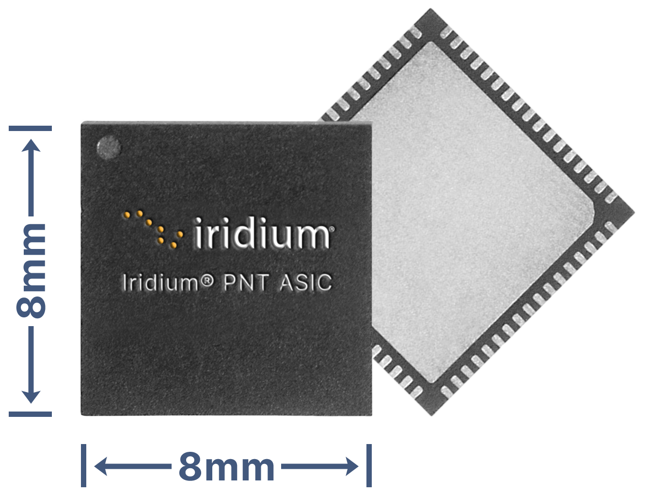
Iridium Communications Inc. has unveiled a dedicated, miniature application-specific integrated circuit (ASIC), the Iridium PNT ASIC. Engineered for seamless integration into a wide range of electronic devices, the Iridium PNT ASIC will deliver authenticated, pole-to-pole positioning, navigation and timing (PNT) data. It will provide a resilient alternative to traditional GNSS, offering protection against spoofing and jamming for consumer, industrial and government applications.
The Iridium PNT ASIC measures 8 x 8 mm and can be fit into devices ranging in size from consumer products to major infrastructure systems like power grids, transportation systems and telecom networks. When embedded in a device, the Iridium PNT ASIC receives a cryptographically secure time and location data signal from the Iridium satellite network that is 1,000 times more powerful than GPS and capable of working inside buildings. This can help GNSS-dependent applications to not only detect a problem but also maintain operations until it is resolved. The Iridium PNT ASIC will also continuously verify signal integrity, making it a suiitable alternative or primary source of PNT data.
Iridium showcased the ASIC’s capabilities during September’s Jammertest, an annual event that evaluates the resilience of GNSS and alternative PNT technologies under jamming and spoofing attacks. The Iridium PNT ASIC maintained both timing accuracy and reliable navigation during controlled exercises.
Iridium is inviting organizations to apply to participate in beta trials, and, if selected, they will receive Iridium PNT ASIC evaluation kits, enabling early integration and testing. The Iridium PNT ASIC is planned for commercial availability in mid-2026.
Position, navigation and timing (PNT) services, derived primarily from GNSS constellations, have become a critical element underpinning the global economy, with a vast range of sectors depending on these signals.
This includes coordinating financial transactions, stabilizing power grids as well as navigation, with supply chains set to become more reliant on the technology as autonomous vehicles become prevalent. However, GNSS is a vulnerable technology, with faint signals from medium-Earth orbit (MEO) satellites being susceptible to disruption.
In this article we’ll look at how both static and dynamic applications can achieve resilient PNT, with strategies and sensor fusion techniques that allow operational capability when GNSS is denied.
Seven hundred. That’s the number of GPS interference events such as jamming and spoofing that take place every single day, according to the U.S. government. And this number is increasing across North America and Western Europe, with it being especially prevalent in or near war zones.
Indeed, in August, the navigation system of a plane carrying the EU President, Ursula von de Leyen, was reportedly targeted by a GPS jamming attack as it was due to land in Bulgaria — forcing pilots to rely on paper maps. And GPS interference has been linked to the crash of Azerbaijan Airlines flight J2-8243, which was shot down on Christmas Day, 2024.
Relying on a single source for PNT is no longer a viable strategy and developing a resilient PNT ecosystem that can function in D3SOE (denied, degraded, and disrupted space operational environments) has become essential.
While navigation is the most commonly understood application of PNT, the timing component is critical in so many of the static systems we rely on — not just finance and power (as listed above) but for AI data centers, asset tracking systems and communication networks — which require precise and stable time references to ensure data integrity, and need these to be synchronized across global networks.
For such systems, the consequences of getting timing off by even the smallest amount can be seen in the 2016 decommissioning of the SVN23 GPS satellite. During this, a software error created a 13.7 microsecond anomaly across the entire constellation that, according to a UK government report caused issues with digital radio broadcasts and communication networks. The event is also seen by some as a warning for the financial sector and in particular for high-frequency trading (HFT), where trades take place in millionths and studies have suggested that a 1 ms advantage in trading applications could be worth $100 million a year to a major brokerage firm.
By subtly altering timing signals used by trading systems, malicious actors can effectively see and use market data “from the future” and enact transfers worth billions of dollars.
Similarly, a timing attack on the phasor measurement units (PMUs) used to measure real-time stress in power grids could trigger major blackouts. The effect of such an attack can be seen in 2003’s (pre-PMU) Northeast Blackout, in which a sagging power line touched tree and caused a series of cascading outages that affected 55 million people across the U.S. and Canada.
And further putting the importance of protecting PNT in context, in 2020 the U.S. defined 16 critical infrastructure sectors as part of its Executive Order 13905. Of these 14 (88%) of these are reliant on PNT for their safe operation. Going beyond the energy and finance examples above, this includes sectors like communications, transportation, and agriculture. In short, PNT resilience is essential across virtually the entire economy.
Detecting a Compromised GNSS Signal
Of course, the first stage in protecting a PNT signal is in the identification of an attack, and several techniques can be used to identify inconsistencies that point to jamming or spoofing.
These range from the analysis of the signal’s Doppler shift (transmissions from nearby terrestrial spoofer will have a near-zero Doppler shift) to techniques like RAIM (receiver autonomous integrity monitoring), which continually recalculates position while excluding one satellite each time to see if the results are consistent.
Cryptographic methods, such as Galileo’s Open Service Navigation Message Authentication (OSNMA), are also available to verify a satellite’s digital signature and confirm the data’s authenticity.
However, relying on cryptographic authentication alone still comes with risks. Notably, authenticated signals are susceptible to meaconing attacks, where a legitimate signal is recorded and replayed later to mislead a receiver. It is, however, possible to counter these attacks using a secure, out-of-band verification layer for all GNSS constellations. This involves the independent delivery of authentication data with hash authentication transmitted via encrypted L-band correction signals from geostationary (GEO) satellites.
This approach can also be retrofitted to older equipment using PNT by using an RSR transcoding device (see below).
For dynamic systems, an additional level of validation can be gained by inertial sensors, comparing their output against PNT data to detect both sudden large jumps in position and continual slight deviations that can be characteristic of a sophisticated spoofing attack.
Timing in Static Applications
The timing architecture of such systems must go beyond simply identifying a threat and validate incoming data. This requires the integration of alternative PNT sources through an intelligent sensor fusion framework. To achieve this level of resilience in a fixed location, a multi-source, zero-trust approach is necessary. This involves augmenting or replacing GNSS with a layered defense of terrestrial and alternative space-based signals that can be authenticated and trusted.
Modern PTP grandmasters utilize the latest sub-microsecond accuracy Precision Time Protocol (PTP) and the more common millisecond-range Network Time Protocol (NTP) to ensure compatibility with nearly all standard IT equipment.
High-speed 25G PTP Ethernet connections are also being implemented to support high-performance AI data centers and financial exchanges without creating data bottlenecks. To ensure continuous operation during extended GNSS outages, these systems can draw synchronization from terrestrial sources like a network PTP feed or an optional atomic caesium clock.
Furthermore, it is also possible to use encrypted L-Band signals from geostationary (GEO) satellites, such as those from Inmarsat, which create an enhanced timing service with built-in GNSS authentication and anti-spoofing features to deliver timing accuracy of sub-5 ns.
Figure 1: VIAVI’s Inertial Labs division has developed a Visual-Inertial Navigation System (VINS) that combines 3D vision aided mapping with inertial accelerometers to enable positioning in D3SOE environments — shown in prototyping stage.
Navigation Without a North Star
While static applications can utilize fixed terrestrial infrastructure for backup, dynamic systems do not have this luxury.
The inherent weakness of RF signals makes them easy to overpower through deliberate jamming by hostile actors. As such, navigation systems onboard UAVs and autonomous vehicles, as well as manned commercial and military vehicles require self-contained navigation capabilities that can function reliably when GNSS signals are compromised. This has driven significant advances in inertial navigation.
Sensors like accelerometers and gyroscopes have become a critical source for orientation and direction data that remains available at all times. The development of micro-electromechanical systems (MEMS) has been crucial, enabling the integration of inertial navigation into even the smallest systems.
These sensors aren’t an alternative to PNT satellites. By their very nature they will accumulate errors over time, with sensor bias causing drift and random-walk deviations allowing random noise in each measurement to accumulate. However, recent years have seen significant gains in their accuracy, allowing navigation to continue for short periods after GNSS data is compromised.
Combining these inertial sensors with sensor fusion techniques also allows each element in a multi sensor system (using magnetometer; and accelerometers/ gyroscopes for roll, pitch and yaw…) to be continually verified by the others for further improvements in accuracy, reducing overall level of error. Data from these IMUs can also be fused with signals from alternative satellite constellations like those in LEO.
LEO satellite signals are less accurate for timing than GNSS (around 80 ns vs. sub-15 ns) but are significantly stronger. For example, the Iridium LEO STL signal is c.1,000 times stronger than GNSS, making these signals both more resistant to jamming and harder to undertake a (successful) denial of service.
More recently, techniques using downward-facing camera to track fixed identifiable landmarks have been developed as an alternative / additional data validation method for dynamic systems.
These external sources provide absolute reference points that can be used to correct the inertial system’s calculations, dramatically improving accuracy and enabling reliable navigation for much longer periods.
Figure 2: VIAVI’s SecureTime uses GEO and LEO constellations to provide positioning and timing signals that are resilient to attacks.
Sensor Fusion Gives Resilience
The limitations of individual PNT sources — whether the vulnerability of GNSS or the inherent drift of inertial sensors — mean they cannot depend on a single technology. The most effective strategy is often a hybrid one, combining a high-accuracy inertial sensor unit with inputs from other sensors.
As we touched on above, adding data sources improves the ability to detect and counter PNT attacks. For example, the EU has confirmed it will deploy additional LEO satellites to bolster its ability to detect GPS interference. And vision cameras can also be used as part of a Visual-Aided Inertial Navigation System (VINS), which provides a powerful method for maintaining an accurate position in the complete absence of GNSS signals.
This technique was developed in 2025 by VIAVI’s Inertial Labs division, with VINS combining processing with multiple inertial sensors to maintain position. This is reinforced with, and calibrated by a 3D vision-based positioning algorithm that compares visual patterns captured by an onboard camera (either daylight or infrared) with pre-loaded, satellite-imagery-derived 3D maps to track against known landmarks. In a GNSS-denied environment, a VINS system can maintain a horizontal position within 35 m, a vertical position within 5 m, and a desired velocity within 0.9 m/s.
Conclusion: Bridging the Legacy Gap
While modern systems can be designed from the ground up with a multi-layered, sensor-fusion PNT architecture, there is still the problem of the huge number of legacy systems that are very much prone to attack.
These legacy PNT systems are still widely used, including in military conflicts where D3SOE attacks are prevalent. To address this vulnerability, resilient signal retransmission technology has been developed to cost-effectively upgrade these older systems. This approach uses RSR transcoders (constellation simulators) to take a trusted PNT signal, derived from multiple assured inputs, and convert it into the standard GPS format that legacy equipment is designed to receive. This set up – in which the GNSS aerial is replaced with the input from the RSR transcoder – allows the existing systems to operate with state-of-the-art resilience without requiring replacement.
But, as we’ve seen in the above, a single, invulnerable replacement for GPS is simply not possible, so integrating multiple trusted sources is therefore essential. The path to assured PNT relies on a multi-layered ecosystem of diverse signals and sensors and applying this approach to both modern designs and legacy-system upgrades ensures all assets can maintain uninterrupted PNT access.
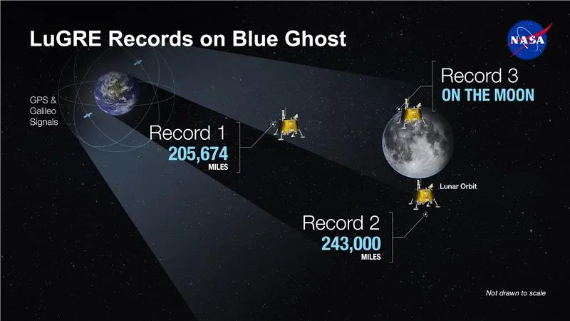
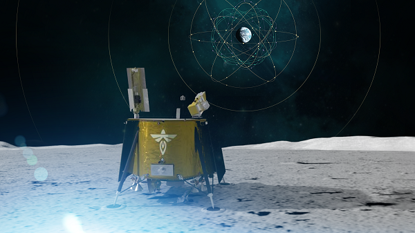
During a public workshop at the Italian Space Agency on Oct. 14-15, the Lunar GNSS Receiver Experiment (LuGRE) project team celebrated the closure of the project and released the data collected to the scientific community.
LuGRE, developed in partnership by NASA and the Italian Space Agency (ASI), flew to the Moon a GNSS receiver manufactured by the Italian company Qascom. The receiver was hosted aboard the Firefly BGM1 mission.
LuGRE demonstrated that signals from GNSS satellite constellations can also be used for positioning, navigation and timing (PNT) on the Moon.
The Navigation Signal Analysis and Simulation of the Dept. of Electroncis and Telecommunications of Polytechnic University of Turin processed the data received during the mission and contributed to all the science team activities, including the validation of the data and the processing of the initial set of scientific results.
An artist’s concept of the LuGRE payload on Blue Ghost and its three main records in transit to the Moon, in lunar orbit and on the Moon’s surface. (Image: NASA/Dave Ryan)
Launched on Firefly Aerospace’s Blue Ghost lander in January, LuGRE became the first payload to use Earth’s GNSS to calculate a navigation fix on the lunar surface and in lunar orbit. The experiment set a series of distance records on its journey to the Moon, demonstrating that GNSS technology can complement other navigation tools as far as 247,520 miles (398,350 km) from Earth.
These results point to a future where lunar astronauts, rovers and spacecraft can rely on the same satellite-based navigation systems we use every day to augment their navigation capabilities.
“It is a very important milestone for the satellite navigation community,” said Fabio Dovis, Politecnico di Torino, Italian Space Agency, of the project. “For the first time we have the recording of signal of the GPS and Galileo constellation collected in space and on the Moon surface. Already during the LuGRE mission we proved the feasibility of using satellite systems originally designed to be used on Earth up to lunar distances. Now the entire scientific community can use them to ‘re-play’ the space environment as well as analyze them in depth, for example, to retrieve information about the Earth atmosphere crossed by the signal themselves.”
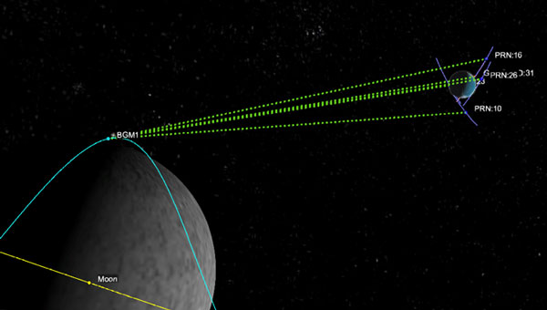
Artistic rendering of LuGRE and the GNSS constellations. In reality, the Earth-based GNSS constellations take up less than 10 degrees in the sky, as seen from the Moon. (Image: NASA/Dave Ryan)
The data release includes the actual GPS and Galileo radio signals LuGRE captured during its journey and on the lunar surface. The raw recordings — called in-phase and quadrature (I/Q) samples — allow researchers to analyze GNSS signal strength, noise and interference under lunar conditions for the first time. Engineers and scientists will use these results to model and refine the next generation of GNSS-based signal receivers and improve our understanding of how navigation signals operate at the Moon.
Graphic representation of the relative geometry of Earth-Moon-acquired GNSS satellites. (Image: Agenzia Sapaziale Italiana)
Iridium Communications is working with T-Mobile to on a broad network deployment of positioning, navigation and timing (PNT) services, starting with live-site activations across the United States. The deployments will deliver 5G network complementary timing synchronization to strengthen the cellular network’s resilience and help ensure reliability for customers.
The U.S. Department of Transportation CPNT Action Plan is designed to evaluate mature and commercially available CPNT technologies to strengthen PNT resilience and enhance the safety of critical infrastructure, like 5G networks. DOT is the U.S. government’s civil lead for PNT.
Under the contract, T-Mobile will expand its installation of Iridium PNT receivers to 90 additional live 5G network sites in geographically diverse locations. Iridium PNT will help protect against GPS disruptions that cause downtime and compromise the data integrity and performance of 5G networks, which rely on coordinated, precise timing to deliver the necessary speed, capacity and reliability of service to end-users.
T-Mobile will also perform nominal and adverse user equipment exercises at its indoor testing range. It has the necessary wireless infrastructure for DOT, Iridium, and T-Mobile to observe and record results.
Capable of sub-100-nanosecond accuracy — better than a millionth of a second — and secured using cryptographic techniques, Iridium PNT signals are 1,000 times stronger than GNSS systems like GPS and work inside buildings with no need for an outdoor antenna. The service is delivered by Iridium’s low-Earth orbit (LEO) satellite constellation, which provides global weather-resilient L-band connectivity.
Sateliot, a leading satellite telecommunications operator in 5G IoT connectivity, will test a pioneering system that allows its satellites to connect with IoT devices without relying on GNSS. The breakthrough opens new opportunities in sectors such as defense and security, where Europe’s technological autonomy and operation in GNSS-denied environments are strategic priorities.
Low-Earth orbit (LEO) satellite constellations, such as the one developed by Sateliot, provide coverage in areas beyond the reach of terrestrial networks — over half of the planet’s surface. However, until now, they depended on GNSS, increasing both the energy consumption of devices and terminal costs.
The FreeGNSSNetwork project, signed with the European Space Agency (ESA) and led jointly with GMV, eliminates this dependency using advanced algorithms that enable devices to calculate their position directly from the satellites’ signals. This maintains a stable and accurate connection even under complex conditions such as wartime scenarios.
According to the company, this project represents a paradigm shift and lays the groundwork for developing 6G technology, in which Sateliot actively contributes within the 3GPP framework.
The FreeGNSSNetwork enables device positioning with an accuracy of approximately 10 meters and provides extremely precise time synchronization services of 50 nanoseconds, the equivalent of 0.00000005 seconds.
The system is being tested in laboratories that replicate real satellite communication conditions and will be demonstrated in orbit with prototype satellites and terminals, sending positioning, navigation, and timing (PNT) data directly to IoT devices.
Real-time situational awareness (RSTA) is crucial in numerous fields, particularly in public safety, transportation and emergency management. It enables decision-makers and first responders to quickly assess situations, select appropriate actions and implement plans effectively, ensuring timely assistance and resource allocation.
RTSA is a process of continuously monitoring and analyzing information to understand what is happening in a given environment. Virtually every owner or operator has a need for this, although the data that may be relevant varies.
RTSA refers to the ability to understand your environment and act appropriately. This will enable response to events as they unfold, using integrated data from various sources to enhance decision-making and operational efficiency. [1]
While real-time situational awareness is desired by various entities, it should be noted that it does not come from a single data point, as a single data point is not sufficient. There need to be locational, temporal and informational elements present to draw reasonable conclusions. One promising tool enabling this improved decision-making is the geographic information system.
Real-Time Geographic Information System
GIS is a technology that connects data to a map, integrating location and descriptive information. GIS helps users understand patterns, relationships and locational context, and supports decision-making in various industries.
A real-time GIS can create situational awareness because of its ability to simultaneously ingest, integrate, analyze and display streaming data from most any sensor, device and social media. GIS and location-based analytics can automatically refine and focus real-time data to accomplish the mission with up-to-the-minute intelligence on what’s happening in the field and across agencies and governmental jurisdictions. That’s why police, fire and emergency management organizations at all levels of government use real-time GIS capabilities in their operations and dispatching centers.
Building Robust New Layers is Key
As the duration — or reach and impact — of an emergency event increases, so does the number of agencies involved in responding to and mitigating that event. This requires communication systems to scale accordingly, ensuring seamless information exchange and communication among those agencies.
A significant obstacle to this essential communication is the lack of interoperability, with data interoperability playing a critical role. Data interoperability is the ability of different systems, devices or organizations to share digital information so they can communicate and work together effectively. Without this interoperability, organizations face delays in decision-making, reduced response efficiencies and challenges in coordinating incident management.
The Cybersecurity and Infrastructure Security Agency published the Information Sharing Framework as an approach to address the data interoperability challenge. It puts forward a three-layer framework that presumes:
a data layer, which resides with an individual agency in its nonsharable silo;
a presentation layer, which is the end user who needs to see the data in context for real-time situational awareness and decision-making;
and sandwiched in between is an integration layer, which does the necessary translation between the data and presentation layers in which the data is discovered, accessed, exchanged, analyzed and transported to the end user. [2]
For RTSA, the system must be able to access the relevant information in the data layer, to transform and standardize that data such that it can be augmented with other data to create actionable information that can be pushed or pulled into the presentation layer to inform the end user. This information will answer myriad questions about the situation such as when, where, who and what.
Radio Frequency Real-Time Situational Awareness
In today’s world of autonomous vehicles and swarms of drones, the electromagnetic spectrum is becoming a critical part of situational awareness. Both in knowing what spectrum is available for use and what spectrum needs to be defended or excluded due to willful interference.
Even in the context of space, RF spectrum data can help monitor satellite communications and detect anomalies, providing a more comprehensive understanding of the space environment and its potential threats.
The RF spectrum frequencies range from 3 kilohertz to 3 THz (which spans 3 KHz up to 3 billion KHz). Radio waves, part of the RF spectrum, are regulated by national laws and coordinated by the International Telecommunication Union to prevent interference between different users.
Radio frequency real-time situational awareness involves the use of radio frequency data and sensors to monitor, analyze and understand this environment. It is crucial for operational planning where the electromagnetic spectrum is a critical domain.
Its ability to provide real-time awareness of radio frequencies is critical to building an actionable picture of what are very dynamic environments. For example, recognizing the critical nature of an incident as it escalates from a local situation to a regional one.
Under the Hood
Effective spectrum monitoring devices rely upon modern developments in software-defined radio (SDR) technology that facilitate rapid reconfiguration and adaptation for various tasks. These include significant enhancements not only to computing capabilities but to the neural processing unit capacity as well. In part, to facilitate RF bandwidth pattern of life technical capability including time frame to gain specific insights.
Various capabilities are also expected to emerge in the coming years associated with situational awareness that may have a significant impact on the effectiveness, safety and health of especially the first responder community. The internet of things, cameras, data from other applications and networks, and sensors continue to produce increasing amounts of data. Artificial intelligence and data analytics are envisioned to be increasingly important mechanisms to assist in enabling timely and more informed decisions.
Multipurpose Remote Sensors
RF devices used for assured positioning, navigation and timing(A-PNT) most naturally are able to provide RF mapping for situational awareness. The same RF spectrum mapping that gives operators the tools to see real and potential frequency interference and usage. Just as GIS helps provide real-time situational awareness in the physical world, spectrum mapping provides RF real-time situational awareness in the virtual world. Different data, different tools, but the same need and general approach.
Such multipurpose devices could further contribute to helping build RF situational awareness to include information about emitter identification and locations core to RF mapping. Or RF-based sensors could be able to use signals such as those used by tactical radios, once their location is established.
This fulfills the vision that these RF devices, for example, could be positioned to support RF multiple aspects of situational awareness when not performing their primary mission.
This requires RF real-time situational awareness to be integrated into operational frameworks to allow for better decision-making, improved safety and enhanced capabilities in both military and civilian applications. By leveraging RF data in multiple ways, organizations can fill gaps in traditional monitoring techniques, leading to a more robust understanding of the operational landscape. RF real-time situational awareness is a critical capability that enhances operational effectiveness using advanced sensing technologies and data analysis, particularly in complex environments.
Poised for a New Generation
A key element for the aforementioned presentation layer is to provide the same data to many, although specific locations, referred to as narrowcasting (think narrow multicasting). A new company, EdgeBeam Wireless, is building a next generation broadcast system to provide these services largely referred to as datacasting. Powered by the broadcast industry’s latest ATSC 3.0 standard, this new service will make its datacasting compatible with standard IP networks, fiber networks and mobile 3GPP networks. It could be used for very efficient geolocation delivery of all real-time situational awareness data to many specific locations. [3]
A good example of an RF-based terrestrial platform is MerlinTPS. This terrestrial positioning system provides 100% terrestrial, RF-based assured positioning, navigation and timing. As part of its operation, the system naturally makes a spectrum map within the radius of each of its reference units. For example, coverage of the entire U.S. would take about 200 reference units, plus about 100 backup units. This RF spectral map is updated with one-second iterations, keeping the data up to date for any unfolding spectral and terrestrial events.
The MerlinTPS platform is based on modern-day SDR technology, ideal for flexibility of RF spectrum presence, as well as the growing use of AI. This feature then naturally could be used to create and maintain a total spectrum map and pattern of life.
The platform supports high-precision time transfer of plus or minus 10 ns, critical to A-PNT today, along with positioning and navigation services. The platform can also provide geolocation data for modern real-time GIS features needed for this new generation of real-time situational awareness.
The combination of MerlinTPS with use of the ATSC 3.0 pending EdgeBeam Wireless service could provide the highly full-featured capabilities to fuel the newest generation of real-time situational awareness networks.
Vatn Systems has released INStinct, an inertial navigation system (INS) designed to provide GPS-free navigation for maritime operations.
The defense technology company, which manufactures autonomous underwater vehicles (AUVs) for the U.S. military and commercial clients, said the system uses technology from ANELLO Photonics to deliver navigation capabilities in GPS-denied environments at lower cost than existing systems.
The system features a modular design that allows users to configure it based on mission requirements. It can be equipped with various inertial measurement units, including ANELLO’s X3 IMU, which uses Silicon Photonics Optical Gyroscope technology. The X3 IMU is designed to withstand shock and vibration in maritime conditions.
“Inertial navigation is the cornerstone of autonomy at sea,” said Nelson Mills, CEO and co-founder of Vatn Systems. “With INStinct, we’ve created a navigation solution that meets the needs of both our own vehicles and third-party platforms, offering reliability, accuracy, and adaptability. ANELLO’s IMU technology allows us to offer an INS with FOG performance at a fraction of the traditional cost. The launch of INStinct marks another milestone in our broader strategy to own the full tech stack for underwater vehicles.”
“The integration of our technology and our ANELLO X3 IMU into Vatn’s platforms and INS marks a pivotal advancement in our mission to transform autonomous underwater navigation,” said Dr. Mario Paniccia, CEO and co-founder of ANELLO Photonics.”Our technology has been rigorously field-tested across land, air, and sea environments, and we are thrilled to collaborate with Vatn to offer an underwater navigation solution. This partnership highlights our commitment to delivering next-generation navigation solutions that empower accurate and more efficient underwater operations.”
The system supports integration with Doppler velocity logs and includes maritime-specific algorithms. Housing configurations range from original equipment manufacturer specifications to depth-rated enclosures.
Vatn Systems said it plans to deliver vehicles equipped with INStinct to customers by the end of 2025.
NextNav Inc. has successfully advanced its NextGen PNT solution commercialization path operating on standard 5G network equipment. The development represents a major milestone toward a widescale commercial 5G-powered 3D PNT solution. The company is showcasing its solution this week at Mobile World Congress in Las Vegas, booth #96.
“This latest achievement highlights the seamless integration of NextNav’s technology and 5G, reinforcing the scalability and practicality of a resilient terrestrial complement to GPS,” said Sidd Chenumolu, chief business development officer. “We have proven the technology with standard 5G equipment and look forward to the opportunity to completing the final steps to commercialization.”
NextNav completed demonstrations using Lekha Wireless Solutions 5G base stations with positioning reference signals (PRS) enabled. The partnership with Lekha Wireless Solutions, a commercial 5G infrastructure equipment supplier, brings PNT capabilities in the NextNav spectrum band.
The demonstration delivered accurate timing and positioning information via PRS transmissions while simultaneously delivering both downlink and uplink data transmissions. These capabilities align tightly with NextNav’s broader solution of utilizing standards-based 5G PRS in lower 900 MHz band spectrum for terrestrial PNT and combining it with barometric pressure sensors for vertical accuracy.
“Demonstrating these capabilities on commercial 5G equipment is a critical step towards integrating this solution into networks, a hallmark of NextNav’s 3D PNT architecture,” said NextNav Co-Founder and CTO Arun Raghupathy. “It shows that our PNT solution can be deployed efficiently using existing 5G equipment, delivering accurate timing and positioning information along with simultaneous 5G data.”
At MWC Las Vegas, NextNav will showcase these developments as well as an interactive demonstration of the company’s Pinnacle technology, highlighting how vertical location transforms government, public safety, and commercial applications.
The UK Royal Navy‘s Disruptive Capabilities and Technologies Office (DCTO) recently teamed up with scientists from the University of Sussex to test new navigation sensors developed to reduce reliance on GPS navigation.
The ultra-sensitive quantum sensors measure tiny variations in the Earth’s magnetic field, offering a new way to pinpoint locations when satellite signals are jammed or unavailable.
“We are excited and pleased to have supported this first sea trial with the University of Sussex and its quantum magnetometer technology,” said Commander Matt Steele, from DCTO. “We are also grateful to our colleagues in the Hydrographic Exploitation Group for providing one of its vessels and crew to provide a test platform.
“To ensure it can resiliently operate in GNSS-denied and degraded environments, the Royal Navy continues to explore and accelerate the development of alternative means of navigation, such as this magnetic sensor, while positioning itself as a pioneer ‘quantum-enhanced navy’.”
“GPS or GNSS signals are highly vulnerable to disruption: they can be jammed or spoofed, and they fail entirely underground, underwater, or in heavily obstructed environments,” said Tom Coussens, Research Fellow in Quantum Science and Technology at the University of Sussex. “This vulnerability has serious economic and operational consequences. While alternative systems such as inertial navigation and visual recognition exist, none simultaneously meet all critical requirements: long-term positional accuracy, weather independence, and resistance to jamming.”
In the trials, a team from the university worked with the Royal Navy’s Hydrographic Exploitation Group who survey waters, recording details of depth, seabed objects and composition. The university used its Optically Pumped Magnetometers in open waters, with the trials taking place from His Majesty’s Naval Base Portsmouth.
In addition to navigation, they also successfully mapped surrounding magnetic signatures, pointing to new methods for detecting vessels, undersea features, and potential hazards.
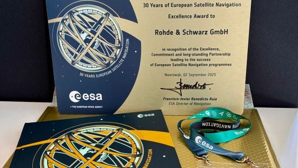
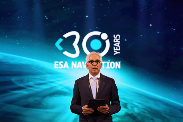
The European Space Agency (ESA) marked 30 years of European satellite navigation with a celebration Sep. 2 at its research and technology center. The event honored key contributors who have shaped the journey of systems like Galileo and EGNOS, which have positioned Europe as a global leader in satellite navigation.
Among the honorees was Rohde & Schwarz, recognized for the excellence, commitment and long-standing partnership leading to the success of European satellite navigation programs over the past three decades.
Javier Benedicto kicks off the celebration of 30 years of satellite navigation. (Photo: ESA)
The event brought together institutional and industrial partners, ESA Member State representatives, and leading figures in satellite navigation. The celebration revisited pivotal milestones in Europe’s satellite navigation history and looked ahead to future innovations.
A highlight of the evening was the award ceremony led by ESA Director of Navigation Javier Benedicto, who, alongside past directors, presented accolades to organizations and partners instrumental in this success story.
Rohde & Schwarz’s recognition underscores their role in advancing European satellite navigation technology. Their contributions have been vital in the development and operational success of Galileo and EGNOS, systems that have revolutionized positioning, navigation, and timing services across Europe and beyond.
The event not only celebrated past achievements but also set the stage for the future of European satellite navigation, with discussions around upcoming initiatives and advancements. For Rohde & Schwarz and other honourees, the evening served as both a celebration of past achievements and a call to continue building a connected, resilient, and sustainable future in space.
“Thirty years of satellite navigation is a testament to shared vision, determination to push technology boundaries, and intense, long-term collaboration,” said Rob Short, director of Business Development at Rohde & Schwarz. “We are honoured to have contributed to this remarkable achievement. Congratulations to everyone who made this milestone possible.”