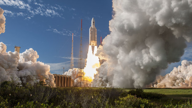
Four more Galileo satellites were launched July 25 by an Ariane 5. Their arrival in orbit brings the Galileo constellation to 26 satellites, extending the global coverage of the constellation.
Ariane 5 flight VA244, operated by Arianespace under contract to ESA, lifted off from Europe’s Spaceport in Kourou, French Guiana, at 11:25 GMT (13:25 CEST, 08:25 local time), carrying Galileo satellites 23–26. The first pair of 715 kg satellites was released almost 3 hours 36 minutes after liftoff, while the second pair separated 20 minutes later.
They were released into their target 22 922 km-altitude orbit by the dispenser atop the Ariane 5 upper stage.
In the coming days, this quartet will be steered into their final working orbits by the French space agency CNES, under contract to the Galileo operator SpaceOpal for the European Global Navigation Satellite System Agency (GSA).
There, they will begin around six months of tests by SpaceOpal to verify their operational readiness so they can join the working Galileo constellation.
“Galileo is ESA’s largest ever satellite constellation, built up to its present size in rapid time, with 22 Full Operational Capability satellites added within just the last four years,” remarked Jan Wörner, ESA’s director general.
“We must thank our industrial partners OHB (DE) and SSTL (GB) for the satellites, as well as Thales Alenia Space (FR/IT) and Airbus Defence and Space (GB/FR) for the ground segment and all their subcontractors throughout Europe for their continued support to the programme. Together with ESA, the entire industrial team has worked hard for the point at which we now are and this cooperation have proven to be very successful, as we can show in the excellent performance of Galileo.”
Paul Verhoef, ESA’s director of navigation, added, “Galileo has been providing Initial Services on a worldwide basis since 15 December 2016, and today has more than 100 million users, and rapidly increasing. Today’s satellites will increase the global coverage of Galileo with a performance that is widely recognized as excellent.
“This is the end of the current phase of Galileo deployment, but our pace is not slacking. A further 12 Galileo ‘Batch 3’ satellites are in preparation as in-orbit spares and as replacements for the oldest Galileo satellites, first launched in 2011, in order to keep the system working seamlessly into the future.
The European Space Agency launched the next four Galileo satellites on an Ariane 5 on Wednesday July 25, at 11:25 GMT (13:25 CEST, 08:25 local time) from Europe’s Spaceport in Kourou, French Guiana.
These latest four Galileo satellites will bring the constellation in orbit up to 26 satellites.
Livestream coverage of the launch starts at 11:00 GMT (13:00 CEST) with liftoff at 11:25 GMT (13:25 CEST).
Live coverage resumes with confirmation of the satellites separating from their upper stage from 14:50 GMT (16:50 CEST).
Separation of the Ariane 5’s upper stage occurs about nine minutes after liftoff, followed by the first 10-minute firing of the upper stage.
The upper stage — carrying four 715-kg Galileo satellites — flies in ballistic configuration for three hours and eight minutes, after which a second upper stage firing lasting just over six minutes will place it into circular separation orbit.
Once stabilized at 3h 36 min after liftoff, the Galileo dispenser will release the first two satellites, followed by the second pair 20 minutes later.
In the meantime, check out ESA’s new Galileo video.
The Ariane 5 carrying Galileo satellites 23-26 is in place at the ZL3 launch site ready for liftoff. (Photo: ESA)
Ligado’s proposed broadband service continues to pose a significant risk of harmful interference to GPS, several key signatories wrote in a July 18 letter to U.S. Federal Communications Commission (FCC) Chairman Ajit Pai.
The interference would occur despite Ligado’s May 31 amendments to its license modification applications, the letter states. “The proposed Ligado operations, even after the recently proposed amendments, will harmfully impact a wide range of GPS receivers and thus should not be permitted.”
Key signatories include representatives of Iridium Communications, the International Air Transport Association, Lockheed Martin, Rockwell Collins and Satelles.
The letter urges the FCC to deny Ligado’s pending license modification application unless Ligado can show it has addressed the substantive GPS interference concerns. Also encompassed in the letter are concerns over interference with satellite communications (SATCOM) and weather data.
“The record, augmented by recent government reports, makes clear that the interference will be particularly impactful to the countless government and commercial entities that rely on GPS and SATCOM services for aviation safety and other critical services,” the signatories wrote.
“A number of data points underscore the flaws in the way in which Ligado has attempted to measure interference to GPS from its proposed terrestrial operations.”
Ligado recently acknowledged that its license modification request as originally filed is insufficient to protect certified aviation GPS receivers, but offered no changes to its proposal to address interference to uncertified GPS systems, SATCOM services (also important for aviation safety), or concerns of the weather data community.
“Evaluating Ligado’s recent amendment to ensure protection of uncertified GPS receivers and protection of GPS receivers from aggregate interference will be necessary,” the letter states.
1-dB Criterion. One issue is the 1-dB degradation interference protection criterion, which Ligado has suggested is “neither accurate nor reliable.” That criterion was used in the U.S. Department of Transportation’s Adjacent Band Compatibility assessment issued in April, which examined the maximum transmitted power levels of adjacent band systems that can be tolerated by GPS receivers. The study endorsed and strictly applied the 1-dB criterion, and termed it the “accepted, worldwide standard for PNT and many other radio communication applications.”
“Each of these government efforts supports one conclusion — the proposed Ligado operations, even after the recently proposed amendments, will harmfully impact a wide range of GPS receivers and thus should not be permitted…
“We urge the Commission to deny Ligado’s pending license modification application as proposed unless Ligado can show it has addressed the substantive GPS, aviation, SATCOM, and weather data interference concerns still outstanding in the record,” the letter concludes.
The European Union (EU) project BLUEGNSS has been developing GNSS applications in selected European airports to increase safety and airport accessibility, according to the European Commission’s Community Research and Development Information Service (CORDIS).
BLUEGNSS’s focus has been on advancing the adoption of the Galileo system in Greece, Italy, Cyprus and Malta. The four countries together form the Blue Med functional airspace block (FAB): airspace in which air traffic is managed irrespective of national boundaries. Blue Med is one of the nine FABs formed in Europe to reduce the fragmentation of the European air traffic network.
Three-dimensional GNSS approaches are being designed for 11 airports in the Blue Med FAB: four each in Greece and Italy, two in Cyprus and one in Malta.
The primary aim is to harmonize the implementation of required navigation performance approaches among the four countries, CORDIS said. This will enable aircraft to fly along precise flight paths with greater accuracy, and will make it possible to pinpoint aircraft position with precision and integrity.
Three new procedures. So far, substantial progress has been made towards safety and airport accessibility in the target countries. Since the beginning of 2018, three new GNSS procedures have been validated for Italian airports Cuneo, Lamezia and Parma, followed by another two for Larnaca and Paphos in Cyprus.
The poor weather conditions under which the Cyprus GNSS approaches were validated served to demonstrate the benefits of GNSS vertical guidance. Since its launch in 2016, BLUEGNSS has designed and validated 14 GNSS procedures.
Augmented performance of Galileo has been achieved through the European Geostationary Navigation Overlay Service (EGNOS). EGNOS is a satellite-based augmentation system that improves GNSS positioning. Its three satellites and network of more than 39 reference stations in 24 countries enable it to provide greater accuracy than Galileo alone.
EGNOS’s safety advantages and lower investment costs greatly benefit small and regional airports, which usually can’t afford the high costs of installing and maintaining ground-based navigation aids.
For this reason, BLUEGNSS has promoted its use in this geographically challenging Mediterranean region.
“The southeast Mediterranean region lacks full EGNOS coverage,” said GNSS expert Patrizio Vanni of ENAV S.p.A., project coordinator and Italy’s air navigation service provider. “To make things even more challenging, each airport involved in the project presents a very different operational environment.”
The project hasn’t only focused on designing and validating GNSS approaches at airports where no such procedures have been available up to now. It has also provided the necessary training and monitoring to support implementation by the Blue Med FAB countries.
Now close to completion, BLUEGNSS (Promoting EGNSS Operational Adoption in Blue Med FAB) is the first project of its kind to be coordinated at FAB level. It may serve as a catalyst to spread required navigation performance approach know-how in the region and beyond, to the whole of Europe.
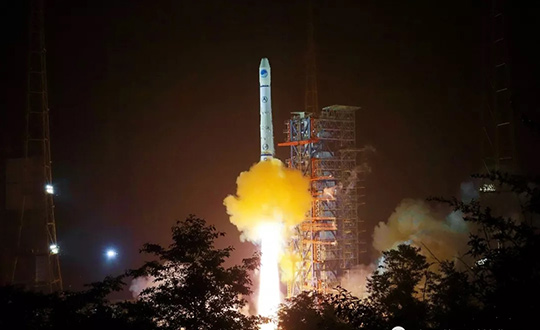
China sent a Beidou-2 backup navigation satellite into orbit on a Long March-3A rocket from the Xichang Satellite Launch Center, in the southwestern Sichuan Province, at 4:58 a.m. on July 10, according to Xinhua.net.
China started to construct the third-generation of Beidou system in 2017, and eight Beidou-3 satellites are now in space. The satellite just launched is a second-generation Beidou-2, and the 32nd of the Beidou navigation system.
“The launch of a backup Beidou-2 satellite will ensure the system’s continuous and stable operation,” said Yang Hui, chief designer of the Beidou-2 series.
Some of the Beidou-2 satellites are nearing the end of their lives and need to be replaced by backup satellites. China launched two backup satellites on March 30 and June 12, 2016.
This new backup is not a simple repeat of previous satellites, but has been upgraded to improve its reliability, Yang said.
It carries redundant rubidium clocks, which is the key to the accuracy of its positioning and timing.
When China began reform and opening-up 40 years ago, its satellites mainly used costly imported rubidium clocks. After the launch of the Beidou program, the United States banned exports of rubidium clocks to China.
Sun Jiadong, chief designer of the Beidou system and an academician of Chinese Academy of Engineering, said China must depend on itself.
China’s first self-developed rubidium clock was tested on a satellite in September 2006. The performance of China’s rubidium clocks was improved on Beidou-2 satellites.
This year will see an intensive launch of Beidou satellites. The system is expected to provide navigation and positioning services to countries along the Belt and Road by late 2018. By around 2020, the Beidou system will go global.
Photo: Xinhua.net
The Beidou-3 satellites can send signals that are compatible with other satellite navigation systems and provide satellite-based augmentation, as well as search and rescue services in accordance with international standards. The positioning accuracy is 2.5 to 5 meters.
The Beidou system will coordinate with other technology, such as remote sensing, the Internet, big data and cloud computing, in future.
In the past five years, the system has helped rescue more than 10,000 fishermen. More than 40,000 fishing vessels and around 4.8 million commercial vehicles in China have been equipped with Beidou, said Beidou spokesperson Ran Chengqi.
China has sold more than 50 million domestically manufactured chips connected to the Beidou navigation and positioning system in the past five years.
By 2020, the value of China’s satellite navigation business is expected to surpass 400 billion yuan (about 58 billion U.S. dollars), of which 240 billion to 320 billion yuan will go to the Beidou system, Ran said.
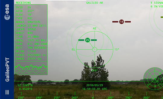
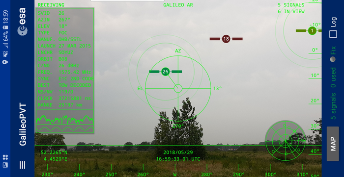
The European Space Agency (ESA) has released an augmented reality view of Galileo satellites in the sky close to its technical centre in the Netherlands.
The image comes from a Galileo-focused satnav app for Android smartphones, developed by ESA engineers. ESA ran an internal competition for its trainees to develop an app capable of making positioning fixes using only Galileo satellites.
“As part of our support for the competition, we developed our own app on a voluntary basis to serve as a benchmark,” said Paolo Crosta of ESA’s Radio Navigation Systems and Technology section. “We included this augmented reality view, so users can ‘see’ the satellites their smartphone is using as they hold it up to the sky.”
Galileo satellites viewed in smartphone app. (Photos: ESA)
The positioning calculations and assistance data functions for the app were developed by Paolo, with telecom engineer Tim Watterton contributing the main structure of the app, together with how it looks and its user interface.
“The satellites are overlaid in real time on the camera view in their predicted positions in the sky, based on ‘ephemeris’ information, assistance data that describes the current satellite orbits with high precision,” Watterton said. “When a signal is being received, the satellite is shown in green, overlaying the predicted position. The satellite shown in red is one of the two placed in elongated orbits, but these satellites are expected to be used soon in the operational constellation. Satellites colored orange are transmitting, but the signal is not detected, which may be due to obstruction by terrain or buildings.”
Panning the phone around to position the crosshair over a green-colored satellite adds additional information, such as its signal status, pseudorange (the uncorrected distance the signal has traveled to reach the receiver) plus the satellite’s manufacturer and launch date, among other items.
The reference app is now being tested with the hope of making it publicly available on the Google Play Store. Following the competition, the trainees are also testing their own apps with the goal of releasing them.
Charles Curry, founder of Chronos Technology, with the RIN award. (Photo: Chronos)
Chronos Technology has been recognized by the Royal Institute of Navigation (RIN) with its 2018 Duke of Edinburgh’s Navigation Award for Outstanding Technical Achievement in “recognition of technical excellence and authority in satellite navigation and timing vulnerabilities and mitigations.”
Charles Curry, founder and managing director of Chronos Technology, accepted the award at the RIN Annual General Meeting held June 10 in London.
Chronos has worked with the RIN and others since 2008 to raise awareness of GNSS vulnerabilities, and in collaboration with the University of Bath has developed a family of GNSS interference detection products.
Chronos first started researching this phenomenon with the University of Bath in the Innovate U.K. project GAARDIAN in 2008, closely followed by the SENTINEL and AJR projects. The projects have focused on detecting and locating commercial off-the-shelf jammers mostly sourced from Chinese websites.
The first success was seizing the so called “Girvan Jammer” in 2011, when a jammer was recovered from a commercial van driver through collaboration with the serious and organized crime group of the local police.
This exercise took about two weeks from initial detection to recovery of the jammer and should be compared to the six months it took U.S. enforcement agencies to identify the so called “Newark Jammer.”
SENTINEL sensors were originally rolled out in 2010 continue to provide real evidence of jamming at various locations around the U.K. The project assists police work by collating jamming events by day and time of day using a cloud-based portal.
The GPS interference detection portfolio includes low-cost, handheld GNSS interference detectors with features such as data logging and direction finding capabilities to precisely pinpoint a jammer.
The latest product to emerge is known as “JammerCam,” and is the first GPS jamming detector in the world to be able to take photographs of a moving vehicle, which is carrying a GPS jammer. This is now in trials with various local police forces and is photographing vehicles with jammers on a daily basis, providing real-time actionable intelligence to the law enforcement officers’ smartphones identifying vehicle type, color and number plate.
Early trials with this research are leading to the seizing of at least one jammer per week by U.K. law enforcement agencies.
Chronos has demonstrated the ability to work with universities and potential users to develop new, affordable products to meet a genuine need. Customers include U.K. and international law enforcement agencies and military users.
“This is a very prestigious award, as a look at the previous winners will attest,” said John Pottle, director of the Royal Institute of Navigation. “Chronos is very well respected and has continued to innovate, achieving global influence from their U.K. base. Many congratulations to all at Chronos for this well-deserved recognition.”
Curry was awarded Fellowship of the Royal Institute of Navigation in 2016 in recognition of his significant and continuing contribution to the practical aspects of time measurement and dissemination, including research into GNSS vulnerabilities and the use of eLoran for precise time.
“Chronos is honored to be the recipient of the RIN’s 2018 Duke of Edinburgh’s Navigation Award for Outstanding Technical Achievement,” Curry said. “We could not have done this without our close association with the University of Bath, in particular Dr. Robert Watson and Professor Cathryn Mitchell and their colleagues in the Electrical & Electronic Faculty.
Over the years, this association has enabled Chronos to undertake research and bring to the market GPS jamming detection products which have been thoroughly field tested at locations such as Sennybridge in the Brecon Beacons, and other international jamming trials in Norway and the U.S.
“In particular, Chronos was the only British company to be invited to JamX17 in Idaho Falls, U.S., by the U.S. Department of Homeland Security to showcase the detectors’ technology,” Curry said.
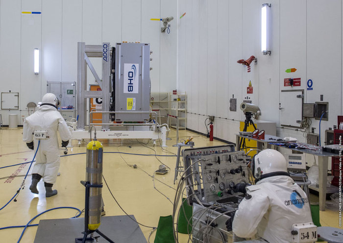
Technicians in SCAPE (Self Contained Atmospheric Protection Ensemble) suits fill Galileo satellites 22-26 with hydrazine fuel. (Photo: ESA)
Europe’s next four Galileo satellites have been fueled at Europe’s Spaceport in Kourou, French Guiana, in preparation for their launch on July 25, according to the European Space Agency (ESA).
The four satellites were placed into their protective containers to be transported from the S1A processing building to the S3B payload preparation building, where they were filled with the hydrazine fuel that will keep the satellites manoeuverable during their 12-year working lives.
The next step is to fit the quartet onto the dispenser that holds them in place securely during launch and then releases them into space once the upper stage of the Ariane 5 rocket reaches its 22,922-kilometer-altitude target orbit.
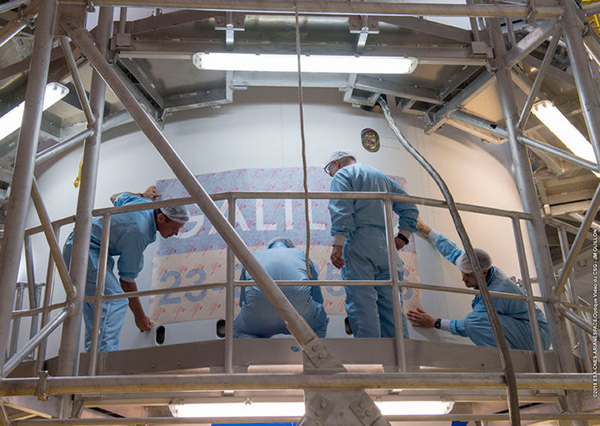
After that, the satellites plus dispenser will be fitted onto the upper stage then enclosed by the two sides of the protective launch fairing — one of which has had the mission logo added to it.
Meanwhile, the Ariane 5 for this launch (Flight VA244) has undergone assembly inside the Spaceport’s Launcher Integration Building.
Galileo’s Flight VA244 mission logo is attached to the Ariane 5 fairing ahead of the July 25 four-satellite launch. (Photo: ESA)
Did you know Australia doesn’t exist? (Sorry, Aussies.) The entire continent is part of a massive conspiracy designed to confuse you. Anyone who says they’re from Australia is an actor (paid by NASA, probably.) And all the airline pilots are “in on it,” flying people to a carved out section of South America.
The “rationale” (I use the word very lightly) seems to be that Britain just wanted to dump its convicts in the ocean, so made up the continent to tell people where they were taking them.
These and other “theories” spouted by Flat Earthers are akin to falling down a rabbit hole where up is down and round is flat. How can they believe such nonsense?
The 1893 Orlando Ferguson map imagines Antarctica as a wall of ice around the world. (Image: Library of Congress/2011594831)
Last year, the flat Earth idea became national news when rapper B.o.B. used Twitter to jump on the flat Earth bandwagon, even starting a GoFundMe campaign to find Earth’s curve. B.o.B.’s campaign wants to “launch multiple weather balloons and satellites into space” to observe (and try to disprove) what centuries of science and technology have already confirmed. So far, he’s raised less than $7,000 of his $1 million target.
How do Flat Earthers explain GPS? Is there a way to convince them that they’re wrong? Probably not. Anyone who tries is met with an argument that their evidence is faked or faulty. GPS satellites aren’t in space — there’s a “celestial dome” over the Earth. Or the signals are really from giant towers and the G stands for ground. Or Google has laid cables across the oceans to track you.
Astrophysicist Neil DeGrasse Tyson blames the educational system — not for teaching insufficient science subjects so much as needing to improve critical thinking skills. “Our system needs to train you not only what to know, but how to think about information, knowledge and evidence,” he said.
Should we bother to convince Flat Earthers they’re wrong? Some on the internet could be trolls toying with arguments and theories. True believers, however, are an extreme minority, and there will always be people who choose to believe in “alternative facts.” Let’s hope they remain a minority.
The Australian government is investing in GPS technology that will create jobs and support Australian industry.
Minister for Resources and Northern Australia, Senator Matt Canavan, said the government is investing more than $260 million to develop the satellite technology.
“We rely on satellite and GPS technology for just about every aspect of our lives — from Google Maps on our individual phones, through to air traffic control at the busiest airports,” Canavan said. “More precise technology will make Australian businesses more productive, safer and more efficient.
Specifically, Canavan said, “More accurate GPS will improve productivity by allowing new technology to be created and used across the economy. Growing Australia’s digital economy will also benefit developed sectors such as mining, transport, construction, aviation and agriculture. “This investment will improve competitiveness and secure jobs across the Australian economy.”
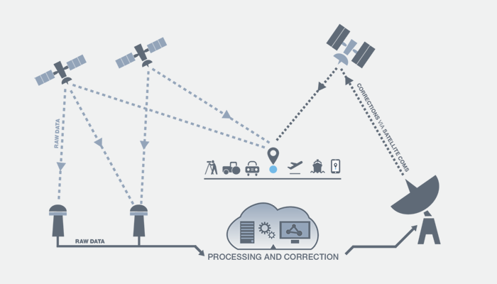
SBAS Testbed. Under the package, $160.9 million will deliver a Satellite-Based Augmentation System (SBAS) to improve the reliability and the accuracy of positioning data from five meters to 10 centimeters across Australia and its maritime zone.
The $160.9 million includes funding over four years from 2018-19 and $39.2 million in ongoing funding from 2022-23. It will realize the SBAS testbed, which is currently running across Australia-New Zealand.
CRCSI is an international research and development centre set up in 2003 under the Australian Government Business Cooperative Research Centres Programme. The CRCSI is managing the industry-based demonstrator projects of the SBAS testbed and the economic benefits study. The infrastructure management is being led by Geoscience Australia in partnership with Land Information New Zealand and the global technology companies GMV, Inmarsat and Lockheed Martin.
“We have been coordinating multiple trials of first and second generation SBAS and Precise Point Positioning correction signals since mid-2017,” said Graeme Kernich, CRCSI CEO. “Our industry partners are crying out for this technology because a more precise positioning capability brings far-reaching and lasting impacts.
“Data analysis results and the economic benefits reported from the testbed are very promising and will translate across agriculture, aviation, consumer, construction, maritime, mining, rail, road, spatial and utilities.
“This is a formidable technology story and a practical demonstration of downstream space applications. We are looking forward to continuing the testbed over the coming nine months and assessing the economic and social benefits the operational system will bring to Australia, and possibly New Zealand,” Kernich said.
“The CRCSI has a strong track record of bringing the best people together from the private sector, government and academia to solve the most complex spatial problems; the SBAS testbed is one of the finest examples of this,” Kernich said.
“More accurate and reliable satellite positioning technology will improve the safety and efficiency of many sectors across Australia and New Zealand,” he said. “There are 28 projects across 10 sectors, with over 150 collaborating organizations currently involved in the testbed, making the footprint of this world-first trial truly trans-Tasman.”
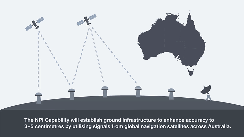
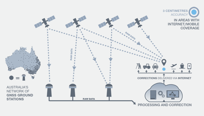
National Positioning Infrastructure. A $64 million investment in the National Positioning Infrastructure Capability (NPIC) will complement SBAS to improve GPS to an accuracy as precise as 3 centimeters in areas of Australia with access to mobile coverage.
The national positioning infrastructure project will establish additional ground stations and augment GNSS signals to deliver high accuracy positioning. This will ensure nationally consistent and accurate positioning of 3 centimeters can be provided across Australia in areas with mobile coverage. The project will achieve this by:
building new GNSS ground stations and integrating existing stations to enable multiple GNSS signals to be received for precise positioning across Australia.
establishing a GNSS data analytics capability to verify and correct the positioning signals for the user. This will ensure Australian industry has access to world-leading software tools for positioning.
engaging existing and new industries and service providers to raise awareness of the opportunities positioning opens up for businesses through increased productivity, safety and innovation.
“Our investment in this world-standard technology will have direct benefits including virtual fencing for farms and better management of cattle and livestock over vast distances,” Canavan said.
“It also has applications for regional aviation such as improved access to regional areas by enabling planes to land on smaller airstrips and navigate difficult terrain such as canyons.
“The increased reliability provided by better GPS will improve safety for aircraft flying into regional and remote aerodromes, such as the Royal Flying Doctor Service fleet. It will reduce the impact of weather on flight cancellations and diversions, and improve the safety of landings.
“The resource sector will also benefit through better control of mine infrastructure, safety and more precise data for environmental rehabilitation.
“This is a practical investment to improve the lives of Australians and make businesses more productive. This technology provides instant, reliable and accurate positioning information, anytime and anywhere around Australia.”
Digital Earth Australia. A further $36.9 million is for Digital Earth Australia, a technology that will give Australian businesses greater access to reliable, standardized satellite data that identifies physical changes to the Australian environment.
“The practical benefits of this investment will extend across our economy. This data will help researchers, governments and business better understand environmental changes, such as coastal erosion, crop growth and water quality,” Canavan said. “For example, information drawn from satellites is vital to help graziers increase the capacity of paddocks and make their farms more viable and sustainable.
“Our investment in satellite imagery will ensure a range of Australian industries have access to data that can help them tailor their investments, create jobs in target regions and increase their competitiveness.”
Europe’s satellite navigation system Galileo is already in use worldwide, usable by itself or in combination with the U.S. GPS. Now a combined Galileo–GPS positioning fix has been achieved in space — aboard the International Space Station — through an ESA–NASA collaboration.
In April, the chest-sized SCaN (seen left of center with an antenna on top) was used to make the first combined Galileo-GPS positioning fix in orbit from the ISS. (Photo: ISS)
Low-Earth orbiting satellites routinely make use of satellite navigation signals to pinpoint their position in space and allow their paths through space to be fixed with extremely high accuracy, known as “precise orbit determination.”
So far, such positioning has mainly been performed using GPS, but this new test proves it can also be achieved on a dual-constellation basis with both GPS and Galileo — as well as through the sole use of Galileo.
The experiment is based on the use of a reconfigurable NASA receiver called the Space Communications and Navigation Testbed, SCaN, attached to the exterior of the ISS.
ESA’s Navigation Support Office, based at its ESOC control centre in Darmstadt, Germany, teamed up with its Radio Navigation Systems and Technology team, located at its ESTEC technical centre in Noordwijk, the Netherlands, and Italy’s Qascom company to develop the techniques, software and firmware required for the experiment, which was passed to NASA’s Glenn Research Center in Ohio for upload to the receiver.
The International Space Station. (Photo: ESA)
“SCaN is a versatile software-defined radio receiver in space for both telecommunications and navigation testing, delivered to the Station back in 2012,” said ESA radio-navigation engineer Pietro Giordano. “It made it possible, with suitable modifications, to demonstrate combined GPS-Galileo positioning determination of the ISS.”
The algorithm developed for the SCaN Testbed had to take account of the high dynamics involved, and resulting Doppler shifting of signals: not only are the Galileo and GPS satellites moving at orbital velocity, so is the ISS itself. Orbital information of all the satellites in both constellations was included in the algorithm, allowing SCaN to make a ‘warm start’ – to search out signals in the correct segments of the sky.
In February 2006, the Navigation Support Office inaugurated its modern Navigation Facility at the European Space Operations Center (ESOC) in Darmstadt, Germany. (Photo: ESA)
In February 2006, the Navigation Support Office inaugurated its modern Navigation Facility, at the European Space Operations Center (ESOC), in Darmstadt, Germany.
“Dual constellation fixes offer many advantages for space, providing extremely robust and high-precision positioning,” Pietro added. “More signals become available overall, and the quality of the Galileo Open service and modernised GPS signals are extremely good.”
Werner Enderle, overseeing the project at the Navigation Support Office noted, “These excellent first results, coming out of great teamwork within ESA, collaboration with industry and with our NASA partners, mark just the beginning of our project data analysis. Many other exciting results are expected related to signal aspects, precise orbit determination and positioning based on optimised algorithms.”
James J. Miller, GPS Sr. Technologist within the SCaN programme office at NASA Headquarters, commented: “We’ve been promoting interoperability of GPS and Galileo through a number of activities within the United Nation’s International Committee on Global Navigation Satellite Systems (GNSS). In particular, NASA, with ESA and other national space agencies, has been identifying benefits to be gained for high altitude users in the multi-GNSS Space Service Volume under development. By further demonstrating multi-GNSS capabilities in low Earth orbit, the drive for additional utility at geostationary orbit and beyond is only strengthened.”
Europe’s Galileo system began Initial Services for users in December 2016, and there are 22 Galileo satellites in orbit. The launch of four more Galileo satellites by Ariane 5 is scheduled for July 25, and will bring the constellation to 24 satellites plus two orbital spares.
ESA is developing dual Galileo-GPS receivers for the next generation of Earth-observing Sentinel satellites. The more precise the orbit determination, the more accurate the environmental data that can be returned to Earth.
Combined use of Galileo and GPS signals on an interoperable basis for positioning and precise orbit determination should bring significant advantages for space users in particular, set to provide a seamless navigation capability from low to high Earth orbits — and potentially beyond.
“This shows the versatility of the Galileo system and the use of the system for scientific and other purposes, way beyond traditional navigation services,” said Paul Verhoef, ESA’s Director of Navigation. “We have also started work to determine whether we can use Galileo, in combination with GPS and other systems, for navigation to the Moon.”
Ceva has launched the successor to its Ceva-Dragonfly NB1 solution targeting the NB-internet of things (IoT) market, the Ceva-Dragonfly NB2.
The Dragonfly NB2 is a highly integrated and modular solution optimized for Cat-NB2 (3GPP Release 14 eNB-IoT) that can seamlessly be incorporated into chips and modules by the multitude of companies looking to address the large and fast-growing cellular IoT space.
GNSS hardware package. For customers developing NB-IoT products that also require GNSS capabilities, Ceva-Dragonfly NB2 includes a new power-optimized GNSS hardware package, with GNSS RF receiver and multi-constellation digital front-end.
The GNSS package speeds up both acquisition and tracking tasks by up to 8 times compared to Ceva-Dragonfly NB1, enabling a host of popular NB-IoT use cases, including people, livestock and asset tracking, and geo-fencing, the company said.
IoT boom forecast. In the latest edition of the Ericsson Mobility Report, the forecast for cellular IoT increased significantly, almost doubling to 3.5 billion connections for 2023. The report cites large-scale deployments in China and increasing interest in eNB-IoT and Cat-M1 cellular IoT standards as the catalysts for 30 percent CAGR between 2017 and 2023.
Ceva-Dragonfly NB2 is a licensable Rel14 compliant eNB-IoT solution and builds on the success of Ceva-Dragonfly NB1, which has been widely licensed for a range of use cases and emerging end markets, including smart cities, transport and logistics and consumer electronics. It is centered on the Ceva-X1 DSP/control processor featuring an enhanced Instruction Set Architecture and provides a unified processor environment for both physical layer and protocol stack workloads.
The solution also includes a highly integrated, worldwide enabled RF transceiver, a power amplifier (PA) and all the associated hardware and software modules required to develop a complete eNB-IoT product, ensuring the lowest possible bill-of-materials (BOM) in the process.
In addition to the performance improvements enabled by Release 14 including higher data rates and lower latency, Ceva-Dragonfly NB2 features a range of enhancements to ensure higher performance, added functionality and increased security for NB-IoT applications compared to its predecessor.
A new power management solution, complete with intelligent sleep mechanisms ensures ultra-low sleep power consumption of a few microAmps, further improving the battery life critical to every NB-IoT device.
The enhanced RF design is already silicon-proven at 55nm and 40nm processes, further lowering the entry barriers for customers with no previous cellular expertise to enter this burgeoning market.
Ceva-Dragonfly NB2 also includes the fully optimized physical layer and protocol stack firmware designed for Release 14 Cat-NB2. The addition of an on-chip embedded flash memory and controller now allows full NB-IoT design on a single die which further reduces BOM and power consumption.
Voice trigger. Ceva-Dragonfly NB2 also supports use cases requiring always-listening voice trigger, voice commands and sound sensing. The flexibility of the Ceva-X1 IoT processor allows for these sensing features to be implemented in software. The Ceva ClearVox voice front-end software package, for example, can be used to ensure clear and intelligible voice pickup for use cases such as emergency calls and voice panic buttons. In terms of security, Ceva-Dragonfly NB2 integrates a completely redesigned secure platform, including smart interfaces to connect USIM or eSIM. Ceva also offers other complementary technologies addressing massive IoT, such as Bluetooth 5 dual-mode and low energy and Wi-Fi 802.11n/ac/ax, for short range connectivity which customers can leverage for their product designs.
“The widespread commercial deployment of NB-IoT is well underway across the globe and we’re proud to be at the forefront of technology innovation for long-range massive IoT,” said Michael Boukaya, vice president and general manager of the wireless business unit at Ceva. “With the introduction of Ceva-Dragonfly NB2, we have built on the considerable success we achieved with our first generation solution, and delivered a unique, silicon-proven eNB-IoT Release 14 solution for our customers that is unprecedented in terms of system completeness, performance and power efficiency.
“Moreover, the option of power-optimized GNSS, voice and sensing capabilities vastly increases the breadth of use cases our customers can address with this licensable solution,” Boukaya said. “There is no other IP company in the world today that can come close to offering such a complete solution for eNB-IoT and we’re excited to closely partner with our customers to create a whole new wave of applications and devices for the infinite Internet of Things.”
Ceva-Dragonfly NB2 is available for licensing now. Development kits and reference silicon will be available in the third quarter of this year.