The Trimble Catalyst software-defined GNSS receiver for Android phones and tablets has been updated to support GLONASS. The update demonstrates the advantages of software GNSS for delivering new functionality faster and easier, according to Trimble.
Access to the GLONASS constellation increases the number of GNSS satellites visible when working in the field. As a result, it improves the ability to maintain lock on enough satellites to keep working when sky visibility is limited or obstructed, such as under tree canopy and in urban high-rise environments, Trimble said. Users also spend less time waiting for the receiver to achieve an accurate position, and convergence time is faster and more reliable.
Trimble Catalyst provides users with positioning-as-a-service to collect highly accurate location data with Trimble or third-party apps on Android smartphones and tablets. When combined with a small, lightweight, plug-and-play DA1 digital antenna and Catalyst subscription, the receiver provides on-demand GNSS positioning capabilities, and transforms consumer devices into centimeter-accurate mobile data collection systems.
“Adding GLONASS to Trimble Catalyst provides productivity improvements and more robust positioning for Catalyst users,” said Gareth Gibson, Catalyst business development manager at Trimble. “In addition, since the service is provided via an Android app, performance updates are available through the Google Play store. As a user, receiving updates is easy and automatic.”
The Federal Aviation Administration’s Geosynchronous Earth Orbiting 5 Wide Area Augmentation System (WAAS) navigation payload, developed by Raytheon’s Intelligence, Information and Services business, is now operational and fully integrated into the WAAS network.
The GEO 5 payload joins two others already on orbit in correcting GPS satellite signal ionospheric disturbances, timing issues and minor orbit adjustments, giving users increased coverage, improved accuracy and better reliability, Raytheon said.
“GPS alone can’t meet the FAA’s stringent requirements for accuracy, integrity and availability,” said Matt Gilligan, vice president of Raytheon’s Navigation, Weather and Services mission area. “The WAAS network corrects even the slightest errors, and that provides peace of mind when it comes to safety of flight.”
In operation since 2003, WAAS increases GPS satellite signal accuracy from 10 meters to 1 meter, ensuring GPS signals meet rigorous air navigation performance and safety requirements for all classes of aircraft in all phases of flight, Raytheon added.
WAAS provides precision navigation service to users across the United States from Maine to Alaska, as well as portions of Canada and Mexico.
For aviation users, WAAS offers pilots more direct flight paths, precision airport approaches and access to remote landing sites without depending on local ground-based landing systems.
Raytheon is the system integrator on the GEO 5 system, which includes a WAAS navigation payload on Eutelsat’s GEO satellite, two ComSAT ground sites and SED Systems specialized equipment.
As the dust from this year’s AUVSI Xponential show, which took place May 1-4 in Denver, begins to settle, we complete the overview we began last month and wrap up our coverage of the show.
Septentrio
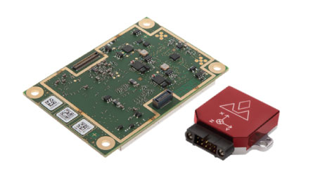
Septentrio introduced its AsteRx-i V product series of integrated GNSS/inertial receivers, based on the Septentrio m2 GPS/GLONASS/Galileo/BeiDou/QZSS/SBAS receiver and a high-end VectorNav MEMS IMU. Providing:
AsteRx-i V receiver & IMU. (Photo: Septentrio)
Reliable, accurate IMU-enhanced GNSS positioning down to the cm level
Full attitude — heading pitch and roll
Lightweight, low power <50 grams, typically 1.5 W — suitable for UAV applications
AIM+ interference monitoring and mitigation system
High update rate, low-latency positioning and attitude
Also introduced at the show was the AsteRx SB, a packaged version of the m2 receiver with multiple interfaces and Bluetooth wireless, targeted at machine control and other sensor fusion applications.
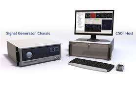
GSS9000 Simulator. (Image: Spirent)
Spirent Federal
Spirent offered a demo of its “flagship” GSS9000 simulator at the show — with capability to generate all constellations, all frequencies, plus L-band signals. Kalani Needham (director of sales) also mentioned the company’s sim-MNSA program with Rockwell Collins, aimed at providing support for M-code for the GNSS simulation market.
DJI
Inspire drone. (Image: DJI)
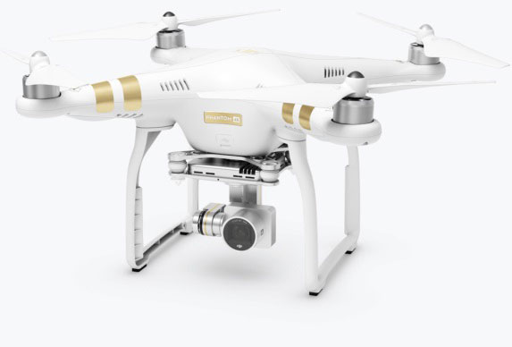
As usual, the DJI booth was extremely busy — with a demo area almost continuously flying each of the most popular DJI drones. What I learnt from my visit was that 70 percent of sales are recreational, and the balance is commercial. With quadcopters for hobbyists, using replaceable parts, auto-flight systems and data links, DJI was virtually the first drone manufacturer to market, and still one of the most successful. The Phantom now carries gimbal-mounted cameras and is finding lots of applications with business, academics and government agencies, including first adopters like the film and TV industry.
Phantom 3 drone. (Image: DJI)
DJI drones have weather resistant bodies, strong blades, swap-out easy-charge batteries, and ADS-B, RTK and heading capabilities. Set-up in the field is simple, with an SDK for lab developers, multi-spectral cameras for applications such as crop growth monitoring, real-time data available through the control uplink and infrared/visible slant-range outputs.
DJI’s approach is to keep ahead of the competition by adding more and more technology over time, and the company clearly has the sales volume to support this strategy.
CyPhy Works
PARC tethered drone system. (Photo: Tony Murfin)
CyPhy Works makes and promotes tethered drones — enabling very long endurance reconnaissance/forward observation/inspection/communications. The company got into this specific drone niche because it found customers who couldn’t live with short duration battery-restricted drone operations.
For ground forces, having a real-time video overview from higher altitude is of great benefit; similarly, they’re of great use for disaster recovery efforts, such as in the aftermath of hurricane Harvey in Texas. And if you add a Wi-Fi transducer working through one of two payload ports on its PARC (persistent aerial reconnaissance and communications) platform, you can also reconnect survivors and provide a comms network for first responders.
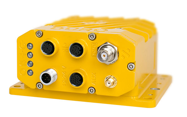
Ruggedized Duro receiver. (Image: Swift Navigation)
Swift Navigation
Swift is a relatively new GNSS receiver manufacturer, and its Piksi Multi receiver has a lot to do to catch up technically with the products offered by the predominant players in the market. So its approach is to use rock-bottom pricing for almost all of their offerings. Currently, the Piksi has only GPS L1/L2 and GLONASS L1/L2 plus SBAS, but Galileo and BeiDou are promised for later this year.
The new Swift capability launched at the show is Skylark, a cloud-based, hybrid PPP/RTK network currently testing in around six U.S. areas and planned for national and even worldwide coverage sometime in the future. Skylark is apparently cellular, with a large number of base sites, each equipped with a Swift Duro receiver. With a target subscription price of only $495 per year, this could be a popular GNSS assistance service, provided you use compatible Swift receivers in your application.
Swift is targeting automotive applications, and has a San Jose trial underway with Voyage at a retirement community — residents call for a self-driving taxi using a cell-phone app, and get transport anywhere in the 4,000-strong community. A similar trial at the Villages in Florida (125,000 residents and 750 miles of roads) is also apparently getting underway.
Hemisphere GNSS was also at the show with its line of GNSS receiver solutions for UAVs, Atlas Correction Service and a new V500 Heading/Smart Antenna.
The Vector V500 is an all-in-one multi- frequency, multi-GNSS smart antenna that provides RTK-level position and precise heading. The latest generation of Hemisphere’s heading antennas now appears with an integrated GNSS receiver and a rugged design sealed for the harshest environments — a design that has evolved over many years. It takes a great deal of sweat and tears to get to a reliable weather-hardened product, and Hemisphere has no doubt incorporated a lot of experience into this latest product.
Atlas corrections are derived from public JPL data and are supplied worldwide over Inmarsat L-band satellite transmissions.
Harxon Corporation
D-Helix antenna. (Photo: Harxon)
Harxon’s D-Helix antenna got lots of attention at its booth, as did the OEM frequency-hopping transceiver. The D-Helix antenna supports GPS, Galileo, BeiDou and GLONASS, as well as L-band signal reception. With low wind resistance and ruggedized IP67 protection, this antenna appeared to be very popular at the show for UAV applications.
The frequency-hopping OEM transceiver works over 840-900 MHz and weighs in at only 5 grams. With anti-jamming and wide signal capability, this miniature device is designed for complex data-intensive applications. In full duplex mode, secure data transmissions are possible over long distances with low latency. The popularity for this transceiver at the show might be connected with a recent FAA proposed rule that would require transmission of a drone’s registration ID for remote identification.
More
Other neat products and applications the GPS World team came across at the show included:
Topcon’s B111 multi-constellation GNSS receiver and the Topcon-distributed Sirius Pro fixed-wing UAV and Intel Falcon 8+ quadcopter;
the Rockwell Collins aviation Flight Management System, which is apparently being incorporated into the General Atomics commercial Flight Guardian system;
the senseFly eBee series of drones with automated mapping capability and a BVLOS (beyond visual line of sight) trial in Canada with in-flight data — more on this later.
GPS World will bring you a special UAV supplement later in the year, and we will carry more news and details on selected manufacturers and applications within this exciting and ever-expanding drone industry.
Carol Politi, CEO of TRX Systems, has just joined the panel of speakers who will address a range of defense and security issues with GPS and GPS denial during a free webinar this Thursday, June 21. Politi will discuss low SWaP sensor and RF technology for supporting continued operation within denied areas and dismount operation within a broader system of systems PNT context.
She joins John Fischer and Jon Sinden of Orolia, who will focus on “Protecting GPS-Reliant Military Systems,” and Tim Erbes of Talen-X, an expert in GNSS simulation and threat mitigation technologies, for “Defense PNT in Challenged Environments.” Register for the webinar here.
TRX Systems delivers mapping and location for dismount personnel location in areas without reliable GPS, including indoors, underground and where GPS is intentionally denied, for the defense, public safety and industrial markets. Politi holds multiple patents for innovations related to control of mobile devices and collaborative creation of indoor maps, received her M.S.E.E. from Johns Hopkins and B.S.E.E., MBA from the University of Maryland.
The company recently showcased the latest updates to its NEON Personnel Tracker for the 10,000 defense industry professionals at the Special Operations Forces Industry Conference. NEON is an enterprise-class 3D mapping and tracking Android application tightly integrated with a suite of algorithms fusing inertial sensor data, Bluetooth and Wi-Fi readings and inferred map and building data to deliver reliable 3D location. Personnel wearing a small, NEON Tracking Unit and carrying an Android device can now be tracked and located in real-time and for after action review.
Another GLONASS-M satellite was launched on June 17 from Plesetsk Cosmodrome.
A Fregat booster carried satellite GLONASS-M 59 to its designated orbit, the Russian Defense Ministry said in a statement on Sunday, as reported by Russian News Agency TASS.
“The Soyuz 2.1-b carrier rocket, launched at 00:46 Moscow time from the Plesetsk space center (Arkhangelsk Region), put the Russian GLONASS-M navigational satellite into the designated orbit at the scheduled time,” the statement read.
Ground-based facilities of the Titov Main Test and Space Systems Control Centre of the Russian Space Forces have assumed control of the satellite.
Telemetry communication with the spacecraft is stable and the onboard systems function normally.
Testing of the three Galileo apps took place in May. (Photo: ESA)
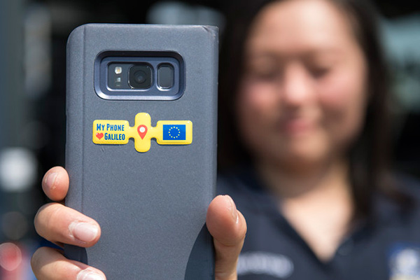
ESA challenged its young graduate and national trainees to develop a smartphone app to perform satnav fixes using only Galileo satellites.
Three teams developed apps in their spare time, presenting their results to a jury of experts from ESA, the European Global Navigation Satellite Systems Agency (GSA) and Google.
“I’m very impressed,” said Javier Benedicto, ESA’s Galileo programme manager. “With little detailed knowledge of satellite navigation, these teams have developed something that didn’t exist just a few months ago. Working on Galileo we love to see that the systems we’re putting together can reach widespread application and inspire new uses.”
The winning Galfins Team put together the GNSS Compare app that promises to turn a smartphone into a “research lab in your pocket” to test Galileo performance in isolation or in combination with other systems. Their prize is to attend an ESA and European Commission-sponsored GNSS Summer School in Austria.
The final presentation and results of ESA’s internal Galileo smartphone app competition took place in the Erasmus centre of ESA’s Erasmus technical centre on May 31. (Photo: ESA)
“Only one of our four-strong team started the challenge with any knowledge about satellite navigation,” said Mateusz Kraiński of the Galfins team. “The rest of us come from different areas — for example, I’m working on the European Robotic Arm project, due to launch at the end of next year. We have learnt a lot and the radio navigation experts at ESTEC were a great source of support.”
“We see a need on the market for such an application, so we will definitely continue with the development. The application will be made available for download when ready, and the project will be released as open source soon after.”
The other two teams were also commended for their work; Chocolateam developed a richly-designed game-based app, giving the user the feeling of observing the Galileo satellites from a spacecraft, while Team 5G distinguished themselves by writing all their own navigation algorithms from scratch rather than relying on open source software.
The challenge was to design an Android smartphone app that allows users to compute and visualize their position based solely on Galileo measurements, as well as the possibility of selecting a combination of satnav constellations to assess their performance.
Testing the three apps entered in the Galileo smartphone app competition in the grounds of ESTEC, working in pedestrian mode. (Photo: ESA)
The receiver chipsets inside smartphones make use of Galileo signals in combination with several other satnav constellations — the U.S. GPS, Russian GLONASS and Chinese BeiDou. These chipsets function like “black boxes,” making the resulting positioning fix accessible to users, but not giving any option for the user to select which constellation to employ.
Current phone applications only display general satnav status information, such as which satellites are contributing to the positioning fix, their visibility parameters and overall power levels. This is not sufficient to single out Galileo’s contribution to the phone’s overall positioning performance.
However, in newer Android smartphones it has become possible to access the raw signal measurements used to compute position, opening the door to the development of applications where the user can indeed select which satellites to use.
The teams received one Galileo-enabled smartphone each for developing and testing the app.
ESA’s Director of Technology, Engineering and Quality supported the teams by supplying dedicated software modules to simplify computations of the phone position. During the competition, a technical advisory team also developed an internal app as a benchmark.
The app, named Galileo PVT and developed by ESTEC engineers Paolo Crosta and Tim Watterton, includes an augmented reality system allowing users to “see” the Galileo satellites from which they were receiving signals in the local sky.
“This was a very useful exercise because it helps us understand the needs of satnav app developers in Android,” said the lead advisor, Paolo Crosta. “Then, once the apps were complete, we tested them together, here on the grounds of ESTEC, working in stationary, pedestrian and vehicular modes.”
“Congratulations to all the teams here today,” said Frank Van Diggelen from Google, who had just come from a satnav raw measurements workshop hosted by GSA. “It’s been great to be here and see all the activity around raw signal measurements. Our aim has always been to raise standards by making these measurements available, to let developers see what’s happening inside. And the work you’re doing here is feeding back to chip and smartphone manufacturers, to help change and improve them for the future.”
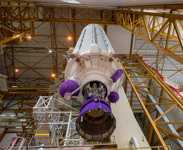
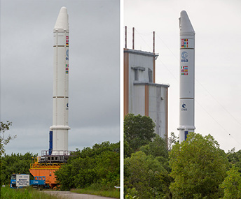
Ariane 5’s cryogenic main stage is moved into position over the mobile launch table inside the Spaceport’s Launcher Integration Building. (Photo: Arianespace)
Four more Galileo satellites will be launched on a customized Ariane 5 on July 25.
The next Arianespace rocket to orbit Galileo satellites has begun taking shape at the spaceport in French Guiana, reported Arianespace. Build-up of the heavy-lift vehicle is now underway inside the spaceport’s Launcher Integration Building.
Following the established assembly flow, the rocket build-up began with this week’s positioning of the launch vehicle’s central core cryogenic stage over one of two mobile launch tables used for Ariane 5.
Ariane 5’s two solid propellant boosters are rolled out. (Photos: Arianespace)
It was followed by integration of the two large solid propellant boosters — installed directly on the launch table and mated to the core stage — clearing the way for placement of the upper stage, topped off with the vehicle equipment bay.
Once the Ariane 5’s basic build-up is completed under the direction of production prime contractor ArianeGroup, it will be moved to the spaceport’s Final Assembly Building for installation of its four Galileo FOC (Full Operational Capability) satellite passengers, which are undergoing their own pre-flight preparations at the spaceport.
The Ariane 5 will deploy its satellite passengers at a targeted orbital altitude of 23,222 kilometers in circular medium Earth orbit. The launch is designated Flight VA244 by Arianespace.
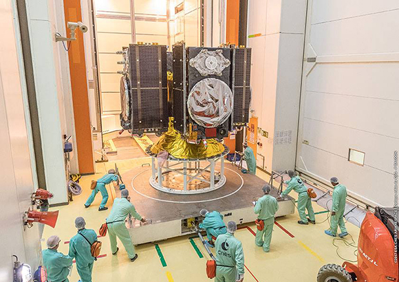
Galileo satellites arrive
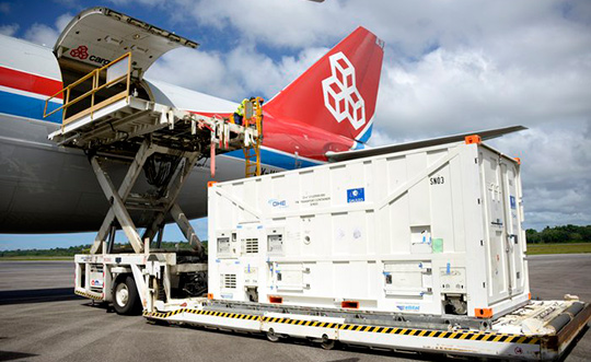
In early June, Galileo satellites 25 and 26 landed at Europe’s Spaceport in Kourou, French Guiana, joining their two predecessors, satellites 23 and 24, according to the European Space Agency (ESA).
One of the two Galileo satellites 25 and 26 is unloaded from a Boeing 747 cargo jet at Cayenne – Félix Eboué Airport in French Guiana on June 1. The satellites travel inside protective air-conditioned containers. (Photo: ESA)
The pair left Luxembourg Airport on a Boeing 747 cargo jet on the morning of June 1, arriving at Cayenne – Félix Eboué Airport in French Guiana that evening.
After they were off-loaded, they were driven by truck to the cleanroom environment of the S1A payload preparation facility at Europe’s Spaceport, still in their protective air-conditioned containers. In the cleanroom, they joined Galileo satellites 23 and 24, which arrived last month.
The cryogenic main stage of the Ariane 5, known as the EPC — from its French title Etage Principal Cryogénique — arrived by sea at French Guiana’s Port Pariacabo on May 30.
A further 12 Galileo “Batch 3” satellites were ordered in 2017, supplementing the 26 built so far to provide further in-orbit spares and replacements for the oldest Galileo satellites, first launched in 2011.
A steady stream of orbital spares, ready to replace satellites reaching the end of their operational lives, is essential to ensure Galileo continues operating seamlessly, according to ESA.
Looking further ahead, with the aim of keeping Galileo services as a permanent part of the European and global landscape, new satellites will be required by the middle of the next decade, offering improved performance and added features.
An increasingly bitter political and economic argument between the United Kingdom (U.K.) and the European Union (EU) has alternately stalled and unfrozen progress on Galileo.
Why does this matter from a defense and security viewpoint? Because it’s all about access to Galileo’s Public Regulated Service (PRS), the military-grade service and signal — in addition to billions of pounds and euros.
The byzantine maneuvering on both sides may have further implications, in the form of a much-expanded role for the current European GNSS Agency (GSA), with a corresponding reduction in funding scope for the European Space Agency (ESA).
ESA is not directly affected by the Brexit brouhaha, but indirectly, the impacts mount and extend. ESA is technically independent of the EU, but acts as the union’s procurement body for space programs. It is run by the 22 member states on the ESA council — which crucially includes the U.K., as well as non-EU members Norway and Switzerland. Thus, the Brits, while exiting the union in March 2019, will continue to play a voting role in the space agency.
In an second-round gambit, the U.K. had threatened to use its veto on the ESA council to delay procurement of future Galileo satellites. This was seen as an attempt to bring the EU into negotiations over U.K. access to the highly encrypted Galileo PRS.
A navigation and timing signal restricted to use by authorized government agencies, armed forces, police, emergency and other security services, the PRS is designed to be robust to jamming and spoofing and available even in times of crisis.
Under EU rules, only EU member states can access or work on the PRS. Similar to GPS M-code, PRS could be said to be the prime motivating factor for the origins of the European GNSS: the desire, some would say the compelling requirement, to have a military-grade signal under one’s own control.
The U.K. says it will encounter “significant gaps” in a wide range of areas including prisoner transfers, asset recovery, sharing of financial intelligence, victim compensation and access to criminal records for child protection vetting, should it be shut out from the PRS. This doesn’t begin to reveal the real reason: the ability to conduct military, security and defense operations confidently undertaken with a secure and enrypted GNSS signal.
The European Commission maintains that the U.K. will have to “apply” to use the PRS, like any other non-EU country, tacitly as a “foreign entity.” PRS is for EU member states only.
U.K. companies such as CGI U.K. have developed much of the programming and coding of the PRS signal. Current EU rules bar all U.K. companies from bidding on new contracts unless they transfer their work to EU countries before Brexit. The EU wants CGI U.K. to hand its encryption security intellectual property to the Franco-Italian firm Thales Alenia Espace.
This would poke Britain’s defense ministry where it hurts most: access to the key source codes, and a measure of security in military, defense and police operations. The U.K. government also wishes to retain the encryption expertise and personnel, rather than see them outsourced.
Four Galileo satellites placed in the payload container prior to December 2017 launch, which brought the total Galileo constellation to 22. (Image courtesy of ESA)
Whither GSA?
In a separate but closely related debate within the EU, a strategic repositioning is proposed for the GSA: renaming and remaking it into the EU Agency for the Space Programme. This would not only greatly enlarge its sphere of activity and authority, it could create two sparring space agencies in Europe, one wholly under the control of the EU and one with the maverick U.K. on its ruling council.
A draft EU document states ESA’s decision-making procedures “cannot lead to a call into question of the decisions of the [European] Commission or the European Space Agency within the framework of the actions and space programmes of the union.”
ESA is naturally bitterly opposed to its parent organization creating a rival. It has long struggled — behind closed doors — with its semi-independent, semi-subservient role to the EU, which after all holds the ultimate purse strings.
Some in Europe see indications that the GSA rebadging could lead to a gradual transfer of space funding from ESA to the newly rechristened agency if EU discontent rises. “A creep in power” was the term used by one official.
The EU has long expressed concerns over ESA’s governance of the funds handed to it by the EU for space projects. The long stall in Galileo getting up a full head of steam, a period that could be said to have extended from 2002 to 2008 or thereabouts, was seen by some atop the EU as evidence of ESA over-extension: technically expert but fiscally untrained or unqualified.
Opening Salvos
In what now appears to be a dead issue, the U.K. had first demanded reimbursement for the €1 billion it contributed to Galileo. The EU rejected that out of hand, saying it would not negotiate “under threat.”
In a follow-up, the U.K. claimed that while it wished to continue participating in Galileo, it could well start up its own GNSS if it did not receive adequate access to Galileo PRS. The EU stuck to its guns, so to speak: “Third countries [and their companies] cannot participate in the development of security-sensitive matters.”
The U.K. has also bruited blocking Galileo from use of ground tracking stations in British overseas territories, such as the Falklands.
A U.K. minister stated: “The U.K. genuinely wants to remain a major player in the project, with privileged ongoing access from outside the EU, and views its capabilities and contribution to date as giving it the right to that ticket.”
A European spokesperson countered: “For the EU, the decision to leave inevitably entails relegation to a different role and status in the project, and, let’s be candid, offers scope for EU-located firms to take contractual business away from U.K. ones.”
The European GNSS Agency (GSA) has issued a request for information (RFI) in preparation for the procurement of EGNOS geostationary navigation payload services.
The EGNOS space segment is provided by commercial satellite operators on the basis of service contracts. The GEO-1, GEO-2 and GEO-3 service contracts now cover the EGNOS space segment needs, and the GEO-1 and GEO-2 services will be the first of these to end, GSA reported. The GEO-1 and GEO-2 services will be replaced by new contracts, GEO-4 and GEO-5.
GSA is planning how it will replace the services delivered by the GEO-1 and GEO-2 satellites, and it’s issuing the RFI to collect information about opportunities to embark navigation payloads on board GEO satellites launched in a suitable time frame.
According to GSA, the results of the RFI will also be used to determine the best approach for the procurement of the payload services, which may be either procured at the same time or separately. It will help GSA define the tender specifications and decide on the most appropriate time to launch invitations to tender.
In addition, GSA aims to obtain information from owners of geostationary satellites that will be available for operational service from 2021 to 2027 and able to embark a navigation payload. The agency is specifically seeking information on future satellite plans and the possibility to embark SBAS payloads in due time to ensure an operational start date from 2021 to 2027.
The RFI will also request information service availability and long-term payload reliability; the process for EGNOS payload procurement, in-orbit testing and commissioning; information on the locations of the potential hosting sites for the EGNOS radio frequency uplink stations; and, finally, information on contractual arrangements, the payment scheme, and cost estimates, GSA added.
Answers to the RFI should be sent electronically to [email protected] by Aug. 31.
UPDATE: The deadline has been extended to July 16.
What technical and business challenges are getting your attention this year? How are you driving business in today’s economy? What issues are you concerned about? What solutions hold the most promise for positioning, navigation and timing (PNT) in challenged and indoor environments — regardless of which technology provides them?
We want to know, and so does the rest of the industry.
Click to enlarge. (Image: GPS World State of the Industry survey)
GPS World is asking PNT professionals about the developing technology frontiers, the state of their business, the economic climate for products and services, driving market factors, the effects of jamming, the Issue of the Year — and more! Please give us your opinions in the 2018 State of the Industry survey. It should take less than 10 minutes, and your responses are confidential.
A handful of lucky participants drawn at random will win:
TWO $100 gift cards good (virtually) anywhere.
Complete the survey by July 16. Then look for a complete report of our findings in the September issue of GPS World.
Thank you for taking the time to share your feedback and help us improve our magazine content, industry awareness — and your own business!
The survey covers such topics as:
Technology Trends. PNT is rapidly diversifying among a number of complementary technologies, as GNSS looks to inertial, lidar, laser, cellular, WiFi and other beacons, signals of opportunity, low-Earth orbit satellite constellations and more. Different market sectors have, naturally, different requirements, and these lead to different integration combinations. Where do you see the most promise?
The Global Economy and how it affects business in your sector. Customers’ availability of capital to invest is top-of-mind for most industry professionals, whether designers, manufacturers, integrators, suppliers/dealers, or end users.
Industry Confidence in the road ahead. Sound business navigation requires a fluid, responsive combination of technology, capital, investment, and often most important, human capital. .
Issues of Concern. To what extent do industry leaders take into account the following as well as further factors?
Pricing and competitive issues;
GNSS jamming, spoofing, other RF interference;
Developing compatibility and interoperability of GNSSs: GPS, GLONASS, BeiDou, Galileo;
Advantages and drawbacks of other positioning and navigation technologies.
The survey, complete with insightful infographics, will appear in the September issue. Look for it!
From left: Ruy Pinto, chief information officer, deputy chief technology officer of SES; André Bauerhin, COO, Spaceopal; Nicole Robinson, SVP Global Government at SES Networks; Etienne Schneider, Luxembourg Deputy Prime Minister, Minister of the Economy. (Photo: SES)
SES will provide a series of services for the Galileo European navigation system under a long-term agreement with Spaceopal, a joint venture between Telespazio and DLR GfR mbH. According to SES, the contract is part of the Galileo Service Operator framework agreement between Spaceopal and the European Global Navigation Satellite System Agency.
Under the agreement, SES will provide Spaceopal with services to support the maintenance and operations of the Galileo Global Navigation Satellite System. Further, SES will be responsible for in-orbit measurements for the Galileo satellite constellation and provide VSAT managed services to Telespazio for the Galileo Data Dissemination Network.
“We are delighted to extend our partnership with SES in the framework of the Galileo Service Operator contract with the European Global Navigation Satellite Systems Agency,” said André Bauerhin, COO of Spaceopal. “SES’s previous success with the Galileo project in delivering and managing services for both in-orbit testing and the Galileo Data Dissemination Network has made SES the clear choice for this operational contract.”
SES also looks forward to the partnership.
“We are proud that we can continue to draw on the experience that we have accumulated while working on Galileo over the years, and continue to be part of the team in ensuring the reliability of the GNSS system and accommodating its shifting demands in the next decade,” said Nicole Robinson, SVP Global Government at SES Networks.
Previously, SES has provided infrastructure and services for the Galileo program, as well as ground stations and in-orbit testing during the In-Orbit Validation Phase.
Mobile brand Xiaomi has launched a dual-frequency GNSS smartphone.
Fitted with a Broadcom BCM47755 chip, the Xiaomi Mi 8 provides up to decimeter-level accuracy for location-based services and vehicle navigation, the company said.
The Mi 8 smartphone represents a breakthrough in GNSS technology as the first commercial deployment of Broadcom’s dual-frequency BCM47755 chip designed for the mass market and introduced in September 2017.
Until now, mobile location-based applications have been powered by single-frequency GNSS receivers whose location accuracy is limited to a few meters. However, in recent years GNSS systems have been launching satellites broadcasting signals on new frequencies to open up new possibilities. Specifically, Galileo has the majority of satellites with E1/L1 and E5/L5 frequency capabilities.
The E1/L1 + E5/L5 GNSS chip can compute location with an accuracy of up to a few decimeters.
Leveraging Galileo for increased accuracy
According to the company, users of the Xiaomi Mi 8 and future models with dual-frequency GNSS will benefit from better positioning and navigation experience in urban environments. This is due to the unique shape of the E5/L5 frequency, which makes it easier to distinguish real signals from the ones reflected by buildings, reducing the multipath effect, a major source of navigation error in cities and other challenging environments.
The numerous Galileo satellites broadcasting E5 make this improvement available for users all around the world. In addition, the simultaneous use of two frequencies reduces other sources of error, such as those due to the ionosphere, and the frequency diversity is more robust to interference and jamming.
In addition to making existing applications more accurate, the enhanced position precision offered by dual-frequency GNSS will also create opportunities for new applications in areas such as augmented reality, vehicle navigation and mapping.
Commenting on the product launch, European GNSS Agency (GSA) head of market development Gian Gherardo Calini said that the arrival of the first dual-frequency GNSS smartphone to the mass-market represents a breakthrough for users all over the world.
“The enhanced accuracy provided will empower developers to create new applications that meet the growing high-accuracy location requirements of users and also open up applications that previously only ran in dedicated devices intended for professional use,” Calini said.
“Broadcom is glad to gear up Xiaomi’s flagship smartphones with the very latest dual-frequency GNSS technology,” added Alex Chou, vice president of product marketing for the Wireless Communications and Connectivity Division at Broadcom. “Xiaomi Mi 8, the world’s first smartphone with BCM47755, will take smartphone GNSS navigation to a whole new performance level.”
”The importance of GNSS to modern life is undisputed, and is particularly important for smartphones,” said Zhiyuan Zang, Xiaomi’s director of product marketing. “Navigation and LBS-based apps these days require greater positioning accuracy to work effectively, and dual-frequency GNSS is the key to delivering a great user experience when using these apps. Xiaomi is delighted and honored to be the world’s first smartphone manufacturer to support dual-frequency GNSS. We will continue to pursue innovation for everyone to enjoy.”
Access to raw measurements for geolocation
The launch of the first dual-frequency GNSS smartphone, together with the opportunities offered by the availability of GNSS raw measurements in Android, creates exciting opportunities for the geolocation community, the company said.
Access to raw measurements opens the door to algorithms once restricted to more advanced GNSS receivers. This, in turn, allows users to fully benefit from the differentiators offered by Galileo.
Recognizing these opportunities, in 2017 the GSA engaged with academia and industry in the areas of navigation and positioning to innovate around this new feature as part of a GNSS Raw Measurements Task Force.
Then, in January, the GSA published a white paper on the use of GNSS Raw Measurements in Android, providing developers with in-depth information on accessing and using raw measurements to implement advanced GNSS techniques in mass-market devices.
Building on this work, the GSA and the Raw Measurements Taskforce shared their latest updates at a dedicated workshop — “GNSS Raw Measurements: From Research to Commercial Use” — held at the GSA headquarters in Prague on May 30, where Broadcom presented its encouraging test results from the dual-frequency BCM47755.
 The Trimble Catalyst software-defined GNSS receiver for Android phones and tablets has been updated to support GLONASS. The update demonstrates the advantages of software GNSS for delivering new functionality faster and easier, according to Trimble.