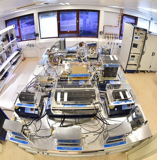
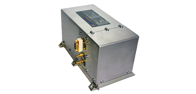
Harris Corporation has provided Lockheed Martin with its fifth of 10 advanced navigation payloads contracted for the U.S. Air Force GPS III satellite program.
The GPS III navigation payload features a Mission Data Unit (MDU) with a 70-percent digital design that links atomic clocks, radiation-hardened computers and powerful transmitters — enabling signals three times more accurate than those on current GPS satellites, the company said.
The payload also boosts satellite signal power, increases jamming resistance by eight times and helps extend the satellite’s lifespan.
Lockheed Martin successfully integrated the navigation payload into the fifth GPS III space vehicle (GPS III SV05). Harris is committed to delivering three more payloads by the first quarter of calendar year 2019 for GPS III SVs 06-08.
Four navigation payloads have already been fully integrated on GPS III SV01-SV04. In September 2017, the Air Force declared the first GPS III satellite Available for Launch (AFL) with launch expected later in 2018.
In December 2017, GPS III SV02 completed rigorous thermal vacuum testing and is expected to be declared AFL this summer. GPS III SV03 and SV04 are expected to undergo environmental testing this year.
In November 2017, Harris announced that it completed development of an even more-powerful, fully digital MDU for the Air Force’s GPS III Follow On (GPS IIIF) program. The new GPS IIIF payload design will further enhance the satellite’s capabilities and performance for the Air Force.
Harris’ expertise in creating and sending GPS signals extends back to the mid-1970s — providing navigation technology for every U.S. GPS satellite ever launched. While the Air Force originally developed GPS for warfighters, millions of people around the world and billions of dollars of commerce now depend on the accurate, reliable signal created and sent by Harris navigation technology.
China has already launched eight BeiDou-3 satellites for its domestic BeiDou Navigation Satellite System. The satellites will provide initial services for countries and regions along the Belt and Road by the end of the year, said Wang Li, chairman of the China Satellite Navigation System Committee.
Addressing the Ninth China Satellite Navigation Conference in Harbin, capital of northeast China’s Heilongjiang Province, Wang said the BeiDou system is moving to become a global service provider after offering stable and reliable time and space information for clients in the Asia-Pacific region.
China launched the first two BeiDou-3 satellites into space via a single carrier rocket in November 2017, as its self-developed BeiDou system officially began to expand into a global network.
Compared to earlier generation satellites, the BeiDou-3 is able to send signals that are more compatible with other satellite navigation systems and provide satellite-based augmentation, as well as search-and-rescue services in accordance with international standards. Its positioning accuracy has reached 2.5 to 5 meters.
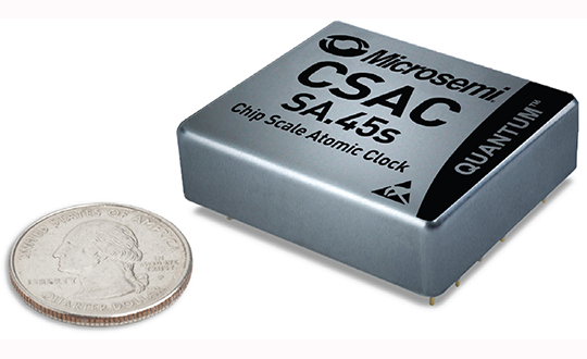
The device provides the accuracy and stability of atomic clock technology while achieving significant breakthroughs in reduced size, weight and power (SWaP) consumption, the company said.
As the newest member of Microsemi’s CSAC product family, the Commercial Space CSAC provides excellent drift performance and built-in 1 pulse per second (PPS) input for GPS disciplining, making the device well-suited for holdover applications.
It is targeted at several other commercial space and space research applications, including:
satellite timing and frequency control;
satellite cross linking;
assured position, navigation and timing; and
Earth observation.
With many spacecraft manufacturers turning to commercial off-the-shelf (COTS) parts to meet performance, schedule and cost requirements, the Commercial Space CSAC offers a solution for many satellite missions.
“With the introduction of the Commercial Space CSAC, we now offer a space-deployable atomic precision clock reference with radiation tolerance in support of the space market’s desire to reduce mission costs and design times using COTS devices,” said Peter Cash, director of the clock business unit at Microsemi. “As the first atomic reference clock with low SWaP available for space, our new device is well-suited to applications requiring precise clock synchronization, including a variety of existing and emerging LEO applications.”
According to a market intelligence report by Euroconsult titled, “Satellites to be Built & Launched by 2026 World Market Survey,” the total revenue for satellite manufacture and launch is expected to be $304 billion between 2017-2026. With revenues of $102 billion, LEO is expected to account for a third of the total market, with 82 percent derived from satellite manufacturing.
“Harris provides the world’s most advanced sensors, payloads and communications technologies; receiving and information processing systems; and analytics, which provide our customers with the integrated information and actionable intelligence they need for mission and business success,” said Tim Lynch, general manager, Mission Solutions at Harris Corporation’s Space and Intelligence Systems segment. “Microsemi’s latest atomic clock will support Harris in delivering complete mission solutions to our customers.”
As a stand-alone atomic clock with a 10-megahertz CMOS-compatible output, Microsemi’s Commercial Space CSAC is a timing module providing an impressive short-term stability (Allan Deviation) and frequency stability across the operating temperature (TempCo), the company added.
A standard CMOS-level RS-232 serial interface is built into the device, which is used to control and calibrate the unit and provide a comprehensive set of status monitors. The interface is also used to set and read the CSAC’s precise internal time-of-day clock.
Microsemi’s radiation-tolerant ruggedized oscillators also include OCXOs and EMXOs for applications that require higher accuracy and can support higher power consumption.
Other key features include:
Power consumption of less than 120 milliwatts (mW)
Less than 17 cubic centimeters volume (1.6 in. × 1.39 in. × 0.45 in.)
Radiation-tolerant: 20 krad
Single event latch-up (SEL) and single event upset (SEU) tested to 64 megaelectron-volts per square centimeter/milligram (Mev-cm2/mg)
Short-term stability (Allan Deviation) of 3.0 × 10⁻¹⁰ at TAU = 1 sec
Frequency stability across temperature range (TempCo) less than 5×10⁻¹⁰
1PPS output and 1PPS input for synchronization and time-keeping
The International Navigation Conference, sponsored by the Royal Institute of Navigation (RIN), is a premier forum for the presentation of research and advances in navigation.
The 2018 conference — the RIN’s fourth — will take place Nov. 12-15 in Bristol, England, United Kingdom.
INC2018 brings together industry, academia and governments from around the world. The theme for INC2018 is “Navigation Challenges and Societal Benefits.”
Eight years on, and the money generated by a hedge fund still seeks to destabilize the Global Positioning System and the billions of people who benefit from it, whether they create it, administer it, sell it or use it.
That accounts for just about everybody touched by telecommunications and the industrial network, including the brave individuals serving in the military.
For rewards to the few, the U.S. government is lobbied to levy hardship on the many. In the service of that lobbying, the truth is manipulated to suit the ends. Sound familiar?
See this article for facts and findings of years of detailed study of this matter, recounted in the recently released Department of Transportation’s Adjacent Band Compatibility (ABC) Assessment Final Report. That it appears almost a year after all the research and nearly all the analysis was completed suggests that powerful forces are at work, perhaps warring with each other, within the government. Let us hope that the guys and gals with the good hats on can prevail.
The matter now rests with the Federal Communications Commission, an appointed panel not subject to the electorate nor to Congress, whose decisions sometimes carry a scent of influence from hidden quarters. Note particularly the recent ruling against net neutrality, which most agree runs counter to public interest and correlative with private corporate interests.
As our news story states, the ability to use the mobile satellite services (MSS) band for terrestrial services is “limited.” The DOT ABC Assessment, using the 1-dB Interference Protection Criterion of a 1-dB drop in carrier-to-noise density ratio that’s accepted by everybody — specifically, every engineer — on Earth except Ligado Networks, demonstrates conclusively there is no chance the company could actually deploy a viable commercial terrestrial service in the MSS spectrum without disrupting or degrading vital GPS and GNSS services.
The U.S. government and the GPS industry have both expended far too much money and time trying to accommodate a force-fit of a non-compatible use into the bands adjacent to the radionavigation satellite service band, to the benefit of one commercial company’s bottom line.
It’s high time for this nonsense to stop. Nobody, least of all the government and the GNSS industry, owes Ligado anything.
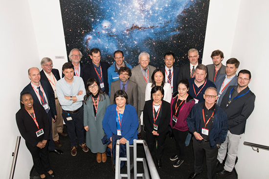
Delegates from the UN’s International Committee Global Navigation Systems (UN ICG) at the entrance to ESA’s ESTEC Test Centre, used to test the last 22 Galileo satellites. (Photo: ESA)
The UN ICG group visited ESTEC on May 16 during a meeting in the Netherlands.
News from the European Space Agency (ESA)
Members of the United Nations (UN) technical group supporting global cooperation in satellite navigation toured ESA’s technical centre in the Netherlands to see key facilities used to develop Europe’s Galileo system.
Delegates from the UN’s International Committee on Global Navigation Systems (UN ICG) met in mid-May at the nearby Galileo Reference Centre, operated by the GSA, European Global Navigation Satellite Systems Agency.
ESA, one of the founding members of the ICG in 2005, invited them to visit the agency’s European Space Research and Technology Centre, ESA’s single largest establishment and home to its Navigation Directorate.
Javier Benedicto, ESA’s Galileo program manager was joined by Rodrigo Da Costa, GSA’s Head of Exploitation, in giving the visitors a hearty welcome. “I’m honored to work with the amazing team of engineers and managers responsible for developing the Galileo system,” Benedicto said. “The laboratory and testing facilities here are very much at the heart of Galileo development.”
ESA’s Receiver Testing Facility is the historic location of the first Galileo positioning fix in 2012. (Photo: ESA)
“I’m very happy to welcome members of the UN ICG group, doing a great job in bringing navigation satellite system operators together, to share achievements and challenges and encourage interoperability – our users love our systems working together.”
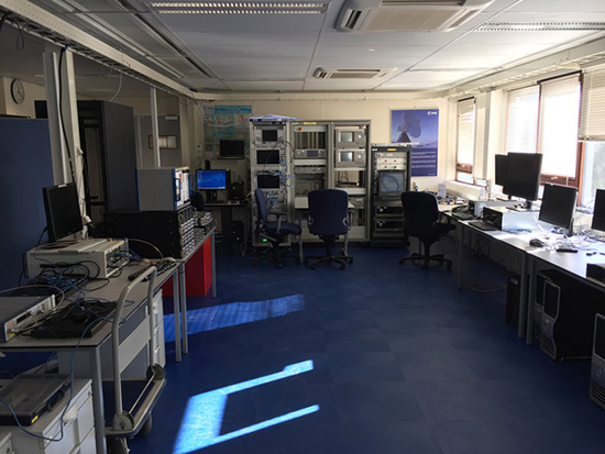
The tour began at ESA’s Receiver Testing Facility — historic location of the world’s very first Galileo positioning fix back in 2012 – equipped with a multitude of specialized satnav receivers for not only Galileo satellites but also the US GPS, Russian Glonass, Chinese BeiDou, India’s NAVIC and Japanese QZSS systems, together with augmentation systems such as Europe’s own European Geostationary Navigation Service, EGNOS. The signals from all these systems can also be recorded to very high fidelity for subsequent investigation or reuse.
Lab simulation systems can recreate all these outputs in combination to test receiver systems across a huge range of scenarios, such as amid interference induced by a solar storm, or to see how receivers cope while flying, or even in orbit.
Smartphone receivers can be assessed with simulated augmentation from cellular network stations, wifi mapping or inertial navigation, while simulating their user’s continuous motion. The flexibility the facility’s simulators offer also allows early testing of enhancements planned for next decade’s ‘Galileo Second Generation’ satellites.
“Our aim is to go closer to the market, and how they’re doing things because how current services are being exploited is very important for developing the next generation,” said Olivier Smeyers of ESA’s Commercial User Segment Section.
This table in ESA’s Galileo Payload Laboratory comprises a replica Galileo In-Orbit Validation satellite payload (other than its atomic clocks, which are housed separately nearby). Kept in cleanroom conditions at ESTEC in the Netherlands, it is employed for ground-based testing or anomaly investigation. (Photo: ESA)
Next came the Galileo Processing Centre, which provides ESA with continuous monitoring of Galileo services. It functions independently from the rest of the global Galileo infrastructure, to allow independent assessment of its performance, down to individual satellites and the onboard atomic clocks at the heart of the system — working closely with facilities such as the Galileo Time Validation Facility in Spain and the Galileo Control Centres in Germany and Italy.
The group was also shown ESA’s Time and Metrology Facility: an ensemble of six high-performance atomic clocks sufficiently stable to monitor the nanosecond-scale performance of Galileo System Time, and since 2012 maintaining their own timescale called UTC (ESTC), employed in turn to help set Coordinated Universal Time (UTC) — the world’s global time.
The cleanroom environment of the Galileo Payload Laboratory contains the same atomic clocks flown aboard Galileo satellites with the rest of its navigation payload, used to replicate any performance anomalies identified in orbit and make early tests of Galileo Second Generation design improvements.
“ESA is a very active member of UN ICG,” commented Rafael Lucas Rodriguez of ESA’s Galileo Services Engineering Unit and tour organizer. “We’re currently co-chairing an ICG working group on system performance enhancement and supporting the European Commission and GSA on all Galileo-related technical matters discussed at the committee.”
An aerial view of ESTEC. The Erasmus building is at front right. The T building (home to ESA’s Galileo team) is in the foreground.
Orolia’s atomic clock solutions have been selected for the Galileo Global Navigation Satellite System (GNSS) under contracts totaling 26 million euros for an additional 12 Galileo satellites.
This latest initiative builds on Orolia’s long-standing role in providing precise timing technology for satellite programs, including Galileo.
Each satellite will carry two rubidium atomic clocks and two passive hydrogen masers, considered the most stable clock in the world. Under these contracts, Orolia will supply its Spectratime Rubidium Atomic Frequency Standard and its passive hydrogen masers physics package.
Orolia’s Space Rubidium Atomic Frequency Standard. (Photo: Orolia)
“We’re honored to continue supporting the European Commission with precise timing for Galileo,” said Orolia CEO Jean-Yves Courtois. “These new contracts further emphasize Orolia’s position as the world’s leading provider of resilient positioning, timing and navigation (PNT) solutions.”
In addition to serving as Europe’s independent PNT source, Galileo can also serve as a secondary signal source for systems such as GPS, GLONASS or BeiDou in the event of service disruption. Galileo’s quadruple clock redundancy designed into each satellite ensures that even if a failure occurs, overall system performance will not be compromised.
More than 150 Orolia Spectratime atomic clocks are flying to support Galileo, IRNSS, BeiDou, GAIA and other missions, some for more than 10 years. Orolia provides the expertise necessary to design solutions for highly reliable space applications.
Orolia is a designer and manufacturer of a full range of high-performance, low-cost GNSS synchronized crystal solutions, rubidium and maser sources, smart integrated GNSS reference clocks, rugged PNT devices, GNSS simulation and clock testing systems. Orolia’s PNT solutions support a variety of critical applications including defense, government, space, maritime, enterprise networks, aviation and telecommunications.
The United Kingdom and the European Union (EU) continue locked in conflict over Galileo post-Brexit, much akin to a divorce dispute over the children.
The European Commission has initiated proceedings to exclude the U.K. and its companies from security work on Galileo before the country’s exit from the bloc next year, a move that presages exclusion from use of the security features of the Galileo PRS signal.
The U.K. has responded with a demand for repayment of up to 1 billion pounds ($1.34 billion).
Both sides say they wish to continue working together on the GNSS, but the EU insists that it must be under new rules, including those preventing third countries from obtaining access to critical security information. The European Commission, executive arm of the EU, says the U.K. can no longer be trusted with sensitive data providing a secure back-up for the new satellite system.
“It’s simple: Britain is part of Galileo today as an EU member, but won’t be automatically part of Galileo tomorrow as a third-party state,” said an EU advisor. “That’s the mechanical, legal consequence of Brexit.”
The U.K. for its part has made unrestricted access a condition for a broader security collaboration.
There has been speculation that the U.K. would use the $1.34 billion alimony settlement to build a new GNSS, drawing on expertise from Australia — in effect, engendering offspring from a new marriage.
The culmination of several years of test and analysis conducted by the U.S. Department of Transportation, the assessment will play a key role in the Federal Communications Commission’s upcoming decision on a proposal from Ligado Networks.
The long-awaited Final Report for the U.S. Department of Transportation’s Adjacent Band Compatibility (ABC) Assessment was released on April 26.
The report is the culmination of several years of test and analysis conducted by the DOT, with input and assistance from the public and federal agency stakeholders. Though not explicitly motivated by it, the assessment appears to be responsive to the Positioning, Navigation, and Timing (PNT) Executive Committee’s (EXCOM’s) Jan. 13, 2012, memorandum to the National Telecommunications and Information Administration (NTIA) that sought to develop metrics to inform commercial non-space proposals for use of frequency bands adjacent to those used by GPS, so that existing and evolving space-based PNT services “vital to economic, public safety, scientific and national security needs” were not affected by implementing such proposals.
The assessment will likely play a key role in the Federal Communications Commission’s upcoming decision on a proposal from Ligado Networks to add an extensive complex of powerful ground transmitters to its system, broadcasting on frequencies allocated for satellites.
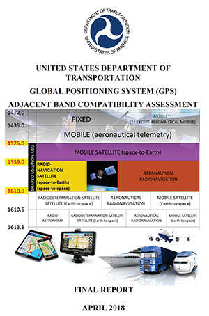
Open and Transparent. Two key attributes of the ABC assessment were that it was conducted openly and transparently, with numerous public workshops announced via the Federal Register, and it was agnostic to any particular proposal for use of bands adjacent to GPS/GNSS services. The approach chosen by DOT in performing its assessment was to develop maximum tolerable effective isotropic radiated power (EIRP) levels that could be transmitted at differing frequency offsets from the GPS L1 center frequency.
The term “adjacent” in this regard is a bit of a misnomer in that the assessment range extended to 100 MHz on either side of the GPS L1 center frequency of 1575.42 MHz. This approach was recently validated by the National PNT Systems Engineering Forum (NPEF), which found the ABC assessment was the only one of five test and analysis efforts conducted since 2011 on adjacent-band terrestrial operations that met all six of the test criteria recommended by the experts serving on the National PNT Advisory Board. The NPEF analysis is available here.
Measurements on 80 civil GNSS and GPS receivers were performed at White Sands Missile Range (WSMR) in New Mexico. The Air Force conducted a prior week of testing on military GPS receivers at WSMR, and while the results of that testing are classified, an Air Force briefing at the November 2017 PNT Advisory Board meeting indicated the military receiver test results supported the conclusions drawn by the DOT ABC assessment. Certified aviation GPS/GNSS receivers were analyzed by RTCA Inc. and are being analyzed by the FAA in terms of determining power levels in adjacent bands that don’t exceed FAA Technical Standard Orders. However, the overall ABC assessment indicates that certified aviation receivers are not the limiting case for tolerable interference from adjacent-band services to GPS and GNSS receivers.
Test Procedures
Compatibility assessment for the civil receivers consisted of conducting the initial measurements at WSMR for six categories of receivers: aviation (non-certified), cellular, general location/navigation, high-precision, timing, and space-based receivers. These were evaluated to determine what DOT called Interference Tolerance Masks (ITMs) for each category of receiver and each receiver tested. The ITMs define the maximum aggregate interfering power that can be tolerated by a given GPS or GNSS receiver. The ITMs are based on the internationally accepted Interference Protection Criterion (IPC) of a 1-dB drop-in carrier-to-noise density ratio (C/NO) for the receiver, or, equivalently, an interference density-to-noise ratio (IO/NO) of –6 dB. This 1 dB IPC standard, which NTIA directed to be used in the NPEF evaluation of the original LightSquared (now Ligado) adjacent-band proposal in late 2011, is explained in great detail in a white paper the Air Force made publicly available in 2017.
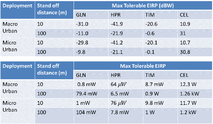
The assessment then developed, with input from the public at several workshops convened by the DOT, use cases to determine how close a receiver for a particular GPS or GNSS application might be to a base station or handset of a commercial terrestrial service in an adjacent band. Proximity distances of 10 and 100 meters were selected from these use cases, and maximum tolerable transmit EIRP levels for a given frequency offset were determined; see Figure 1. The high-precision receivers (HPRs) were the most susceptible to interference from terrestrial operations in the adjacent bands.
Figure 1. Maximum tolerable power level for GPS/GNSS receivers at 1530 MHz. (Table: DOT)
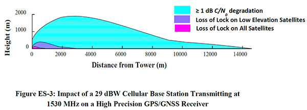
One thing that seems clear is that, with tolerable transmit power levels in the milliwatt and microwatt range, the potential to use the bands near GPS frequencies for commercial terrestrial wireless services may be limited. Illustrating that point further, the assessment shows that, based on the assumptions in the study, HPRs can be affected at distances beyond 14 kilometers (see Figure 2), and that loss of lock for low-elevation satellites can occur at distances of up to 3 kilometers from a base station providing terrestrial services using characteristics adopted internationally in the International Telecommunication Union (ITU) study groups.
Figure 2. Impact of a 29-dBW cellular base station transmitting at 1530 MHz on a high-precision GPS/GNSS receiver. (Chart: DOT)
Moreover, the assessment determined that the potential interference to other GNSS systems may be more problematic, noting that “the levels that protect all GNSS signals can be as much as 15 dB lower than those needed to protect L1 C/A signals from base station emissions with an average difference of 3.5 dB across all frequencies and five categories considered.”
Galileo’s Role. Since 2013, according to a Public Notice from the FCC, the European Commission has sought a waiver of FCC rules that require licensing of receivers operating with foreign satellites so that Galileo service can be provided in the United States. The FCC has yet to act on this waiver request, which was issued in a January 2017 Public Notice, despite overwhelming public support and a positive recommendation from the Executive Branch in 2015.
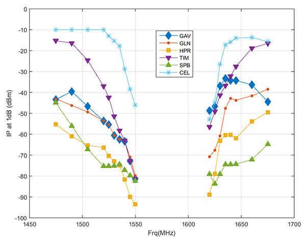
Figure 3. Bounding masks for each category corresponding to the 10 MHz LTE interference signal and L1 C/A GPS signal: general aviation, general location and navigation, high precision, timing, space-based, cellular. (Graph: DOT)
Conclusions
It is well known that all receivers take in some power from signals transmitted in nearby frequency bands. Considering this fact, the ABC assessment is relatively unique in that it examines the overall spectral environment in which GPS/GNSS operations can be affected rather than just the band allocated to the Radionavigation-Satellite Service (RNSS, the broad radiocommunication service defined in the ITU and in domestic rules under which GPS and other GNSS systems operate) between 1559–1610 MHz. That the overall environment should be considered is an important aspect of any discussion of protecting GPS and other GNSS services given the U.S. National Space Policy that was signed into effect June 28, 2010, that directs the U.S. government to “take necessary measures to sustain the radiofrequency environment in which critical U.S. space systems operate.” This policy is still in effect, and it would be difficult to argue that GPS is not a critical U.S. space system.
Recently, the reconstituted National Space Council adopted four recommendations, one of which related to spectrum used for satellite services and said that NTIA should coordinate with the FCC to ensure “the protection and stewardship of radio frequency spectrum necessary for commercial space activities.” Stewardship that is consistent with National Space Policy would include sustaining the RF environment for GPS.
As the PNT EXCOM has made clear, GPS is “vital to economic, public safety, scientific, and national security needs” of the U.S. Moreover, economic analysis presented to the PNT Advisory Board in 2015 estimated the economic benefit to the nation of GPS services at over 68 billion dollars annually. With the release of the ABC assessment, definitive information is now available to inform decisions on use of frequencies near those used to provide space-based PNT services so these critical services are not disrupted or degraded.
The Galileo Reference Centre (GRC), the new state-of-the-art performance monitoring hub for the European Union’s global satellite navigation system, was officially inaugurated May 16 in Noordwijk, the Netherlands.
The ceremony was presided by Dutch Minister of Infrastructure and Water Management Cora van Nieuwenhuizen and European GNSS Agency (GSA) Executive Director Carlo des Dorides, among others.
GSA Executive Director Carlo des Dorides (right), Dutch Minister for Infrastructure and Water Management Cora van Nieuwenhuizen, and DG GROW Deputy Director-General Pierre Delsaux at GRC inauguration. (Photo: GSA)
“The Galileo Reference Centre is a state of the art facility that underpins Galileo service provision,” des Dorides said. “The GRC will be instrumental in monitoring the performance of the system and of the service operator, ensuring that users benefit from the most reliable satellite data and, at the same time, disclosing new service potential.”
“I am proud of the fact that the Galileo Reference Centre is located in the Netherlands,” van Nieuwenhuizen said. “The data provided by Galileo will enable us to navigate with an accuracy to within 20 centimeters. In rescue operations, this sharp reduction in response time is going to save human lives.”
Independent monitoring ensures quality for users
The GRC is a cornerstone of service provision for Europe’s Galileo satellite constellation and plays an important role in Galileo’s operations, providing the GSA with an independent means of evaluating the quality of the signals in space and the performance of the Galileo Service Operator (GSOp). In so doing, it helps ensure the provision of high-quality satellite data so users can better rely on and benefit from Galileo.
Managed by the GSA, the GRC is comprised of a core facility in Noordwijk and contributions from EU Member States, Norway and Switzerland. From the core facility, the GRC generates performance evaluation products and reports using data collected in-house and through cooperation with Member States. The Centre also performs dedicated campaign-based analyses to support investigation of any service performance issues and reports on its findings.
In this two-pillar approach, the GRC benefits from and contributes to maintaining long-term competence and expertise at the Member State level, and actively integrates contributions from the EU Member States, Norway and Switzerland to support daily operations and specific campaigns.
The GSA has established agreements with two beneficiaries, one led by the French Space Agency (CNES) and the other by the Netherlands Aerospace Centre (NLR), and 23 organizations from 14 different countries. Member State contributions include data from networks of reference stations and campaigns using vehicles, vessels and airplanes, and reference products.
The GRC is fully independent of the system and the Galileo Service Operator with respect to its operations.
Since June 2017, GRC operations were hosted and operated from a temporary facility at ESTEC, the neighbouring ESA technical centre, which was instrumental in the swift ramp-up of competences. In April the GRC moved to its new home.
Earlier in May, the GRC hosted representatives from US GPS, Russian Glonass, Chinese BeiDou, Japanese QIS and Galileo to discuss the creation of an authoritative international GNSS monitoring and assessment system to benchmark the performance of available GNSS. The meeting was organised through the International GNSS Monitoring and Assessment Task Force of the United Nations Office of Outer Space Affairs (UNOOSA), International Committee on GNSS (ICG).
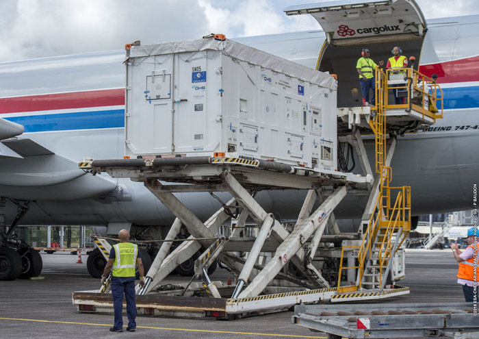
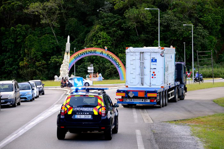
The next two satellites in Europe’s Galileo satellite navigation system have arrived at Europe’s Spaceport in Kourou, French Guiana, ahead of their planned launch from the jungle space base in July.
Galileo satellites 23 and 24 left Luxembourg Airport on a Boeing 747 cargo jet on the morning of May 4, arriving at Cayenne – Félix Eboué Airport in French Guiana that evening.
Arrival at the Felix Eboué airport on April 5, 2018. (Photo: ESA)
They were then unloaded, still in their protective air-conditioned containers, and transported by truck to the cleanroom environment of the preparation building within Europe’s Spaceport.
This pair will be launched along with another two Galileo satellites, which are due to be transported to French Guiana later this month.
The quartet will be launched together on a customized Ariane 5 on July 25.
The Galileo System began Initial Services on Dec. 15, 2016, and a growing number of commercial devices are using Galileo today. Completion of the constellation should improve Galileo’s positioning accuracy further still.
One of two Galileo satellites being driven by truck to the Guiana Space Centre inside its container. Galileo satellites 23 and 24 left Luxembourg Airport on a Boeing 747 cargo jet on the morning of May 4, arriving at Cayenne – Félix Eboué Airport in French Guiana that evening. (Photo: ESA)
But Galileo satellites will continue to be launched into the future: a further 12 Galileo “Batch 3” satellites were ordered last June, supplementing the 26 built so far to provide further in-orbit spares, and replacements for the oldest Galileo satellites, first launched in 2011.
A steady stream of orbital spares, ready to replace satellites reaching the end of their operational lives, is essential to ensure Galileo continues operating seamlessly.
Looking further ahead, with the aim of keeping Galileo services as a permanent part of the European and global landscape, replacement satellites will be required by the middle of the next decade, offering improved performance and added features.
Trimble has announced version 4.1 of Trimble Business Center office software that enables surveyors and geospatial professionals to simplify the creation of cadastral, GIS, infrastructure inspection and tunneling deliverables.
With the version 4.1 update, GNSS field data from GIS receivers (including the Trimble Geo 7X) can now be post-processed within Trimble Business Center to achieve high-quality feature locations. This allows enterprise-level organizations the flexibility to integrate both GIS and survey data within the same project environment and then link the high-quality locations directly to their Esri geodatabase.
Version 4.1 also provides seamless integration with Trimble Access 2018 field software to improve field-to-office productivity using new cloud-based data synchronization and workflow task management capabilities.
Version 4.1 adds new cadastral capabilities including proportioning, map checking and CAD drafting tools that streamline the creation of survey plans, plots and survey engineering digital deliverables.
For infrastructure inspection, construction as-built verification and volumetric applications, new projected surface tools enable professionals to analyze and compare data captured in the field against design. Point clouds from the Trimble SX10, Trimble VISION instruments, 3D laser scanners and unmanned aircraft system (UAS) platforms can be used for slope monitoring as well as to perform accurate volumetric, deformation and cut/fill analysis for retaining wall, dams and mining applications.
A new optional Tunneling Module enables survey and engineering professionals to simplify their workflow and improve productivity to meet time-sensitive deadlines for tunnel construction projects. Tunnel designs can be created and exchanged with Trimble Access field software, enabling customers to easily stakeout tunnel elements in the field and quickly produce as-built analysis and reports in the office.