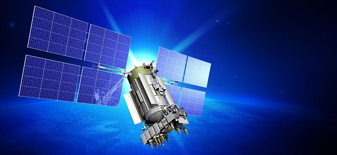
Lime Microsystems and Airbus Defence and Space, with funding from Innovate UK (formerly the Technology Strategy Board), will jointly be developing robust GNSS products, according to a Lime Microsystems blog. Airbus D&S, using Lime’s Field Programmable RF (FPRF) transceiver technology, is developing a robust timing receiver that exploits signals from the new Galileo satellite navigation constellation.
A highly integrated Field Programmable RF (FPRF) solution based on Lime’s technology, and an innovative system implementation of the kind provided by Airbus D&S, will provide a high-performance GNSS product with the potential for integration with other wireless capabilities, the companies said.
“Lime FPRF transceiver matches our rigorous technical performance requirements and we are looking forward to be working alongside Lime in this strategic engagement,” said Mike Turner, Airbus D&S.
“We are delighted to be working with Airbus, supporting a complimentary technology that could impact variety of applications such as wireless infrastructure,” said Ebrahim Bushehri, CEO of Lime Microsystems.
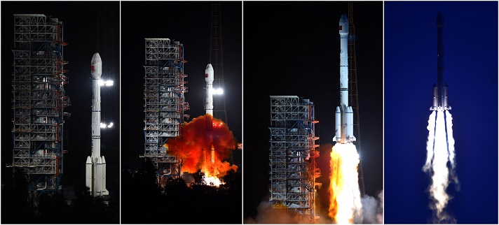
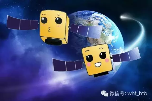
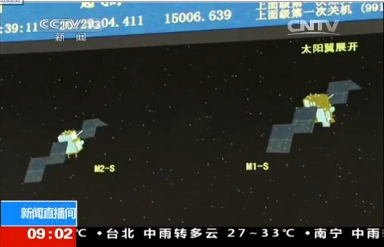
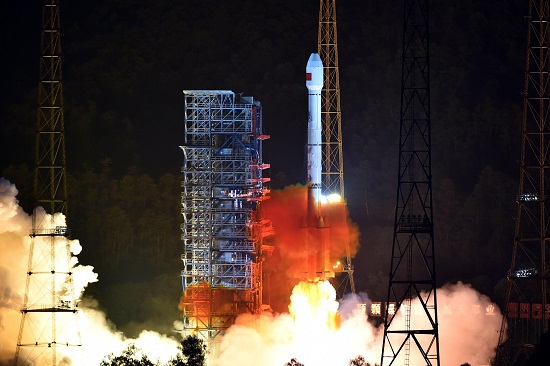
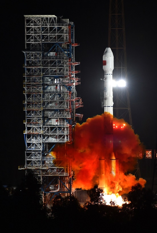
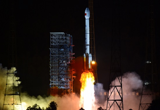
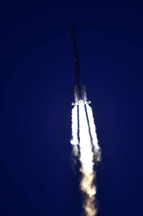
The two BeiDou satellites launched July 25 are now operating autonomously, according to the news site English.news.cn. The satellites were launched by a Long March III-B rocket from the Xichang Satellite Launch Center in Sichuan Province, southwest China. The twin satellites, dubbed BEIDOU-3 M1 and BEIDOU-3 M2, surpass their predecessors in speed, accuracy and weight, according to the news agency.
China has successfully tested the autonomous control technology of the Beidou constellation, said to Xie Jun, chief designer of Beidou navigation satellite system. “The biggest difficulty is the autonomous navigation technology,” Xie said. “We need it to maintain the sustainable development of the project.”
Wang Ping, another chief engineer on the project, says the inter-satellite link realizes communication and distance measurement among satellites, bringing autonomous control of the navigation system a step closer.
China plans to set up a complete constellation of 35 satellites, achieving global coverage by 2020.
Registration is now open for the International Symposium on GNSS (IS-GNSS 2015), which will be held Nov. 16-19 in Kyoto, Japan. The early bird registration deadline has been extended and closes Aug. 31, and regular registration is Sept. 1-Oct. 31.
The International Symposium on GNSS is designed to bring together experts engaged in PNT and GNSS technologies — including industry professionals, practitioners, academics and researchers — to disseminate their latest research results and allow cross-disciplinary exchange of knowledge to further advance the fields.
Brad Parkinson will deliver the keynote address. Besides keynote addresses, the conference will feature oral presentations, interactive poster sessions, panel sessions, open interactive forums and an informative trade exhibition.
The Asia and Pacific Rim meeting of the CGIC (Civil GPS Service Interface Committee) will be co-located with ISGNSS 2015 to help improve understanding of world trends in developing and deploying GNSS.
Kyoto is the ancient capital of Japan and a top tourist destination, organizers said, with the conference scheduled during the best sightseeing season.
Registration will open April 1, along with a hotel booking page. The logistic information will be announced later.
A student scholarship is being offered to the student with the most promising paper. “If you have students, please encourage them to apply,” said Akio Yasuda, president of Institute of Positioning, Navigation and Timing of Japan.
The Canadian government will begin providing search-and-rescue repeaters for the U.S. Air Force’s GPS III satellites, reports Space News. The repeaters provided by Canada’s Medium Earth Orbit Search and Rescue (MEOSAR) satellite project will significantly reduce the time it takes to locate a distress signal.
Canada’s Department of National Defence will begin negotiations with the U.S. Air Force to install 24 repeaters on GPS III satellites, starting with the 11th GPS III satellite. Canada’s MEOSAR satellite project includes construction of three ground stations, to be built by 2020.
The MEOSAR satellite payload is being developed for GPS III satellites.
The Canadian government first announced the MEOSAR project in 2013, awarding Com Dev International of Cambridge, Ontario, an initial contract worth 4.7 million Canadian dollars for research and design work on the repeaters. Despite completion of that phase, Canada’s Department of National Defence put the project on hold, possibly for budgetary reasons.
A contract award for the MEOSAR repeaters is now expected to be announced next year.
A MEOSAR repeater will be able to detect signals from emergency beacons and retransmit the signals to receiver stations on the ground. The emergency messages can then be sent to appropriate authorities so that people in danger can be quickly located and rescued.
MEOSAR will provide a more capable system than COSPAS-SARSAT, an international satellite-based search and rescue distress alert detection system established by Canada, France, the former Soviet Union and the United States in 1979. It is credited with saving more than 33,000 lives since its inception. MEOSAR will reduce the time it takes to detect and locate a distress signal from an hour to around five minutes.
Com Dev began the development of its MEOSAR technology in 2008 under a cost-shared research and development project with the Canadian Space Agency. Canada’s National Search and Rescue Secretariat also later provided additional R&D support.
The search and rescue transponders were originally destined for Galileo, according to Space News, but stalled because Canada lacked a defense certificate to be able to supply the Galileo program.
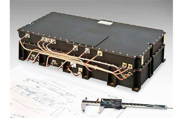
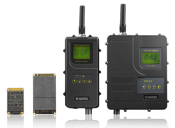
Finnish radio data communication specialist Satel will present innovative new products for mission-critical radio data networks at INTERGEO, being held in Stuttgart, Germany, Sept. 15-17.
In Germany, radio data communication solutions from Satel are distributed by the full-range and systems provider Welotec. At the trade fair in Stuttgart, the partners will present their products at adjacent stands. Both Satel as a radio data communication specialist and Welotec as a full-range and systems provider have a strong portfolio for the core market of RTK/GNSS, UAV and RPAS (remotely piloted aircraft systems) applications.
By 2020, Satel intends to be the world’s number one provider of mission-critical data connections, it said in a statement. This goal also includes becoming the technology leader, which the company hopes to achieve through intensified research and development.
At INTERGEO, Satel will present its latest products. Visitors will be able to see the OEM modules Satelline-M3-TR1 and Satelline-M3-TR4. These modules allow use of the frequencies requiring a license (330 – 473 MHz) as well as the European license-free frequency ranges (433.05 – 434.79 MHz and 869.400 – 869.650 MHz).
The newly developed Satelline-M3-TR4 is the smallest available data transceiver module in its class, according to Satel. The Satel Compact-Proof is a portable radio data modem with a rechargeable battery and a flexible tuning range (403 – 473 MHz). The robust Satelline EASy Pro 25W, likewise with a broad tuning range (403 – 473 MHz), allows radio communication up to a range of 50 km, which makes it quite versatile.
Welotec offers a large range of antennas that supplement the Satel radio data modems. The antennas cover a large frequency range from 68 MHz to 6000 MHz, indoor and outdoor applications, MIMO technology and also antennas with an operating range from minus 40 degrees Celsius to 80 degrees C for use in harsh environments. At INTERGEO, visitors will see innovative solutions from Welotec in the area of industrial communication — for example, the industrial UMTS, LTE and WLAN routers of the TK800 series or the high-performance Industrial-WLAN access point DM500. For measuring tasks, Welotec offers the laser distance sensor OWTB V2.1, which features an extremely high resolution and ranges of up to 500 meters for industrial applications.
Satel and Welotec will be at INTERGEO 2015 in Stuttgart in Hall 4, Booth G4.020. GPS World is covering INTERGEO live — visit gpsworld.com and follow us on Twitter and Facebook.
The newest version of MicroSurvey FieldGenius delivers expanded toolsets and enhanced capabilities for fast, accurate and complete field data collection, according to maker MicroSurvey Software. FieldGenius 8 was developed through close market collaboration and feedback from users, and provides tight control over crucial aspects of field data collection through expanded toolsets and an enhanced user experience, the company said.
Benefits of the new release include:
Easy GNSS Local Transformation. A redesigned interface provides a streamlined workflow along with the ability to export/import localization files and use Helmert transformation.
Enhanced DXF Support. Blocks, extrusion vectors, circles, and other entities are now supported in DXF file format for faster and easier drawing import.
Advanced Point Averaging. The routine allows users to take multiple GNSS and/or TPS temporary measurements of a point and calculate an averaged position for increased accuracy and reliability.
All-New Electronic Bubble. Integrated inertial sensors are now supported, which enables tilt compensated surveying on selected receivers and improves efficiency at difficult job sites.
Native Unicode Support. Unicode character encoding has been implemented throughout the program. International users can now use their own language for data entry inside FieldGenius.
Simplified GIS Mapping. GIS attributes can now be easily added to figures. In addition, users can quickly access default/previous values for both points and figures to make mapping tasks even easier.
FieldGenius 8 also includes improvements to road alignments, an onboard basic measurement mode, dynamic screen rotation, and expanded ASCII export options. Additionally, supported coordinate systems, geoids, instruments, and data collectors has been expanded, making it easier to integrate into existing survey operations.
The four MMS spacecraft host the highest ever operational GPS receivers in space. (artist’s rendition, credit: NASA)
Editor’s Note: See additional coverage of the MMS mission here.
September Marks Start of Magnetosphere Mission, but Navigators Already Perform
A NASA mission to explore magnetic reconnection also made GPS history this spring. The Magnetospheric Multiscale (MMS) mission, led by NASA’s Goddard Space Flight Center in Greenbelt, Md., is flying four identically equipped spacecraft in a tight formation to take measurements 100 times faster than any previous space mission.
Each of the four spinning MMS spacecraft — roughly the size of a ballpark once eight booms deploy — is equipped with 25 sensors and other components provided by more than 40 partner institutions in the U.S., Europe and Japan. One key component is a GPS receiver dubbed Navigator.
Magnetic reconnection is a fundamental, yet poorly understood process.While reconnection occurs throughout the universe when magnetic field lines within plasma connect and disconnect, it can impact our technological society, since it drives virtually all space weather events that can disrupt low-Earth-orbiting spacecraft and lead to GPS, communications and power blackouts on Earth.
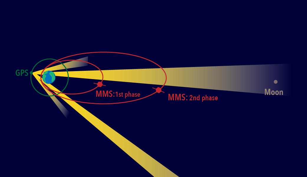
During the mission’s first phase, which begins in September, the spacecraft will travel through reconnection sites on the sun-side of Earth, where the orbit extends out toward the sun to around 47,500 miles. One year later, ground controllers will move the spacecraft to Earth’s night-side or magnetotail where the magnetic fields also reconnect — an orbit that extends away from Earth to almost 99,000 miles, nearly halfway to the moon.
However, science operations can’t begin before the four move into a highly elliptical orbit and assume their pyramid-shape formation that places the spinning spacecraft just 6.2 miles apart. It required a breakthrough to accomplish such an exacting formation, and the Goddard-developed Navigator GPS provided the solution.
Begun in the early 2000s as an enabling technology for MMS-type missions, the Navigator receiver and associated algorithms can quickly acquire and track GPS radiowaves even in weak-signal areas well above GPS’s 30-plus-satellite constellation positioned about 12,550 miles above Earth. In addition to continuously tracking weak signals, the Navigator also must operate as the spacecraft spin at three revolutions per minute. As a result, each MMS satellite is equipped with two Navigator receivers (primary and redundant), with four antennas placed around the perimeter of each, assuring continuous contact with the tracked GPS satellites
“Spinning adds a whole new dimension to trying to figure out where you are,” said Ken McCaughey, MMS GPS Navigator Product Development Lead at Goddard. “As the spacecraft rotates we have an algorithm running that allows us to hand off from one antenna to the next without losing the signal.”
Robust Receivers. To the satisfaction of the technology’s architect, Goddard technologist Luke Winternitz, the receivers have proven very robust. Shortly after the GPS receivers were powered on after the launch, Navigator became, at more than 43,500 miles above Earth’s surface, the highest ever operational GPS receiver in space. “We’re tracking up to 12 GPS satellites at maximum altitude and track on average about nine,” Winternitz said. “We’re really excited about their performance so far.”
Even if the receiver were to lose all GPS signals for part of the orbit, Navigator is specifically designed to handle such dropouts. By gathering as many observations as possible, integrated software called GEONS — Goddard Enhanced Onboard Navigation System — can still compute the orbit by incorporating additional information including drag force, gravity, and solar radiation pressure.
The red ellipses show the MMS orbit paths during the first and second phases of the mission. Each spacecraft uses GPS signals — which come from satellites situated along the green circle shown surrounding Earth — from the far side of Earth to track its position. (Credit: NASA/MMS)
This system will be even more important during the second phase of the MMS mission when the orbit will double in size and travel all the way out to 95,000 miles from Earth.
“It’s going to be very interesting to see how far out MMS can still receive signals,” said Mission Deputy Project Manager Brent Robertson. “But Navigator has already far exceeded expectations.”
Almost all activities associated with operating the mission depend on where the satellites will be positioned a few days hence. That includes everything from determining the best time to downlink telemetry and scientific data to calculating when ground controllers would command the firing of the satellites’ onboard thrusters, which move and help maintain their orbital formation — an exercise that will happen at least once every couple weeks.
“I think there’s a good chance we’ll end up being able to use GPS and save us some of the expense of using ground observations,” Robertson said.
While Navigator technology and GPS receivers were previously flown for testing and to help navigate a low-earth-orbit mission, this is the first time that the complete Navigator package has been used to actively navigate a high-altitude mission. Now that the team knows it works so well, Navigator can be used for other missions that travel in similar high orbits.
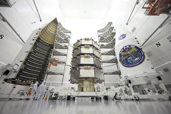
The four MMS observatories are processed for launch in a clean room at the Astrotech Space Operations facility in Titusville, Fla. The MMS mission launched March 12, 2015. (Credit: Ben Smegelsky/NASA)
Navigator Highlights
At the highest point of the MMS orbit, at more than 43,500 mile above the surface of the earth, Navigator set a record for the highest ever reception of signals and onboard navigation solutions by an operational GPS receiver in space.
At the lowest point of the MMS orbit, Navigator set a record as the fastest operational GPS receiver in space, at velocities over 22,000 miles per hour.
At the farthest point in its orbit, some 43,500 miles away from Earth, Navigator can determine the position of each spacecraft with an uncertainty of better than 50 feet.
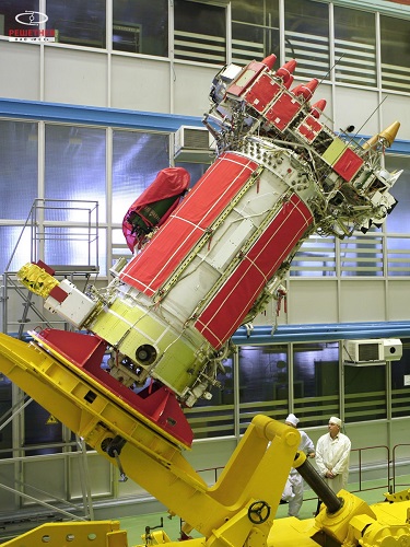
The last of the GLONASS-M satellites (serial number 61) has been built and has passed all acceptance tests, reports the July 20 issue of Sibirskii Sputnik (Siberian Satellite), the internal newspaper of ISS Reshetnev. It will join eight other GLONASS-M satellites in storage on the ground awaiting launch between now and 2017.
Following the launch of the last GLONASS-M satellite, 11 GLONASS-K1 satellites will be launched through 2020. The GLONASS-K2 model is currently under development and will be launched beginning in 2017, according to a presentation made by ISS Reshetnev at the Workshop on the Applications of Global Navigation Satellite Systems held in Krasnoyarsk in May 2015.
A metal object that may be a large piece of a Galileo rocket has been found on a Florida beach. The object appeared to bear the markings of the European Union’s Galileo satellite program, reports the SunSentinel.
It was discovered Sunday behind the oceanfront Sun Tower Hotel & Suites in Fort Lauderdale.
The mattress-sized fragment attracted onlookers until late Sunday morning when it was tractored off the beach by a city cleanup crew and handed over to police. Police hauled the debris away and planned to hold it for inspection by Federal Aviation Administration officials on Monday, according to police Capt. Frank Sousa.
Several rockets have been launched from the French and European spaceport near Kourou in French Guiana, on the northeast coast of South America. The EU’s Galileo satellite navigation system now has eight satellites in orbit following the launch of the latest pair in March. How the debris ended up on the Fort Lauderdale beach is under investigation.
In a late June filing with the Federal Communications Commission (FCC), Lightsquared asked the agency to reassign its spectrum licenses — which were at the root of a prolonged dispute in 2010 and 2011, and have never been fully utilized — to a new licensee that would be wholly owned by a new company, New LightSquared. This is part of LightSquared’s efforts to re-emerge from bankruptcy.
LightSquared wants to resume its own interference testing scheme, floated in 2011 after an independent, collaborative effort found ample LightSquared interference with GPS. The company has contracted with Roberson and Associates, a technology consulting firm, to develop its interference study.
LightSquared is being represented before the FCC by Reed Hundt, a former FCC chairman who served from 1993 to 1997.
LightSquared listed 28 different GPS receivers and related devices that it wants to test for interference with its terrestrial mobile broadband service. The devices include certified and non-certified aviation receivers and avionics equipment, general location, cell phones and 13 different high-precision clocks and receivers.
Hundt specificaly identifed three companies — Trimble, Garmin, and John Deere — that he wants to come forward and provide proprietary technical and business information “in confidence” to tester Roberson. In statements to the FCC, Hundt twice used the phrase “speak now or forever hold your peace.”
In March of this year, LightSquared obtained U.S. court permission to exit bankruptcy protection, which it entered in 2012. At that time, the FCC had concluded, after lengthy testing, hearings, charges and countercharges, that the wireless broadband service proposed by LightSquared would interfere with GPS signals and associated positioning, navigation, and timing.
New LightSquared reportedly has $1.25 billion in operating funds to help “make full use of its spectrum to provide existing and innovative services.”
In a recent trial involving the assets of the bankrupt company, the value of its spectrum bands was estimated at possibly $4.5 billion or higher.
GPS Industry Response. The GPS Innovation Alliance responded in early July to media reports on LightSquared’s position regarding the testing of the compatibility of terrestrial broadband and GPS.
Following is the GPS Innovation Alliance’s response:
“The GPS Innovation Alliance (GPSIA) supports a consensus-driven process, including all government and non-government stakeholders, to clearly identify and address remaining technical issues raised by LightSquared proposals to repurpose mobile satellite spectrum for terrestrial broadband use.
“The technical challenges posed by these proposals are formidable, as evidenced by the conclusions of multiple U.S. government entities. Specifically, the U.S. Departments of Defense and Transportation and the NTIA have all found in the last several years that LightSquared’s proposals have significant potential to interfere with GPS.
“Contrary to LightSquared’s recent suggestions, this is not simply a private matter between three GPS companies and LightSquared, but is important to all GPS users who rely on this critical technology every day. The Department of Transportation has sponsored an ongoing effort to assess adjacent band issues, and the GPS industry is actively engaged with the Federal Communications Commission (FCC), Department of Transportation (DOT) and other government stakeholders to drive consensus around next steps.
“While we welcome the participation of LightSquared consultants, any further analysis of the technical issues should be informed by input from all of the relevant stakeholders, rather than the one-off efforts of an interested party.”
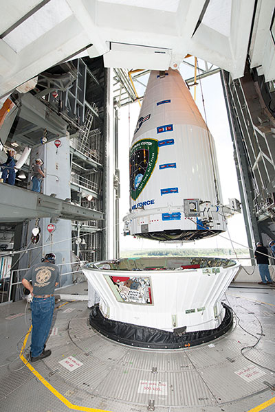
Tenth GPS Block II Follow-On Satellite Rises Above
This one’s in orbit now. Photo shows the nose cone containing GPS IIF-10 being lowered into position atop the launch vehicle, inside the rocket gantry at Cape Canaveral.
The tenth GPS IIF satellite lifted off from the Space Launch Complex (SLC)-41 at Cape Canaveral, Fla., on schedule at 11:36 local time (15:36 UTC) — at the start of a nineteen-minute window.
Later that same day, United Launch Alliance (ULA) officials declared the launch mission a success. The Centaur upper stage completed its second burn and released the GPS IIF-10 satellite into the navigation network to complete the launch of the Atlas 5 rocket.
This is the second of three GPS constellation replenishment flights planned in 2015. The first launch, of GPS IIF-9 using a Delta IV rocket, occurred on March 25. A third launch, of GPS IIF-11 using an Atlas rocket, is scheduled for Sept. 22. The launch of GPS IIF-12 is scheduled for Jan. 26, 2016.
The Boeing-built GPS IIF-10 is one of the next-generation GPS satellites, incorporating various improvements to provide greater accuracy, increased signals, and enhanced performance for users. GPS IIF-10 was the 70th spacecraft to be launched as part of the GPS constellation and the tenth in the Block IIF series that began launching in May 2010.
GPS IIF-10 marks the 55th Atlas V launch since the vehicle’s inaugural launch in 2002 and the 27th flight of the 401 configuration. Every operational GPS mission has launched on a United Launch Alliance or heritage rocket. While the government has certified ULA competitor SpaceX for GPS III launches, a SpaceX Falcon 9 rocket exploded June 29, two minutes after launch of an International Space Station resupply mission.
The Boeing-built GPS IIF satellites provide improved signals to support both the warfighter and the growing civilian needs of the global economy, the U.S. Air Force said in a statement. The GPS IIF satellites will provide improved accuracy through advanced atomic clocks, a longer design life than previous GPS satellites, and a new operational third civil signal (L5) that benefits commercial aviation and safety-of-life applications. It will also continue to deploy the modernized capabilities that began with the GPS IIR satellites, including a more robust military signal.
Raytheon has installed the first operational hardware for the GPS Next Generation Operational Control System, known as GPS OCX. The new ground command and control system will significantly modernize U.S. GPS capabilities and manage the next generation of GPS satellites. Installation of the Launch and Checkout System (LCS) hardware was completed in early July at Schriever Air Force Base in Colorado, the eventual home for the new GPS OCX Master Control Station.
“Installation of the initial OCX hardware at Schriever AFB represents a key milestone for the program, demonstrating further progress toward next year’s acceptance of the OCX Launch and Checkout System for the GPS III satellites,” said Matt Gilligan, vice president of Navigation and Environmental Solutions at Raytheon Intelligence, Information and Services. “Raytheon is committed to delivering a modernized, secure GPS ground system to support the millions of U.S. military, civil and commercial users of GPS worldwide,” added Gilligan.
GPS OCX will deliver a host of new capabilities, including automation for operational efficiencies, improved accuracy, interoperability with geo-positioning and navigation systems of other nations for better global coverage, and a cybersecurity architecture that provides unprecedented levels of protection. The Launch and Checkout System delivers a large subset of the full OCX ground system capabilities, and establishes the OCX cyber-hardened infrastructure for additional mission applications that will be added to complete the Block 1 capability.
U.S. warfighters use GPS services to support air, land, sea and space missions. GPS is also used by millions of people to enhance daily life activities, including personal navigation. It’s also required for industry and businesses and is essential to support safety-of-life missions for air traffic controllers and emergency responders. The modernized ground system will bring new capabilities and precision to the GPS enterprise.
Two BeiDou navigation satellites were launched into medium Earth orbit on Saturday, July 25, at 12:29:04.411 UTC, according to a NASASpaceFlight.com Forum blog. The satellites are drifting to their designated orbits. U.S. Joint Space Operations Center / NORAD is tracking the satellites.
The satellites are designated BDS M1-S and M2-S — the “S” in the satellite names might stand for “Test” (in Chinese: 试验 = Shiyan).