Veripos, a supplier of high-precision GNSS positioning facilities to offshore and associated industries, has upgraded its Apex and Apex² precise point positioning (PPP) services.
The services now typically provide users with a horizontal position accuracy of better than 5 cm and 12 cm in the vertical at the two sigma (95 percent) confidence level.
The enhanced levels of performance, now available to all current users of Apex and Apex² without any need to upgrade, have been calculated from static data obtained in Aberdeen, Scotland, where Veripos is headquartered, as well as Houston, Texas, and Singapore. Veripos said that accuracies may vary with observing conditions, however.
The improved accuracy follows a major upgrade of the entire Veripos global reference station network for tracking all GNSS signals, together with introduction of new receivers and geodetic antennas for delivery of better measurement quality resulting from refinements to algorithms and software used to derive necessary GNSS orbit and clock corrections.
Designed to meet all offshore positioning and navigation applications, the dual-beam Apex and Apex² PPP services are relayed via seven geostationary communications satellites to ensure continuous availability and service redundancy while providing access to both GPS and GLONASS constellations. Positional accuracy is maintained regardless of user location, Veripos said.
Two more full operational capability (FOC) Galileo satellites are scheduled for launch March 27. This video shows the four first-stage boosters of the Soyuz launcher being assembled in Europe’s Spaceport in French Guiana. Assembly takes place on a horizontal basis, in the Russian manner. The video shows four thrusters assembled around the main body. After takeoff, the engines burn for 120 seconds and then are dropped. The thrust is transferred to the main body by a ball joint located above the propeller of the cone-shaped structure.
The launch of the fourth satellite for the Indian Regional Navigation Satellite System, previously scheduled for March 9, has been postponed until March 29 at 13:00 UTC. The delay is due to the replacement of a faulty telemetry transmitter on the satellite.
“We are targeting the last few days of March for the launch. A team is working on a new telemetry transmitter to replace the [faulty] one that failed in the satellite. After fixing it, all numerous tests that we conducted earlier must be repeated,” M.Y.S. Prasad, Director of the launch unit, Satish Dhawan Space Centre, Sriharikota, told The Hindu on Tuesday.
The launch, originally scheduled for March 9, was delayed March 4 when routine checks found a transmitter malfunctioning. The ISRO delayed the flight and removed the satellite from its launcher to put a new transmitter.
IRNSS-1D will be fourth in the seven-spacecraft IRNSS constellation.
— With information provided by the CANSPACE listserv.
Galileo satellite being prepared for fit check. This testing, to ensure the seventh and eight Galileo satellites fit onto their dual-launch dispenser took place in mid-February 2015. The dispenser sits atop the Fregat upper stage of their Soyuz ST-B launcher. Photo: European Space Agency
By the European Space Agency
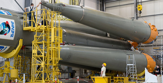
All the elements for this month’s Galileo launch are coming together at Europe’s Spaceport in French Guiana. As the two satellites undergo final testing and preparations, the first part of their Soyuz launcher has also been integrated.
Assembly of the Soyuz ST-B’s first two stages, plus its four first stage boosters, took place at the Spaceport’s Soyuz Launcher Integration Building last week. Assembly takes place on a horizontal basis, in the Russian manner.
The next step will be the addition of the third stage, then the main part of the launcher will be complete, ready to be transported to the Soyuz launch pad and moved to the vertical position.
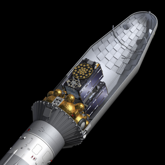
The final fourth stage of the Soyuz is the reignitable Fregat, which will transport the two satellites to their final 23,222-km altitude medium Earth orbit. This will be attached to the Soyuz on the launch pad, once the satellites, their dispenser and launch fairing have been mounted on it.
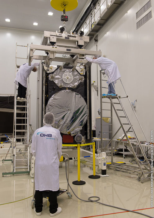
Since the seventh and eighth Galileo satellites arrived in French Guiana last month, they have undergone several tests – including one System Compatibility Test Campaign each, where they are linked up to the rest of the global Galileo ground segment as if they are already ‘live’ in orbit.
Assembly of seventh and eighth Galileo satellites’ Soyuz ST-B’s first two stages, plus its four first stage boosters, took place at the Spaceport’s Soyuz Launcher Integration Building in the first week of March 2015. Assembly takes place on a horizontal basis, in the Russian manner. Photo: European Space Agency
The all-important ‘fit check’ was passed in the middle of February. The two satellites were installed separately onto their dual-launch dispenser, to check they fitted correctly.
This dispenser has the task of holding them in place atop the Fregat during the launch and flight to their final orbit, then releasing them. They will be installed together later this month, after the satellites have been fueled.
Last week saw the finalization of their hardware and software, and the charging of their batteries — on which the satellites will be reliant from the short but crucial period from their launch to the unfurling of their solar arrays in orbit.
The pair of satellites is now ready to be transferred to the Spaceport’s S5A fueling facility, where they will receive the fuel to keep them controllable during their 12-year working lives.
After their fueling and final check, the pair of satellites will be in launch configuration. After a final review they will then become available for Arianespace teams to carry out the final preparation, known as Combined Operations, leading to the launch day.
The launch of the seventh and eighth Galileo satellites will take place on Friday, March 27.
Cutaway view of the Soyuz rocket fairing carrying a pair of Galileo satellites. Photo: European Space Agency
The Soyuz launcher for Arianespace’s upcoming mission with two European Galileo navigation satellites is taking shape at the Spaceport for a March 27 liftoff from French Guiana.
“During activity in the Spaceport’s Soyuz Launcher Integration Building, the medium-lift workhorse began to assume its iconic form with integration of the four first-stage strap-on boosters to the Block A core second stage,” Arianespace wrote in an statement.
“The next step will be the mating of Soyuz’ Block I third stage to the launcher’s core, completing the basic build-up, and readying the vehicle for its rollout to the launch pad — where the payload will be mated.”
The March 27 flight will be the 11th Soyuz flight from French Guiana since the launcher’s introduction at the Spaceport in October 2011. It is designated Flight VS11 in Arianespace’s numbering system for its launcher family, which also includes the heavy-lift Soyuz and lightweight Vega.
For the upcoming Soyuz mission, Arianespace will loft Galileo’s third and fourth Galileo Full Operational Capability (FOC) satellites to further expand the constellation. Flight VS11’s two satellites were built by OHB System, with Surrey Satellite Technology Ltd. supplying their navigation payloads.
Galileo’s complete operational network and its ground infrastructure will be deployed during the program’s Full Operational Capability phase, which is managed and funded by the European Commission. The European Space Agency has been delegated as the design and procurement agent on the Commission’s behalf.
Rohde & Schwarz adds ERA GLONASS to its reliable test solution for in vehicle emergency call systems. Photo: Rohde & Schwarz
Effective January 1, 2015, all new car models introduced to the Russian market must be equipped with the automatic ERA-GLONASS emergency call system. Rohde & Schwarz now offers a standard compliant test solution for manufacturers and suppliers of these in-vehicle systems.
Rohde & Schwarz is demonstrating its ERA-GLONASS test setup at Mobile World Congress, being held this week in Barcelona, Spain.
The test setup consists of the R&S CMW500 wideband radio communication tester and R&S SMBV100A vector signal generator as a GNSS simulator. This setup allows manufacturers and suppliers of automatic in-vehicle systems (IVS) to perform reliable and reproducible pre-conformance tests on their ERA-GLONASS modules in the lab.
In the Russian Federation, ERA-GLONASS works much like the European Union’s eCall system. When an accident occurs, the IVS connects with a public safety answering point (PSAP) via the local wireless communications network and transmits a standardized minimum set of data (MSD). In addition to GLONASS or GPS coordinates, the MSD also contains data with information about the accident vehicle as specified in ERA-GLONASS. If no voice connection can be made or if data cannot be transferred via the voice channel, the MSD is sent to the PSAP via SMS. This fallback option is a special ERA-GLONASS feature. The Russian system is also certified for 2G and WCDMA networks.
Rohde & Schwarz developed its R&S CMW-KA095 application software to meet ERA-GLONASS requirements in line with Russia’s GOST specification. Based on the R&S CMW-KA094 eCall software, the R&S CMW-KA095 simulates a PSAP and controls the R&S CMW500 emulating a wireless communications network in the lab. The software also controls the GNSS simulator that supplies the coordinates required for vehicle localization. With this solution, users can verify whether their IVS modem is able to successfully initiate an emergency call, transmit the correct MSD and establish a voice connection with a PSAP. The results are interpreted in line with the GOST specification.
The ERA-GLONASS SMS protocol has also been integrated into the test solution, making it possible to test the SMS functionality of the IVS modem when no voice connection is available.
The test solution is fully automated because of the R&S CMWrun sequencer software. The R&S CMW-KT110 eCall/ERA-GLONASS test package provides a user-friendly, automated functional test in line with GOST55330, enabling users to verify the operability of an entire system in the lab and document it in a report.
Editor’s Note: Alan Cameron is editor-in-chief and publisher of GPS World magazine. He also writes the monthly GNSS Design & Test newsletter. The views expressed are his own.
“It’s tough to make predictions, especially about the future.” This insight comes from the 20th-century American sage Yogi Berra. Yet predictions — hedged guesses, if you will — form the basis of nearly all new business ventures and decisions in ongoing business activities.
For surveyors in the year 2015, one of the key predictions — or guesses — to make concerns the next GNSS to come predictably and reliably online, to augment GPS where GPS alone does not fully function: under canopy, in dense urban environments, and so on. More satellites visible at more varied angles in the sky can help surmount these obstructions.
Staking the future of one’s business, in the form of new equipment acquisition, in such an environment is a bit like betting on a long-distance horse race. First one steed surges to the head of the pack, then it falls back as another charges forward. We have seen this pattern repeatedly in the growth of GLONASS, Galileo and BeiDou.
Some may say that GLONASS, the Russian system, has already won the race (the first heat, at least) and currently fills the role of GPS partner in precision surveying. It does, to some extent, but its future viability is cloudy — and its past record is patchy, to say the least. It rose to full operational capability around the turn of the century, then fell very, very low in numbers as short-lived satellites expired and were not replaced at sufficient rate. Recently, GLONASS has mounted a resurgence, but that has been marred by repeated launch failures and a disturbing anomaly. It cannot be counted or confirmed a winner, yet.
I spoke yesterday with an expert and veteran professional land surveyor who expressed the opinion that the manner in which surveying is conducted will change more in the next five years than it has in the last 25. Keep in mind that the last 25 years saw enormous changes themselves, as GPS significantly transformed, upgraded and made vastly more efficient most surveying activities.
Betting on a horse race in such a rapidly changing environment becomes even more chancy.
Here’s a tip from a racetrack tout: don’t count Galileo out.
GLONASS we recounted briefly above. BeiDou recently achieved a regional operations status over Eastern Asia, but further developments there have been puzzlingly quiet for some time.
The European system has come on with agonizing slowness since the year 2000, suffering many delays and most recently what could have been a debilitating failed dual launch. But the combined strength of the European Union continues to push determinedly forward, and the program has an ambitious schedule with an eye firmly fixed on operability. And some recent research results tend — perhaps — to substantiate the claim, long pooh-poohed by those in the United States, at least, that Galileo will eventually prove “better” than GPS. Details further on.
What might a prudent yet pragmatic, forward-looking surveying firm do in this uncertain environment, where the only certainty is change, and likely to be rapid change at that? Here’s another racetrack tip: don’t make any big bets just yet, but study the field closely and continuously. In particular, watch Galileo’s performance.
A further item to be checked in Galileo’s favor: its system operators have long been in close talks with the U.S. government on many matters involving co-operation and interoperability. As recounted in a recent story concerning the Federal Communications Commission’s surprising role in this matter, the Europeans are filling out the proper forms for full accreditation within the United States. This could turn out to be important in business operations.
Back to studying the field closely: also study leading manufacturers’ offerings in this regard. They also are making bets on the future; quite possibly they have better information, and/or have done more extensive analysis of what information is available, paired with in-depth, highly technical research and development of signal characteristics and how signals from disparate GNSS can be most productively combined.
A quick scan of GPS World’s2015 GNSS Receiver Survey shows the following key manufacturers (among others) have GPS receivers now commercially available that are Galileo-ready: Altus Positioning Systems, Ashtech, Geneq, iFEN, JAVAD GNSS, Leica Geosystems, NovAtel, NVS Technologies, Septentrio, Sprecta Precision, Spectrum, Topcon, and Trimble.
Better than GPS???
Supporters of Galileo have long raised hackles west of the Atlantic with claims that Galileo would provide better accuracy than GPS. Not! cried the faithful, and especially not when the modernized and improved, strengthened, more accurate GPS III signals are coming along just as fast if not faster than Galileo. Recently the pace of GPS III has come into question; can the Gold Standard and clear leader for 25+ years really be falling back into the pack?
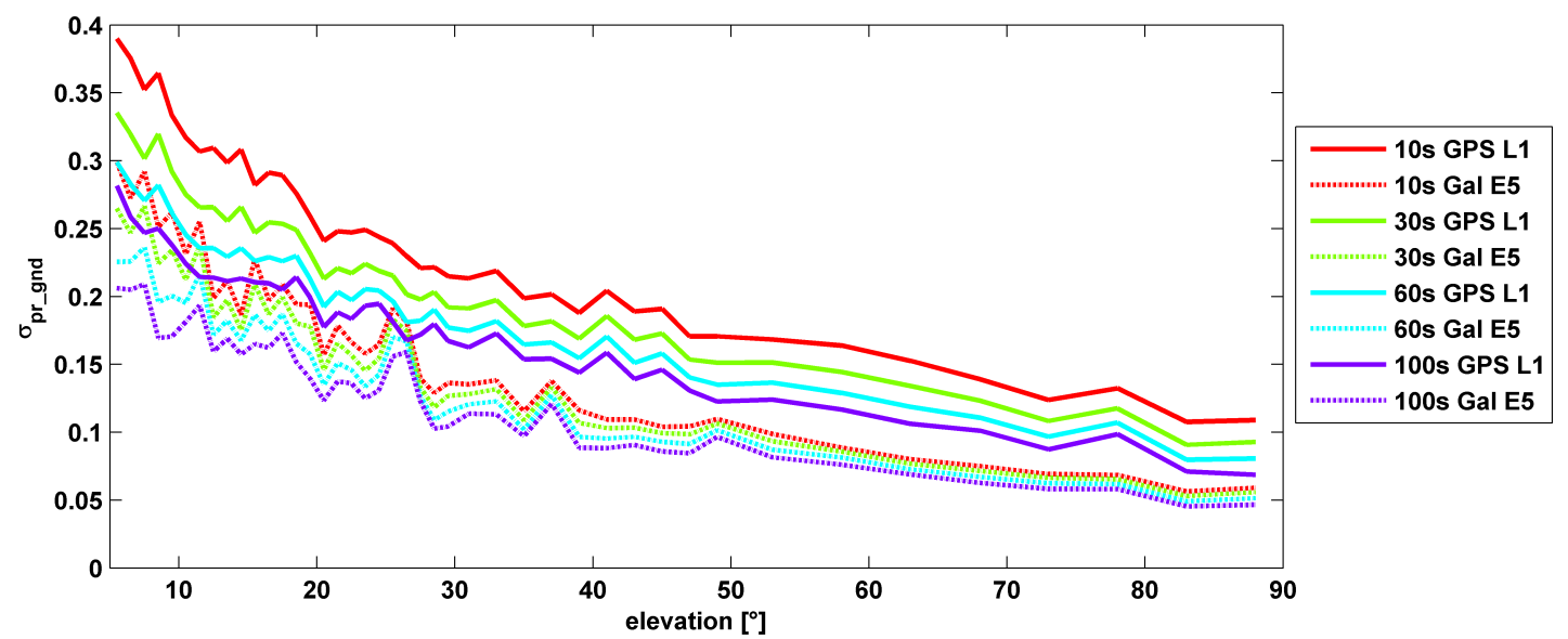
σ(pr_gnd) versus elevation for Galileo E1 (dotted lines) and GPS L1 (solid lines for different smoothing constants: red (10s), green (30s), cyan (60s), purple (100s).
Let’s disregard that question for the time being, and look at some recent research, to be reported in full in the cover story of GPS World magazine’s April issue, out soon. In it, the authors (two German and one American researcher) report:
“Analysis of new Galileo signals at an experimental ground-based augmentation system (GBAS) compares noise and multipath in their performance to GPS L1 and L5. Raw noise and multipath level of the Galileo signals is shown to be smaller than those of GPS. Even after smoothing, Galileo signals perform somewhat better than GPS and are less sensitive to the smoothing time constant.”
This is all pretty arcane and a bit removed from current field of operations, as far as surveyors are concerned. But it does signal something, and it provides food for thought.
The researchers obtained their results using four JAVAD Delta receivers, all connected to Leica AR 25 choke ring antennas.
GIS software provider Supergeo will release an NTRIP solution on SuperPad, its Windows Mobile GIS app, for high-accuracy field data collection and geospatial workflow enhancement.
SuperPad is a feature-rich mobile GIS application for field-based personnel to collect, edit, display and measure spatial data. The flexible development environment and customized extensions enable users to create a custom platform. SuperPad supports synchronizing data with an enterprise’s server to improve efficiency.
SuperPad version 3.3 will support an NTRIP solution with RTK technology. Real-time kinematic (RTK) satellite navigation, one of the latest and widely used technologies within the field of differential GNSS, significantly enhances the precision of the positioning data. RTK positioning can raise accuracy to the centimeter-level.
With the NTRIP solution, SuperPad is not only be capable of handling post-process DGNSS workflow, but also allows users to connect to network RTK service providers with NTRIP protocol, such as a virtual reference station RTK service provider or private station services. Its operations for turning on the module and quick-to-use settings will save surveyors time, while supporting GNSS receivers from makers such as u-blox, Hemisphere GNSS and NovAtel.
Progress of the SuperPad NTRIP Extension is also visualized as a condition monitoring informer on the map intuitively. Users looking for high accuracy or precision status with the RTK correction will find more details about the fixing mode and GNSS information presented clearly with the renewed GPS Status pages.
During the integrated electrical checks on March 3 of the launch vehicle and satellite following closure of the heat shield, an anomaly was observed in one of the telemetry transmitters of the satellite, according to a post on the Indian Space Research Organization (ISRO)’s Facebook page.
“In order to resolve the technical anomaly through further test, simulation and analysis, the launch of PSLV-C27 with IRNSS-1D has been postponed,” the post states. IRNSS-1D will be flown into space in the Indian Polar Satellite Launch Vehicle-XL (PSLV-C27) from Satish Dhawan Space Centre, Sriharikota.
IRNSS-1D is the fourth navigation satellite in the Indian Regional Navigational Satellite System, and will make the constellation operable.
Trimble, together with its distribution partner Ultimate Positioning Group (UPG), announced the availability of Trimble VRS Now correction service in Queensland, New South Wales, South Australia, Tasmania and Victoria.
Trimble is also now offering the Trimble VRS Now correction service in Oregon’s Willamette Valley.
The commercial subscription service provides surveyors, civil engineers, geospatial professionals and other industry specialists in these areas with instant access to real-time kinematic (RTK) GNSS corrections without the need for a base station.
Using both GPS and GLONASS constellations, the Trimble service delivers centimeter-level RTK corrections customized for each GNSS receiver’s location anywhere in the network via cellular communications. The Trimble VRS Now service supplies accurate, reliable and easy-to-use GNSS positioning for a variety of applications including surveying, urban planning, urban and rural construction, environmental monitoring, resource and territory management, disaster prevention and relief and scientific research, Trimble said.
“The addition of VRS Now to Trimble’s current portfolio of corrections technologies and services in Australia highlights our ability to meet any accuracy, delivery, availability and financial consideration across a variety of applications and markets,” said John Sprivulis, business area director of Trimble’s Positioning Services Division in the Asia Pacific. “Trimble is effectively creating a national positioning infrastructure to meet Australia’s future needs.”
Trimble VRS Now in Australia is a continuation of Trimble’s focus on providing solutions that enable customers to increase productivity by simplifying access to high-precision accuracy around the world. Similar VRS Now services are operating in parts of the U.S. and Europe.
In addition, the Australian VRS Now service supports the Trimble Pivot Field Mobile App, which provides up-to-the-minute information on the VRS Now system status for users in the region.
Because OmniSTAR CORS service in the area is being phased out, existing Australian users will be automatically transitioned to the Trimble VRS Now service, which provides easy access to high accuracy and reliable positioning within the network coverage area.
Service in Australia and Oregon is a continuation of Trimble’s focus on providing solutions that enable customers to increase productivity by simplifying access to high-precision positioning around the world. Similar VRS Now services are operating in Illinois, Indiana, Iowa, Nebraska, Colorado, Florida, Alabama, Mississippi, Texas, and parts of Europe.
During preparation of playback scenarios for the upcoming leap-second event taking place in June, engineers at Racelogic identified a potential pitfall for GNSS engineers. The difficulty arises from the fact that BeiDou uses a different “day number” for the date to apply the leap second, compared with GPS and Galileo. GPS and Galileo use 1-7 as week day numbers, and BeiDou uses 0-6.
If this fact has been missed during development, then the result is that the leap second may be implemented a day early on GNSS engines that are tracking the BeiDou constellation, said Mark Sampson, product manager for Racelogic.
“We tested four different Beidou enabled receivers, from four leading GNSS companies, and none of them appeared to handle the Beidou leap second correctly. This included an engine which originates from China!” Sampson said. “We have since been in contact with two of these companies, who have confirmed that their hardware does have a bug in the leap-second code due to the numbering of the days.”
The error presents itself when the receiver is running on the BeiDou constellation alone, and when the date is June 29 of this year. In some cases, the BeiDou leap second will be adjusted from 2 to 3 seconds from midnight on June 29, which should in fact occur on midnight of June 30. This will result in an error for the reported UTC time of 1 second for the period of this day. In other cases, the leap second was not implemented at all when running on BeiDou alone.
“We have also checked the output of a BeiDou signal generator from a different simulator company, and this too uses the 1-7 range for the BeiDou leap-second date instead of the correct 0-6 range,” Sampson said. “This may explain why a number of commercial receivers appear to have been caught out by this issue.”
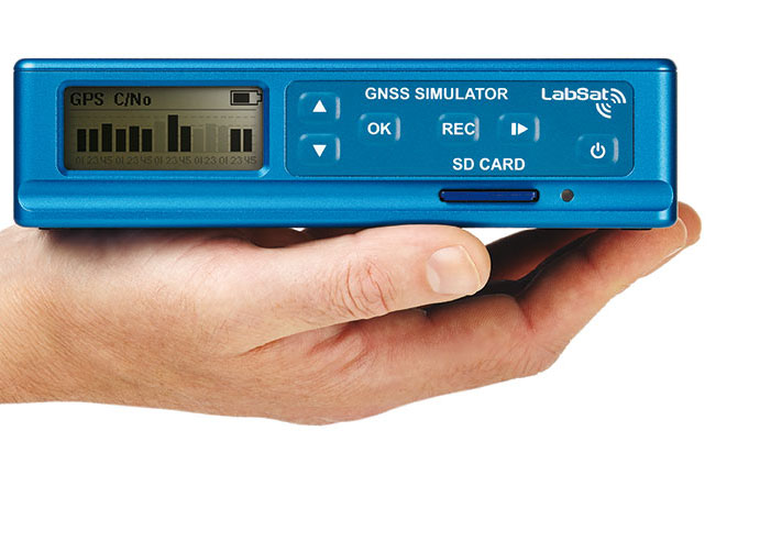
Racelogic LabSat3 simulator.
In order to help companies test for this problem, Racelogic has generated simulated RF data for June 29 and 30, starting 15 minutes before midnight. “We have two sets of files. One set contains BeiDou only signals and the other contains a combination of BeiDou and GPS signals,” Sampson said. “Note that on some of the receivers we have tested, when GPS is being tracked as well, the GPS leap-second message overrides the one coming from BeiDou and applies the leap second correctly.”
The scenarios are compatible with Racelogic’s LabSat3 triple constellation simulator, which is available on a free 15-day loan or can be purchased from Racelogic.