Category: GNSS

  • PlanetiQ Plans GNSS Weather Constellation

    PlanetiQ Plans GNSS Weather Constellation

    Figure credit: PlanetiQ.
    Figure credit: PlanetiQ.

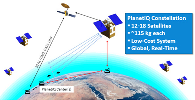
    The company PlanetiQ plans to use GNSS to make real-time weather forecasts. PlanetiQ plans to launch a commercial weather satellite constellation by 2017, composed of 12 to 18 small satellites that will capture data as GNSS satellites pass through Earth’s orbital horizon.

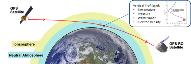
    The satellites will use radio occultation to collect data that will supplement computer models on weather, producing more accurate and timely weather forecasts and assessments, PlanetiQ said. The satellites will measure how GPS, GLONASS, and BeiDou radio waves bend as they travel through the atmosphere, a technique that provides snapshots of temperature, pressure and water vapor, as well as insight into whether solar storms are active in the ionosphere, reports Discovery News.

    Figure credit: PlanetiQ.
    Figure credit: PlanetiQ.

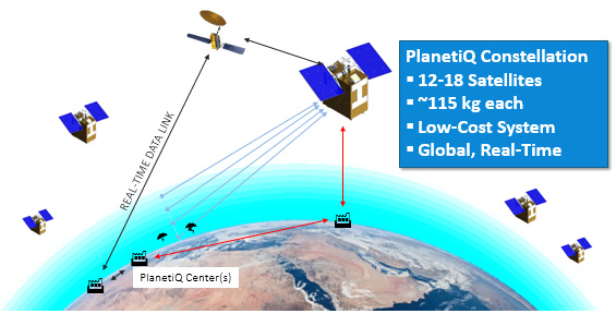
    More than 30,000 occultation measurements can be collected each day.

    PlanetiQ is one of five companies in the United States looking to commercialize weather forecasting. GeoOptics is working on a similar system and plans to launch its first satellite this year.

    Explore further:

    • PlanetiQ President and CEO Anne Hale Miglarese discussed the project on The Weather Channel in August 2014.
    • The March 1994 Innovation column “Monitoring the Earth’s Atmosphere with GPS” discusses the use of radio occultation using GPS satellites.
    • Attila Komjathy, a NASA Jet Propulsion Laboratory principal investigator and adjunct professor in the University of New Brunswick’s Department of Geodesy and Geomatics Engineering, was named a Fellow of the Institute of Navigation in January for his work on remote sensing of the Earth’s ionosphere using signals from GNSS.
  • Russia, China Sign Satellite Navigation Agreement

    012015_china3

    Russia and China have signed a cooperation agreement on satellite navigation, a Russian Space Agency spokesperson told RIA Novosti on Tuesday.

    Roscosmos chief Igor Komarov met with Xu Dazhe, the leader of China’s National Space Administration, on an official visit in Beijing.

    “The first provision to set up a committee and a protocol were signed during the first working session. Igor Komarov and Xu Dazhe discussed issues of bilateral cooperation in the field of electronic components for rocket construction and building rocket engines,” the spokesperson said.

    A Russian-Chinese committee on satellite navigation was established in October 2014 at the meeting between Russia’s Deputy Prime Minister Dmitry Rogozin and his Chinese counterpart, Wang Yang.

    In November, China North Industries Corporation (NORINCO) and the Russian GLONASS nonprofit partnership agreed to establish a joint venture to promote worldwide services based on GLONASS and BeiDou.

    Russia and China also recently completed joint reconnaissance for the placement of GLONASS differential correction and monitoring stations in the Chinese cities of Urumqi and Changchun. Each country is expected to accommodate three such facilities.
  • Raytheon GPS Ground Program Passes Review

    The ground control system (OCX) that Raytheon is developing for the next-generation GPS program has passed a Pentagon review, reports Reuters. The program will be monitored to ensure it stays on track, a senior Air Force official said on Feb. 6 as reported by the news service.

    Major General Roger Teague, director of space programs for the Air Force acquisition chief, said a review by chief arms buyer Frank Kendall went well, but program officials and the contractor got “tough marching orders” to stick to schedule and cost targets.

    Raytheon’s program manager Matt Gilligan said the review provided the company with “clear direction, the best technology, and appropriate resources to…deliver OCX on a schedule that meets GPS enterprise needs.”

    Kendall had ordered the review after an Air Force restructuring that increased the cost of the program by 80 percent to $1.6 billion.

  • Delta Rocket Moves to Launchpad for March GPS Launch

    The Delta 4 rocket that will launch the next GPS satellite has been rolled out to the launch pad, reports Spaceflight Now. The satellite itself, GPS IIF-9, will be attached to the rocket in March. The United Launch Alliance vehicle is scheduled for launch March 25.

    The launch will be the 371st Delta rocket since 1960 and the 29th Delta 4 since 2002. It also marks the 69th GPS satellite launch and the 55th to use a Delta rocket.

  • BeiDou Precision Nav Will Receive GPS, GLONASS, Galileo Signals

    A senior Chinese government space official on Feb. 5 said precision-navigation user receivers in China will be fitted with chipsets receiving satellite signals from BeiDou, GPS, GLONASS, and Galileo, according to Space News. The move could accelerate the trend among navigation chipset and receiver makers to build gear for multi-constellation reception, and at the same time undermine regional measures to promote one system over others.

    Chen Zhi, deputy chief designer of the China Aerospace Science and Industry Corp., said China’s early deployment of satellite navigation receivers for precision agriculture already feature multi-constellation GPS-Beidou receivers.

    The United States and European Union have signed World Trade Organization agreements for their constellations, GPS and Galileo. China and Russia are not part of the agreements.

  • Judge Rules Against LightSquared in Claims Against GPS Firms

    A U.S. judge dismissed the bulk of two lawsuits by LightSquared and equity owner Harbinger Capital Partners, reports Reuters. The suits accused Trimble, Garmin and Deere & Co. of misleading them about interference concerns and hastening the company’s fall into bankruptcy.

    In an opinion issued Feb. 5 in Manhattan federal court, Judge Richard Berman threw out Harbinger’s lawsuit, and denied nine of 11 claims by LightSquared.

    LightSquared has been in bankruptcy since 2012, when the Federal Communications Commission revoked its license to build a planned wireless network over concerns it could interfere with GPS.

    According to Reuters:

    The lawsuits alleged that Deere, Garmin International , Trimble Navigation Ltd, and a GPS industry group led LightSquared to believe the planned network would not pose an interference risk. It wasn’t until LightSquared had pumped $4 billion into the project, the plaintiffs argued, that the GPS industry voiced their concerns.

    Judge Berman dismissed many claims from both plaintiffs, including breach of contract and civil conspiracy, leaving alive only LightSquared’s claims for negligent misrepresentation and constructive fraud.

    Because the judge did not dismiss all claims, LightSquared could still be able to probe the GPS companies’ books and records during discovery.

  • Latest Galileo Satellites Reach Launch Site

    Latest Galileo Satellites Reach Launch Site

    One of two Galileo satellites, safely in its protective container, is unloaded from an Air France Boeing 747 at Cayenne–Félix Eboué Airport in French Guiana.

    News from the European Space Agency

    Another two Galileo satellites have touched down in French Guiana ready to take their place in Europe’s satellite navigation constellation. The pair, safely cocooned inside their air-conditioned containers inside an Air France Boeing 747, landed at Cayenne–Félix Eboué Airport yesterday.

    They were then taken by lorry to be installed in the cleanroom surroundings of Europe’s Spaceport to begin final preparations for launch.

    The seventh and eighth Galileo satellites will be launched together by Soyuz in late March, resuming the interrupted building of the satnav constellation. The previous Soyuz launch saw the satellites released into the wrong orbit.

    Galileo satellite in its protective air-conditioned container, about to be unloaded from the Air France cargo plane.

    The reason for the malfunction has been pinned down to an installation error in the Fregat upper stage that delivers the satellites into their final orbits. A hydrazine fuel line was bracketed next to a liquid helium line, freezing the hydrazine and resulting in Fregat’s faulty orientation.

    Arrival in French Guiana is the final stop in a complex production and test line that snakes back across Europe. The satellites are built by OHB in Bremen, Germany, with their navigation payloads coming from Surrey Satellite Technology Ltd in Guildford, UK, both companies being supplied in turn by subcontractors across much of the continent.

    The complete satellites are then delivered to ESA’s ESTEC technical centre in Noordwijk, the Netherlands, home to Europe’s largest satellite test centre.

    There, a series of tests reproduces every aspect of the space environment, including acoustic noise and thermal vacuum simulations, to ensure their readiness for space.

    Each satellite is also plugged into the entire worldwide Galileo ground network for days on end to check it works as planned.

    Their testing ended with a clean bill of health and they received clearance on Tuesday to travel to French Guiana. Loaded onto lorries on Wednesday, they arrived at Paris Charles de Gaulle Airport later that day, taking off for French Guiana on Thursday.

    These two satellites are planned to be launched during last week of March, following the European Commission’s endorsement of the resumption of Galileo launches.

    The seventh and eighth Galileo satellites were flown on this Air France Boeing 747 from Paris Charles de Gaulle Airport in France to Cayenne–Félix Eboué Airport in French Guiana on Feb. 5


  • CompassData Granted ISO Certification for Quality-Management Systems

    CompassData, a worldwide provider of geospatial data and services, has received ISO 9001:2008 Certification for Quality Management Systems from Orion Registrar Inc.. The ISO 9001:2008 certification is well established in the United States and around the world as a quality-management system tool.

    CompassData completed a rigorous audit in which Orion Registrar reviewed each step in the firm’s quality-management methodologies used during the creation of GPS-surveyed ground control and other geospatial products such as orthorectified imagery, digital elevation models (DEM), sensor calibrations and GIS map products.

    This certification recognizes that CompassData has established a quality-management system that addresses the scope of the company’s core processes: supplying ground-control points and other high-accuracy products, services and content for the geospatial community. Superior ability to capture and satisfy customer requirements was a key element in the demonstration of the quality-management system to the registrar.

    “CompassData has set itself apart by becoming one of the few geospatial survey data providers in the world whose quality-management systems and processes are ISO 9001 certified,” the company said in a statement.

    ISO (International Organization for Standardization), the supplier of the ISO 9000 family of quality and management standards, is a network of national standards institutes from 163 countries working in partnership with international governments, organizations, businesses and consumer representatives.

    The ISO 9000 quality-management standards are designed to help organizations ensure that they meet the needs of customers and other stakeholders while meeting regulatory requirements related to a product. More than one million organizations worldwide are independently certified, making ISO 9001 one of the most widely used management tools in the world today.

    “This certification assures our customers of our commitment to meeting their needs by using standardized procedures that have been independently verified as being in conformity with ISO 9001:2008 requirements,” said Doug Braddock, CompassData’s quality manager.  “Our customers will know that the product they receive from us has been created in an environment where internal processes are consistent and continually improving.”

  • Tallysman Wraps Antennas in Armored Cable for Precision Ag, M2M

    Tallysman Wraps Antennas in Armored Cable for Precision Ag, M2M

    This photo shows the corrugated conduit covering the RG174 cable with Tallysman’s TW2410 antenna.
    This photo shows the corrugated conduit covering the RG174 cable with Tallysman’s TW2410 antenna.

    Tallysman’s enclosed antennas now come with optional armored corrugated cable. The standard RG174 cable is encased in a corrugated conduit of tough plastic, which maintains its functionality between the temperatures of -40 to +150C.

    The extra protection increases the resilience of the antenna for use in precision agriculture, machine-to-machine, and other rugged applications.

    Tallysman is a manufacturer of high-performance, high-quality products for a wide range of GNSS applications.

  • Hexagon Geospatial Tech Measures Tallest Mountain in New Zealand

    Topography of Mount Cook, New Zealand's tallest peak, changed following a rock avalanche. (Photo Wikipedia Commons, C.M. Lynch)
    Topography of Mount Cook, New Zealand’s tallest peak, changed following a rock avalanche. (Photo Wikipedia Commons, C.M. Lynch)

    The National School of Surveying, University of Otago, implemented Hexagon Geospatial technologies provided by Intergraph in its quest to measure the summit of Mount Cook, the tallest mountain in New Zealand and a UNESCO World Heritage Site. The University of Otago is New Zealand’s oldest university.

    The university turned to Hexagon Geospatial’s ERDAS IMAGINE and IMAGINE Photogrammetry (formerly LPS) to help measure the height of Mount Cook, also called Aoraki, following a large rock avalanche that changed the peak’s topography and height in 1991. For many years, the university has benefited from Hexagon Geospatial’s education licenses through Intergraph, and chose these technologies for the project because of  their image processing and photogrammetric capabilities, as well as integrated workflows.

    “ERDAS IMAGINE is the cornerstone of the project. It started from there,” said Pascal Sirguey, senior lecturer at National School of Surveying and project leader. “Using the photogrammetric capability, we were led to look more closely at what the model was telling us. The software gave us the right answer in the end.”

    Following the avalanche, a resurvey found the mountain to be 3,754 meters high — down from the surveying estimate of 3,764 meters in 1881. The university undertook the unique challenge of validating the new elevation. Photogrammetry and remote sensing were the only viable methods for measuring the summit as it is considered sacred by the Maori tribe of Ngāi Tahu and standing on it is prohibited.

    Using Hexagon Geospatial’s software, along with Global Navigation Satellite System receivers, the university determined the actual height of Mount Cook is 3,724 meters. For the university’s remarkable efforts, Sirguey received the top award from the New Zealand Institute of Surveyors in 2014 for teaching and education and the New Zealand Spatial Excellence Award 2014 in the Education and Professional Development category.

    The University of Otago was founded in 1869 by an ordinance of the Otago Provincial Council. Its School of Surveying offers the only academic qualification leading to professional recognition as a professional land surveyor in New Zealand, following a period of post-graduation training and examination by the New Zealand Institute of Surveyors. The courses offer a broad range of disciplines — surveying, land planning and development, survey measurement and Geographic Information Systems — that equip graduates for a professional career.

    Provided through Intergraph, Hexagon Geospatial’s education program provides the university with a complete geospatial software portfolio that offers support and tools for academic research projects and teaching.

  • Air Force Orders Two More GPS III Satellites

    The United States Air Force plans to order two more GPS III satellites from contractor Lockheed Martin, according to SpaceNews. Lockheed Martin is under contract to build eight GPS III satellites, with the first planned to be launched in 2016. The contract includes options for up to four more satellites.

    However, the Air Force plans to open up construction of subsequent GPS satellites for competitive bidding with GPS III space vehicle 11, reports Aviation Week.

    The satellites are part of the Air Force’s $167.3 billion budget request for fiscal 2016, up from $152.8 billion provided by Congress for fiscal 2015.

    The Air Force also intends to buy only one GPS satellite — from Lockheed Martin or a different contractor — in 2017 rather than the three included in the current budget blueprint, according to the SpaceNews.

  • ION Announces 2015 Award Winners, Fellows

    ION Announces 2015 Award Winners, Fellows

    The Institute of Navigation (ION) presented its Annual Awards during the ION International Technical Meeting in Dana Point, Calif., Jan. 26-28. The annual awards recognize individuals making significant contributions or demonstrating outstanding performance relating to the art and science of navigation. ION also announced its elected Fellow members.

    Award Winners

    • Mathieu Joerger received the Early Achievement Award for outstanding contributions to the integrity of multi-constellation and multi-sensor navigation systems. The award is presented in recognition of outstanding contributions made early in one’s career.
    • Captain Samantha Ekwall received the Superior Achievement Award for her heroic actions as the lead navigator for a five-ship formation during the refueling of the battle damaged CV-22 Ospreys during a U.S. embassy evacuation attempt in South Sudan. The Superior Achievement Award is presented to an individual demonstrating outstanding accomplishments as a practicing navigator.
    • Hamid Mokhtarzadeh and Demoz Gebre-Egziabher received the Dr. Samuel M. Burka Award for their paper “Cooperative Inertial Navigation” published in the Summer 2014 issue of NAVIGATION: Journal of the Institute of Navigation, Vol. 61, No. 2,pp.77-94. The award recognizes outstanding achievement in the preparation of a paper contributing to the advancement of the art and science of positioning, navigation and timing.
    • Patricia Doherty received the Captain P. V. H. Weems Award for her contributions to the management and encouragement of advanced navigation research and for her service to ION. The award is presented to individuals for continuing contributions to the art and science of navigation.
    • Bruce Haines received the Tycho Brahe Award for notable achievements in astrodynamics-navigation, precise orbit determination and satellite applications to geophysics and oceanography. The Tycho Brahe Award is presented to recognize outstanding contributions to the science of space navigation, guidance and control.
    • Neeraj Pujara received the Norman P. Hays Award for his inspired leadership, outstanding encouragement, inspiration and dedicated support contributing to the advancement of navigation. The award is given in recognition of outstanding encouragement, inspiration and support contributing to the advancement of navigation.
    • Todd Humphreys received the Thomas L. Thurlow Award for contributions that enhance radionavigation security and robustness in the face of intentional spoofing and natural interference. The award recognizes outstanding contributions to the science of navigation. Humphreys has written several articles for GPS World, the latest being the February cover story, “Accuracy in the Palm of Your Hand.”
    • Patricia Doherty received the Distinguished Service Award, presented for extraordinary service to ION.
    ION's new Fellows: (from left) Attila Komjathy, Yu (Jade) Morton, and Frank van Digglen.
    ION’s new Fellows: (from left) Attila Komjathy, Yu (Jade) Morton, and Frank van Digglen.

    Fellows

    ION also announced recipients of 2015 Fellow memberships. Election to Fellow membership recognizes the distinguished contributions of ION members to the advancement of the technology, management, practice and teaching the arts and science of navigation; and/or lifetime contributions to ION.

    • Attila Komjathy has been elected for contributions to remote sensing of Earth’s ionosphere using GNSS signals.
    • Yu (Jade) Morton has been elected for contributions to GNSS software receivers and the development of a worldwide network of space weather monitoring stations.
    • Frank van Digglen has been elected for contributions to satellite-based navigation for consumer applications, especially mobile handheld devices. van Diggelen joined the GPS World Advisory Board in 2014.