The European GNSS Agency (GSA) and the European Commission have concluded an agreement that delegates a range of exploitation tasks for Galileo to the GSA, providing a framework and budget for the development of services and operations through 2021.
The signing of the Galileo Exploitation Delegation Agreement serves as an initial step towards the full Galileo Exploitation Phase.
According to the governance structure set out in the Agreement for the Galileo programme, the European Commission is responsible for the overall programme supervision, the European Space Agency (ESA) is entrusted with the deployment phase, while the GSA is responsible for the exploitation phase.
As to the exploitation phase, the GSA’s responsibilities include:
Provision and marketing of the services
Management, maintenance, continuous improvement, evolution and protection of the space and ground infrastructure
Research and development of receiver platforms with innovative features in different application domains
Development of future generations of the system
Cooperation with other GNSS
All other required activities to ensure the development and smooth running of the system
“With Galileo, we aim to provide a tangible service to European citizens, and this Delegation Agreement ensures we have the tools and funding necessary to achieve this,” said GSA Executive Director Carlo des Dorides.
The Galileo exploitation phase will be progressively rolled out starting in 2014-2015, with full operability scheduled for 2020.
The agreement was signed between Daniel Calleja Crespo, director-general of the Enterprise and Industry Directorate-General at the European Commission and Carlo des Dorides, executive director of the GSA. The agreement specifically sets the actions to be implemented, the amount of funding provided, and the conditions for the overall management.
The implementation period of the agreement runs until 2021, with a comprehensive review of its functioning by the end of 2016. The maximum current EU contribution amounts to EUR 490 million, which will cover procurement and grant activities, including the GSA-ESA working arrangements and a programme management reserve, along with related research and development activities. The financing of the full exploitation phase will be confirmed during a mid-term review before the end of 2016.
The root cause of the anomaly that sent two Galileo satellites into the wrong orbit is a shortcoming in the system thermal analysis performed during stage design, and not an operator error during stage assembly, according to findings by an independent inquiry board.
The Independent Inquiry Board was formed to analyze the causes of the anomaly occurring during the orbital injection of satellites in the Galileo constellation by a Soyuz rocket launched from the Guiana Space Center on August 22. The board announced its definitive conclusions on Tuesday following a meeting at Arianespace headquarters in Evry, near Paris.
The board was created on August 25 by Arianespace, in conjunction with the European Space Agency and the European Commission. It is chaired by Peter Dubock, former inspector-general of ESA. Its conclusions draw on data supplied by Russian partners in the program, and are consistent with the final conclusions of the inquiry board appointed by the Russian space agency Roscosmos.
The anomaly occurred during the flight of the launcher’s fourth stage, Fregat, designed and produced by NPO Lavochkin. It occurred about 35 minutes after liftoff, at the beginning of the ballistic phase preceding the second ignition of this stage.
The board’s conclusions confirm that the first part of the mission proceeded nominally, which means that the three-stage Soyuz launcher was not at fault. The Inquiry Board also eliminated the hypothesis that the anomaly could have been caused by the abnormal behavior of the Galileo satellites.
The scenario that led to an anomaly in the orbital injection of the satellites was precisely reconstructed, as follows:
The orbital error resulted from an error in the thrust orientation of the main engine on the Fregat stage during its second powered phase.
This orientation error was the result of the loss of inertial reference for the stage.
This loss occurred when the stage’s inertial system operated outside its authorized operating envelope, an excursion that was caused by the failure of two of Fregat’s attitude control thrusters during the preceding ballistic phase.
This failure was due to a temporary interruption of the joint hydrazine propellant supply to these thrusters. The interruption in the flow was caused by freezing of the hydrazine.
The freezing resulted from the proximity of hydrazine and cold helium feed lines, these lines being connected by the same support structure, which acted as a thermal bridge.
Ambiguities in the design documents allowed the installation of this type of thermal “bridge” between the two lines. In fact, such bridges have also been seen on other Fregat stages now under production at NPO Lavochkin.
The design ambiguity is the result of not taking into account the relevant thermal transfers during the thermal analyses of the stage system design.
The system thermal analyses have been reexamined in depth to identify all areas concerned by this issue. Given this identified and perfectly understood design fault, the board has chosen the following corrective actions for the return to flight.
Revamp of the system thermal analysis.
Associated corrections in the design documents.
Modification of the documents for the manufacture, assembly, integration and inspection procedures of the supply lines.
Arianespace said these measures can easily and immediately be applied by NPO Lavochkin to the stages already produced, meaning that the Soyuz launcher could be available for its next mission from the Guiana Space Center as from December 2014.
Beyond theses corrective actions, sufficient for return to flight, NPO Lavotchkin will provide Arianespace with all useful information regarding Fregat’s design robustness, which is proven by 45 successful consecutive missions before this anomaly.
Following the announcement of the Independent Inquiry Board’s conclusions, Stéphane Israël, chairman and CEO of Arianespace, said: “I would first like to thank Peter Dubock, who chaired the board. Their work, with the support of Russian partners, enabled the rapid identification of the root cause of the anomaly and the corrective measures to be applied. Since the corrective measures are easy to deploy by NPO Lavochkin, we are looking at the resumption of Soyuz launches from the Guiana Space Center, as early as December 2014. The resolution of this anomaly will enable a consolidation of the reliability of Fregat, which had experienced 45 consecutive successes until this mission.”
Deadline to register for the first Satellite Masters Conference, scheduled for October 23-24 in Berlin, is this Friday, October 10.
The conference is planned as a networking event and a “unique marketplace for sharing innovations based on satellite navigation and Earth observation capabilities and connecting with the world’s leading network for downstream satellite business,” according to conference organizers.
The event will feature conference sessions, workshops, and round-table discussions. Speakers will come from research and industry, as well as award-winning entrepreneurs. See the program here.
The conference features the joint awards ceremony of Europe’s major innovation competitions for space applications — the European Satellite Navigation Competition (Galileo Master) and Copernicus Masters. The Awards Ceremony will be held October 23 at 18:30.
Another event is business matching — individual meetings with other conference participants. All participants are invited to register for business matching, held all day October 23 and 24, to pre-schedule one-on-one meetings with their peers.
Attendees can connect with high-level representatives from leading institutions such as the European Space Agency, European Commission, European GNSS Agency, European Patent Office, EU Committee of the Regions, Federal Ministry of Transport and Digital Infrastructure, German Aerospace Center, and NASA, as well as major industry players like Airbus Defence and Space, European Space Imaging, Hisdesat, Garmin, Nokia, Skybox Imaging, TomTom, T-Systems and many more. A multitude of exciting start-up companies from the European Space Agency’s Business Incubation Centres (ESA BICs) and other award-winning entrepreneurs will also be in attendance.
The United Nations is spotlighting the benefits of satellite navigation and its contribution to the betterment of humankind as part of the observance of World Space Week — an annual global celebration of the contributions of space science and technology to humanity.
The theme of this year’s World Space Week is Space: Guiding Your Way. It highlights the benefits of satellite navigation to society, which Simonetta Di Pippo, director of the UN Office for Outer Space Affairs (UNOOSA), said are of “great importance” to her office. UNOOSA also functions as the Executive Secretariat to the International Committee on Global Navigation Satellite Systems (ICG), which promotes voluntary cooperation on civil satellite-based positioning navigation, timing and value-added services.
Proclaimed by the UN General Assembly in 1999, World Space Week, observed each year during the week of October 4-10, aims to provide unique leverage in space outreach and education; educate people around the world about the benefits that they receive from space; encourage greater use of space for sustainable economic development; demonstrate public support for space programs; excite young people about science, technology, engineering, and math; and foster international cooperation in space outreach and education.
The dates recall the launch on October 4, 1957, of the first artificial satellite, Sputnik I, and the entry into force, on October 10, 1967, of the Treaty on Principles Governing the Activities of States in the Exploration and Use of Outer Space including the Moon and Other Celestial Bodies.
Ideas for educators and youth groups to focus on satellite navigation include geocaching, building model satellites, and using Google Earth. “Imagine a world without navigation satellites to guide planes, ships and cars and not to forget: us with our location-based mobile phone applications!” the guide states. “And navigation satellites not just accurately pinpoint our position on the planet, it also provides time signals to keep clocks in sync, which is critically important for global trading and many other time critical sectors. In times of disaster navigation satellites help rescuers quickly find spots where people need help. Using Geographic Information Systems (GIS) we can compare maps before and after things changed. And GNSS satellites are important to help you planning your trips and tell you where it will rain and where it will shine!”
The cause of two Galileo satellites being released into the wrong orbit August 22 can be traced to improper installation of a hydrazine fuel line, according to Space News and the GalileoGNSS blog.
The hydrazine fuel line was installed too close to a supercold helium line on the Fregat upper stage, which caused the hydrazine to freeze long enough to upset the Fregat stage’s orientation and cause the two satellites’ release into an orbit that is both too low and in the wrong inclination, officials said as reported on the websites.
No official report has been issued; the board of inquiry is expected to release its findings this week.
The Euro-Russian inquiry board looking into the cause of the failure has discovered that one in four Fregat upper stages at prime contractor NPO Lavochkin in Moscow had the same fuel-line installation, according to the reports. “We have to assume that this was a practice that had gone on in perhaps a quarter of the Fregat stages produced in the past decade, but that it had not affected our launches up to now because of mission-specific aspects like coast time between burns, the number of burns and so on, which can influence the effect of the helium on the hydrazine,” one official is quoted as saying. “In any case, we’d like Arianespace, which currently has almost no inspection rights on the Soyuz, to be given more say in quality assurance.”
In the stages without the installation issue, the hydrazine and helium lines were separated so that the supercold helium could not freeze the hydrazine. The design did not foresee any problem in putting the lines together, but in fact that is a problem for some missions.
European Union government and officials are debating how to proceed, the reports said. The options are to continue, as scheduled, with the December launch of two more Galileo satellites aboard a Soyuz Fregat rocket, or to wait until next spring or summer and launch four Galileo satellites on a heavy-lift Ariane 5 vehicle.
As for the two wayward satellites, in a presentation to the 65th International Astronautical Congress in Toronto September 30, OHB’s Galileo deputy program manager, Kristian Pauly, said he was optimistic that once the satellites’ perigee is raised and their orbit made less eccentric, they can be fitted at least partially into the Galileo program and perform a navigation function, Space News reported. OHB System is the prime contractor for the full operational capability (FOC) satellites.
The first priority, Pauly said, is to take the two satellites out of regular contact with the Van Allen belts and adjust their Earth sensors to their new, unplanned view of Earth — which is much closer given the lower altitude.
Pauly did not speculate on what the Galileo launch schedule would be. He said that OHB’s delivery schedule will not change much. “We have a delivery schedule that is extremely challenging and we will keep to it,” he said.
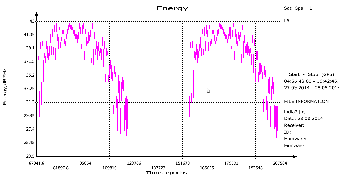
JAVAD GNSS has published a chart showing that it has tracked the IRNSS (Indian Regional Navigational Satellite System) L5 signal.
Shortly after the Indian Space Research Organization (ISRO) released its IRNSS Signal in Space Interface Control Document (ICD), JAVAD GNSS was able to track the L5 BPSK signal from both 1A and 1B satellites. Ability to track IRNSS L5 will be added to all JAVAD L5-capable receivers in the near future, the company said.
SNR of two passes of 1A satellite (IGSO) over Moscow.
Summer 2014 will be one that the €6.3 billion (US$8.2 billion) Galileo GNSS programme will need to chalk down to experience and hope to move on from. At the time of my last EAGER column, we were starting to get a hint that one of the four in-orbit Galileo IOV satellites was not functioning. We now know that it has suffered a catastrophic power failure.
And in August, celebrations for a successful launch of the first two Galileo FOC satellites, named Doresa and Milena, quickly went sour when it became clear that they had suffered an anomaly during launch. And a very big anomaly at that.
We are still awaiting the preliminary results from the inquiry set up by the European Space Agency (ESA), the European Commission, and the rocket’s operator Arianespace. It is hoped that the results of the inquiry board will be available at the end of September.
ESA spokesperson Franco Bonacina informs me that on the satellite side, ESA’s teams at the ESOC control centre are investigating the possibility of partially raising or modifying the orbit of the two satellites, which are fully under control and in good health. They are also considering performing some software adaptations on board the spacecraft and at ground station level to try and make them “be seen” as operational satellites and able to provide operational services within the Galileo system. All this is still “work in progress” and it will take a few more weeks to be fully evaluated and put into practice.
So, what went wrong?
In the absence of firm conclusions from the inquiry, the rumour mill has been running at full throttle with the wide range of theories from cock-up to conspiracy.
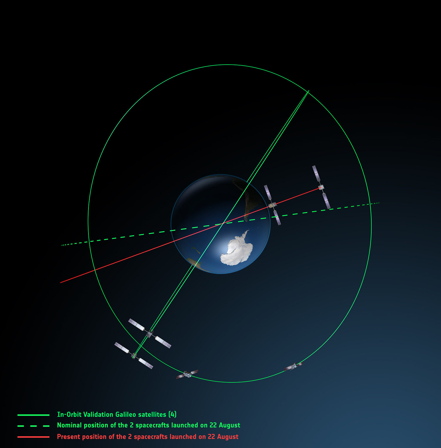
What we do know is that the Galileo craft were supposed to be launched by a Soyuz-Fregat rocket into a circular orbit 23,222 kilometres above the Earth and angled at 56 degrees to the planet’s equator. The initial launch from Kourou, French Guiana, on August 22 seemed to be smooth and nominal, but something went wrong in the final stages of the flight, and the two satellites were placed in an elliptical orbit varying from more than 2,000 kilometres too high to nearly 10,000 kilometres too low and also tilted by about 5 degrees from the intended plane.
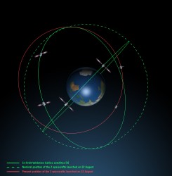
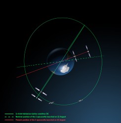
Galileo orbits viewed side-on.
Galileo orbits viewed from above.
The most plausible explanation for the anomaly is that the Soyuz – Fregat upper stage suffered a control malfunction at some point before its final orbital injection burn. So although the rocket engine seems to have fired correctly, the craft wasn’t pointing in the right direction.
In fact, I am told that a likely mechanical root cause for the anomaly in the Fregat stage has been identified by the inquiry committee; however, more information is being gathered and further technical analysis is required to verify this.
Can anything be done?
Doresa and Milena do not have enough fuel on board to achieve the correct orbit for full Galileo operations.
Some interesting solutions have been proposed to launch a rescue mission to drag the errant satellites into their correct orbit, but that could be a slow, risky and expensive exercise. So could the satellites be useful in situ?
For most GNSS uses, the answer is probably no. Despite the fact that the satellites themselves are apparently working perfectly, in a safe state, correctly pointing towards the Sun, properly powered and fully under control of the ESA team, their elliptical orbit does not conform with Galileo’s standardized data format. For example, the value that represents the shape of the satellites’ orbit is too big to be expressed within the allotted bit limit for that parameter.
Marco Falcone, ESA’s Galileo system manager, says his team have been working intensely to determine if the satellites can be at least partially recovered. Among the considerations are the flight dynamics of moving the two spacecraft and the impact of the radiation they are experiencing in their current location, which can shorten the satellite’s lifetime. “It’s very dangerous for the satellite,” admits Falcone.
Another unknown is the timing performance of the satellites’ rubidium frequency and hydrogen maser given the relativistic effects of their orbit. Signal issues, such as the navigation message almanac, also must be considered before the FOC satellites can be introduced into operation, Falcone said.
Good for geoscience?
But according to fellow GPS World contributor Richard Langley of the University of New Brunswick, the situation is more hopeful for scientists wanting to use Galileo-derived data in their research. Quoted in an article in leading science journal Nature, Richard says that researchers tracking GNSS satellites via the IGS global network of ground stations combine that information with the timing data transmitted by the satellites themselves and could use it to measure changes in the position of points on the ground much smaller than the one-metre margin of error for standard navigation-system receivers. This level of precision is good enough to detect millimetres of movement in tectonic plates, for example.
This reminded me of a presentation by a team of Italian scientists I saw recently. The VADASE (Variometric Approach for Displacements Analysis Stand-alone Engine) project uses a novel strategy consisting of an algorithm able to perform real-time retrieval and estimation of displacement and waveforms based on high-frequency (1 Hz or more) carrier phase observations collected by a stand-alone GNSS receiver. The algorithm works with broadcast data (satellite clocks and orbits), requires very simple hardware, and has demonstrated potential application in real-world situations such as earthquake risk assessment (and related early-warning systems for tsunamis) and structural monitoring (see citations below). VADASE had already achieved a Galileo-only displacement solution using the four IOV satellites in orbit.
I contacted Gabriele Colosimo at Rome’s “Sapienza” University, and he confirmed that, although the satellites could not be used for direct gravimetric studies that require a very low orbit (below 1,000 km), the data from Doresa and Milena could be used to estimate displacements of GNSS receivers. He and the VADASE team think that a slight adjustment in their algorithm might be needed depending on the exact orbit parameters of the satellites, but the data would be useable without any significant change in orbit being required.
Gabriele also thinks that the data could be used to usefully contribute to studies in fields such as troposphere studies and GNSS reflectometry, as well as for geodynamic and seismic monitoring using GNSS.
Munich Masters
Hopefully the mystery of Doresa and Milena’s anomaly will have been resolved by October 23, when the 2014 European Satellite Navigation Competition (ESNC) awards ceremony takes place in Berlin in conjunction with the two-day Satellite Masters Conference.
But the real prize for the European GNSS community would be a full explanation of the recent Galileo issues, and how they are being resolved, and a clear statement and timeline on the future deployment and implementation of this flagship programme.
A bientôt – as they say in these parts
Citations
G.Colosimo, M. Crespi and A.Mazzoni, “Real-time GPS Seismology with a stand-alone receiver: A preliminary feasibility demonstration,” Journal of Geophysical Research, vol 116, doi: 10.1029/2010JB007941
M. Branzanti, G.Colosimo, M.Crespi and A.Mazzoni, “GPS near-real-time coseismic displacements for the great Tohoku-oki earthquake,” IEEE Geoscience and Remote Sensing Letters, vol 99, doi: 10.1109/LGRS.2012.2207704
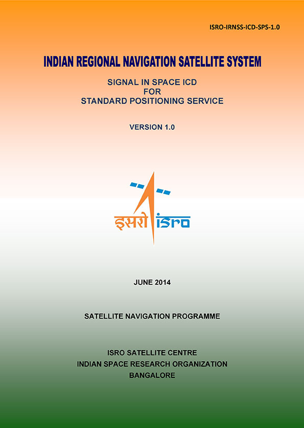
The Indian Space Research Organization (ISRO) has released Version 1 of the Indian Regional Navigational Satellite System (IRNSS) Signal in Space Interface Control Document for the Standard Positioning Service.
The document provides information on the signals and structures of the IRNSS system, including signal modulations, frequency bands, received power levels, the data structures and their interpretations, and user algorithms.
According to ISRO, the document is being released to the public to facilitate research and development and to aid the commercial use of the IRNSS signals for navigation-based applications.
Registration is required for ICD download access at a new IRNSS website. At the moment, only the ICD is available at this website.
The next IRNSS satellite launch is scheduled for the second week of October. The most recent launch was in April, of the second IRNSS satellite, IRNSS-1B.
IRNSS is an independent regional navigation satellite system being developed by India. It is designed to provide accurate position information service to users in India and the region extending up to 1,500 kilometers from its boundary. IRNSS will provide two types of service: Standard Positioning Service (SPS) and Restricted Service (RS). It is expected to provide a position accuracy of better than 20 meters in the primary service area.
Galileo’s first two full-operational capability (FOC) satellites have been in a safe state since August 28, under control from the European Space Agency’s (ESA’s) center in Darmstadt, Germany, despite having been released on August 22 into lower and elliptical orbits instead of the expected circular orbits.
ESA continues investigating the possible exploitation of the out-of-position satellites to maximum advantage, despite their unplanned injection orbits and within the limited propulsion capabilities. ESA specialists, supported by industry and France’s CNES space agency, are analyzing different scenarios that would yield maximum value for the program, and safeguard — as much as possible — the original mission objectives.
Galileo orbits viewed from above: Orbits of the fifth and sixth satellites in red, compared to their intended position in dashed green, and the position of the four satellites launched in 2011 and 2012 in solid green. This view looks down over the South Pole to illustrate how the inclination relative to the equator is less than intended. The satellites are in an elliptical rather than circular orbit, with a maximum altitude of about 25,900 km and a minimum altitude of about 13,700 km, compared to a planned circular orbit of 23,222 km altitude.
Experts representing the Galileo Program provided a frank and open update at the ION GNSS+ conference in Tampa on September 10, as reported by Richard Langley:
An inquiry board is looking into problem to find the root cause of the anomaly. The board has already met several times.
An intermediate report is due shortly; a final report and recommendations will come next month.
ESA is considering what can be done with the two satellites; ESA hopes to be able to use them operationally as much as possible.
ESA is also looking at the impact on the commercial Galileo service and the search-and-rescue service.
ESA is narrowing down the possible causes of the anomaly.
ESA is waiting for the enquiry board to report before deciding on when and how the next two satellites will be launched.
The payloads of the errant satellites are currently off.
ESA wants to try to raise the perigees of the satellites to get them out of the van Allan radiation belt as soon as possible to prevent damage to the satellites. Raising the perigrees will also to reduce the maximum Doppler frequency shift from 9.6 kHz to at least 6.8 kHz to allow receivers to easily acquire and track the satellites, but leave enough hydrazine for future station keeping.
ESA is looking at the almanac problem and whether unused bits in the Galileo navigation message might be able to support a special almanac for the satellites.
ESA is also looking at possible rephasing of the satellites to optimize their use with the other satellites in the constellation.
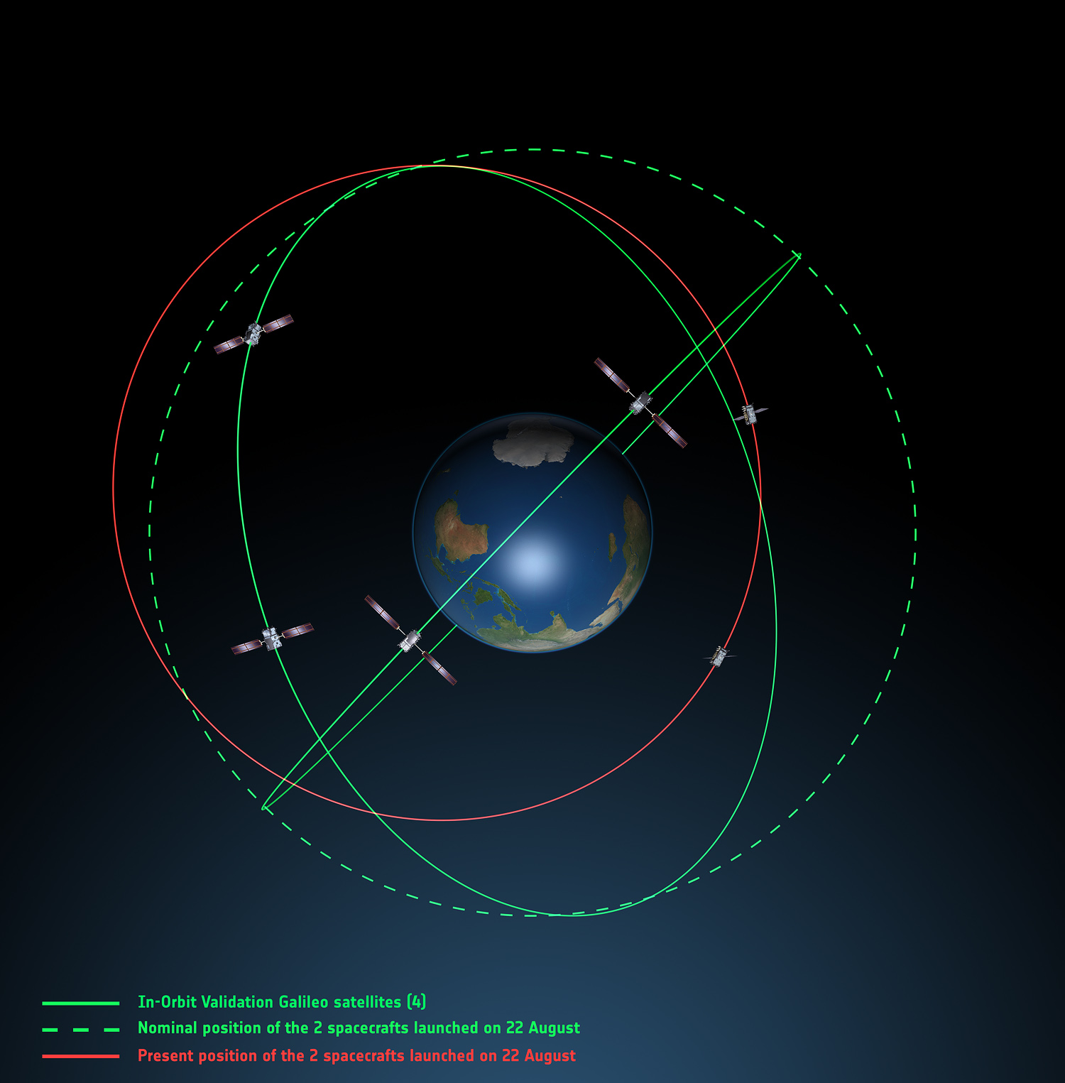
Galileo orbits viewed side-on: The fifth and sixth Galileo satellites in red, compared to their intended position in dashed green, and the position of the four satellites launched in 2011 and 2012, in solid green. This view looks side on to the two satellites’ orbital plane, which is off-center relative to Earth. The targeted orbit was circular, inclined at 55º to the equator at an altitude of 23,222 km.They are in a safe state, correctly pointing towards the Sun, properly powered and fully under control of an ESA–CNES team.
Soyuz at Fault? On August 28, the Russian newspaper Izvestia reported that “The failure of the European Union’s Galileo satellites to reach their intended orbital position was likely caused by software errors in the Fregat-MT rocket’s upper stage.”
“The nonstandard operation of the integrated management system was likely caused by an error in the embedded software. As a result, the upper stage received an incorrect flight assignment, and, operating in full accordance with the embedded software, it has delivered the units to the wrong destination,” an unnamed source from Russian space Agency Roscosmos was quoted as saying by the newspaper.
An independent inquiry panel has been set up by Ariane and headed by former ESA Inspector General Peter Dubock. It started work on August 28. The panel includes a couple of academics and a majority of ESA and EC figures.
The new EC commissioner in this area, Ferdinando Nelli Feroci, invited ESA and Arianespace to his study during the first week of September to present the initial results of the inquiry.
The commissioner commented, “The problem with the launch of the two Galileo satellites is very unfortunate. The European Commission will participate in an inquiry with ESA to understand the causes of the incident and to verify the extent to which the two satellites could be used for the Galileo programme. I remain convinced of the strategic importance of Galileo, and I am confident that the deployment of the constellation of satellites will continue as planned.”
The commissioner expects that the Galileo constellation will be fully deployed by the end of this decade. This may qualify as optimism because system planners had envisioned for six spares — and three are already blown.
Ariane and ESA did not insure the satellites.
According to back-of-the-envelope calculations, system operators are now one short of the minimum 24 needed for full 24/7 global coverage, as they have four in orbit validation satellites up (one broken) and 22 FOCs on order (two launched and now in what could be called a junk orbit), which makes a potential maximum 23 satellites that have actually been ordered — one short of the target.
The Satellites Are Alright. Satellite manufacturer OHB Systems of Bremen, Germany, issued a release stating that “Controllers at ESA’s ESOC control centre in Darmstadt, Germany, confirm the good health and the nominal behavior of both satellites. They are in a safe configuration, are thermally stable, have stable pointing to the sun and sufficient power production. All platform subsystems have been checked and they work properly. Also, the procedures to deploy the solar arrays are successfully performed and all solar arrays are properly unfolded.”
Further, “The orbit anomaly has no impact on the production and delivery of the in total further 20 satellites. Two FOC satellites are currently at ESTEC test facilities in Noordwijk, the remaining are in various status of integration. ”
Blogs Alive; BBQ Mode. The chairman of the Executive Board of the German Aerospace Center, Johann-Dietrich ‘Jan’ Wörner, writes an interesting blog. A recent installment opened with a quote from Elon Musk: “Rockets are tricky.”
Wörner went on to say, “The Soyuz launcher lifted off from the European Spaceport in French Guiana. Initially, all of the measurements suggested a perfect mission; the launcher took off at the scheduled time, followed the prescribed trajectory, and the stage separation was carried out correctly. However, the first problem became apparent when the two satellites proved unable to deploy their solar arrays as intended. A more detailed analysis then revealed that the eccentricity, the altitude and the inclination of the satellites’ orbits with respect to Earth’s equator did not meet the specifications. The upper stage had also evidently failed to induce the planned rotation around the longitudinal axis of the spacecraft (known as ‘barbeque’ mode, designed to maintain favourable thermal conditions during exposure to the Sun).”
Further discussion of the possible causes of the anomaly can be found on a Russian site, which focuses on the Fregat stage thrusters and indicates that the Russians think the barbeque maneuver was completed, and thus not the problem.
The other big issue is how the telemetry didn’t pick up the issue straight away.
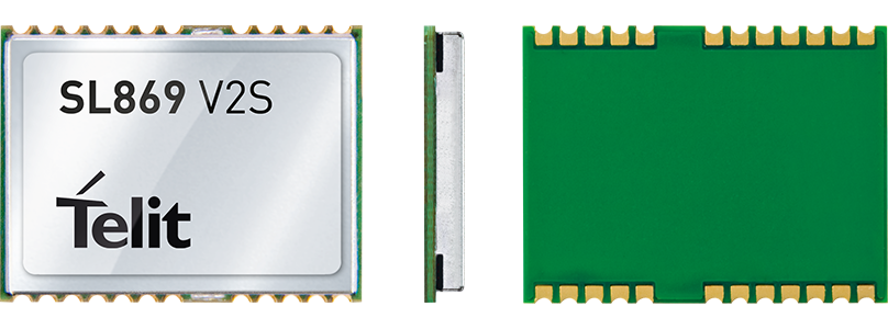
The Jupiter SL869-V2S GPS module. Photo: Telit Wireless Solutions
Telit Wireless Solutions, a global provider of high-quality machine-to-machine (M2M) modules and services, today debuted the Jupiter SL869-V2S GPS module, designed for easy migration between a full-GNSS solution for top-ranked applications and a simple GPS-only solution for less demanding applications.
The Jupiter SL869 V2S supports GPS as well as QZSS constellations and is ROM based. Geo-location data is delivered using NMEA protocol through a standard UART port. It supports ephemeris file injection (A-GPS) as well as Satellite Based Augmentation System (SBAS) for increased position accuracy. Its onboard software engine is able to locally predict ephemeris three days in advance starting from ephemeris data broadcast by GNSS satellites, received by the module and stored in the host flash memory.
Key benefits include:
Pin-to-pin compatibility with JN3/xL869 family
Same protocol used in SL869 V2
Straightforward migration between full-GNSS solutions and GPS-only solutions
SBAS support, for increased position accuracy
Assisted GPS
The SL869 V2S can replace the JN3, SL869 or SL869 V2 — allowing customers to design once and interchangeably mount the appropriate solution depending on the required features. The xL869 is Telit’s GNSS unified form-factor family, which allows customers to select among different GNSS technologies and feature sets. Modules in this family are offered in a 16 x 12.2 mm, 24-pad, LCC package.
“The new SL869 V2S module is designed to be easily swapped with other xL869 modules for enhanced simplicity and scalability,” said Taneli Tuurnala, CEO of Telit GNSS Solutions. “It is an ideal example of how buying a module from Telit enables our customers to avert the need to keep track of the latest chipset technology on their own. We keep them on top of the best available technology, pre-packaged in a module that is easy to replace as needed, without having to redesign their entire application to stay up to date.”
Handheld Group, a manufacturer of rugged mobile computers, has launched the Nautiz X8 rugged PDA. The Nautiz X8 is a handheld computer with superior processing power, screen performance and battery life, the company said. It is built for tough field conditions primarily in GIS, land surveying, public safety, forestry and the military.
The Nautiz X8 is built to enable efficient and reliable data collection in tough environments. It has an IP67 ingress protection rating, which means it offers complete protection against dust and sand and can withstand immersion in water. It also meets stringent MIL-STD-810G military test standards for overall durability and resistance to humidity, shock, vibration, drops, salt and extreme temperatures.
The Nautiz X8 features a high-performance Texas Instruments 4470 dual-core 1.5 GHz processor. It has 1 GB of RAM, 4 GB of iNAND Flash and a 5200 mAh Li-ion battery that lasts up to 12 hours on a single charge. It comes with a choice of operating systems — Android 4.2.2 or Windows Embedded Handheld 6.5.3.
The device has a large 4.7-inch ultra-bright capacitive multi-touch screen with chemically strengthened Asahi Dragontrail glass, offering users brightness and protection in any field condition. The unit has an ergonomic design and weighs 490 grams (17.3 ounces).
The Nautiz X8 has a dedicated u-blox GPS receiver, Bluetooth 2.0 and 802.11b/g/n WLAN functionality, as well as connectivity through GSM/UMTS or CDMA phone data transmission. A built-in 8-megapixel camera with autofocus and an LED flash lets users capture visual data quickly and easily. This handheld also features an open architecture and an extension cap system that allows for additional hardware connections such as sensors, radios and other add-ons.
Orders for the new Nautiz X8 can be placed immediately. First deliveries will begin in November.
The Nautiz X8 rugged handheld will be shown first at WEFTEC in New Orleans, followed by InterGeo in Berlin.
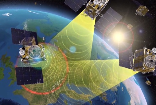
EGNOS is Europe’s first venture into satellite navigation. EGNOS broadcasts augmented information through a trio of geostationary satellites linked to a network of monitoring ground stations, to sharpen the accuracy and reliability of GPS signals across the continent. Photo: EGNOS
Europe’s EGNOS augmentation system sharpens the accuracy and reliability of GPS signals so they can safely be used for landing approaches across a growing number of European airports. But aviation is a global enterprise — so the aim is to develop a seamless network of augmentation systems in future.
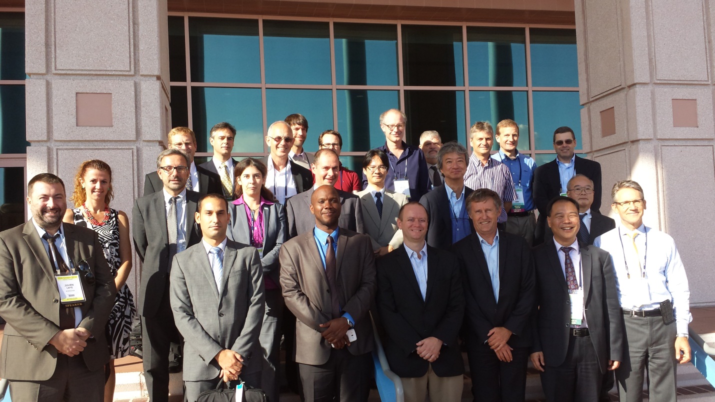
That is the task of an international group of experts, the Satellite Based Augmentation Systems (SBAS) Interoperability Working Group (IWG), whose 27th meeting took place in Tampa, Florida, September 8-10, hosted by the Institute of Navigation.
Satellite augmentation systems combine dedicated ground stations and satellite transponders to sharpen satnav accuracy and provide integrity data — providing continuously updated reliability levels — across given geographical regions. These systems are based on GPS for now, but plans are to move to a multi-constellation design in the post-2020 era, making use of Europe’s Galileo, China’s Beidou and Russia’s GLONASS systems as well.
SBAS providers from around the globe gathered at Tampa, Florida, for the latest meeting of the SBAS Interoperability Working Group September 8-10. IWG 27 was hosted by the Institute of Navigation. Photo: SBAS
SBAS systems enhance any type of location-based satnav use, but in practice, aviation is the main driver. The ESA-developed European Geostationary Navigation Overlay Service, EGNOS, commenced its general-public Open Service in 2009, with the Safety-of-Life Service for aircraft vertical landing approaches following in 2011.
For next-generation SBAS systems, the IWG is designing a multi-constellation and dual-frequency standard for heightened accuracy and reliability, building up to offering SBAS coverage on a worldwide basis.
Didier Flament, representing ESA — which co-chaired this IWG meeting with the U.S. Federal Aviation Authority — commented: “Among the achievements of the Tampa IWG has been the presentation of an ongoing review of a standard message definition for the new and second SBAS channel — known as L5 — of the second-generation SBAS system, to be used along with the current L1 signal.
ASECNA Member States.
“A single definition coordinated between ESA and the European Commission on one side and the U.S. Federal Aviation Administration on the other is progressing. The formal IWG review loop has started, with the aim of finalizing the convergence for early 2015. The aim is to have it ready to submit to the international SBAS standardization bodies — the International Civil Aviation Organization (ICAO), the U.S. Radio Technical Commission for Aeronautics and the European Organization for Civil Aviation Equipment — in the first quarter of next year.”
The meeting also introduced two new SBAS development projects, adding to the five existing projects presented at IWG 26. The first was presented by the Agency for Air Navigation Safety in western Africa and Madagascar (ASECNA), a public international organization with 18 member states.
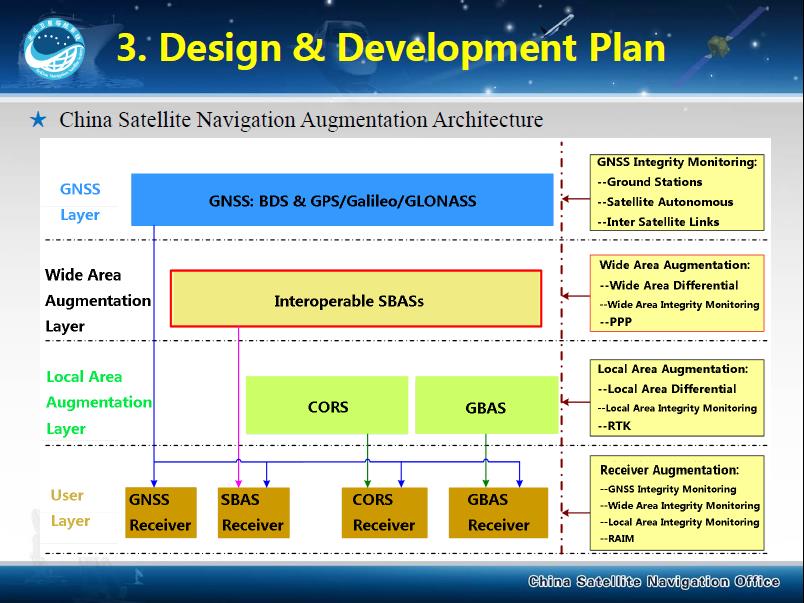
China’s BeiDou SBAS development plan, presented at IWG 27 in September 2014.
ASECNA’s project aims to take a two-step approach, commencing with EGNOS-style vertical landing guidance for selected airports, based on EGNOS constituents, with a tentative schedule of 2018, moving to upgrade to the dual-frequency multi-constellation service across the whole of ASECNA airspace after 2020.
The second new project is China’s own BeiDou SBAS. After discussions at ICAO level, China has committed to delivering SBAS services over China that are fully compliant with ICAO standards.
“This new plan has been highly welcomed by the aviation community and other SBAS providers,” Didier said. “Chinese representatives have also confirmed their intention to become part of the SBAS IWG and contribute to the work done to finalise the future standard.”
The follow-up IWG meeting will take place in February 2015 and will be hosted by ASECNA in Dakar, Senegal.
About EGNOS
EGNOS, the European Geostationary Navigation Overlay Service, is Europe’s first venture into satellite navigation. Its development was managed by the European Space Agency (ESA) under a tripartite agreement with the European Commission (EC) and the European Organization for the Safety of Air Navigation (Eurocontrol).
The ownership of the EGNOS assets was transferred from ESA to the EC in April 2009 and EGNOS officially entered service on October 1, 2009. The service is delivered, through a contract with the European GNSS Service Agency (GSA), by the European Satellite Services Provider, ESSP SaS, founded by seven air navigation service providers. ESA is the design and procurement agent for EGNOS on behalf of the EC.