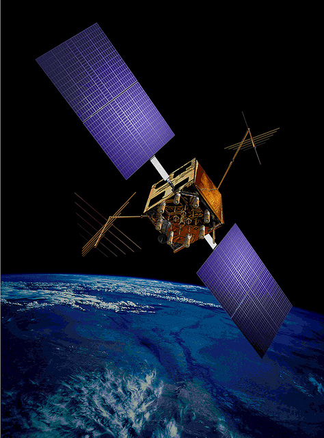
The U.S. Air Force’s fleet of GPS Block IIR and IIR-M satellites, manufactured by Lockheed Martin, have reached 200 collective years of operational life. The 20 satellites make up about two thirds of the current GPS constellation.
Originally launched between 1997 and 2009 to add capabilities to the GPS constellation and to replace other aging satellites, the 12 GPS IIR and eight IIR-M satellites have maintained an availability record of 99.96 percent, which represents only 10 minutes of down time per satellite during all their years of operation.
The 200-year milestone will be celebrated with a brief cake-cutting “ceremony” during ION GNSS, on Wednesday at 12:30 p.m., at the Lockheed Martin booth.
“This is a tremendous GPS operations and sustainment performance milestone, and we applaud the men and women of the Second Space Operations Squadron of the Air Force’s 50th Space Wing, as well as the industry team who support them,” said Mark Stewart, vice president for Lockheed Martin’s Navigation Systems mission area. “The world relies on GPS every day for things like synchronizing global banking and investing, shipping and transportation, search and rescue operations, ATM transactions and even precision farming.”
This spring, the IIR-M satellites played a major role in the continued modernization of the GPS constellation. To help manufacturers develop and test next-generation advanced civil GPS receivers, under the direction of Air Force Space Command and in collaboration with the Department of Transportation, these satellites began early broadcasting of test civilian navigation, or CNAV, messages on a new signal planned for all future satellites.
Making these milestones even more significant is the fact that the GPS IIR and IIR-M satellites were designed to last 7.5 years, or collectively about 150 years. All 12 IIR satellites are currently operating beyond their design life with the oldest operating for more than 16.5 years. Three of eight GPS IIR-M satellites have surpassed their expected life span and all satellites will have done so in 2017.
To meet evolving GPS user demands, Lockheed Martin is developing the next-generation GPS III satellites. These satellites will deliver three times better accuracy, provide up to eight times improved anti-jamming capabilities, and include enhancements which extend spacecraft life to 15 years, 25 percent longer than the newest Block IIF satellites. GPS III will be the first generation of GPS satellite with a new L1C civil signal designed to make it interoperable with other international GNSS.
Starting Friday, September 5, GPS satellite SVN-35 will resume transmitting L-band signals using PRN03, according to a Notice Advisory to Navstar Users (NANU) issued today.
According to GPS WorldAlmanac editor Richard Langley, the resumption is being done in an effort to determine the exact status of SVN-35’s remaining clock. However, the satellite will remain unusable as the Air Force conducts its tests.
Below is the full text of the NANU.
NOTICE ADVISORY TO NAVSTAR USERS (NANU) 2014069 NANU TYPE: GENERAL
*** GENERAL MESSAGE TO ALL GPS USERS ***
On approximately 05 Sep 2014 SVN35 will resume transmitting L-band utilizing PRN03. At L-band activation, SVN35/PRN03 will be unusable until further notice. Additionally, no broadcast almanacs will include SVN35/PRN03 until further notice.
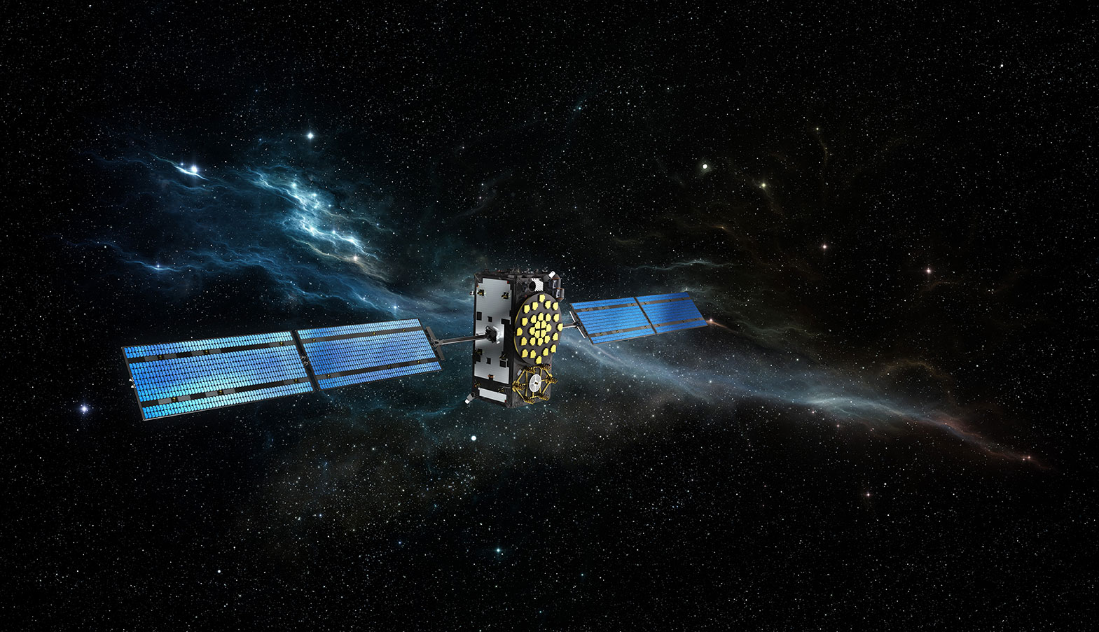
The year 2014 is most certainly the Year of Galileo.
After rising up from near elimination in 2008 due to much confusion about how to fund it, the European Union, that same year, decided to allocate 3.4 billion euros to fund the ground infrastructure and the initial satellites. Unlike the U.S. GPS and Russian GLONASS systems, Galileo is civilian-funded as opposed to being funded primarily from defense budgets, which makes it politically much more difficult to gain funding. But, they did it.
That was six years ago.
Since then, ground infrastructure has been designed and built. Six test satellites have been designed, built and successfully launched into orbit. In early 2013, the first position fix using only Galileo satellites was achieved. With all the necessary test satellites launched and systems tested, the anticipation of FOC (Full Operational Capability) satellite launches has been high, because it would signal the rapid deployment of the Galileo navigation system that would so complement GPS and so benefit the high-precision GNSS user community.
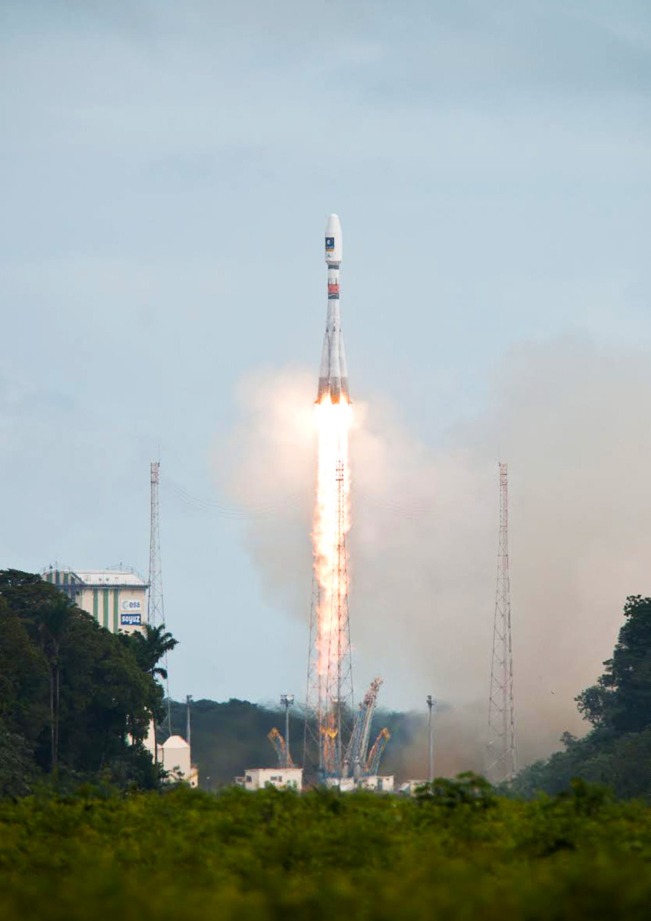
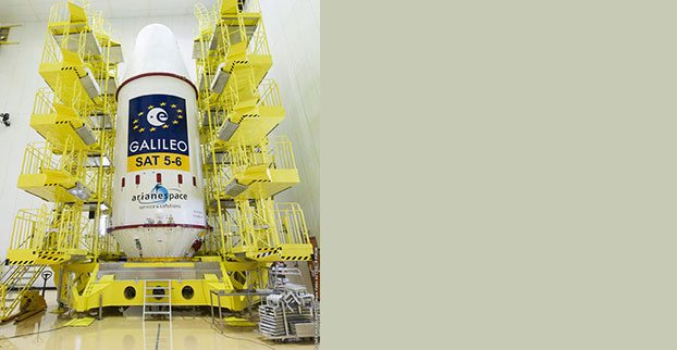
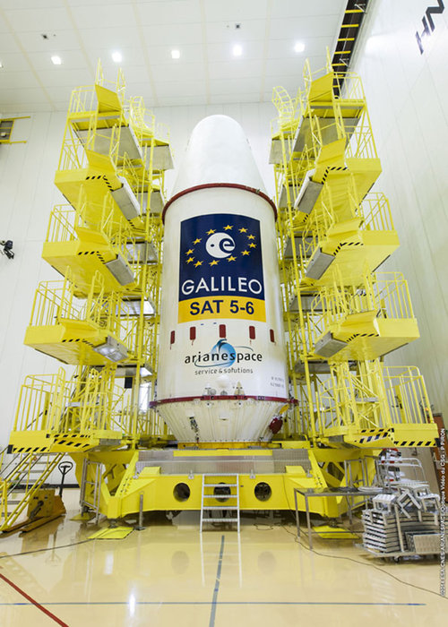
Soyuz Flight VS09, carrying Europe’s fifth and sixth Galileo satellites, lifts off from Europe’s Spaceport in Kourou, French Guiana.
That moment arrived last month, on August 22, with the launch of the first two Galileo FOC satellites. The significance of the first FOC launch is that it would trigger an aggressive launch schedule comprised of one launch every three months, at two satellites per launch — equaling eight satellites launched per year. With four test satellites already in orbit being converted to operational satellites, one can envision 16 Galileo satellites in orbit by the end of next year. While not a complete constellation at that point, it would offer plenty of upside — worldwide I might add, as I’ve written about in the past — by adding more satellites in view and accelerating the adoption of the new L5 signal, which is also supported by GPS.
Between Europe deploying Galileo and China deploying its BDS (BeiDou) system, the world of high-precision GNSS is going to change a lot in the next couple of years. There will be more receiver choices at much lower prices for RTK receivers.
But, the satellite navigation business is not a forgiving one. The devil is in the details, and the number of details has got to be overwhelming. Consequently, there have been many casualties.
The Russians have taken their lumps, losing a total of seven GLONASS satellites to faulty rocket launches in just the past four years.
In 2009, the U.S. placed into orbit a GPS satellite, SVN-49, that never has been set healthy, rendering it a “$100M test satellite.”
Now, the Europeans have joined the club.
The “pucker factor” during the satellite launches is always high, so on August 22, when two Galileo satellites mounted on a Russian Soyuz rocket at the Arianespace launch pad in French Guiana were pushed up into space, there must have been a sigh of relief that the launch seemed to go smoothly. Even I was excited, Tweeting “#Galileo Launch Successful, Satellites Deployed. Booyah!”, shortly after the launch.
However, looks can be deceiving.
It turns out that somehow, some way, the two Galileo satellites, after years of planning, were inserted into the wrong orbits.
The liftoff and first part of the mission proceeded nominally, reports Arianespace, leading to release of the satellites according to the planned timetable, and reception of signals from the satellites. However, the targeted orbit was circular, inclined at 55 degrees with a semi major axis of 29,900 kilometers. The satellites are now in an elliptical orbit, with excentricity of 0.23, a semi major axis of 26,200 km and inclined at 49.8 degrees.
With navigation satellites, we’ve seen disastrous launch failures and defective satellites placed in orbit, but I can’t recall ever hearing about navigation satellites being inserted into the wrong orbits. It’s difficult not wonder how such a seemingly simple error could occur, yet sympathize with the Galileo program managers given the complexity of the task, but also appreciate the consistency and reliability of GPS satellite deployments.
Galileo satellites fastened to upper stage.
The Russians quickly commented on the satellite deployment anomaly since it was a Russian Soyuz rocket launcher, speculating that it was a software bug. The Russian newspaper Izvestia quoted an unnamed source from the Russian Space Agency Roscosmos that “the failure of the European Union’s Galileo satellites to reach their intended orbital position was likely caused by software errors in the Fregat-MT rocket’s upper stage.”
It’s too early to say if the Galileo satellites will ever become serviceable. The Monday following the launch, an independent inquiry commission was formed to “establish the circumstances of the anomaly, to identify the root causes and associated aggravating factors, and make recommendations to correct the identified defect and to allow for a safe return to flight for all Soyuz launches from the Guiana Space Center (CSG).”
This subject will certainly be a hot topic at the Institute of Navigation (ION) GNSS conference being held next week in Tampa, Florida. A full staff of GPS World editors and administration folks will be attending, including yours truly. It’s the premiere GNSS technical event of the year, so I’m sure there will be plenty of scientists and program managers commenting and speculating on the future of these two satellites.
If you’d like the latest news on this and other GNSS-related subjects during the conference next week, follow me on Twitter at https://twitter.com/GPSGIS_Eric. There are lots of interesting subjects at the ION GNSS+ conference. Take a look at the conference agenda here. I’ll be attending many of the presentations related to high-precision GNSS and report to you in next month’s newsletter. To give you a flavor, following are some of the presentations that I’m going to try to attend.
The Triple-frequency Multi-system RTK Engine for Challenging Environments
Mobile Mapping Using Smartphone
Analysis of Using Smartphones for Indoor Mobile Mapping
GPS Program update
Galileo Program Update
Glonass Program update
BDS Program update
GLONASS Only and BeiDou Only RTK Positioning
Comparing Multi-constellation and Multi-frequency Based on GPS/Beidou RTK Positioning
Combined GPS+BDS+Galileo+QZSS for long single-baseline RTK positioning
Real-time PPP with Galileo, Paving the Way to European High Accuracy Positioning
High-Precision GNSS — What will it Look Like in 2020?
CartoPac International Inc. has announced a major new release of the CartoPac Mobile Platform. CartoPac 5.0 extends the mobile platform with support for Windows 8 and introduces the CartoPac Workflow Manager, which provides a structured process to manage the use of geospatial data across the enterprise.
CartoPac will demonstrate the applications and technologies of Version 5.0 in the free CartoPac Mobility Webinar Series beginning on September 30.
The CartoPac Platform is a configurable suite of field and office tools designed to maximize the productivity of crews as they digitally map, inventory and inspect critical assets using GPS-enabled mobile devices. Seamlessly integrating with the Esri ArcGIS Server, CartoPac is used extensively by oil and gas companies, pipeline operators, electric utilities, state/local governments and environmental engineering firms to populate the enterprise GIS and asset-management systems with captured infrastructure information.
The new CartoPac Workflow Manager (CWM) in CartoPac 5.0 provides organizations with a structured workflow to view, edit, validate and approve asset data as it moves from the field back into the enterprise. CWM ensures that individuals responsible for data are notified as it comes into the organization so they can incorporate the data into systems related to work-order fulfillment, risk analysis, integrity modeling and other asset management processes.
CartoPac developed CWM for the management of heavily regulated assets in the field, such as gas pipelines and electric distribution infrastructure. A module within the CartoPac Server, the CWM extension creates an audit trail of all the edits and modifications made to the data sets that represent the monitoring and maintenance of real world assets in the field.
“CartoPac Workflow Manager fills the gap between data collection and enterprise asset management systems to enable organizations to maximize the value of their data,” said CartoPac CIO Scott Crouch. “CWM enables organizations to show regulators they have a structured process for tracking and responding to the conditions of their critical assets and has proven to be key component for assisting companies with their regulatory compliance and integrity management programs.”
Further expanding the capabilities of the CartoPac mobile components, version 5.0 has been optimized for the Windows 8 operating system running on standard GPS-enabled laptop computers and tablet devices. This migration means that crews can use CartoPac to collect and manage asset data in the field on the same hardware devices they will use back in the office to run their daily business applications.
“The attractive cost, integration with GPS and expanded performance of Windows 8 tablets and laptops will enable organizations to put more personnel into the field, ensuring that vital infrastructure is mapped, inventoried and properly managed,” said Crouch “Laptop/tablet-equipped maintenance personnel in the field will now be able to run CartoPac solutions on the hardware they already use for tracking repairs and closing work orders.”
To demonstrate the advantages of enterprise asset management, CartoPac has launched the CartoPac Mobility Webinar Series, which will feature applications by electric and gas utilities and highlight new mobile technologies. The first webinar, “Applying New Mobile Technologies to Electric Utility Inspections,” will be presented with EDM International Inc., a Colorado electric utility services company.
The free “Applying New Mobile Technologies to Electric Utility Inspections” webinar will be held on September 30, 2014, at 4:00 pm Eastern Time. To register, click here.
Abstract submissions are now being accepted for The Institute of Navigation’s (ION) Pacific PNT Conference, to be held April 20-23, 2015, at the Waikiki Beach Marriott, Honolulu, Hawaii. Abstracts are due November 14, 2014.
Pacific PNT, where “East Meets West in the Global Cooperative Development of Positioning, Navigation and Timing Technology,” brings together policy and technical leaders from Japan, Singapore, China, South Korea, Australia, the United States, and more for policy updates, program status and technical exchange.
“Global cooperative interoperability” will frame the technical program. Leaders representing academia, government, industry and the scientific community will convene to solve PNT challenges that impact Pacific Rim development.
Pacific PNT 2015 is organized by a Pacific Rim advisory board and will feature technical papers presented on a diverse array of topics including:
Aircraft Navigation and Surveillance
Agricultural, Construction and Mining
Algorithms and Methods
Alternative Navigation and Signals of Opportunity
Aviation Applications of GNSS
Challenging Navigation Problems
Collaborative Navigation Topics
Earthquake & Tsunami Prediction and Monitoring with GNSS
GNSS Augmentations
GNSS Correction and Monitoring Networks
GNSS Environmental Monitoring
GNSS Policy/Status Updates
GNSS Signal Structures
Inertial Navigation Technology and Applications
Interference and Spectrum
Ionosphere Monitoring with GNSS
Magnetic Field Navigation and Mapping
Maritime Navigation
Nature-Inspired Navigation
PNT and Automobile Safety
PNT and Social Media
PNT for Domestic and Healthcare Applications
Precision Agriculture and Machine Control
Time and Frequency Distribution
UAS Technologies
Abstracts are being accepted through November 14, 2014. For more information the ION’s Pacific PNT 2015, visit www.ion.org/pnt.
PTTI 2014 Registration Opens
Registration is now open for the ION Precise Time & Time Interval Meeting (PTTI) 2014 to be held December 1-4 at the Seaport Boston Hotel, Boston, Massachusetts. The technical program is available online.
The annual PTTI conference has a technical program designed to disseminate and coordinate PTTI information at the user level; review present and future PTTI requirements; inform government and industry engineers, technicians, and managers of precise time and frequency technology and its problems; and provide an opportunity for an active exchange of new technology associated with PTTI.
The Distinguished PTTI Service Award, which recognizes outstanding contributions related to the management of PTTI systems, will be presented on Thursday, December 4.
Galileo IOV Bird Mute; New Draft ICD; CS Proved; Late August Launch
Orbiting in silence since an onboard power mishap on May 27, troubled E20 emitted cheeps from space on August 6, 7, and 8, broadcasting on the L1 frequency. Nothing has been heard since.
Meanwhile, the European Commission (EC) published a new draft version of the Galileo Open Service Signal in Space Interface Control Document (OS SIS ICD), issue 1, revision 2, on June 30. It is available for download and comment, the latter period extending to September 22. The EC’s open public consultation process seeks to ensure that any further development of the Galileo OS SIS ICD takes into account the views of key GNSS stakeholders. An online form for submitting comments is available.
Galileo E20, also known as GSAT0104, the fourth in-orbit validation (IOV) satellite, has been set “unavailable until further notice” according to the European GNSS Service Centre because of a sudden, unexpected loss of power on May 27.
Based on a selected set of IGS MGEX stations and all CONGO stations, the first signals were tracked at AREG, AUT0, LLAG, and UNB3 at 23:13:00. No E5 signals and no navigation messages are currently transmitted. Some JAVAD GNSS receivers report from time to time false E5a locks with zero or extremely small C/N0.
Galileo’s Early Proof of Concept (EPOC) team has successfully tracked the encrypted Galileo E6-B and E6-C signals broadcast by Galileo satellites. As a result, the Commercial Service loop has been closed using both encrypted and non-encrypted signals.
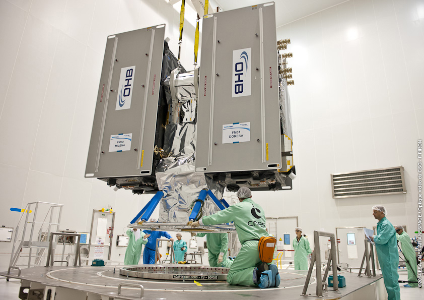
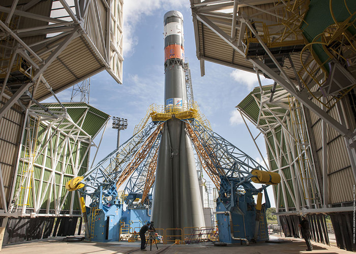
The completed dispenser unit is ready to be transferred from the S5 payload preparation facility for its integration atop Soyuz’ Fregat upper stage.
During a 10-day testing period, receivers in Tres Cantos, Spain and Poing, Germany, showed the successful tracking and data demodulation of the encrypted signals from the available Galileo satellites, with periods where all satellites transmitting E6 encrypted signals were tracked simultaneously. The tests verified the Galileo Commercial Service (CS) signal’s encryption functionalities, with the data received containing authentication and high accuracy information previously generated outside the Galileo system. This is an essential feature to ensuring Galileo’s high accuracy and authentication services.
The Galileo Commercial Service will deliver a range of added-value features, including positioning accurate to decimeter level and an authentication element. The Galileo CS demonstrator began its proof of concept earlier this year, with early service expected to start in 2016.
Once operational, the CS will provide access to two additional encrypted signals on the E6 band, delivering a higher data throughput rate and increased accuracy. The tests are the result of a collective effort involving teams and projects of AALECS (Authentication and Accurate Location Experimentation with the Commercial Service), supported by the European Commission, the GSA, the European Space Agency (ESA), and the Galileo operator Spaceopal.
The AALECS project is building a platform to connect to the European GNSS Service Centre (GSC) and transmit real-time CS data through the Galileo satellites. This platform will be operational by 2015 and will demonstrate the real performance of future high-accuracy and authentication services of Galileo prior to early service availability.
The European Commission launched AALECS in January 2014, and it was awarded to a consortium led by GMV including CGI, Qascom, IFEN, Veripos, and KU Leuven.
New Launch. At press time, the next Galileo satellites were set to launch on August 21, ushering in the system deployment phase and paving the way for the start of initial services. Galileo SATs 5 and 6 were scheduled to lift off from Europe’s Spaceport in French Guiana on top of a Soyuz rocket. They are expected to become operational, after initial in-orbit testing, in autumn.
The two satellites will join the four Galileo in-orbit validation satellites already in space. Launched in pairs in October 2011 and October 2012, these four — the minimum required to obtain a position fix — demonstrated and validated the system’s space and ground segments.
SATs 7 and 8 are scheduled to follow by end of year 2014. Then the constellation will be gradually deployed with six to eight satellites launched per year, along with addition of remaining elements of the ground network.
Adjacent-Band Compatibility Workshop Set for D.C.
The U.S. Department of Transportation is holding a “GPS Adjacent Band Compatibility Assessment Workshop” on September 18, 10 a.m.–5 p.m. Eastern Daylight Time. Registration for the workshop is required, and closes September 4. The general public can either attend in person or via WebEx.
The workshop is being held to discuss implementation of a GPS Adjacent Band Compatibility Assessment. Discussion will focus on the various implementation steps of the assessment, including development of GPS receiver use cases, identification of representative GPS receivers, and development of a test and analysis program. “In particular, emphasis will be placed on the information needed from GPS receiver and antenna manufacturers, and the logistics of procuring and handling that information to safeguard manufacturer proprietary data,” according to the Federal Register.
The sponsoring agency is the Office of the Assistant Secretary for Research and Technology, Department of Transportation.
The meeting will be held at the U.S. Department of Transportation, John A. Volpe National Transportation Systems Center, 55 Broadway, Cambridge, MA 02142. ID is required to enter the building. For details, see the Federal Register notice.
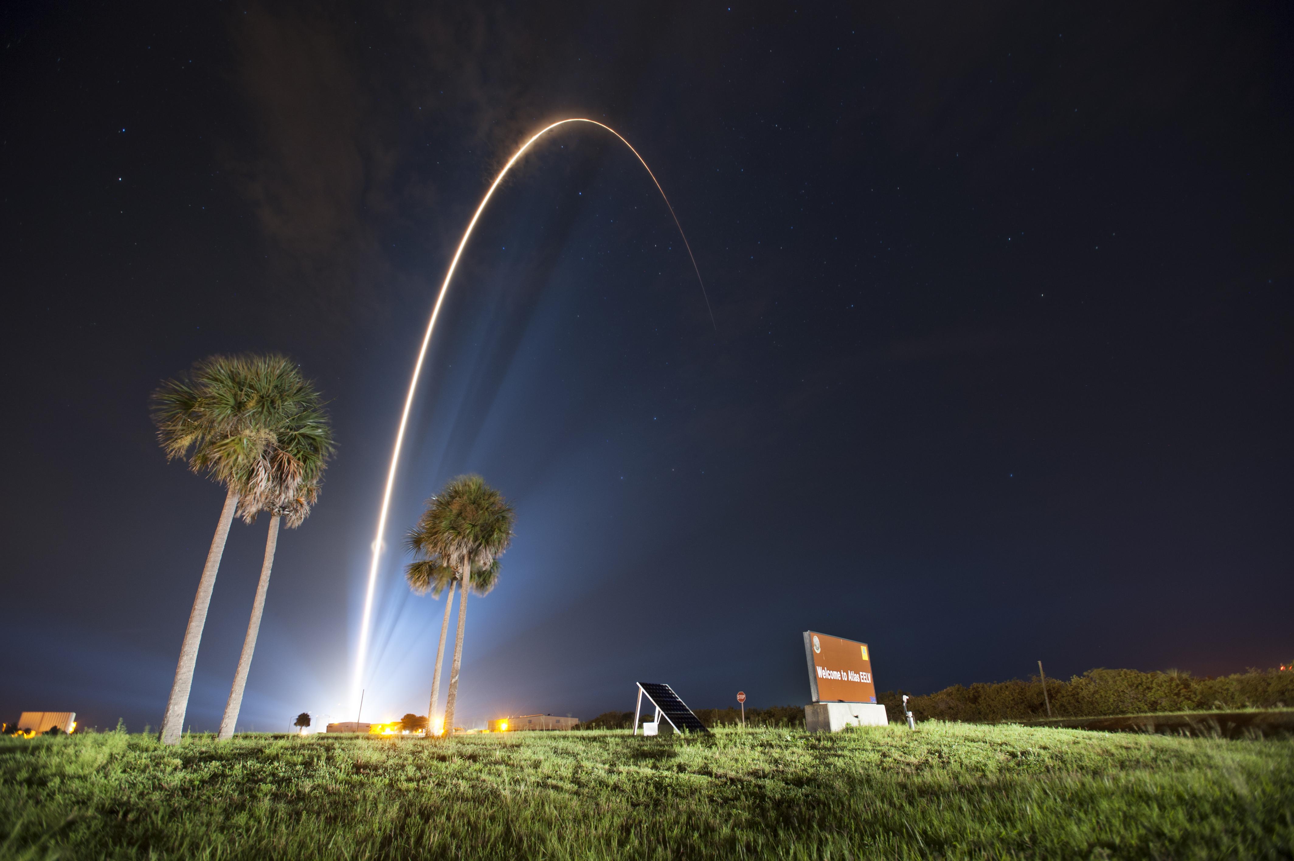
GPS IIF-7 Successfully Launched
Last USAF Launch to Rely on Radar as GPS Tracking Takes Over
A United Launch Alliance (ULA) Atlas V rocket carrying the seventh GPS IIF satellite for the U.S. Air Force launched at 11:23 p.m. EDT Friday, August 1 (03:23 UTC, August 2), from Space Launch Complex-41 at Cape Canaveral, Florida.The Boeing-built satellite has sent the signals to controllers that confirm it is currently operating properly within the constellation.
Boeing and the Air Force will complete the full on-orbit checkout of the satellite in August. The GPS IIFs offer improved signal accuracy, better anti-jamming capability, longer design life and the new civilian L5 signal.
“We are providing our Air Force partner and GPS users with a steady supply of advanced GPS IIFs,” said Craig Cooning, president of Boeing Network & Space Systems. “Our robust launch tempo requires vigilance and attention to detail, and mission success is our top priority. We continue to partner with the Air Force and ULA to effectively execute the launch schedule.”
GPS IIF-7 is the seventh of 12 such satellites Boeing has built for the U.S. Air Force, and the third on-orbit delivery this year. GPS IIF-8, slated for launch during the fourth quarter, arrived at Cape Canaveral on July 16 to undergo final launch preparations. GPS IIF-7 will join a worldwide timing and navigation system utilizing 24 satellites in six different planes, with a minimum of four satellites per plane positioned in orbit approximately 11,000 miles above the Earth’s surface.
“Congratulations to the U.S. Air Force and all of our mission partners on the successful launch of the Atlas V carrying the GPS IIF-7 satellite,” said Jim Sponnick, ULA vice president, Atlas and Delta Programs. “ULA launch vehicles have delivered all of the current generation of GPS satellites, which are providing ever-improving capabilities for users around the world.”
This mission was launched aboard an Atlas V Evolved Expendable Launch Vehicle (EELV) 401 configuration vehicle, which includes a 4-meter-diameter payload fairing. The Atlas booster for this mission was powered by the RD AMROSS RD-180 engine, and the Centaur upper stage was powered by a single Aerojet Rocketdyne RL10A engine.
The EELV program was established by the United States Air Force to provide assured access to space for Department of Defense and other government payloads. The commercially developed EELV program supports the full range of government mission requirements, while delivering on schedule and providing significant cost savings over the heritage launch systems.
C-Band Radar. The launch August 1 marked the final time the Air Force is expected to rely on C-band radars to track rockets immediately following liftoff.
Future Air Force launches, both from the Cape and from Vandenberg Air Force Base in California, will rely on GPS signals for post-liftoff tracking, service officials said. The Air Force and its primary launch services provider, ULA, have been working for years on the capability, which features rocket-mounted GPS receivers that transmit position-location data to controllers on the ground.
“It’s something that’s been a long time coming,” Walt Lauderdale, GPS IIF-7 mission director, said during a July 25 conference call with reporters. The new technique has been tested and proven at both at Cape Canaveral and Vandenberg over the last few years, he said.
“Following the failure on Friday August 22nd to inject Galileo satellites 5 and 6 into the correct orbit, the European Commission has requested Arianespace and the European Space Agency (ESA) to provide full details of the incident, together with a schedule and an action plan to rectify the problem.”
This is the only official face showing, but extremely high levels of activity take place behind the curtain, studying what might have caused several million Euros of hardware to end up much lower above the Earth than desired. Meanwhile, active speculation in the satnav blogosphere provides glimpses of possible outcomes from the latest satellite disaster — not exclusive to Galileo, by any means — created in all likelihood by a malfunction aboard its Soyuz launcher and/or the Fregat upper stage thereof.
The full official EC announcement is available here.
The satellites are under the control of the European Space Operations Centre (ESOC), ESA’s main mission control center in Darmstadt, Germany. But they are far out off position — more than 3,500 kilometers of space away, so far as to make their eventual use as part of the Galileo constellation very unlikely. Discussions continue with ESA and Arianespace regarding whether or not the satellites are likely to be of use, but odds are against it.
Their onboard fuel is not enough to compensate for the launch shortfall to reach higher orbits under their own power. ESA scientists are studying how they might still possibly be used, far from their optimum position,s within the Galileo constellation.
According to an Arianespace press release on August 23, the target orbit was circular, inclined at 55 degrees with a semi-major axis of 29,900 kilometers, but what they got was an elliptical orbit, eccentricity of 0.23, semi-major axis of 26,200 kilometers and inclined at 49.8 degrees.
On August 28, the Russian newspaper Izvestia reported that “The failure of the European Union’s Galileo satellites to reach their intended orbital position was likely caused by software errors in the Fregat-MT rocket’s upper-stage.”
“The nonstandard operation of the integrated management system was likely caused by an error in the embedded software. As a result, the upper stage received an incorrect flight assignment, and, operating in full accordance with the embedded software, it has delivered the units to the wrong destination,” an unnamed source from Russian space Agency Roscosmos was quoted as saying by the newspaper.
An independent inquiry panel has been set up by Ariane. It is headed by former ESA Inspector General Peter Dubock. It starts work on August 28. The panel includes a couple of academics and a majority of ESA and EC figures.
Ferdinando Nelli Feroci, the new EC Commissioner for Industry and Entrepreneurship.
The new EC commissioner in this area, Ferdinando Nelli Feroci has invited ESA and Arianespace to his study during the first week of September to present the initial results of the inquiry.
The commissioner commented, “The problem with the launch of the two Galileo satellites is very unfortunate. The European Commission will participate in an inquiry with ESA to understand the causes of the incident and to verify the extent to which the two satellites could be used for the Galileo programme. I remain convinced of the strategic importance of Galileo and I am confident that the deployment of the constellation of satellites will continue as planned.”
The commissioner expects that the Galileo constellation will be fully deployed by the end of this decade. This may qualify as optimism because system planners had envisioned for six spares – and three are already blown.
Ariane and ESA did not insure the satellites.
According to back-of-the-envelope calculations, system operators are now one short of the minimum 24 needed for full 24/7 global coverage, as they have 4 IOVs up (1 broken) and 22 FOCs on order (2 launched and now in what could be called a junk orbit) which makes a potential maximum 23 sats that have actually been ordered – one short of the target.
The Satellites Are Alright
Satellite manufacturer OHB Systems of Bremen, Germany, issued a release stating that “Controllers at ESA’s ESOC control centre in Darmstadt, Germany, confirm the good health and the nominal behaviour of both satellites. They are in a safe configuration, are thermally stable, have stable pointing to the sun and sufficient power production. All platform subsystems have been checked and they work properly. Also the procedures to deploy the solar arrays are successfully performed and all solar arrays are properly unfolded.”
Further, “The orbit anomaly has no impact on the production and delivery of the in total further 20 satellites. Two FOC*-satellites are currently at ESTEC test facilities in Noordwijk, the remaining are in various status of integration. ”
Blogging the Boondoggle
The chairman of the Executive Board of the German Aerospace Center, Johann-Dietrich ‘Jan’ Wörner, writes an interesting blog. The current installment opens with a quote from Elon Musk: “Rockets are tricky.”
Wörner goes on to say, “The Soyuz launcher lifted off from the European Spaceport in French Guiana. Initially, all of the measurements suggested a perfect mission; the launcher took off at the scheduled time, followed the prescribed trajectory, and the stage separation was carried out correctly. However, the first problem became apparent when the two satellites proved unable to deploy their solar arrays as intended. A more detailed analysis then revealed that the eccentricity, the altitude and the inclination of the satellites’ orbits with respect to Earth’s equator did not meet the specifications. The upper stage had also evidently failed to induce the planned rotation around the longitudinal axis of the spacecraft (known as ‘barbeque’ mode, designed to maintain favourable thermal conditions during exposure to the Sun).”
Further discussion of the possible causes of the anomaly can be found on a Russian site, which focuses on the Fregat stage thrusters and indicates that the Russians think the barbeque maneuver was completed, and thus not the problem.
The other big issue is how the telemetry didn’t pick up the issue straight away.
There is avid speculation and a number of interesting theories being aired on the Canadian Space Geodesy Forum. For subscriptions to this vital listserv, visit here.
Knowledge-base sections have been created for IGS Working Groups to maintain content for public access. The site administrators ask Working Group chairs to provide updated content to their sections.
Other sections include IGS Real-Time Service, IGS Presents (videos), IGS Multi-GNSS Experiment, news and events.
Because content has been extensively reorganized with this revision, links from many external websites will need to be updated, and the IGS apologizes for any inconvenience.
Galileo satellites 5 and 6 are safely under control, despite having been released on a lower and elliptical orbit instead of the expected circular orbit on August 22. Each satellite’s set of solar arrays is fully deployed and generating power, and operations continue smoothly.
The European ground teams deployed at the European Space Agency’s (ESA) control centre ESOC in Darmstadt, Germany, in cooperation with satellite manufacturer OHB, confirm that both satellites are in a safe state, correctly pointing to the sun, properly powered, and fully under control of the ESA-CNES integrated team.
Controllers are ready to proceed to the next stage of the launch and early operations phase activities.
In parallel, ESA teams are investigating the possibilities of exploiting the satellites to maximum advantage, despite their non-nominal injection orbits and within the limited propulsion capabilities. Different scenarios will then be assessed before decisions are taken for a recovery mission, according to ESA.
After the separation of the two Galileo satellites launched August 22, ongoing analysis of the data provided by the telemetry stations operated by the ESA and the French space agency CNES showed that the satellites were not in the expected orbit.
An independent inquiry commission was appointed August 25 by Arianespace, the European Space Agency (ESA) and the European Commission to investigate the anomaly.
Intel has commercially launched the XMM 6255 modem to provide a wireless solution for the billions of “smart” and connected devices that are expected in the coming years. At about 300 square millimeters, Intel says it is the world’s smallest standalone 3G modem, designed for networked sensors and other Internet of Things applications such as wearables, security devices and industrial equipment.
The XMM 6255 features the SMARTI UE2p transceiver, which is based on the new Intel Power Transceiver technology, a design that combines transmit and receive functionality with a fully integrated power amplifier and power management on a single chip. This design approach reduces XMM 6255’s component requirements, resulting in a smaller modem that helps manufacturers minimize their build of material costs. It also protects the radio from overheating, voltage peaks and damage under tough usage conditions, which is important for safety monitors and other critical IoT devices.
Additionally, the XMM 6255 modem features a radio architecture that enables it to perform exceptionally well in challenging real-world situations, including:
Low signal network coverage: The XMM 6255 modem provides reliable communication when it comes to transmitting information in low signal zones like a parking garage or a home basement.
Small-sized devices: Devices with a small form factor like a smartwatch or a sensor may not have enough space for a normal-sized 3G antenna, which can affect connectivity quality and reliability. The XMM 6255 modem is specially designed for such devices and delivers great 3G connectivity even with small volume antennas not meeting conventional mobile phone quality standards.
The integration of the power amplifier and transceiver in this modem simplifies the design and minimizes device development costs, which means developers can launch more products more quickly, and in a more cost-effective manner.
The XMM 6255 is available in the u-blox SARA-U2 module and Intel expects to have additional partnerships in the coming months.
Following the major anomaly that occurred on August 22 during the Soyuz ST mission carrying two satellites in the Galileo constellation, Arianespace announced today, in conjunction with the European Space Agency (ESA) and the European Commission, the appointment of an independent inquiry commission.
The commission is chaired by Peter Dubock, former ESA Inspector General. Its mandate is to establish the circumstances of the anomaly, to identify the root causes and associated aggravating factors, and make recommendations to correct the identified defect and to allow for a safe return to flight for all Soyuz launches from the Guiana Space Center (CSG).
The commission will start its work on August 28 and submit its initial conclusions as early as September 8.
The inquiry commission comprises the following members:
Peter Dubock, former ESA Inspector General, Chairman;
Professor Guido Colasurdo, University of Roma “Sapienza”, full professor of flight mechanics;
Michel Courtois, former ESA Technical Director;
Paul Flament, European Commission, Head of Unit, Galileo and Egnos Programmes Management, DG for Entreprise and Industry;
Giuliano Gatti, ESA, Galileo Program Technical Officer;
Professor Wolfgang Kubbat, former head of the Institute of Flight Systems and Automatic Control at the Technical University of Darmstadt;
Isabelle Rongier, CNES Inspector General;
Toni Tolker Nielsen, ESA Deputy Inspector General.
To maintain links with the Russian partners in the Soyuz at CSG program, the head of the Russian space agency Roscosmos, on request from the head of Arianespace, has designated Alexander Daniliuk, Deputy Director General of TsNIImash, as board liaison.
Arianespace Chairman and CEO Stéphane Israël said: “I would like to thank Peter Dubock for having accepted the chairmanship of this commission, which was appointed in conjunction with ESA and the European Commission and with the support of the space agencies from France (CNES), Germany (DLR) and Italy (ASI), along with a team of high-level European experts. The commission will now be able to carry out its work independently, operating under a very tight schedule. We sincerely hope that the commission’s recommendations will lead to a rapid resumption of missions, while ensuring the high reliability expected of our Soyuz launches from CSG.”
After the separation of the two Galileo satellites launched August 22, ongoing analysis of the data provided by the telemetry stations operated by the European Space Agency (ESA) and the French space agency CNES showed that the satellites were not in the expected orbit.
According to the initial analyses, an anomaly is thought to have occurred during the flight phase involving the Fregat upper stage, causing the satellites to be injected into a noncompliant orbit.
The liftoff and first part of the mission proceeded nominally, reports Arianespace, leading to release of the satellites according to the planned timetable, and reception of signals from the satellites. However, the targeted orbit was circular, inclined at 55 degrees with a semi major axis of 29,900 kilometers. The satellites are now in an elliptical orbit, with excentricity of 0.23, a semi major axis of 26,200 km and inclined at 49.8 degrees.
Both the Fregat upper stage and the two satellites are in a stable condition and position that entails no risk for people on the ground. The residual propellants on the Fregat stage have been purged and the stage was depressurized normally.
Studies and data analyses are continuing in Kourou, French Guiana, and at Arianespace headquarters in Evry, near Paris, under the direction of Stéphane Israël, Chairman and CEO of Arianespace, in conjunction with the Russian partners in the Soyuz in French Guiana program (Russian space agency Roscomos and the manufacturers RKTs-Progress and NPO Lavotchkine), as well as Arianespace’s customer ESA and its industrial partners, to determine the scope of the anomaly and its impact on the mission.
Following the announcement made by Arianespace on the anomalies of the orbit injection of the Galileo satellites, ESA said that the teams of industries and agencies involved in the early operations of the satellites are investigating the potential implications on the mission.
Both satellites have been acquired and are safely controlled and operated from ESOC, ESA’s Operations Centre in Darmstadt, Germany. Further information on the status of the satellites will be made available after the preliminary analysis of the situation.
“Our aim is of course to fully understand this anomaly,” said Stéphane Israël, Chairman and CEO of Arianespace. “Everybody at Arianespace is totally focused on meeting this objective. Starting Monday, Arianespace, in association with ESA and the European Commission, will designate an independent inquiry board to determine the exact causes of this anomaly and to draw conclusions and develop corrective actions that will allow us to resume launches of Soyuz from the Guiana Space Center (CSG) in complete safety and as quickly as possible. The board will coordinate its work with Russian partners in the Soyuz at CSG program. Arianespace is determined to help meet the European Union’s goals for the Galileo program without undue delay. We would like to thank ESA, the European Commission and CNES for the very productive discussions since becoming aware of the occurrence of the anomaly. While it is too early to determine the exact causes, we would like to offer our sincere excuses to ESA and the European Commission for this orbital injection that did not meet expectations.”
New NORAD element sets from Sunday confirm that the satellites and the Fregat upper stage are in the wrong orbits:


 After the separation of the two Galileo satellites