View of the Czech Republic’s capital Prague from the Vltava River.
The Fourth International Galileo Colloqium, taking place in Prague, Czech Republic, December 4-6, will bring together leading members of the European scientific community and their international partners. They will propose ways of increasing Galileo’s scientific uses to those in charge of operating and developing the system, and to contribute to future satellite navigation development based on scientific approaches.
As Galileo takes shape, as well as offering precision navigation and timing services around the world it is also shaping up to become a promising tool for science, according to the European Space Agency. The satellites orbiting Earth and the signals that will increasingly rain down upon it are useful new yardsticks for the measurement of our planet — from the supposedly solid Earth to its land surface and oceans, and the atmosphere surrounding it.
A differential-grade satnav receiver kept at the same point for a long time reveals very slight geological movements, down to centimetre scale. This is the basis of existing GPS networks, set to be bolstered by Galileo.
Combining orbital velocities with nanosecond-accuracy atomic clocks, Galileo should also allow for the study of fundamental physics questions — how space and matter behave at very high speed within very short timeframes.
The colloquium will address four main areas of research:
Applications of the system for weather studies, measurement of Earth and its dynamic behaviour over time, geophysics and space physics, oceanography, land surface and ecosystem studies. Receivers on the ground, in aircraft or on satellites can employ either direct or reflected signals, perturbed signals or radio occultation, where signal refraction or delay can be employed to deduce characteristics of the atmosphere.
Developments in physics applicable to future global satellite navigation systems, particularly in testing fundamental laws in astronomy and quantum communication, and the potential of relativistic positioning systems.
Aspects of metrology — the science of measurement — such as reference frames, onboard and ground-based atomic clocks as well as precise orbit determination.
ignal propagation through the atmosphere, including tropospheric and ionospheric corrections and the means to model and reduce unwanted reflected-signal multipaths and interference.
Hosted at the Czech Republic’s Ministry of Transport, Prague is an appropriate venue for such discussions, having played a major role in the history of physics.
Located in a square near the centre of the Czech capital, the Prague Astronomical Clock was among the world’s most accurate timepieces in medieval times. It was put in place back in 1410, incorporating various astronomical and religious details, and is still working to this day.
The city’s Prague Astronomical Clock was among the world’s most accurate timepieces in medieval times, while 16th-century astronomers Tycho Brahe and Johannes Kepler collaborated here, on the ways to discovering the laws of planetary motion. The 19th-century physicist Christian Doppler formulated what became known as the Doppler Effect while teaching in Prague.
In 1911 Albert Einstein became professor of theoretical physics at the Prague German University, a few years before developing his general theory of relativity.
Today, general relativity has had to be taken of account of by Galileo designers, because Earth’s curvature of spacetime and satellite motion means orbiting clocks tick faster than their equivalent clocks on the ground on the order of tens of microseconds — enough to induce kilometre-scale positioning errors if left uncorrected.
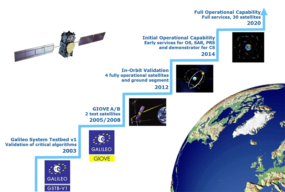
With four satellites in space, launched by pairs in October 2011 and October 2012 from French Guiana, the Galileo project is now successfully completing the In-Orbit Validation (IOV) phase. The Galileo space, ground, and user segments have been qualified through extensive on-ground and in-orbit tests, and operations, of a core satellite constellation and the associated ground segment.
The IOV architecture is being implemented as an integral part of the Full Operational Capability (FOC) — that is, the complete system, consisting of 30 satellites and a set of remote stations distributed worldwide to command and monitor the constellation and deliver the navigation and timing services to the users. Now that the overall design has been validated, the system will be progressively completed, in a staggered approach, to reach the FOC.
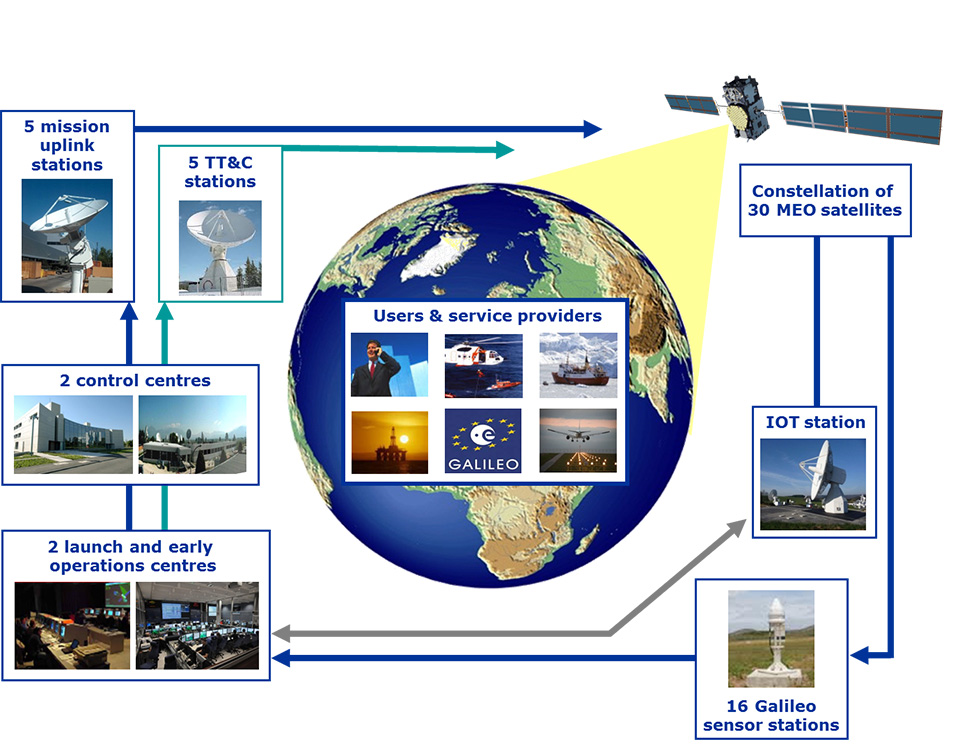
Figure 1. Galileo System Architecture.
Galileo System Overview
A joint initiative by the European Union and the European Space Agency, Galileo is one of the most ambitious and technologically advanced service-oriented systems being developed in Europe. A navigation satellite programme under civilian control, it is meant to provide positioning, navigation and timing signals on a global scale.
Galileo is based on a constellation of 30 satellites organized in a 24-satellite nominal constellation plus six active spares, a worldwide network of ground stations, and a number of Control Centres established in Europe to control the constellation, perform the navigation mission management, and monitor system performances
The Galileo programme is following an incremental path towards the deployment of the complete system and the exploitation of services.
The programme has been structured according to the main following phases:
IOV phase, to develop and validate in-orbit performance;
Initial Operational Capability (IOC) phase, including Early Services, to start delivering limited but guaranteed services, promoting chipset and receiver developments, downstream applications, and pilot projects by EU Member States;
FOC phase, to deploy in full the ground and space infrastructure as required for full operational capability;
Operations and service provision phase to operate the FOC infrastructure and provide navigation services over the system lifetime.
The definition, development, and IOV phases of Galileo were carried out by the European Space Agency (ESA) and co-funded by ESA and the European Union. The FOC phase is managed and fully funded by the European Union and supervised by the European Commission (EC). The EC and ESA have signed a delegation agreement under which ESA acts as design and procurement agent on behalf of the EC.
Galileo Early Services
ESA began navigation systems research and development in cooperation with the EC and the civil aviation community. The development strategy was conceived with two major pillars: the European Geostationary Navigation Overlay Service (EGNOS), a pan-European augmentation system, complementing GPS to deliver reliability information to users, and Galileo. Today, EGNOS is operational and certified, forming the basis of a wide range of general and safety-critical applications across the European continent.
Once Galileo becomes operational, a portfolio of navigation services will be offered by Galileo and EGNOS, based on varying user needs.
Galileo’s full operations and services will commence when all the satellites have been deployed, with the complete constellation of operational satellites and spares, supported by an extensive network of ground stations and local and regional service centres in their final configuration.
However, after a political decision by EC Vice-President Antonio Tajani, Galileo will start officially delivering Early Services as from the end of 2014.
Based on the space and ground configuration available in 2014, the following early services are targeted:
Open Service: delivery of stable E1, E5a, and E5b signals in space from a number of satellites in orbit, allowing users to perform ranging, E1 and E5a being interoperable with GPS;
Public Regulated Service: delivery of stable, secure E1 and E6 signals in space allowing pilot projects with EU Member States, to demonstrate PRS management capabilities;
Search and Rescue: guaranteed SAR forward link, which allows the detection and localization of COSPAS-SARSAT distress beacons;
Commercial Services: initial demonstration of precise positioning and authentication services with potential service providers.
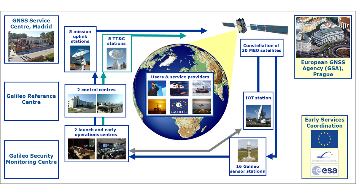
The Early Services phase is being prepared in close coordination by engineers from the EC, the European GNSS Agency (GSA), and ESA. The activities include the definition and procurement of infrastructural assets other than the Galileo core system, namely the GNSS Service Centre, which is the interface with user communities, and the Galileo Reference Centre to monitor service performance. Organizational and operational pillars of the Early Services provision are also defined with the public and industrial organizations involved and their governance and with all processes required for the delivery of services with all their dynamics. A service definition document defining expected service behavior and non-functional properties will be made available to all users through the GNSS Service Centre website.
Figure 3. Galileo Early Services Organisation.
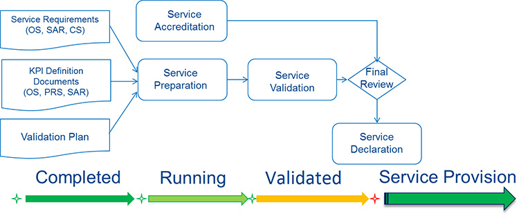
Service performance will be monitored by the Galileo Reference Centre over time by means of key performance indicators (KPIs), with target values and target ranges to be achieved over a certain time period. As far as processes are concerned, performance (quality, reliability, throughput), productivity (efficiency, effectiveness) and safeguards (security, safety) will be monitored over time.
Prior to official declaration of the Early Services, KPIs and technical performance will be monitored during a Service Validation Phase, aiming at a confirmation of the readiness of the overall service organization.
Figure 4. Service Validation Activities.
As part of the service validation, receiver and chipset manufacturers will be offered the possibility to test the performance of Galileo. The objective is to verify the market readiness and optimize Galileo use in a multi-constellation environment. A call for interest went out in July 2013, and leading mass-market chipset and professional receiver manufacturers have expressed interest in participating in the test campaign.
The tests have been adapted to the nature of the applications and markets targeted by each manufacturer. A first set of tests is planned at ESA, focusing on mass markets. These tests will evaluate assisted GNSS performance in difficult environments such as urban canyons. They will also address the need for a seamless switch from outdoor to indoor.
Another set of tests is planned at the European Union Joint Research Centre (JRC). They will respond to the needs of high-precision users, testing, for example, dual frequencies. Each test will be performed for different combinations of available GNSS to evaluate and demonstrate the added value of Galileo. The testing will start at the beginning of 2014 with laboratory tests based on simulated data and will continue during 2014 using real Galileo data.
Conclusion
Galileo will be an autonomous, global, European-controlled GNSS providing several guaranteed services to users equipped with Galileo-compatible receivers. From a value-chain viewpoint, Galileo is a system providing services meant to support or make feasible other service systems. Together with the introduction of state-of-the-art technology and of very complex system architecture, the delivery of sophisticated services is established on well-defined governance, operational, and regulatory bases.
After the successful completion of the IOV phase, Early Services will mark a new, substantial milestone towards the system’s full operational maturity and the exploitation of its capabilities and services.
Eric Chatre is the Head of Sector on Services and Exploitation for the EU Satellite Navigation Programmes in the European Commission, EC. Horst Faas is GNSS exploitation programme manager at the European GNSS Agency (GSA). Marco Lisi is GNSS services engineering manager at the European Space Agency.
Rohde & Schwarz extends the functionality of the R&S SMBV100A vector signal generator by adding BeiDou/Compass capability to its integrated GNSS simulator. With the R&S SMBV-K107 option, the GNSS simulator now covers the BeiDou standard as well as the GPS, Galileo and GLONASS satellite navigation systems.
The new option allows users to generate real-time scenarios with up to 24 BeiDou satellites. R&S SMBV-K107 supports all possible BeiDou orbits and can therefore even simulate satellites that are not yet in orbit. It also supports hybrid scenarios with GPS, Galileo or GLONASS satellites. A software update makes it easy to upgrade existing GNSS simulators for BeiDou. No hardware modifications are required.
The R&S SMBV100A permits users to quickly define their own satellite scenarios to test GNSS receivers under diverse conditions. A wide range of options are available for simulating realistic effects such as signal obscuration and multipath propagation. These scenarios can now be configured for BeiDou as well.
This inexpensive solution is one of the few on the market that does not require an external PC for testing receivers and components of satellite-based navigations systems, the company said. In addition to GNSS signals, the R&S SMBV100A can simulate mobile radio, wireless and radio standards, allowing users to test several functions with a single instrument.
The new R&S SMBV-K107 option is now available from Rohde & Schwarz.
Esri introduces the public beta version of its cloud-based Geotrigger Service that helps developers easily create location-aware apps for iPhone and Android without compromising battery life. The beta Geotrigger Service is available at no cost and feedback from developers will be used to shape the official release.
The Geotrigger Service allows apps built on the Esri location platform to quickly gather business intelligence such as where people are and when the app is used. Developers can also design apps that send messages to users when they arrive at or leave areas defined by a geofence.
“On the Esri location platform, we already offer a host of services for developers from geocoding and geoenrichment to routing maps. The Geotrigger Service boosts this offering with location-awareness and location-based alerts,” said Johan Herrlin, Esri’s senior business strategist.
Developers can use the Geotrigger Service for apps across all industries including:
·Retail and Loyalty: Engage customers with personalized content and deals the moment they enter a store.
·Real Estate: Send messages to prospective home buyers when their search criterion matches a nearby home.
·Energy Management: Use location to automatically manage power consumption at home or in the office.
·Tourism: Bring public attractions to life by informing tourists of interesting locations as they explore a city.
·Public Alerts: Notify citizens about events such as road closures or civic emergencies based on past locations.
Qualcomm Incorporated has announced that its subsidiary, Qualcomm Technologies, Inc., is enhancing location precision in smartphones and tablets initially in China with support for China’s BeiDou Satellite Navigation System.
Supporting the BeiDou constellation within Qualcomm IZat location solutions increases the number of satellites that Qualcomm-based devices can access to provide greater position location accuracy. Qualcomm is collaborating with Samsung to launch the first wave of BeiDou enhanced consumer smartphones, demonstrating the commitment of the companies to provide technology that delivers optimum performance for location-based services within China and globally.
Powered by the Qualcomm Snapdragon 800 processor (MSM8974), the Samsung Galaxy Note 3 (WCDMA 3G version SM-N9006 & TD-LTE 4G version SM-N9008V) uses the industry’s first, integrated tri-band location platform to provide more accurate and responsive location data to mobile users. It does so by concurrently processing signals from multiple satellite networks. Armed with this capability, users will have more enjoyable experiences using their location-based services, even in the most challenging of environments.
Leveraging Qualcomm IZat location solutions, Samsung will be able to deliver an optimal user experience with quick and accurate location information and services in China. Historically, this has been a challenge in some locations, especially in urban canyons, where devices may suffer from low visibility to satellites blocked by tall buildings that obstruct the signals. Bringing BeiDou-enabled phones to China means the Galaxy Note 3 has access to more satellites, which increases location accuracy. This ultimately improves customers’ pedestrian navigation, speeds local searches and enhances other location-based services.
Qualcomm’s mobile chipsets feature interoperability with existing constellations, which use tri-band hardware integration to deliver improved location capabilities in an optimal way, with enhanced accuracy, and with no additional increase in power consumption. In Snapdragon and Gobi™ chipsets, global positioning support is built into the modem and RF chips, enabling the location signals to be processed in the modem, instead of waking up the apps processor, thus saving power without sacrificing location accuracy.
“This industry-first implementation of BeiDou in a smartphone underscores Qualcomm’s leadership in the location industry. More than 3 billion devices which feature Qualcomm’s location technology have shipped to date and the introduction of BeiDou is the latest step to evolve our technology,” said Amir Faintuch, president, Qualcomm Atheros. “We see BeiDou’s support being an important factor for OEMs in China, and globally as well. With this new location enhancement, we believe our customers can bring greater differentiation with advanced performance, applications and services.”
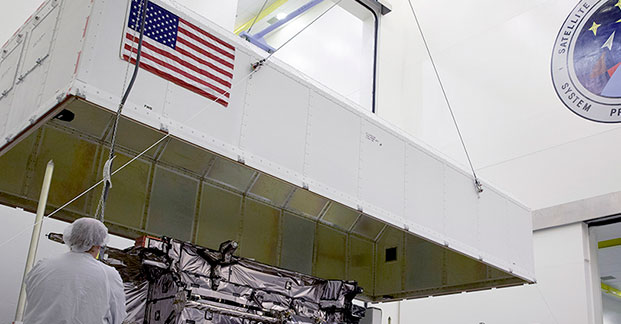
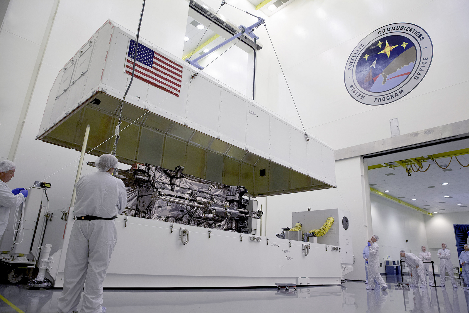
The GNST arrives at Cape Canaveral Air Force Station, Florida, in July.
The Lockheed Martin prototype of the next-generation GPS satellite, the GPS III, has proven that it is backwardly compatible with the existing GPS satellite constellation in orbit.
During tests that concluded on October 17, Lockheed Martin’s GPS III testbed successfully communicated via cross-links to Air Force simulators of the current GPS constellation in orbit. The current GPS constellation includes GPS IIR, GPS IIR-M, and GPS IIF satellites.
Testing also demonstrated the ability of an Air Force receiver to track navigation signals transmitted by the GPS III Nonflight Satellite Testbed (GNST). The GNST is a full-sized, functional satellite prototype at Cape Canaveral Air Force Station.
“These tests represent the first time when the GNST’s flight-like hardware has communicated with flight-like hardware from the rest of the GPS constellation and with a navigation receiver,” explained Paul Miller, Lockheed Martin’s director for GPS III Development. “This provides early confidence in the GPS III’s design to bring advanced capabilities to our nation, while also being backward-compatible.”
Lockheed Martin is under contract to produce the first four GPS III satellites (SV 01-04), and has received advanced procurement funding for long-lead components for the fifth, sixth, seventh, and eighth satellites (SV 05-08). The first flight-ready GPS III satellite is expected to arrive at Cape Canaveral in 2014, for launch by the Air Force in 2015.
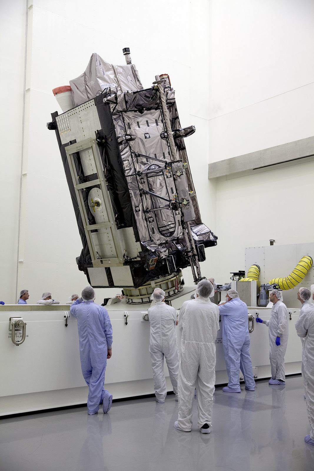
Testing took place with the GNST — a test version of the GPS III — at Cape Canaveral.
GPS III, a critically important program for the Air Force, will replace aging GPS satellites in orbit while improving capability to meet the evolving demands of military, commercial and civilian users. GPS III satellites will deliver three times better accuracy; provide up to eight times more powerful anti-jamming capabilities; and include enhancements to extend spacecraft life 25 percent further than the prior GPS block. It will be the first GPS satellite with a new L1C civil signal designed to make it interoperable with other international global navigation satellite systems.
An innovative investment by the Air Force under the original GPS III development contract, the GNST has helped to identify and resolve development issues prior to integration and test of the first GPS III flight space vehicle (SV 01). Following the Air Force’s rigorous “back-to-basics” acquisition approach, the GNST has gone through the development, test, and production process for the GPS III program first, significantly reducing risk for the flight vehicles, improving production predictability, increasing mission assurance, and lowering overall program costs.
The GNST arrived at the Cape on July 19 to test facilities and pre-launch processes in advance of the arrival of the first flight satellite. On August 30, the GNST successfully established remote connectivity and communicated with the GPS Next Generation Operational Control System (OCX), being developed by Raytheon.
Before shipment to the Cape, the GNST completed a series of high-fidelity activities to pathfind the integration, test and environmental checkout that all production GPS III satellites undergo at Lockheed Martin’s GPS III Processing Facility (GPF) in Denver, Colo.
The GPS III team is led by the Global Positioning Systems Directorate at the U.S. Air Force Space and Missile Systems Center. Lockheed Martin is the GPS III prime contractor, with teammates including ITT Exelis, General Dynamics, Infinity Systems Engineering, Honeywell, ATK, and other subcontractors. Air Force Space Command’s 2nd Space Operations Squadron, based at Schriever Air Force Base, Colo., manages and operates the GPS constellation for both civil and military users.
UrsaNav’s President, Charles Schue, shown accepting the transmitter from Nautel’s President, Peter Conlon.
After extensive Final Acceptance Testing at Nautel’s Hackett’s Cove, NS facility, UrsaNav has accepted delivery of the first production NL40 Loran-C and Enhanced Loran (eLoran) transmitter. This seventh-generation Loran transmitter technology is the culmination of more than six years of collaborative development between the two companies.
The transmitter successfully met or exceeded all of the requirements of the U.S. Coast Guard “Specification of the Transmitted Loran-C Signal.” Testing was conducted into a simulated antenna matching the characteristics of a U.S. Coast Guard “standard” 625-foot top-loaded monopole. The NL-Series transmitters are capable of transmitting Loran-C, eLoran, Chayka, and eChayka in any combination at power levels exceeding one megawatt. They are qualified for today, and prepared for tomorrow, UrsaNav said.
“Resilient PNT begins with complementary technologies, layered one upon the other in such a way that the user is ensured improved continuity of operations over a sole-source solution,” said UrsaNav President Charles Schue. “eLoran is the terrestrial co-primary complement to GNSS, and our technology makes eLoran the most economical, efficient, and wide-area alternative when GNSS is not available.”
On November 7, the FAA released a new roadmap for the “Integration of Civil Unmanned Aircraft Systems (UAS) in the National Airspace System (NAS)” — which it is hoped will provide improved guidance for those extremely interested operators, manufacturers, systems suppliers and those with pending civilian applications of unmanned aircraft.
The forward to the Roadmap by FAA Administrator Michael Huerta says,
‘This roadmap outlines the actions and considerations needed to enable UAS integration into the NAS. The roadmap also aligns proposed FAA actions with Congressional mandates from the FAA Modernization and Reform Act of 2012. This plan also provides goals, metrics, and target dates for the FAA and its government and industry partners to use in planning key activities for UAS integration.”
The FAA, acting through the Unmanned Aircraft Systems Integration Office, aims to enable the integration of UAS safely and efficiently into the NAS. To do so, the FAA is working with stakeholders — manufacturers, vendors, industry trade associations, technical standards organizations, academic institutions, research and development centers, governmental agencies, and other regulators.
The premise is that UAS will be allowed to operate in the NAS, but in so doing cannot reduce existing capacity or decrease safety, cannot negatively impact current operators/operations, and cannot increase the risk to airspace users or people or property on the ground — any more than the integration of other new or novel technology. While progress has so far been significant, many challenges and opportunities apparently lie ahead.
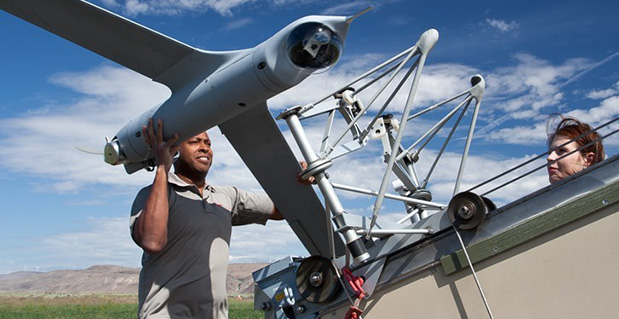
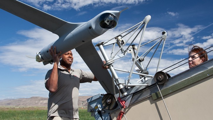
Up to the recent Restricted Type Certification of a couple of unmanned aircraft systems by FAA — namely the Boeing/Insitu Scan Eagle and the AeroVironment’s Puma AE — operators have been and still are required to apply to the FAA for individual Certificates of Authorization (CoA) for each and every U.S. application of UAS. The FAA Roadmap is intended to provide an initial estimate of timing and to list tasks and considerations that will ultimately enable UAS integration into the NAS for the planning purposes of the UAS community.
Boeing/Insitu Scan Eagle loaded for launch.
Commercial operations that the FAA envisages include:
security awareness;
disaster response, including search and support to rescuers;
communications and broadcast, including news/sporting event coverage;
cargo transport;
spectral and thermal analysis;
critical infrastructure monitoring, including power facilities, ports, and pipelines;
commercial photography, aerial mapping and charting, and advertising.
Other commercial and public applications that the FAA might also want to add to the increasing demand for airspace access include:
crop monitoring;
precision surveying and GIS;
wildlife monitoring;
(ground) traffic monitoring and control;
firefighting support;
police services;
many, many more applications which will emerge rapidly once regulations permit ready access to airspace.
Of course, the FAA controls an ever increasingly complex airspace to which certified manned aircraft already have regulated access – it’s only fitting that existing safety and commercial use be primarily maintained and in no way compromised. Successful demonstration of UAS to achieve demanding communications, navigation, and surveillance performance will be essential.
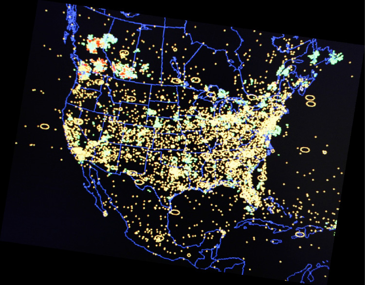
U.S. National Airspace System.
The Roadmap quotes the International Civil Aviation Organization (ICAO) Circular 328, “Unmanned Aircraft Systems (UAS) Circular”:
“A number of Civil Aviation Authorities (CAA) have adopted the policy that UAS must meet the equivalent levels of safety as manned aircraft… In general, UAS should be operated in accordance with the rule governing the flight of manned aircraft and meet equipment requirements applicable to the class of airspace within which they intend to operate…To safely integrate UAS in non-segregated airspace, the UAS must act and respond as manned aircraft do. Air Traffic, Airspace and Airport standards should not be significantly changed. The UAS must be able to comply with existing provisions to the greatest extent possible.”
Another significant FAA statement:
“Except for some special cases, such as small UAS (sUAS) with very limited operational range, all UAS will require design and airworthiness certification to fly civil operations in the NAS.”
So, having set the tone that UAS will have to grow up in a major way to become equivalent to existing manned aircraft and to comply with virtually the same rules, the Roadmap goes on to provide much more detail of what will be required.
The FAA is working on UAS regulations — this is not really a big surprise. It would seem that there is significant effort underway to get rules in place, detailed rules which not everyone in the UAS industry will welcome. One scenario is that the huge range of UAS suppliers that we see regularly at the AUVSI annual convention/exhibit could be slimmed down if the market indeed transitions to commercial operations from the current level of military applications, and only the big companies who can afford to comply will remain. Reduced competition usually means increased costs for users, so this may not sit well with the market.
Then there are more difficulties in adapting existing airborne regulations for commercial aircraft to UAS and UAS applications. An example is given of regulations for commercial transport cockpit doors — what’s a “cockpit” when you think of UAS, and where’s the “door” for a ground-based control system in a mobile trailer, or a handheld iPad flying a small quad-rotor air vehicle? (Maybe a different thought process is required here.)
Then the air-traffic control system has to absorb flight of unmanned aircraft in an already overcrowded route network system. Of course, only some UAS operations will be intertwined with regular commercial transport air traffic, but there are huge numbers of “less-disciplined” General Aviation fixed-wing and rotor aircraft with which UAS are bound to interact. So ATC has to understand, control and regulate that interaction. Surely these are common-sense statements which most people would support?
Major technology challenges are anticipated due to the absence of an on-board pilot.
“Removing the pilot from the aircraft creates a series of performance considerations between manned and unmanned aircraft that need to be fully researched and understood to determine acceptability and potential impact on safe operations in the NAS.”
There’s that dreaded word — “researched.” For anyone in the business of selling UAS or UAS systems, including GNSS-based guidance systems, the need for potentially prolonged research may spell death for a nascent business, currently bursting with potential!
Development of Sense and Avoid and Control and Communications (C2) systems with adequate performance are seen as the principle challenges, so a phased introduction of UAS is anticipated while these core systems are fielded and matured over a lengthy period. The current CoA approach is termed “accommodation,” while evolution is expected towards more compliant vehicles and systems during the integration phase — ultimately, with fewer and fewer CoAs. Although the Roadmap talked about “broad timelines,” this key section doesn’t try to predict how long this all might take.
The FAA summarizes the accommodation phase as:
Accommodation of UAS in the NAS through evaluation and improvement of safety mitigations.
Work with industry and the Aviation Rulemaking Committee (ARC) to review the operational, pilot, and airworthiness regulations.
Development of required standards to support technological solutions to identified operational gaps (Minimum Operational Performance Standards [MOPS]).
Safety case validation for UAS operations in NAS — collect/analyze operational and safety data.
Robust research, modeling, and simulation for UAS Sense and Avoid, C2, and human factors.
The Integration phase is characterized by adoption of FAA regulations through certification of compliant UAS and UAS systems — the balance between CoA operations and regular operations in the NAS shifts toward more compliant, and presumably more unrestricted, access within FAA regulations. With UAS and UAS systems achieving airworthiness certificates, and trained and certificated UAS pilots filing regular flight plans for UAS operations, integration moves towards adoption. “All UAS must file and fly an IFR flight plan.” Lessons learned in earlier phases are moved into updated regulations and incorporated into equipment capabilities, and certificated UAS get increasingly better access to the airspace they require.
FAA also makes mention that in the integration phase, the six proposed UAS FAA test ranges will be selected. This has been in the works for considerable time. The assessment of proposals and award of contracts had initially been delayed on the basis of privacy questions, but these now appear to have been adequately addressed to allow these key parts of the UAS integration program to move ahead. A principle objective of the test ranges is to help provide a verification mechanism for safe operations before unmanned aircraft are integrated into the NAS. Tasks envisaged include development and proving of:
manned-unmanned operations,
certification standards and air traffic requirements,
coordination and leveraging of National Aeronautics and Space Administration (NASA) and DoD resources,
civil and public unmanned aircraft systems,
coordination with NextGen (a major NAS update program currently being undertaken by FAA).
Integration will have been successfully established when new operational rules and associated standards, policies, and procedures have been established for small UAS and other UAS, and C2 link standards have been defined for integrity, latency, and continuity. FAA will also need to have accepted Minimum Aircraft System Performance Specifications (MASPS) to enable development of detailed MOPS and the FAA should have published policy and operational guidance to define acceptable methods to comply with operational rules in accordance with an acceptable UAS certification basis for each applicant, along with flight-crew training and certification standards.
For the final “Evolutionary” phase of adoption of UAS, it’s expected that there will be seamless operations of certified UAS and crew members in the evolving NAS; FAA will have published Type Standard Orders (TSOs) based on system level MOPS; and certified Sense and Avoid algorithms will be available for collision avoidance and self-separation that are interoperable with evolving NextGen ATC systems and manned collision avoidance systems.
Quite a long list of extensive requirements to meet for a new industry that, so far, has been largely unregulated and has, so far, been used to providing rapid military/governmental solutions that prove themselves operationally over time. More empirical development to satisfy specific operational needs than compliance to published regulations. This isn’t exactly a sea-state change for the industry as it sits today, but perhaps rather a shift into another dimension.
To even get itself onto this road, let alone follow this extensive 74-page roadmap, the UAS industry may have to completely re-invent itself. But with military sales declining, the funding to take on even the simplest of these requirements may be drying up. The tendency for operators may be to try to cling to the CoA system indefinitely and just live with the hassle of applying for FAA authorization each time. FAA’s seeding of commercial applications using Restricted Type Certification of existing platforms that use existing uncertified systems and payloads may also be a way out for some time. If the Scan Eagle can gain limited access to take on commercial, paying applications because it has +800,000 proven military flight hours, eventually other UAS may also creep into some sort of equivalent eligibility. And if we manage to operate safely without major headlines, the FAA may relent in some of its extensive requirements.
Then again, the FAA just published a rather extensive roadmap, with separate backup, which says it has other ideas in mind….
I asked a couple of industry experts what they thought of the Roadmap. One comment was, “To me the real challenge is flexibility in the plan such that it will be a reasonable process to adapt to changes based on findings, experiences as this goes forward.” I agree, and believe that the FAA has gone to some length to make it clear that this is the first issue of the Roadmap, that there will be updates as more is learned. The whole process is one of learning from what has gone before in earlier stages.
Please join us Thursday, November 21, for a GPS World webcast on Unmanned Aircraft Navigation. We’ll have a number of industry leaders who will present their companies’ experience and capabilities in navigation for UAS, along with how they see this exciting market segment progressing, and how the FAA’s plans could impact their vision of the future for UAS navigation systems suppliers. Register today for free.
Phones sold in Russia will have to use GLONASS or GLONASS + GPS as of 2014, according to a report from the Voice of Russia. Phones with only GPS will be illegal in Russia, and any mobile devices imported will have to support GLONASS.
A new bill claims that in order to guarantee stable operation of a unified telecom network in Russia regardless of conditions, it’s necessary that the satnav system used be the one controlled by the Russian Federation. New requirements for mobile devices with satellite navigation capabilities are expected to follow.
The authors of the bill note that after the bill is adopted, its requirements will cover all manufacturers and vendors of cellphones, making it impossible to sell a mobile device without GLONASS support.
The Telecom Ministry and industry watchdog Roskomnadzor will oversee the changes.
On August 30, QinetiQ and Rockwell Collins demonstrated the first joint satellite navigation positioning using live signals from the encrypted governmental services from the U.S. Department of Defense (DOD) GPS Precise Positioning Service (GPS-PPS) and the new European Galileo Public Regulated Service (PRS). The signals on GPS L1 and L2, together with Galileo PRS L1A and E6A, were processed and combined to form multi-frequency, multi-constellation position fixes.
Positioning, navigation and timing (PNT) services provided by GNSS, such as GPS and the forthcoming Galileo system, are essential to underpinning both commercial and economic activity (the EC estimates 6-7% of the developed world’s GDP) and the delivery of governmental responsibilities including the safety and security of citizens.
GNSS systems such as GPS and Galileo make use of very low power signals and are subject to inadvertent interference, deliberate jamming and spoofing (where an attacker generates a false signal masquerading as a valid one to mislead a user receiver). Attacks on GNSS may range from low-level criminal nuisance (a delivery driver stopping their employer tracking them), enabling theft of high-value vehicles fitted with trackers, through to state-sponsored attacks. This is potentially a significant concern for a wide range of governmental users including law enforcement, security and emergency services, critical national infrastructure, transport and defense users. The use of multiple independent, secured navigation services provides significant improvements to navigation robustness and, along with other measures, offers substantial counters to these threats.
“This has been our first opportunity to explore how secured navigation services on GPS and Galileo can be used together to provide users with critical reliance on PNT with robust and continuous navigation services,” Nigel Davies, Head of QinetiQ’s Secured Navigation Group said. “QinetiQ is proud to be a key, long-term contributor to the Galileo Programme, having been working closely with the European Space Agency (ESA), the European GNSS Agency (GSA), European industrial partners and European Member States since 2003. QinetiQ and Rockwell Collins wish to thank ESA, the EC and GSA for support in accessing Galileo, as well as the UK Space Agency, UK Satellite Applications Catapult and the UK MOD for their support.”
Esri’s releases new versions of Collector for ArcGIS and Operations Dashboard for ArcGIS include display, configuration, and workflow enhancements that improve field data collection and enterprise oversight. Both apps are available at no cost to Portal for ArcGIS customers and ArcGIS Online subscribers.
According to the announcement, Collector for ArcGIS is a configurable field data collection app for iOS and Android. The new version of Collector includes support for iPad and Android tablets. Templates, selection results, directions, and more, can now be viewed alongside the map on mobile devices with larger screen real estate. The updated Collector app also expands the types of data that can be collected. It now allows the input of GIS features of all primary shape types (e.g., points, lines, and polygons). The app also gives you the ability to view and control GPS accuracy when capturing features so you can stream positions from the GPS as you move.
Data capture often involves recording repetitive information at different locations and/or multiple features of different types at the same location. To reduce that manual repetition, Esri introduced a continuous collect mode that allows you to copy the location or attributes of the last collected feature.
Esri reports that they also updated Operations Dashboard for ArcGIS, that provides a common operational picture for monitoring, tracking, and reporting events to people within your organization. The new version of Operations Dashboard improves the way you work with data. Because you can potentially use Operations Dashboard to view extensive lists of information, Esri added the ability to search within lists to quickly find what you need. You can now see charts, graphs, custom text, and photo attachments within the pop-up windows. You can also filter the map and all widgets using relative time, such as within the last hour or month, or after a specific date. This helps you monitor and analyze data that changes rapidly over time.
Operations Dashboard for ArcGIS now fully supports Portal for ArcGIS as well as ArcGIS Online. A new configuration utility is available to Portal customers, making it easy to sign in and deploy the Operations Dashboard app on-premises.
Collector for ArcGIS can be downloaded from the Apple App Store and Google Play. Operations Dashboard is available through ArcGIS Online. Portal for ArcGIS users can access the Operations Dashboard app from the Customer Care portal.
The U.S. Department of Transportation’s Federal Aviation Administration (FAA) released its first annual Roadmap outlining efforts needed to safely integrate unmanned aircraft systems (UAS) into the nation’s airspace. The Roadmap addresses current and future policies, regulations, technologies and procedures that will be required as demand moves the country from today’s limited accommodation of UAS operations to the extensive integration of UAS into the NextGen aviation system in the future.
“Government and industry face significant challenges as unmanned aircraft move into the aviation mainstream,” said U.S. Transportation Secretary Anthony Foxx. “This Roadmap is an important step forward that will help stakeholders understand the operational goals and safety issues we need to consider when planning for the future of our airspace.”
According to the announcement, the Roadmap outlines the FAA’s approach to ensuring that widespread UAS use is safe, from the perspective of accommodation, integration, and evolution. The FAA’s main goal for integration is to establish requirements that UAS operators will have to meet in order to increase access to airspace over the next five to 10 years. The Roadmap discusses items such as new or revised regulations, policies, procedures, guidance material, training and understanding of systems and operations to support routine UAS operations.
“The FAA is committed to safe, efficient and timely integration of UAS into our airspace,” said FAA Administrator Michael Huerta. “We are dedicated to moving this exciting new technology along as quickly and safely as possible.”
The FAA reports that the Roadmap also addresses the evolution of UAS operations once all requirements and standards are in place and are routinely updated to support UAS operations as the National Airspace System evolves over time. The document stresses that the UAS community must understand the system is not static, and that many improvements are planned for the airspace system over the next 15 years.
The FAA plans to select six UAS test sites to begin work on safely integrating UAS into the airspace. These congressionally-mandated test sites will conduct critical research into how best to safely integrate UAS systems into the national airspace over the next several years and what certification and navigation requirements will need to be established.
The use of UAS, both at the designated test sites and in the national airspace generally, raises the issue of privacy and protection of civil liberties. In February, the FAA asked for public comments specifically on the draft privacy requirements for the six test sites. Today, the agency sent a final privacy policy to the FederalRegister that requires test site operators to comply with federal, state, and other laws on individual privacy protection, to have a publicly available privacy plan and a written plan for data use and retention, and to conduct an annual review of privacy practices that allows for public comment. Information about the test site selection process and final test site privacy policy is available at: http://www.faa.gov/about/initiatives/uas/
For the next several years, the FAA will continue to use special mitigations and procedures to safely accommodate limited UAS access to the nation’s airspace on a case-by-case basis. The Roadmap notes that this case-by-case accommodation will decline significantly as integration begins and expands, but will continue to be a practical way to allow flights by some UAS operators in certain circumstances.
In addition to the FAA’s Roadmap, as required in the 2012 FAA Reauthorization, the Joint Planning and Development Office (JPDO) has developed a comprehensive plan to safely accelerate the integration of civil UAS into the national airspace system.. That plan details a multi-agency approach to safe and timely UAS integration and coordination with the NextGen shift to satellite-based technologies and new procedures.