Category: GNSS

  • Baykar demos swarm UAVs without GNSS

    Baykar demos swarm UAVs without GNSS

    Turkish UAV maker Baykar demonstrated its next-generation Kamikaze UAV K2 and Sivrisinek (Mosquito) loitering munition, showcasing AI-supported swarm autonomy, GNSS-independent navigation, automatic target detection, and strike capabilities during a demonstration held at the Keşan Flight Training and Test Center.

    The K2 Kamikaze UAV and the Sivrisinek loitering munition will make their public debut at SAHA 2026, which takes place in Istanbul May 5-9.

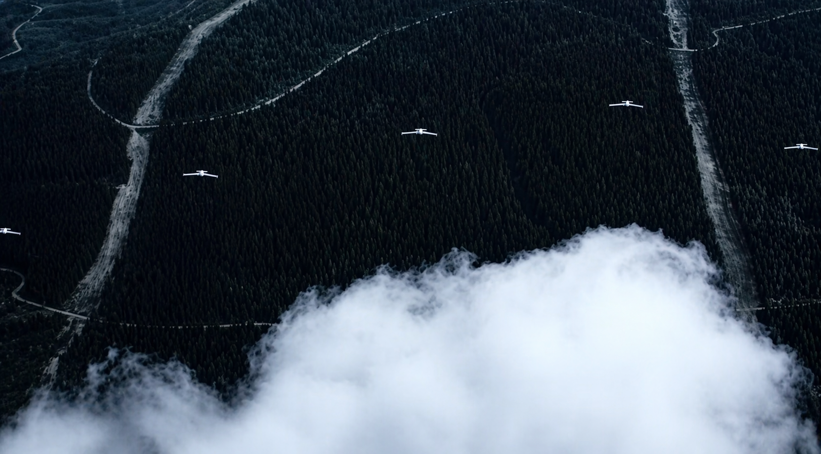
    The April 17 demonstration opened with the sequential takeoffs of five K2 Kamikaze UAVs within five minutes. Once airborne, the platforms conducted patrol flights in “right echelon,” “line,” “V,” and “Turan” formations.

    Ten Sivrisinek loitering munitions — a new platform developed by Baykar — then joined the operation, forming a swarm beneath the K2 Kamikaze UAVs. The Bayraktar TB2, TB3, and AKINCI UCAVs accompanied the swarm flight, recording the operation from the air.


    Credit: Baykar


    AI-supported visual navigation
    Among the key technical highlights of the demonstration were the solutions developed to counter electronic warfare environments. Using AI-supported visual navigation software, the platforms demonstrated the capability to perform positioning and navigation independently of GNSS.

    Having successfully showcased autonomous navigation in a GNSS-denied environment, the K2 and Sivrisinek Kamikaze UAVs also demonstrated AI-supported automatic target detection and automatic strike capabilities.

    As part of the demonstration, a fleet of Sivrisinek loitering munitions executed a dive on the designated coordinates. A K2 Kamikaze UAV then broke off from the swarm and performed a high-speed dive on the designated coordinates, conducting a pass. In the final phase of the demonstration, a swarm group composed of 18 unmanned aerial vehicles across different classes — 5 K2s, 10 Sivrisinek, 1 Bayraktar TB2, 1 TB3, and 1 AKINCI — came together in a “V” formation to salute the delegation observing the flight.

    Developed by Baykar, the next-generation Sivrisinek loitering munition raises operational depth to a range exceeding 1,000 kilometers. Capable of uninterrupted communication within the swarm through AI support, Sivrisinek platforms can instantly share detected targets with one another.

    Performing its missions through AI-based visual positioning even in the most challenging environments — including areas where GNSS signals are unavailable or subject to intensive jamming — Sivrisinek stands out in strategic missions to be conducted on the battlefield thanks to its high autonomy capability.

  • Rohde & Schwarz to highlight UAV-based navigation analyzer at IFIS 2026

    Rohde & Schwarz to highlight UAV-based navigation analyzer at IFIS 2026

    The 23rd International Flight Inspection Symposium (IFIS) will gather experts in San Salvador May 4-8. There, Rohde & Schwarz will demonstrate its test and measurement solutions for ground-based navigation aids. The exhibits address the rising traffic volumes and stricter safety requirements.

    Rohde & Schwarz will take part in the conference’s technical sessions with a presentation on “Challenges for UAV Operations in RF Dense Aerodrome Environments.”

    The aviation sector today faces increasing air traffic density, rapid technological advancements and heightened security concerns, the company explained. Operators need test equipment that delivers laboratory level precision while tolerating the harsh environment of an airport runway or a remote navigation site.

    Among the exhibits at the Rohde & Schwarz booth is the R&S EVSD1000 VHF/UHF Nav/Drone Analyzer, designed to conduct GBAS, ILS and VOR measurements in line with ICAO Doc 8071 and ICAO Annex 10. The receiver delivers laboratory precision, supports an air to ground Wi‑Fi datalink and gapless measurements with improved location accuracy during flight inspections. Customers benefit from a device that can be mounted on a drone, reducing the need for manned flights and lowering operational expenses.

    Rohde & Schwarz gives airlines, airport operators and navigation service providers a reliable way to certify and maintain ground‑based aids under today’s demanding conditions. By combining high measurement accuracy, easy operation and durability, Rohde & Schwarz aims to help the industry keep pace with growth.

  • Lockheed Martin launches GPS III satellite

    Lockheed Martin launches GPS III satellite

    The U.S. Space Force and Lockheed Martin launched the GPS III Space Vehicle 10 (SV10) on April 21, marking the final satellite in the GPS III series and bringing the GPS constellation to its largest size to date.

    Signal acquisition was achieved shortly after launch. The spacecraft is being managed at Lockheed Martin’s Denver-based launch and checkout operations center while it undergoes initial testing before integration into the operational network.

    SV10 includes enhancements designed to improve the accuracy and resiliency of the constellation. Among its payloads is an optical crosslink demonstration designed to test direct satellite-to-satellite communication in orbit, a capability intended to strengthen system robustness.

    The launch represents the fourth consecutive GPS mission conducted on an accelerated schedule.

    GPS III satellites provide improved performance over earlier generations, including increased positioning accuracy, stronger resistance to jamming, and the addition of secure M-code signals for military users. The constellation supports positioning, navigation and timing (PNT) services for military, civil and commercial applications worldwide.

    SV10 also carries a demonstration digital rubidium atomic frequency standard, an advanced clock designed to improve onboard timekeeping precision.

    The deployment of SV10 concludes the GPS III series and precedes the next-generation GPS IIIF satellites. The upcoming series is expected to introduce additional capabilities, including enhanced anti-jamming features such as Regional Military Protection.

    More than 30 GPS satellites are currently in orbit, providing global PNT services to billions of users across defense, infrastructure and commercial sectors.

  • u-blox explores how Celeste LEO PNT complements GNSS for mass market

    u-blox explores how Celeste LEO PNT complements GNSS for mass market

    Low-Earth-orbit signals add increased signal strength, geometry diversity and robustness to GNSS.

    U-blox, a global leader in positioning and short-range communication technologies for automotive, industrial and consumer markets, is exploring how the introduction of low-Earth-orbit (LEO) signals can complement and integrate with existing GNSS to support mass-market positioning solutions.

    The announcement comes following the launch of the European Space Agency’s (ESA) first Celeste LEO-PNT demonstration satellites (IOD-1 and IOD-2) on 28 March 2026, marking a key milestone in bringing LEO-based signals into the operational positioning environment and ESA’s first step toward extending satellite navigation into low Earth orbit.

    As the positioning ecosystem evolves, LEO-based signals are emerging as a complementary layer to established GNSS. Designed to augment systems such as Galileo, LEO satellites introduce a new building block characterized by lower orbital altitude, increased signal strength, and rapidly changing satellite geometry. GNSS remains the foundation of global positioning, delivering proven coverage and consistency at scale.

    This evolution is not only about additional signals, but about how positioning systems behave over time. The dynamic geometry of LEO satellites introduces new system characteristics that influence convergence speed, robustness, and performance in challenging signal conditions.

    Under its Navigation Innovation and Support Program (NAVISP) Element 2 (EL2) project, co-funded by ESA, u-blox is conducting a technical assessment of the role of LEO signals in multi-layer positioning architectures. This work forms part of a broader effort to bring LEO-PNT capabilities to mass-market GNSS receivers, combining emerging LEO signals with established GNSS systems.

    This includes early integration work on u-blox’s X20 GNSS platform, exploring how different signal types and frequency bands can be optimally incorporated into u-blox’s positioning systems. The scope of work includes:

    • Observation and characterization of emerging LEO signal transmissions
    • Analysis of interactions between LEO signals and GNSS measurements
    • Evaluation of the impact of dynamic satellite geometry on positioning performance
    • Exploring different system-level approaches for integrating LEO signals into future platforms 

    “U-blox is committed to advancing positioning technologies through focused research and collaboration,” said Jani Käppi, head of technology positioning at u-blox. “Our work within the ESA NAVISP framework allows us to better understand how emerging signal sources can complement GNSS and contribute to robust and reliable positioning performance.”

    U-blox expects to contribute to the development of the new LEO satellite ecosystem with significant innovation in the positioning solution, collaborating with key partners like ESA.

    The Celeste initiative

    The Celeste mission is ESA’s initiative for LEO-PNT (Low Earth Orbit Positioning Navigation and Timing) and is in its in-orbit demonstration phase. This first phase features a demonstration constellation of 11 satellites that will fly in low Earth orbit to test innovative signals across various frequency bands. Its goal is to advance satellite navigation concepts for resilient positioning and timing services.

    The Celeste in-orbit demonstration phase was approved at ESA’s Council at Ministerial Level of 2022. The fleet is being developed through two parallel contracts respectively led by GMV in Spain with OHB in Germany as core partner, and by Thales Alenia France as prime and Thales Alenia Italy as space segment responsible and involving over 50 entities from more than 14 countries.

    Celeste was further supported in ESA’s Council at Ministerial Level of 2025 (CM25), towards the implementation of the next phase: the LEO-PNT In-Orbit Preparatory phase.

    Celeste also contributes to one of the three core pillars of ESA’s new European Resilience from Space (ERS) initiative, endorsed at CM25. ERS addresses critical security and resilience needs for Member States while laying the groundwork for future European strategic space capabilities.

  • Beyond Gravity delivers key payload components for ESA’s Celeste

    Beyond Gravity delivers key payload components for ESA’s Celeste

    Beyond Gravity has delivered key payload components for the ESA’s Celeste project aimed at making existing satellite navigation systems more accurate and resilient. The first demo satellites were launched into space on March 28. Beyond Gravity wants to further extend its payload offerings.

    The European Space Agency (ESA) is embarking on a demonstration mission of 11 satellites in orbit to test and demonstrate the benefits of an additional layer of PNT (positioning, navigation and timing) in low Earth orbit. This will further improve the accuracy and responsiveness of Europe’s satellite navigation system, even during jamming and spoofing attacks. Celeste demonstrates how this additional layer can complement the resilience, security and precision of the European navigation system Galileo.

    The first two demonstration satellites of the new Celeste navigation mission were launched into space on March 28.

    “Key electronics for the Celeste satellite payload are provided by Beyond Gravity,” said Oliver Grassmann, chief operating officer at Beyond Gravity. “Expanding our payload capabilities is a top priority, as we continue to deliver high‑performance solutions for diverse missions — including radio occultation, reflectometry, electronic signal intelligence, and positioning, navigation, and timing.”

    Kurt Kober, vice president, Electronic Solutions at Beyond Gravity, highlights the company’s key contributions to Celeste. “We play an important role in this mission and supply cutting-edge technology for digital signal generation and the clock for the satellite instruments,” Kober said. “These components ensure high reliability of the navigation signals as well as time accuracy and stability.”

    Apart from the payload components, the company also supplied highly sensitive antennas. ESA has chosen Beyond Gravity as a key payload partner for Celeste alongside the Spanish space company GMV (prime contractor) and OHB in Germany.

    Making Galileo more secure

    The new Celeste navigation satellites in low Earth orbit will demonstrate how an additional layer in a low-earth orbit around 500 km could complement the larger Galileo navigation satellites at an altitude of around 23,000 kilometers and make them more secure. This new satellite mission is known as Celeste, ESA’s first initiative in Low Earth Orbit PNT (LEO-PNT).

    The in-orbit demonstrator phase for Celeste is being executed by two European consortiums in parallel and will comprise a total of 11 satellites plus one spare. GMV, as one of the prime contractors, is responsible for the complete end-to-end mission, including system definition and design, the space and ground segments, the user segment and operations, for 6 of the demonstrator satellites.

    Importance of satellite payloads

    The payload comprises those elements of a satellite that perform its actual task, in the case of Celeste the creation and transmission of navigation signals. “We have already delivered important satellite instruments, like our radio occultation weather instruments, and a reflectometer payload,” Kober said. “We also supplied payload elements in the field of signal generation for the European satellite navigation system Galileo. This expertise has been incorporated into the Celeste project.”

    Kober sees satellite payloads as an important area for future business. “We want to play a greater role in this core area of satellites, the payload.”

    Modular payload solution

    With its FoX electronics platform, Beyond Gravity offers a flexible and modular solution that can host different payloads. Examples for such possible payloads include electronic signal intelligence (ELINT), which can be used for detecting and characterizing radar signals, or a PNT (positioning, navigation, timing) payload.

    Other possible payloads from Beyond Gravity are its radio occultation and reflectometry instruments as well as high-resolution earth observation images (optical payload from a third-party supplier).

    The FoX electronics platform, together with the payloads selected for the customer, can be easily integrated into Beyond Gravity’s satellite platform (multi-purpose platform), which successfully passed its Preliminary Design Review and is now undergoing intensive tests.

  • ESA’s Celeste IOD-1 satellite transmits first navigation signal

    ESA’s Celeste IOD-1 satellite transmits first navigation signal

    Celeste will test a complementary low-Earth-orbit layer for Galileo for more robust and accurate navigation.

    At 10:38 CET on April 8, the Celeste IOD-1 satellite, developed by GMV and Alén Space under the European Space Agency’s (ESA) Celeste In-Orbit Demonstrator (IOD) program, successfully transmitted its navigation signal for the first time.

    The reception of the signal from the Celeste IOD-1 satellite, confirmed by ESA teams at ESTEC, marks a key milestone for the program as it confirms the satellite’s successful commissioning in orbit. The signal was also received at GMV’s monitoring station in Lisbon.

    The first two IOD satellites of the Celeste program — built by GMV and Thales Alenia Space, respectively — were launched March 28 at 10:14 CET from Rocket Lab’s Launch Complex 1 in Mahia, New Zealand. Separation from the launch vehicle took place one hour later, marking the start of the initial operations phase (LEOP) and commissioning, carried out by GMV for the IOD-1 satellite from the mission control center in Tres Cantos.

    Next-generation LEO navigation

    Celeste is ESA’s strategic program to demonstrate the benefits of an additional low Earth orbit (LEO) navigation layer that complements Galileo and EGNOS, with the goal of improving the accuracy, resilience and security of positioning, navigation and timing (PNT) services in Europe.

    The in-orbit demonstrator (IOD) represents the program’s first phase and will validate key LEO-PNT technologies in flight ahead of potential future operational deployment.

    The Celeste IOD phase is being carried out in parallel by two European consortia and will include a total of 11 satellites plus one in-orbit spare. As one of the prime contractors, GMV is responsible for the end-to-end mission for six of the demonstrator satellites, including system definition and design, the space and ground segments, the user segment, and operations.

    Celeste program beginnings

    The Celeste program began with two demonstrator satellites, IOD-1 and IOD-2, aimed at securing registered frequency allocations and testing representative navigation signals through the end of the year. The mission will demonstrate precise autonomous orbit determination without relying on ground infrastructure, as well as stronger radionavigation signals in the L- and S-bands from low Earth orbit.

    By demonstrating the advantages of integrating LEO capabilities into a multi-orbit architecture alongside Galileo (MEO), Celeste aims to improve resilience to interference and expand advanced navigation services. Operating at altitudes between 500 and 560 km, the Celeste demonstrators will assess how a complementary LEO layer can enhance Europe’s Galileo system in medium Earth orbit.

    Eight additional, larger satellites are currently under development to extend the capabilities of the initial demonstrators. These will form part of the full fleet (eleven operational spacecraft and one spare) and will pave the way for subsequent launches starting in 2027.

    GMV was selected in 2024 by the European Space Agency (ESA) to lead one of the parallel contracts for the development of Celeste. The first satellite in the constellation, a 12U CubeSat named Celeste IOD-1, was jointly developed by GMV and Alén Space.

    In recent months, Celeste IOD-1 has undergone a complex assembly and integration process, as well as rigorous environmental and system testing. The results of these tests, carried out at GMV’s facilities, confirmed that the satellite was ready for launch, as well as for initial LEOP (Launch and Early Orbit Phase) operations and in-orbit experimentation activities.

  • Lockheed Martin secures $105M contract for GPS IIIF operations

    Lockheed Martin secures $105M contract for GPS IIIF operations

    Lockheed Martin has received a potential $105 million firm-fixed-price task order from the U.S. Space Force’s Space Systems Command to supportGPS IIIF launch and on-orbit testing.

    The award covers services related to the Architecture Evolution Plan (AEP) operational control system. This includes support for launch, early orbit operations and eventual disposal of GPS IIIF satellites (space vehicles SV11-22). The effort is part of ongoing work to sustain and manage next-generation positioning, navigation and timing capabilities for military users.

    Work under the sole-source task order will take place in Colorado Springs, Colorado, through March 2030. The contract is managed by SSC’s satellite communication and PNT office at Peterson Space Force Base. SSC obligated $13.4 million from fiscal 2026 research, development, test and evaluation funds at the time of award.

    Lockheed Martin’s previous contracts supporting the GPS IIIF program include a nine-year, $1.36 billion contract in 2018 to produce the 11th and 12th GPS IIIF satellites, and a $509.8 million contract modification for GPS IIIF space vehicles 21 and 22 granted in May 2025. SV-21 and SV-22 are expected to be delivered by November 2031.

  • GPS III ground control contract held by RTX could be canceled

    The U.S. Space Force is considering canceling the contract held by RTX (formerly Raytheon) to develop the GPS III ground control system, according to a report in Air & Space Forces Magazine.

    GPS OCX, the Next-Generation Operational Control Segment, has long been beleagured by cost overruns and deadline delays. Established in 2010, the GPS OCX program was planned to begin operations in 2016. In 2010, Raytheon (now RTX) was contracted to develop a modernized ground control system to support the upcoming GPS Block III satellite constellation.

    The first GPS III satellite, built by Lockheed Martin, launched in 2018. Eight more have followed, with the 10th satellite awaiting launch on a SpaceX Falcon 9 rocket within the next few months. With 32 GPS satellites on orbit, the Space Force is relying on the OCX software to utilize the advanced GPS III capabilities for jam-resistance and precise navigation.

    In July 2025, RTX began a government-led testing phase, but the tests revealed software defects.

  • Infleqtion launches quantum timing solution with Safran partnership

    Infleqtion launches quantum timing solution with Safran partnership

    Infleqtion has announced availability of its first quantum-enabled precision timing solution delivered as part of the company’s partnership with Safran Electronics & Defense. The new solution includes Infleqtion’s Tiqker quantum optical clock, which has been integrated and validated with Safran’s White Rabbit and SecureSync systems.

    Modern systems, from financial markets to military operations, telecom networks and datacenters, depend on technologies such as GPS or GNSS for precise timing, but these are vulnerable to jamming, spoofing, and natural disruption. As threats to traditional timing infrastructure grow, the need for resilient, independent alternatives has become critical.

    In a recent live demonstration conducted in partnership with Quantum Corridor, the solution integrating Tiqker, White Rabbit and SecureSync system was validated in a real-world environment, demonstrating picosecond accuracy vs. nanosecond GPS accuracy.

    The combined, validated solution delivers enhanced stability and resilience, ensuring continuity of operations for mission-critical systems even in environments where traditional timing signals are challenged or denied.

    The collaboration between Infleqtion and Safran Electronics & Defense makes the validated solution available to customers globally, across allied defense, telecommunications, and critical infrastructure sectors, enabling rapid deployment of precision timing architectures designed to operate even in GNSS-challenged environments.

  • See NASA’s GUARDIAN Catch a Tsunami

    See NASA’s GUARDIAN Catch a Tsunami

    News from NASA

    A new data visualization illustrates how an experimental NASA technology can provide extra lead time to communities in the path of a tsunami. Called GUARDIAN (GNSS Upper Atmospheric Real-time Disaster Information and Alert Network), the software detects slight distortions in satellite navigation signals to spot hazards on the move.

    The animation breaks down a real-life case study: 2025’s massive Kamchatka earthquake and the tsunami that it sent racing across the Pacific and towards Hawaii at more than 500 mph (805 kph).

    The visualization shows the magnitude 8.8 earthquake (seen in purple) strike off the Russian coast on July 29, 2025, triggering the tsunami. The red, orange, yellow, and green ringlets represent real-time readings from ground stations tracking GPS and other navigational satellite signals. The disturbances were spotted by GUARDIAN’s artificial intelligence-powered detection algorithms as soon as eight minutes after the earthquake.

    For the next several hours, signs of the tsunami were picked up by GUARDIAN across the Pacific Ocean in near real time. The system flagged an incoming wave off the coast of Kauai some 32 minutes before it made landfall and was detected by tide gauges (shown in blue).

    The results highlight GUARDIAN’s potential to augment existing early warning systems, said Camille Martire, one of its developers at NASA’s Jet Propulsion Laboratory in Southern California.

    Currently, determining whether an earthquake generated a tsunami remains a challenge. Forecasters rely on seismic data and computer simulations to make their best prediction, then wait for pressure sensors attached to the ocean floor to confirm a passing wave. Those sensors work well but are expensive and thinly dispersed. Gaps in coverage remain. And in those gaps, warning time disappears.

    The GUARDIAN approach is complementary and cost effective because it monitors existing data from GPS and other constellations that make up the Global Navigation Satellite System. It’s also free to access, though for now best suited to analysts trained to interpret its findings.

    How GUARDIAN works

    All day, every day, geopositioning constellations transmit radio signals to ground stations around the globe. On the ground, the data is refined to sub-decimeter (less than 10 centimeters) positioning accuracy by JPL’s Global Differential GPS System. Before the signals get there, however, they must travel through an electrically charged skin of plasma called the ionosphere.

    Solar storms and other space weather can wreak electrical mayhem in the ionosphere, and so can events on Earth. Tsunamis and earthquakes, by displacing large amount of air at Earth’s surface, unleash pressure waves that can slightly perturb the radio signals coming down from satellites. While systems are in place to correct for this “noise,” GUARDIAN considers it a useful signal.

    Currently, GUARDIAN scours data from more than 350 GNSS ground stations around the Pacific Ring of Fire, a hotbed for the ocean’s deadliest waves. And the system is not confined to tsunamis. Earthquakes, volcanic eruptions, missile tests, spacecraft reentries, meteoroid splashdowns — anything that produces a large rumble on Earth is potentially fair game. While the Kamchatka event didn’t cause widespread damage to people or property, it showed how the next time disaster strikes, NASA science could give communities a few more minutes to act.

    GUARDIAN is being developed at JPL by the GDGPS project, which is partially supported by NASA’s Space Geodesy Project.

  • GNSS, INS and neural networks combine for Arctic navigation

    GNSS, INS and neural networks combine for Arctic navigation

    GNSS receivers combined with inertial navigation systems (INS) have been widely applied to various mobile platforms.

    However, in Arctic regions, GNSS positioning accuracy is severely degraded from low satellite elevation angles, frequent ionospheric disturbances, and insufficient visible satellites.

    Moreover, the limited validation of existing onboard navigation systems further exacerbates the challenges of Arctic navigation.

    To address these issues, a new research paper describes a hybrid neural network model based on temporal convolutional networks (TCN) and long short-term memory (LSTM) networks. The hybrid solution has been tested in the Artic with successful results.

    The paper, “Robust GNSS/INS Integrated Navigation in Arctic GNSS-Challenged Environments Based on TCN-LSTM and MDAREKF,” is authored by Wei Liu, Tengfei Qi, Yuan Hu, Kaiwei Zhu, Tsung-Hsuan Hsieh and Shengzheng Wang of Shanghai Maritime University (DOI 10.1088/1361-6501/ae5279).

    The proposal combines the pseudo-measurement information of GNSS predicted by the model with INS for integrated navigation to compensate for the interruption of GNSS and correct the error of INS.

    Considering the potential bias in predicted pseudomeasurements, an adaptive robust extended Kalman filter (AREKF) algorithm based on Mahalanobis distance is further developed to dynamically adjust the innovation covariance matrix, thereby enhancing filter robustness.

    Field experiments conducted on an Arctic survey vessel demonstrate that the proposed TCN-LSTM combined with AREKF significantly improves both the robustness and accuracy of integrated navigation under GNSS-constrained environments. In particular, during GNSS outages of 50 seconds, 140 seconds and 400 seconds, the proposed method reduces the horizontal root mean square error (RMSE) by 47%, 38% and 76% respectively.

  • India’s IRNSS-1F satellite fails after atomic clock malfunction

    India’s IRNSS-1F satellite fails after atomic clock malfunction

    One of India’s four navigation satellites has failed, a setback for the NAVIC network. Satellite IRNSS-1F was lost after its atomic clock stopped functioning.

    Only three satellites — IRNSS-1B, IRNSS-1L and NVS-01 — remain operational for providng positioning, navigation and timing (PNT) services across the Indian subcontinent. The loss of one degrades location services provided by the NavIC system, a regional navigation satellite system designed to augment global systems (an SBAS).

    “IRNSS-1F satellite launched in March 2016 has completed its design mission life of 10 years on 10th March 2026,” the Indian Space Research Organisation (ISRO) announced. “On 13th March 2026, [the] procured on-board atomic clock stopped functioning. However, the satellite will continue to function in-orbit for various societal applications to provide one-way broadcast messaging services.”

    Since July 2013, the Indian Space Research Organization (ISRO) has launched 11 satellites. Since then, six have failed, largely due to defective imported atomic clocks in the initial phase and, in some recent cases, because of orbital complications.

    In 2025, the government stated that only four of the 11 satellites deployed for the NavIC system were fully operational for PNT services, while the remaining spacecraft were being utilized in a limited or sub-optimal capacity.