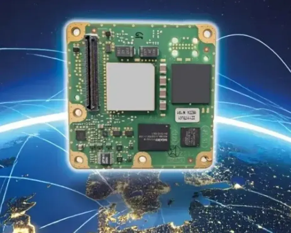
Ultra-low-noise amplifiers developed by European Engineering Consultancy Ltd. (EECL) are operating in orbit on the European Space Agency’s (ESA’s) HydroGNSS mission, marking a technical milestone for the hardware following the satellites’ launch in November 2025.
HydroGNSS consists of two small satellites designed to measure hydrological and climate-related variables using GNSS reflectometry. The satellites collect signals transmitted by navigation satellites such as GPS and Galileo and analyze those signals after they reflect from Earth’s surface. The reflected signals provide data on environmental parameters including soil moisture, freeze–thaw conditions in permafrost regions, wetlands and inundation, and above-ground biomass.
The satellites were launched aboard a SpaceX Falcon 9 rideshare mission from Vandenberg Space Force Base in California on Nov. 28, 2025. The mission is part of the European Space Agency’s Scout program, which focuses on relatively small and cost-effective Earth observation satellites designed to demonstrate new measurement techniques.
EECL designed and manufactured six multiband ultra-low-noise microwave amplifiers used in the spacecraft payload. The amplifiers are part of the radio-frequency front end of the receiver system and are designed to amplify very weak reflected GNSS signals while minimizing additional noise, helping preserve signal quality for scientific analysis.
Early on-orbit results indicate the satellites’ payloads are functioning as expected. Both spacecraft have begun collecting delay-Doppler maps of reflected GNSS signals, an early step in commissioning that confirms the receivers are acquiring and processing signals properly.
The HydroGNSS satellites were built by Surrey Satellite Technology Ltd., which also developed the GNSS receiver used on the mission. The spacecraft operate in low Earth orbit and are phased apart to increase global coverage of the measurements.
Data from HydroGNSS are expected to support research on the global water cycle and contribute to studies related to climate monitoring, agriculture, flood risk and ecosystem changes.
The small-form-factor Galileo OS (Open Service) or PRS (Public Regulated Service) sensors are designed to enhanced GNSS receivers and resilient multi-sensor navigation systems, ensuring safer and more reliable satellite-based navigation.
The Galileo PRS core module integrates a certified, single-chip, application-specific integrated circuit (ASIC) security module that incorporates all the necessary Galileo PRS security and navigation functions. It provides dual-frequency (E1/E6) iono-free Galileo PRS positioning, velocity and timing services. It also provides pseudorange and delta pseudorange raw data, along with GPS C/A (coarse acquisition).
The low-SWaP (size, weight and power) digital solution has been designed to work with any European GNSS receiver manufacturer seeking a standardized, easy-to-integrate Galileo module with which to develop their own GNSS receivers.
Credit: Thales
The modules can meet the requirements of a wide range of applications for manned or unmanned vehicles, combat aircraft, helicopters, high-dynamic missiles, and the navy. Their small form factor also makes them suitable for platforms with size constraints, such as ground vehicles, small drones and guided munitions.
The modules feature standardized interfaces, enabling the Galileo PRS function to be easily integrated into the host system. Furthermore, the TopStar Galileo core module can be embedded with minimum impact by using the analog RF front end of the host receiver.
The Galileo OS core module version enables the early integration of Galileo functionalities into the host system, as well as export to countries not authorized to use PRS. The PRS core module version provides an easy upgrade to Public Regulated Service capability, offering greater resilience against jamming and crucial protection against spoofing.
Austria is breaking new ground in space. BeaconSat is the largest satellite ever developed in Austria and also the country’s first military satellite. The project is being led by Austrian start-up GATE Space, based in Schwechat. Launch is planned for February 2027 aboard a SpaceX Falcon 9 rocket.
BeaconSat is designed to detect and analyze jamming and spoofing attacks on GNSS — targeted attempts to interfere with and manipulate navigation signals such as GPS or Galileo. Austria is responding to a security policy development that has real implications for aviation, transport, energy supply, and military operations.
Attacks on critical infrastructure
Jamming and spoofing incidents are frequent in geopolitically tense regions. In aviation, repeated disruptions have affected civilian aircraft.
“Space is now a central component of Europe’s and Austria’s security and defense strategy,” said Major General Friedrich Teichmann, head of the ICT and Cybersecurity Center. Navigation signals have long been part of critical infrastructure, and securing them is therefore of great strategic importance.
However, many of these attacks remain invisible. Countries often do not know where the interference is coming from, how systematic it is, or what pattern lies behind it. This is where BeaconSat comes in.
Technology demonstrator with strategic dimension
BeaconSat will systematically detect and analyze GNSS interference signals from orbit for the first time. The aim is to obtain data on when and where navigation systems are being deliberately disrupted. The mission is designed as a multi-year research and development project.
“It is important that we are able to act independently in terms of communication and navigation when necessary. This is a question of resilience and military capabilities,” emphasized Defense Minister Klaudia Tanner. “Space is an essential part of military capability.”
The satellite is not intended to be an isolated military project, but rather a demonstrator. Civil space technologies are being further developed for security-related applications and tested under real-world conditions. The findings will be incorporated into the operational processes of the Federal Ministry of Defense (BMVL).
Austrian industry at the center
GATE Space has overall responsibility for the project. Founded in 2022, the spin-off from TU Wien develops chemical propulsion systems for satellites and currently employs around 27 people. For BeaconSat, the company is supplying the propulsion system, the satellite structure, and the thermal management system, among other things.
“With BeaconSat, we are making a direct contribution to Europe’s security. The market for such capabilities is huge,” said Managing Director Moritz Novak.
The engines were tested in more than 8,000 hot runs at the site near Vienna Airport, both under atmospheric conditions and in one of Europe’s most powerful vacuum chambers.
GATE Space was supported by the Federal Ministry for Innovation, Mobility, and Infrastructure (BMIMI) through Austria Wirtschaftsservice (aws) with funding of around 750,000 euros.
Jamming and spoofing detection
A central contribution to the payload comes from the Graz-based company IGASPIN, which develops systems for the precise detection and analysis of GNSS interference. Additional components, including the on-board computer, are supplied by the Danish company Space Inventor.
At the European level, the mission is supported and co-financed as a technology demonstration via the European Space Agency’s ESA Marketplace. Off-the-shelf systems are specifically used to test commercially available technologies under security-relevant conditions.
New space chapter in the Ministry of Defense
BeaconSat also marks a turning point institutionally. The BMLV is currently setting up its own organizational unit for space services. The focus is on three areas: satellite communication, satellite navigation, and satellite-based reconnaissance.
“These space services are key to cross-domain operations and make a substantial contribution to the Austrian Armed Forces’ modern reconnaissance, command, and control network,” Teichmann said.
BeaconSat will provide data that will be directly integrated into military decision-making processes. At the same time, the project contributes to European resilience: those who recognize threats early on can respond diplomatically, politically, or technically.
Space as a growth area
The strategic importance of space technologies is growing both in terms of security policy and economics. Austria has recently increased its contribution to the ESA from 260 to 340 million despite budgetary constraints. Space and aviation technologies are anchored in the government’s industrial strategy as one of nine key technology fields.
Satellites have long been considered critical infrastructure. They enable navigation, communication, Earth observation, climate monitoring, and security applications. At the same time, new markets are emerging in the areas of propulsion systems, data analysis, and dual-use technologies.
With BeaconSat, Austria is repositioning itself in terms of security policy and industry. The project is an example of how startups, established technology companies, ministries, and European partners can and must work together successfully.
In recent years, scientists have shown that detecting changes in navigation signals from GPS and Galileo after they bounce off Earth’s surface (GNSS reflectometry, or GNSS-R) can deliver valuable information on sea ice. Now research drawing on data from Spire Global has enabled the generation of Arctic-wide sea ice maps, marking a major step forward for the emerging technique.
Spire Global‘s sea ice freeboard maps use data captured by Spire’s GNSS-reflectometry multipurpose listening constellation.
The research — enabled by the Third Party Missions (TPM) programme of the European Space Agency (ESA) — suggests that harnessing reflected navigation signals could become an important complement to established ice-monitoring altimetry missions.
The study leveraged Spire’s GNSS-R data to retrieve sea ice freeboard measurements across an entire winter season. The results show strong alignment with established altimetry datasets, including the ESA’s CryoSat mission, validating the complementary role of commercial satellite data alongside government missions.
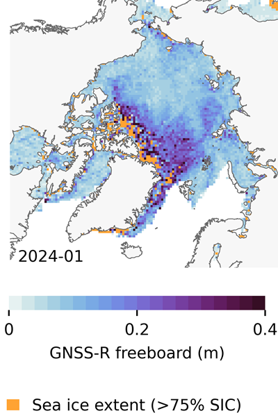
Arctic-wide sea ice freeboard map for January 2024. (Credit: ESA)
The study was led by Felix Müller at the Technical University of Munich (DGFI-TUM) and Robert Ricker at the Norwegian Research Centre, experts in GNSS-R.
“The primary purpose of signals emitted from GNSS is to fix the location of a device at any point on Earth,” Müller explained. “However, when these signals bounce off Earth’s surface, their properties change. By analyzing these changes, we can infer information about the characteristics of Earth’s surface.”
“Previous research has shown that this technique works well experimentally,” Ricker added. “Using the Spire constellation, we aimed to demonstrate whether it would hold up on a larger scale by generating an Arctic-wide map of sea ice freeboard, which is a measure of how far ice protrudes above the waterline.”
Spire’s GNSS-R constellation
Spire’s constellation was first used to sample the atmosphere for weather forecasting. Then scientists began exploring other applications. Spire started collecting reflected signals arriving at shallow angles using a technique called grazing-angle GNSS-R. This method is particularly well suited for ice monitoring.
The research team analyzed data detected over the Arctic Ocean and surrounding seas between October 2023 and July 2024. The data was obtained via the TPM program, through which ESA disseminates data from a range of commercial and institutional partners on a free basis for research and development purposes.
The team focused on one of the most critical challenges in sea ice altimetry: reliably identifying narrow openings in the ice pack, known as leads. These openings are reference points for determining sea surface height and, ultimately, sea ice freeboard.
In turn, sea ice freeboard can be used to infer sea ice thickness — an essential parameter for tracking climate change, estimating sea level, and modeling ocean and weather patterns.
Identifying leads in sea ice with GNSS-R data. (Credit: ESA)
Classifying surface properties
“In the initial phase of the project, we used two complementary methods to identify surface properties based on GNSS-R data, with the aim of identifying leads,” Müller said.
The first — known as the adaptive threshold technique — involved measuring the power of the reflected navigation signal to classify surface type as either water or ice. This method allows rapid processing of the entire GNSS-R dataset, while remaining robust to changes in signal conditions.
The second method — known as unsupervised clustering — offers a more complex approach to classifying surface conditions. In addition to signal power, it considers multiple other signal features that tease out more nuanced information on surface type, including identifying thin or refrozen ice.
Both methods were compared with co-located CryoSat surface-type classifications and Sentinel-1 imagery, confirming that the GNSS-R classifications were largely comparable against conventional satellite products.
Mapping sea ice freeboard
“Building on this classification work, we then took the research to the next step by producing Arctic-wide sea ice freeboard maps from GNSS-R data,” Ricker said.
The team corrected ice surface height measurements generated from GNSS-R data for tidal variations, sea surface height, and atmospheric delays, which is standard practice in altimetry. A refined algorithm then identified where leads in the ice were likely to occur, with the lowest points in these areas revealing estimated sea surface height. Sea surface height estimates were then subtracted from ice surface heights to retrieve freeboard. Using this approach, monthly gridded freeboard products were generated for the full winter season.
The team reported that the GNSS-R datasets showed strong agreement with CryoSat freeboard datasets across much of the Arctic, confirming that GNSS-R can reproduce large-scale patterns previously observed by dedicated altimetry missions. Independent validation against upward-looking sonar measurements in the Beaufort Sea further supported the accuracy of the retrieved freeboard values.
However, as expected, the GNSS-R estimates became less reliable during spring, when surface melt alters reflection characteristics. This limitation is consistent with earlier GNSS-R and radar altimetry studies and remains an active area of research.
The contribution of commercial data
While GNSS signals have long been used for positioning, this research highlights how reflected signal analysis can extend their value into large-scale Earth observation applications, delivering persistent coverage independent of sunlight or weather conditions, said Theresa Condor, Spire Global CEO.
“Advances in miniaturization, digital signal processing, and machine learning have fundamentally changed what’s possible in RF sensing,” Condor said. “Commercial constellations can now deliver persistent, high-quality RF data that complements traditional government systems with greater flexibility and cost efficiency.
“As environmental monitoring requirements intensify, we’re seeing agencies increasingly integrate commercially sourced RF datasets into operational architectures, reflecting the continued maturation of this market and the growing role of commercial infrastructure in government missions.”
“By producing analysis-ready gridded datasets, this work marks an important milestone in the progress of grazing angle GNSS-R from an experimental method to a reliable technique for mapping Arctic sea ice freeboard at scale,” said Matthieu Talpe, Remote Sensing Product Engineer, Spire Global. “In doing so, it strengthens the case for the grazing angle GNSS-R technique employed by the Spire constellation as a valuable complement to existing ESA and partner missions, helping to close observational gaps in one of Earth’s most rapidly changing regions.”
The GPS World Buyers Guide is the only comprehensive, continuously updated directory of leading providers across several industry segments. Watch for the latest version in the May/June issue.
Adding your listing has never been easier, with over 40 businesses already listed and available for contact.
Why should you be in our Buyer’s Guide?
Basic Listings are free
Year-round online visibility
Comprehensive and continuously updated
Deemed “a must-read, keeper issue” with our more than 30,000 loyal monthly magazine readers — verified annually by a third-party auditing firm as GNSS/PNT buyers, integrators, and specifiers
Questions about the online or print Buyers Guide? Contact Petra Turko via email, [email protected]
Collaboration focused on enabling plug-and-play, GPS-denied navigation capabilities for next-generation maritime platforms
Anello Photonics and Mythos AI are accelerating deployment of resilient, plug-and-play navigation solutions for the maritime sector. The collaboration brings together Anello’s advanced inertial sensing technology and Mythos AI’s intelligent autonomy software to address the growing need for resilient navigation in GPS-challenged environments.
Anello is creator of the Silicon Photonics Optical Gyroscope (SiPhOG). By combining SiPhOG-based inertial navigation with advanced sensor fusion and AI-driven collaborative autonomy, Anello and Mythos AI are delivering a fully integrated, plug-and-play solution that maintains performance when satellite signals are degraded or unavailable. It is designed to drop seamlessly into both next-generation and legacy maritime platforms. A multi-mission open systems architecture enables scalable deployment across defense, commercial and hybrid maritime operations.
Strategic focus on maritime autonomy and USVs
The initiative is particularly relevant to the rapidly evolving unmanned surface vehicle (USV) market. As USVs take on expanded roles in offshore energy, maritime security, hydrography, environmental monitoring and defense missions, complete end-to-end dependable navigation is essential to safe and effective operations.
A resilient, GPS-independent navigation capability enables:
greater operational assurance in GPS-denied or contested maritime environments
enhanced autonomy and mission continuity during signal disruptions
reduced integration complexity for OEMs and system integrators
scalability across a broad range of vessel sizes and mission profiles.
Anello and Mythos AI will collaborate with OEMs, integrators and end users to align the solution with evolving operational and regulatory demands.
Organizers of Jammertest, a large-scale trial of GNSS resilience technologies, is now open to applications. Jammertest 2026 will take place Sept. 14-18 in Norway.
Application deadline is April 6.
Jammertest is an annual event held at Andøya, recognized as the largest open PNT/GNSS resilience testing event in the world. The event provides a unique opportunity to test the robustness of navigation and positioning systems.
For the fifth consecutive year, the Norwegian Public Roads Administration, Norwegian Communications Authority, Norwegian Defense Research Establishment, Norwegian Metrology Service, Norwegian Space Agency, Norwegian Mapping Authority, Avinor and Testnor will be organizing the event.
Due to high demand, there will be an application process, and selected participants will be invited to attend. Jammertest partners reserve the right to select participants based on Norwegian national interest and needs.
The application pertains to the entire organization and is not individual. This means that each organization only needs to submit one application.
To learn more about the application process, visit the Jammertest website.
Hexagon | NovAtel has joined the GPS Innovation Alliance (GPSIA) as its newest member.
NovAtel develops positioning, navigation and timing (PNT) products for land, sea and air applications, with users in agriculture, defense, autonomous mobility and marine sectors. The company’s portfolio includes high-precision GNSS receivers, correction services, sensor fusion systems, GNSS anti-jam technology and post-processing solutions.
GPSIA Executive Director Lisa Dyer said the addition comes at a critical time for PNT infrastructure.
“NovAtel brings world-class expertise in high-precision GNSS, inertial integration, and anti-jam capabilities that help protect critical services people rely on every day, from transportation and public safety to the supply chains and infrastructure that power the world’s economy,” Dyer said. “Their leadership will strengthen GPSIA’s work to protect GPS and complementary PNT technologies from harmful interference and to accelerate the innovation that underpins the decades-long reliability of these systems.”
Jonathan Auld, president of NovAtel’s Positioning Division at Hexagon, said the company plans to use its membership to raise awareness of PNT’s role in critical industries.
“From precise positioning and correction services to resilient solutions that help mitigate interference, we support customers operating in mission- and safety-critical environments,” Auld said. “We look forward to working with GPSIA to heighten awareness of the role these technologies play in innovation, critical infrastructure, and economic growth.”
NovAtel joins existing GPSIA members Apple, Garmin, Deere & Company, Lockheed Martin, Trimble and TrustPoint, along with organizations participating in the alliance’s affiliates program. GPSIA describes its mission as protecting, modernizing and advancing GPS, GNSS and complementary PNT technologies.
Michigan Technological University library and department of social sciences are examining 11,000 historical images of Michigan’s Upper Peninsula (Copper Country), to find precisely where a photographer stood to take the photo.
The location will provide richer information about a place’s surroundings, especially in circumstances where structures or environmental landmarks are no longer present.
The project also will transform how people search for historical images, according to Bob Cowling, the school’s geographic information system (GIS) data librarian. Searching by keyword terms relies on accurate metadata. If there isn’t good data governance from the organization managing the images, then the metadata could be missing important fields.
Donated historical images often arrive without any dates or location information attached to them., but now will be easier to find on a map, making it possible to visualize what was there in the past compared to today.
The European Space Agency (ESA) is preparing for the inaugural launch of the Celeste LEO-PNT in-orbit demonstration mission, with the first two satellites scheduled to lift off no earlier than March 24 aboard Rocket Lab’s Electron rocket from the company’s Māhia Launch Complex in New Zealand.
Celeste will play a pioneering role in elevating the future of Europe’s satellite navigation capabilities. As Europe’s first initiative for satellite navigation in low Earth orbit (LEO), the mission will be testing next-generation technologies and add new frequency bands for satellite navigation.
Celeste will demonstrate how a complementary layer flying closer to Earth can enhance Europe’s current Galileo system in medium Earth orbit (MEO), boosting the overall resilience, enhancing its performance, and opening opportunities for new service capabilities directly from LEO.
The first two satellites successfully completed their test and qualification campaign and are formally declared ready for flight. The satellites are being shipped to Rocket Lab’s launch complex in New Zealand, where they will undergo final testing and integration in the Electron rocket ahead of their launch no earlier than March 24.
Similarly to the early stages of the Galileo programme, Celeste will begin with two demonstrator satellites to secure the assigned frequency filings and to test representative navigation signals until the end of the year.
The two satellites consist of two large CubeSats (12U and 16U respectively), both developed by two consortia composed of a wide set of European players, one led by GMV (Spain) and the other led by Thales Alenia Space (France).
Together, they will enable in-orbit testing of next-generation technologies, including autonomous precise orbit determination without reliance on ground infrastructure, as well as stronger and faster radionavigation signals in L- and S-band from low Earth orbit.
Over the past months, both satellites successfully completed payload integration, radio-frequency compatibility tests, and environmental qualification, including thermal vacuum, mechanical and electromagnetic compatibility testing.
The Cubesat, built by Thales Alenia Space, being integrated. (Credit: Thales Alenia Space)
More satellites to follow
Eight larger satellites with additional capabilities are under development, with GMV and Thales Alenia Space each responsible for four of them. Design and development are progressing steadily, with an opportunity for subsequent launches from 2027 onwards.
The eight satellites will build on the work of the first two satellites and demonstrate radionavigation with additional novel signals and new frequency bands:
S-band two-way navigation signals, for advanced positioning capabilities using 5G satellite waveforms.
C-band signals, for additional resilience against jamming and interference.
UHF-band signals, for enhanced penetration and in-door positioning.
“On top of the eight satellites, an additional one will include a payload to test miniaturised atomic clocks on board, along with other technologies,” said Roberto Prieto-Cerdeira, ESA’s Celeste project manager.
Once fully completed at an orbit between 500 and 560 km, the demonstrator mission will offer an ideal in-orbit testbench for a broad variety of downstream applications, such as autonomous vehicles, maritime navigation, critical infrastructure, polar and arctic operations, wireless networks, emergency services, asset tracking and Internet-of-Things applications.
“By carrying out these experimentation and demonstration activities in orbit, we are opening a platform where ESA can work hand-in-hand with end-user communities and stakeholders to demonstrate innovative technologies in satellite navigation, push boundaries and demonstrate services in conditions that mirror the real world,” added Roberto.
ESA is offering interested third parties from ESA Participating States the opportunity to participate in the experimentation phase of the Celeste in-orbit demonstrator. More information is available on ESA’s Open Space Innovation Platform.
Following Celeste’s in-orbit demonstration, Celeste’s in-orbit preparatory phase, approved at ESA’s Ministerial Council in November 2025 (CM25), will focus on technology development, industrialisation and in-orbit validation, preparing for a potential operational system as part of the European Union GNSS infrastructure together with Galileo and EGNOS, also supporting potential commercial initiatives.
Belgium company Agilica is offering a GNSS-independent onboard positioning system using ultra-wideband (UWB) technology. The system enables precise, autonomous drone navigation and landing, even in dynamic, GNSS-denied environments or on moving targets.
The company says the system achieves centimeter accuracy in real time, enhancing safety and precision. It supports multiple drones and mobile assets in dynamic conditions.
Developed in 2018 as a research and development initiative at the Royal Military Academy in Brussels, Agilica has evolved into a company focused on developing high-accuracy positioning and navigation solutions for drone and robotic applications.
On Feb. 19, the Finnish government submitted a legislative proposal to parliament to criminalize possession and import of radio-frequency jammers and spoofers, including those blocking GNSS signals
According to Ministry of Transportation and Communications, the amendments would be made to the Act on Electronic Communications Services. The government proposes to amend the provisions on equipment that jam or spoof radio communications.
Unauthorized use of jammers is already banned. The government proposes to criminalize unauthorized possession of jammers, enabling confiscation and improving the authorities’ ability to intervene in the unauthorized possession and import of such devices. The proposal would introduce a distinct definition for jammers, separate from radio equipment, allowing for stricter regulation.
The amendment would set clearer conditions for the use and possession of jammers for the authorities and other authorized parties. The possession and use of jammers for research and product development would be permitted under a license if certain conditions are met.
The proposal would also introduce exceptions for NATO and its member states regarding the right of the Finnish Transport and Communications Agency (Traficom) to check radio equipment or jammers and confiscate them for inspection.
Parliament will first hold a debate on the government proposal in a plenary session. The proposal will then proceed to a committee reading. Following the committee report, the debate will continue in a plenary session.
The Act is scheduled to enter into force on July 1.