Russia warned it could blow up 32 GPS satellites with its new anti-satellite technology, ASAT, which it tested Nov. 15 on a retired Soviet Tselina-D satellite, according to numerous news reports.
Russia then claimed on state television that its new ASAT missiles could obliterate NATO satellites and “blind all their missiles, planes and ships, not to mention the ground forces,” said Russian Channel One TV host Dmitry Kiselyov, rendering the West’s GPS-guided missiles useless. “It means that if NATO crosses our red line, it risks losing all 32 of its GPS satellites at once.”
The International Space Station (ISS) Flight Control team was notified of indications of a satellite breakup, causing 1,500 pieces of debris to threaten the station. “Due to the debris generated by the destructive Russian Anti-Satellite (ASAT) test, ISS astronauts and cosmonauts undertook emergency procedures for safety,” said NASA Administrator Bill Nelson.
“With its long and storied history in human spaceflight, it is unthinkable that Russia would endanger not only the American and international partner astronauts on the ISS, but also their own cosmonauts,” Nelson said. “Their actions are reckless and dangerous, threatening as well the Chinese space station and the taikonauts on board. All nations have a responsibility to prevent the purposeful creation of space debris from ASATs and to foster a safe, sustainable space environment.
“Russia has demonstrated a deliberate disregard for the security, safety, stability and long-term sustainability of the space domain for all nations,” Gen. James Dickinson, commander of U.S. Space Command, said. “Russia’s tests of direct-ascent anti-satellite weapons clearly demonstrate that Russia continues to pursue counterspace weapon systems that undermine strategic stability and pose a threat to all nations.”
Photo: Stanislav Ostranitsa/iStock/Getty Images Plus/Getty Images
Construction of the New National GNSS Frame Network of the Italian Space Agency (ASI) has been completed. The new network, built by e-GEOS, will provide up-to-date, high-precision geodetic information via GNSS signals for the scientific community and professional and entrepreneurial operators. E-GEOS is a company belonging to Telespazio (80%) and an investee of ASI (20%).
There are 46 stations distributed evenly across the Italian peninsula that will acquire the signals from GPS, GLONASS, BeiDou and Galileo.
ASI’s GNSS network, which was designed and developed to provide indispensable support for the global geodetic networks—such as the International GNSS Service (IGS) and the EUropean REference Frame (EUREF)—will produce data for the management of the International Terrestrial Reference Frame (ITRF).
It will make a variety of products and services possible, such as determining the orbits of GNSS satellites with an accuracy to the nearest centimeter. It will also time-synchronize the satellites to better than one nanosecond, useful both for on-site applications as well as to support satellites equipped with GNSS receivers.
The new network will enable ASI and e-GEOS to intensify and fine-tune the joint scientific and operational development underway for the last 25 years at the ASI Space Center in Matera in the field of meteorology, as well as the study of climate change and space weather.
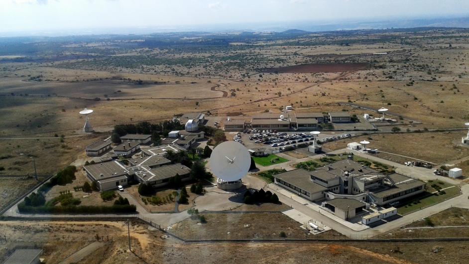
The ASI Space Centre in Matera. (Photo: ASI)
Specifically, the network will enable the provision to the national supply chain—from research centres to SMEs, universities and major corporations—of products and services useful for developing innovative, high-precision positioning applications, which can be implemented in a wide variety of sectors, such as precision farming.
To contribute to scientific activities, some stations in the new GNSS network have been installed in significant locations where purpose-designed structures are already present.
All the data acquired by the New National GNSS Frame Network will be received, processed and stored at ASI Space Centre in Matera and provided to all interested users.
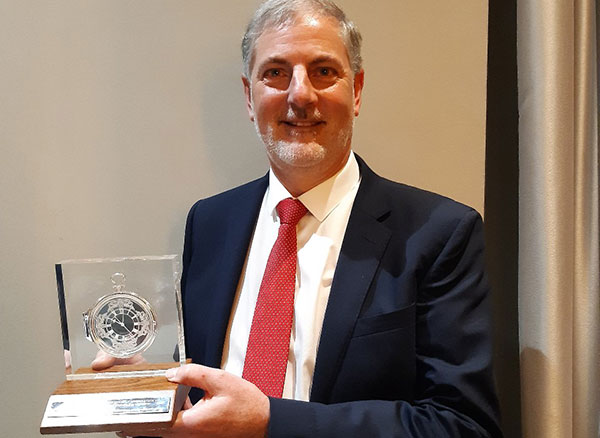
Terry Moore is the first British academic to take home the John Harrison Award for outstanding contributions to navigation.
Terry Moore
Terry Moore, a positioning and navigation expert at the University of Nottingham and longtime GPS World Editorial Advisory Board member and author, has become the first British academic to win a prestigious international award in the field.
Terry Moore is an Emeritus Professor and former director of the Nottingham Geospatial Institute at the University’s Faculty of Engineering.
The International Association of Institutes of Navigation (IAIN) awarded Moore with its John Harrison Award for outstanding contributions to navigation. The award ceremony took place during a special session of the Navigation 2021 Conference in Edinburgh, which took place Nov. 16-18.
HRH The Princess Royal (Princess Anne) attended via Zoom to present the award, and had a one-to-one conversation with Professor Moore.
The John Harrison award is a premier global award in the navigation field and Professor Moore is its first British winner.
“It’s a great honor to be recognized by the global navigation community, and I feel quite humbled,” Moore said. “John Harrison was a simple country carpenter in the 18th century who solved the major problem of measuring longitude at sea, through his remarkable marine chronometers. Despite his genius, he struggled for acceptance by the scientific establishment, and it took many years until he received the recognition (and financial reward) he deserved. It is sad that over 200 years later we are still fighting for improved equality, diversity and inclusion throughout scientific disciplines. I am absolutely delighted to receive the award in his name.”
A professor of satellite navigation for 20 years at the university, Moore’s association with Nottingham goes back to his undergraduate degree starting in 1979. During his distinguished career, all of it spent at Nottingham, he has taken a leading role in national and European initiatives aimed at integrating academic research and teaching activities in GNSS. He has also interacted closely with industry throughout that time.
He was the founding director of GRACE — the GNSS Research and Applications Centre of Excellence — which was jointly funded by the University and the East Midlands Development Agency and has now been extended to cover all geospatial applications as the Geospatial Research and Applications Centre of Excellence.
Moore has overseen numerous research projects funded by industry, research councils, the European Space Agency and the European Commission, and has supervised almost 40 successful PhD students.
He is a Chartered Engineer, a Fellow and the Immediate Past President of the Royal Institute of Navigation (RIN) and also a Fellow and a Member of Council of the Institute of Navigation (ION) in the United States. He was recently elected as the Chair of the European Group of Institutes of Navigation (EUGIN), and is an Honorary Member of IAIN. In 2013 he was awarded the RIN Harold Spencer-Jones Gold Medal. He received RIN’s J E D Williams Medal and the ION Johannes Kepler Award, both in 2017.
Professor Moore is a member of the U.S. National Space-Based Positioning, Navigation and Timing (PNT) Advisory Board and is a Member of the European Space Agency (ESA) GNSS Science Advisory Committee. He was an expert contributing to the UK Government Blackett Review on GNSS Vulnerability and has worked extensively on the UK’s PNT Strategy.
He is a Fellow of the Chartered Institution of Civil Engineering Surveyors, a Fellow of the Royal Astronomical Society, and an Associate Fellow of the Remote Sensing and Photogrammetry Society, and is a Member of the Editorial Advisory Council of The Journal of Navigation.
“Many congratulations to Terry on this outstanding achievement,” said Stuart Marsh, director of the NGI. “It is fantastic to see our former director, who has spent so many years of his career in our faculty, serving in many different capacities, receive such a high honor.”
On Nov. 15, the European Union Agency for the Space Programme (EUSPA) opened the Galileo Open Service Navigation Message Authentication (OSNMA) Public Observation test phase for the secured signal.
The OSNMA is a freely accessible data-authentication function for the Galileo Open Service worldwide. OSNMA provides receivers a first-level of protection against spoofing the Galileo Open Service, assuming that the receiver meets requirements. This is realized by transmitting authentication-specific data in previously reserved fields of the E1 I/NAV message.
Galileo OSNMA improves confidence on the user side by enabling the user to verify the authenticity of the Galileo navigation parameters required for positioning, navigation and timing. In particular, it will allow the user to authenticate geolocation information of the Open Service:
the ephemerides and clock corrections
the ionospheric corrections
the status flags
the Broadcast Group Delay
the GST to UTC parameters
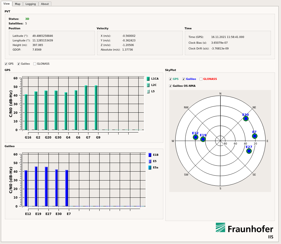
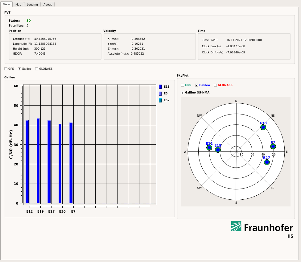
TeleOrbit quickly authenticates with Goose
In late 2020 and the first half of 2021, TeleOrbit GmbH and Fraunhofer IIS worked on a project to implement the Galileo OSNMA capabilities onto its powerful and compact GNSS receiver lab “Goose”. This project, completed in May, successfully authenticated simulated OSNMA signals.
For the new phase, the team at Fraunhofer IIS adapted the setup to the newly published Interface Control Documents (ICDs) and receiver guidelines, and was able to authenticate the live signal on Nov. 16.
The screenshots below show snapshots of the Goose user interface with enabled OSNMA and successfully authenticated satellites, indicated by the green circle surrounding the blue Galileo satellites in the skyplot.
Interested users can sign up for this OSNMA test phase on GSC website. The site provides access to all corresponding documents and information, including the current ICD, receiver guidelines, OSNMA public key and Merkle Tree Root — both needed for the authentication process.
To learn about using GOOSE for your own tests and projects, contact [email protected].
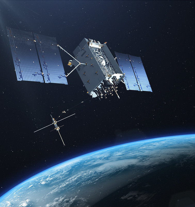
The U.S. Space Force exercised its second contract option valued at approximately $737 million for the procurement of three additional GPS III Follow On (GPS IIIF) space vehicles (SVs) from Lockheed Martin on Oct. 22, 2021. This contract option is for GPS IIIF satellites 15, 16 and 17 (SV15-17).
GPS IIIF satellites build off the innovative design of Lockheed Martin’s next generation GPS III satellites (SV 01-10), which provide three times greater accuracy, up to eight times improved anti-jamming capability and increased resiliency, in addition to modernization, compared to legacy GPS satellites in today’s constellation. GPS III also adds a new L1C civil signal that is compatible with other global navigation satellite systems, such as Galileo.
“GPS IIIF satellites will add new capabilities and advanced technology to the GPS constellation, including Regional Military Protection (RMP); an upgraded Nuclear Detection Detonation System (NDS) payload; a safety-improving Search and Rescue payload; and an accuracy-enhancing Laser Retroreflector Array (LRA),” said Dave Hatch, Lockheed Martin’s GPS IIIF program management director. “The RMP capability further reinforces GPS III/IIIF as a warfighting system, providing up to 60x greater anti-jamming for our warfighters operating in contested environments.”
The GPS IIIF SV11-12 satellites were included in the original September 2018 GPS IIIF contract award to Lockheed Martin to build up to 22 GPS IIIF satellites. Under that contract, the government exercised the first GPS IIIF production option for SV13-14 in October 2020.
GPS IIIF SV13 and beyond will incorporate the company’s LM2100 Combat Bus, an enhanced space vehicle that provides even greater resiliency and cyber-hardening against growing threats, as well as improved spacecraft power, propulsion and electronics. This evolved bus incorporates many common components and procedures to streamline manufacturing. LM2100 Combat Bus vehicles are also capable of hosting Lockheed Martin’s Augmentation System Port Interface (ASPIN), which would allow for future on-orbit servicing and upgrade opportunities.
Today Lockheed Martin is close to finishing production on the original GPS III SV1-10 contract. GPS III SV01-05 have been launched and handed over to the Space Force for on-orbit operations. GPS III SV06-08 have been completed and placed in storage at the company’s facility waiting for the Space Force to call them up for launch. SV09 is a fully integrated space vehicle now going through final testing.
On October 26, 2021, the final GPS III satellite of the original GPS III contract – GPS III SV10 – completed an operation known as “core mate” to assemble it into a full space vehicle at Lockheed Martin’s GPS III Processing Facility. It will proceed into the vehicle testing campaign before year-end.
Peter Teunissen, senior professor at Curtin University, was named as Australia’s top researcher in two fields — geophysics and radar, positioning and navigation — by The Australian’s “2021 Research Magazine.” Teunissen, who has seen the field of satellite technology expand at a phenomenal rate over the past few decades, said that dependence on GNSS has penetrated all levels of society. “The timing systems we are using for computers, the synchronization of timing – that’s all linked to GNSS,” he says. “All those satellites are equipped with the most accurate atomic clocks. We are all now dependent on those GNSS systems.”
Teunissen moved to Australia more than a decade ago from The Netherlands and was awarded an Australian Research Council Federation Fellowship. He specializes in interferometric GNSS, the use of satellite signals for the high precision measurement of the parameters of water and land masses; has been associated with Curtin University since 2009; and is now an award-winning and internationally-recognized expert in the field of satellite technology.
“Cubesat” mini-satellites increasingly deployed by universities and corporations have also caught Teunissen’s attention, who calls them “the future for increasing the number of satellites and constellations.”
The U.S. President’s National Space-based Positioning, Navigation and Timing (PNT) Advisory Board will meet on December 9 and 10 at the Sheraton Pentagon City Hotel in Arlington, VA, according to a post on the group’s website.
The meeting is open to the public. Interested parties are encouraged to attend.
The agenda, while still not finalized, is expected to include a full day public meeting on Thursday, December 9, and a half day on Friday, December 10.
Previous in-person meetings have included program updates from government departments and briefings on cutting edge government and industry projects on the first day. The second day normally sees updates from international representatives and open discussion of current issues among the board members.
The Advisory Board’s size is expected to increase at this meeting with three previous members leaving and nine newly appointed members being added.
A formal announcement of the meeting is expected in the Federal Register on Monday, November 15. Confirmation of the new membership roster is expected at about the same time.
The PNT Advisory Board was established in 2004 by National Presidential Security Directive 39, “U.S. Space-Based Positioning, Navigation, and Timing Policy.” It operates under the rules of the Federal Advisory Committee Act and is tasked with providing advice “… on U.S. PNT policy, planning, program management, and funding profiles in relation to the current state of national and international space-based PNT services.”
The Advisory Board has regularly advised the government on all aspects of space-based PNT, including the need for a holistic “PTA” approach – “Protect” signals, “Toughen” user equipment, and “Augment” services with alternative PNT sources.
This will be the first in-person meeting of the board since November 2019. A virtual meeting was held in July 2020.
After the conclusion of the government Advisory Board meeting on Friday, December 10, the non-profit Resilient Navigation and Timing Foundation will hold its annual membership meeting and lunch at the same venue.
The Airbus A350 can now be equipped with the Collins Aerospace GLU-2100 multi-mode receiver. (Photo: pablorebo1984/iStock/Getty Images Plus/Getty Images)
The Collins Aerospace GLU-2100 multi-mode receiver (MMR) has received approval by Airbus, making it available as line-fit and retrofit on Airbus A320, A330 and A350 aircraft. This a major step toward Collins offering next-generation GNSS to the commercial aviation marketplace.
An MMR assists pilots in positioning, navigating and landing an aircraft. Building on the GNSS capabilities of previous MMRs, the GLU-2100 provides a satellite-based augmentation system (SBAS) and ground-based augmentation system (GBAS). This supports the integrity of the aircraft position, as well as the accuracy and availability of demanding aircraft operations such as landing in low visibility conditions.
The GLU-2100 MMR ensures that commercial aircraft can meet flight zone global mandates, while also proofing the technology by providing a solid foundation for future growth. It includes the flexible hardware baseline necessary to implement future GNSS capabilities, such as multi-frequency and multi-constellation (MFMC), and GBAS Category II/III via software-only update.
Acquisition of FlightAware tracking platform
In August, Collins Aerospace signed a definitive agreement to acquire privately held FlightAware, a digital aviation company providing global flight-tracking solutions, predictive technology, analytics and decision-making tools.
Closure of the acquisition is subject to the completion of customary conditions and regulatory approvals. Following closing, FlightAware will join Collins’ Information Management Services portfolio within the company’s Avionics strategic business unit. Financial terms of the agreement were not disclosed.
Based in Houston, Texas, with approximately 130 employees, FlightAware was founded in 2005 and is a provider of real-time and historical flight information and insights to the global aviation community. FlightAware serves all segments of the aviation marketplace through applications and data services that provide comprehensive information about the current and predicted movement of aircraft.
Through the collection, interpretation and enrichment of hundreds of sources of data, FlightAware transforms millions of raw flight data elements and delivers them as coherent, easy-to-consume flight stories. The company has a proprietary terrestrial ADS-B network with tens of thousands of receivers spanning seven continents in 200 countries and territories.
Galileo Control Centre in Oberpfaffenhofen, Germany. (Photo: ESA)
Spirent Communications plc has launched a commercially available simulation test solution for the Galileo High Accuracy Service (HAS), via a beta interface implementation based on HAS ICD version 1.2. During the development of the solution, Spirent collaborated with GMV, a leader in cutting-edge GNSS high-accuracy technologies.
Galileo HAS will provide free-of-charge high-accuracy Precise Point Positioning corrections through the Galileo E6-B signal, with accuracy under two decimeters, offering real-time improved user positioning performance. Developers need to be able to test their devices against this new service to ensure they can optimally capture the emerging capability when it becomes available. By integrating HAS simulation and capabilities, Spirent’s latest simulation solution enables customers to utilize and incorporate Galileo HAS as early as possible.
In February 2021, the European Union Agency for the Space Programme (EUSPA) awarded GMV with the contract for the implementation of the Galileo High Accuracy Data Generator (HADG), which will be the facility in charge of generating the high-accuracy corrections data to enable the provision of HAS. Spirent’s collaboration with GMV will prove a key element in the early adoption of the service.
“The high accuracy, feature richness and flexibility of Spirent’s simulator platforms provides an ideal foundation for the testing of innovative new Galileo services such as our recent Galileo HAS capability,” said David Calle, section head of advanced GNSS services at GMV’s aerospace sector.
“The high level of expertise and in-depth understanding of Galileo HAS within GMV provided important guidance as we implemented HAS on our simulation platform,” said Jan Ackermann, Spirent’s director of product line management. “This enabled us to again be the first in the industry to offer a commercial solution to simulate and test these important new capabilities.”
A Nov. 17 webinar will focus on ways to deter attacks on and interference with GPS satellites and signals. The webinar takes place 2:30-3:30 p.m. EST; register for free.
Rep. John Garamendi (D-CA) will provide opening remarks for the webinar, which is co- sponsored by Domestic Preparedness Journal and the Resilient Navigation and Timing Foundation. Garamendi is the chair of the House Armed Services Readiness Subcommittee and has long been concerned about the vulnerability of America’s GPS.
“America’s over-reliance on GPS makes it a high priority target for a wide range of bad actors,” said Dana A. Goward, president of the Resilient Navigation and Timing Foundation and one of the webinar moderators. “And, since other nations, such as China, Russia and Iran, have terrestrial systems they can use when space is not available, the U.S. is at a strategic disadvantage.”
This “technology resilience gap” is one of several dangers that could lead to armed conflict that webinar panelist George Beebe discusses in his book The Russia Trap. His concern is that having such a pronounced relative weakness can invite meddling and exploitation by adversaries. Even if done on a small scale, this could lead to a series of escalating responses ending in an unintended, much more serious conflict that neither party wants.
Beebe is vice president and director of studies at the Center for the National Interest. He spent more than two decades in government service as an intelligence analyst, diplomat and policy advisor, including service as director of the CIA’s Russia analysis and as special advisor to Vice President Dick Cheney for Russia/Eurasia and Intelligence Programs.
Eliminating the gap between the United States and its adversaries is key to protecting GPS and the nation, according to webinar panelist Greg Winfree, director of the Texas A&M Transportation Institute. Winfree previously served as an assistant secretary for the U.S. Department of Transportation. While acknowledging there is no single answer, he has asserted that providing at least one alternative system will go a long way toward “getting the bullseye off GPS.”
The third webinar panelist, Scott Pace, has supported Winfree’s approach. Pace is the director of George Washington University’s Space Policy Institute and former executive director of the National Space Council. He has commented that having an alternative to GPS will contribute to national security and improve global stability. It will “lower the pressure on us to escalate and respond” should GPS satellites be damaged or services disrupted.
“What’s new with GPS?” people often ask me when I tell them my job. Recently, I have been responding by telling them about the other three GNSS constellations now fully available. However, as reflected every month in these pages, that is but one of many developments that combine to make satellite navigation ever more accurate, reliable and ubiquitous.
While the GPS program is old by the standards of the digital age, it has never been static. In the 1970s, when GPS was developed, the expected accuracy for civilians was tens of meters, though pioneering commercial users began right away to chip away at the system’s limitations by developing differential GPS (DGPS), carrier-phase positioning, and other techniques. By the end of the next decade, better signal processing and the implementation of DGPS had brought civilian accuracy to about one meter. In the 1990s, phase-ambiguity resolution made real-time centimeter accuracy standard for surveyors.
As the adoption of cell phones exploded, it became imperative to locate them to preserve the 911 system. Initially, this was done using the time-of-arrival of signals to handsets from towers, because it was assumed that GPS receivers could not be made sufficiently small, cheap, fast, power-efficient and accurate to work in cell phones. The implementation of assisted GPS, now standard in all smartphones, largely solved those problems.
Precision for civil GPS users increased by an order of magnitude in May 2000, when President Clinton ordered the removal of Selective Availability, and substantially once enough satellites began to broadcast the L2 civil (L2C) code, enabling ionospheric corrections. Later, the modernized signals in the L5 band enabled sub-meter accuracy without augmentations and very long-range operations with augmentations. There are now more than 80 signals in that band, on GPS, Galileo and BeiDou satellites. On the military side, the effort to deploy M-code signals, cards and receivers continues.
Over the years, in addition to modernized satellites and signals, improvements have included the development of PPP, RTK and hybrid techniques; the proliferation of local, regional and global correction services; improved jamming and spoofing detection; and the increasing integration of GNSS receivers with other RF receivers as well as with inertial, optical, radar, lidar and other sensors.
Future improvements may include:
signal authentication
commercial systems in low Earth orbit that would have a signal strength on the surface three orders of magnitude greater than current GNSS, greatly boosting indoor reception and protection from jamming
inertially aided extended coherent integration, a.k.a. “supercorrelation,” which makes moving GNSS receivers more sensitive to signals they receive directly than to reflected ones
3D-mapping-aided GNSS, which enhances the positioning algorithms by identifying non-line-of-sight signals; this is being pioneered by Google in nearly 4,000 cities, relying on its 3D city models and machine learning.
The moment I send this month’s issue to the printer, I will think of more past and future improvements. As soon as you receive it, many of you will think of yet more. What’s new with GPS? A lot.
The General Lighthouse Authorities (GLA) of the United Kingdom and Ireland has named Alan Grant to the top post of its research and development team. Grant assumed his new role on Nov. 1.
As part of his duties, he heads the GLA’s research and development program, considering existing and future maritime requirements and operational strategy. GLA Research and Development (GRAD) is tasked with improving maritime safety by developing innovative and cost-effective maritime aids-to-navigation (AtoN).
GRAD projects have included all aspects of AtoN including human and machine interaction, operational life and environment. The team has deep technical expertise and experience with automatic identification systems (AIS) , the VHF Data Exchange System (VDES) , eLoran, e‑navigation, GNSS, SBAS and visual signaling.
The organization is well known for its expertise in electronic navigation aids and was an important contributor to the MarRINav project. The project effort was funded by the European Space Agency and examined what combination of electronic aids to navigation are needed to ensure uninterrupted UK shipping.
Grant joined the GLA in 2003 and has worked on a variety of systems during his time with GRAD. He led a series of successful GPS jamming trials and the development of the multi-system radionavigation receiver performance standards, from initial concept to international recognition at the IMO. He continues to support resilient positioning, navigation and timing in maritime navigation at both technical and strategic levels.
Grant is a Fellow of the Royal Institute of Navigation, where he is a member of the council and served as vice president, 2019-2021. He is also a member of the U.S. Institute of Navigation and served on the ION Council, 2013-2017.
Grant chairs the International Association of Marine Aids to Navigation and Lighthouse Authorities (IALA) radionavigation services working group and is a member of several international standards bodies. He is a chartered engineer, a chartered physicist, and author of more than 120 journal papers, magazine articles, and conference papers.
Martin Bransby, the prior GRAD leader, has taken a position with Telespazio in the UK.
Longstone Lighthouse is situated on the Outer Farne Islands on the Northumberland Coast in Northern England. (Photo: ad_foto/iStock/Getty Images Plus/Getty Images)