RINEX 4.00 (2021) is a major revision of the format document to modernize the navigation message files to be able to accommodate the new navigation messages from all the GNSS constellations, as well as system data messages such as ionospheric corrections, Earth orientation parameters and system time offsets.
The RINEX Working Group Chair Ignacio Romero provided an explanation to the GNSS community about the new RINEX 4.00 format that explains changes from previous RINEX versions.
The new format is also described in detail on the IGS Format and Standards page. For more information on the RINEX updates and activities, visit the RINEX WG Page.
The IGS adopted RINEX 4.00 during its 59th Governing Board Meeting on Dec. 7, 2021.
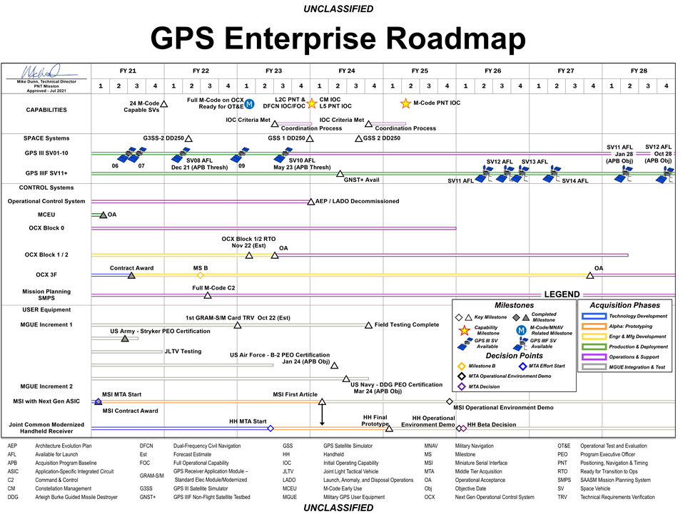
The U.S. Space Force has released a graph illustrating the GPS Enterprise Roadmap. The roadmap provides timelines for all the different elements of the GPS enterprise through the end of fiscal year 2028.
The link includes proposed changes for IS-GPS-200, IS-GPS-705 and IS-GPS-800 related to RFC-467 (2021 Proposed Changes to the Public Documents), as well as updated briefing charts for the 2021 GPS Public Interface Control Working Group (ICWG).
The updated documents reflect changes discussed at the 2021 Public ICWG on Sept. 29, 2021.
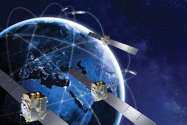
Galileo Second Generation Batch#1A satellites. (Image: ESA).
Successful European Cooperation
Galileo is Europe’s civil global satellite navigation constellation and a major success, being the world’s most precise satnav system and offering meter-scale accuracy to more than two billion users around the globe.
The signature of the Financial Framework Partnership Agreement (FFPA) on June 22, 2021, further strengthened effective cooperation between the European Commission (EC), the European Union Agency for the Space Program (EUSPA), and the European Space Agency (ESA) — key to successfully achieving a crucial EU Space Program component like Galileo in the current EU Multi Financial Framework (2021–2028).
The EC is the program manager, with EUSPA acting as the exploitation manager and ESA as the system development prime.
Stable Service Performance
Galileo continues to deliver excellent service performance every month in a safe, secure and seamless manner. Delivery of Galileo services is managed by EUSPA, as the Galileo service provider, with industrial partner SpaceOpal, the Galileo service operator prime contractor. The performance of Galileo services is independently monitored by the Galileo Reference Center (GRC) and regularly published on the GNSS Service Center (GSC) web portal at www.gsc-europa.eu — both agencies were developed by GMV. The security of the Galileo System is monitored by the Galileo Security Monitoring Centers (GSMC), operated by EUSPA.
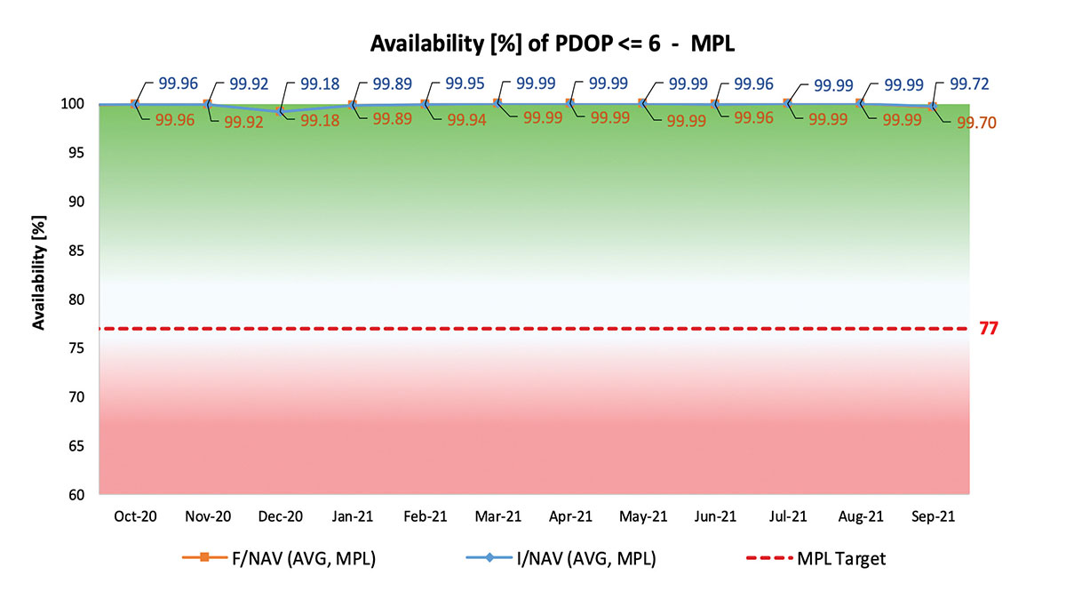
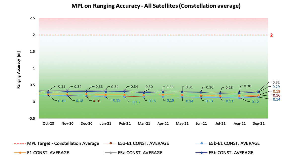
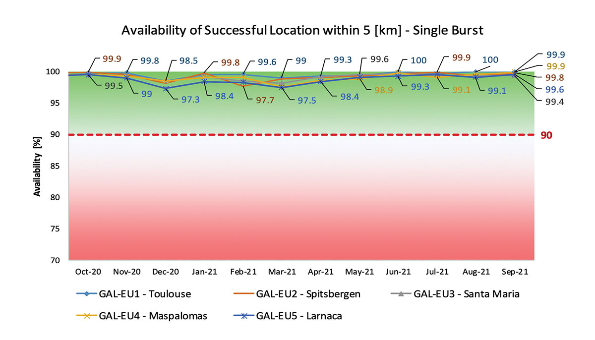
With 22 satellites in service, the open service is already delivering more than 99% availability of PDOP <= 6 worldwide. This, together with the excellent ranging accuracy, suggests that most Galileo dual-frequency users are typically experiencing positioning accuracy in the order of only 2 to 3 meters.
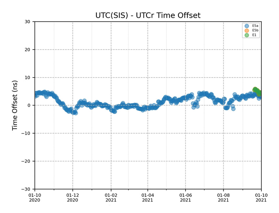
Timing users also continue to receive accurate (in the order of 5 ns) access to Galileo System Time, which they can trace to Universal Coordinated Time (UTC) through the corresponding offset parameters transmitted by the satellites.
The SAR/Galileo service, contributing to COSPAS/SARSAT, continues to deliver both the Forward Link Service (FLS) and the Return Link Service (RLS) with more than 99% availability, allowing users in distress not only to issue an alert and be located within a few minutes, but also be notified that the alert was successfully processed and rescue is on the way. The SAR/Galileo control center is located in Toulouse (France) and operated by CNES under the authority of EUSPA. The excellent performance of the service has been demonstrated both through several rescue exercises and real-life emergencies.
Performance of Galileo positioning services. (Credit: EUSPA)
Performance of Galileo positioning services. (Credit: EUSPA)
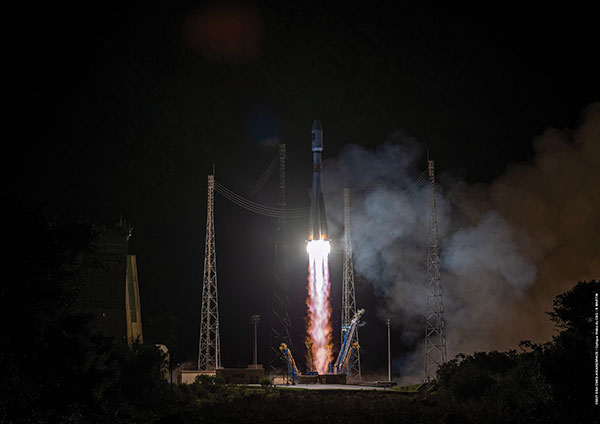
Galileo Launch 11
Soyuz launcher VS-26 lifted off from French Guiana with the first pair of Galileo Batch 3 satellites on Dec. 5, 2021, at 01:19 CET. This marks the 11th Galileo launch of operational satellites in 10 years: a decade of hard work by Europe’s Galileo partners and European industry. With these satellites, the robustness of the constellation has increased, guaranteeing a higher level of service.
Thanks to an upgrade of the Ground Control Segment, the Launch and Early Orbit Phase has been for the first time conducted directly from the Galileo Control Center, rather than requiring an external mission control site. This version of the ground segment increases overall reliability and cybersecurity and opens the way to significant expansion of the Galileo constellation, allowing command and control of up to 38 satellites. The development has been performed by an industrial consortium led by GMV, harnessing state-of-the-art technology using the latest solutions on the market.
Galileo launch 11 from Europe’s spaceport in French Guyana. (Photo: ESA)
On Route to Full Operational Capability
This year will pave the way toward Full Operational Capability of Galileo services.
Industrial prime contractor OHB Systems has nearly completed production of the additional 10 recurrent satellites belonging to Galileo Batch 3. Six of them are undergoing final acceptance testing at the ESA satellite test center, and the other four are under integration at the satellite prime facilities.
Preparation for Launch 12 has already started, with the satellites’ acceptance for a launch date planned in the first months of 2022, followed by Launch 13 in autumn. This is leading toward completion of the Galileo constellation, providing an increased availability of the Galileo signal in space for both GNSS and search-and-rescue users.
Performance of Galileo timing and search-and-rescue services. (Credit: EUSPA)
Performance of Galileo timing and search-and-rescue services. (Credit: EUSPA)
From 2023 onward, the remaining Batch 3 satellites will be launched with the new Ariane 62 launch vehicle, a variant of Ariane 6 with two strap-on solid boosters. The launcher is undergoing the final stages of development, led by prime contractor ArianeGroup.
The Galileo Ground Mission Segment will undergo a complete technological refresh, including hardware virtualization and porting of several million lines of code, performed by an industrial consortium led by Thales France. A series of improvements will be introduced to increase system resilience, including an extended mode of operation to improve service continuity and robustness.
Cybersecurity monitoring of all the ground assets will be introduced as an overlay to the current ground infrastructure. The upgrade will undergo a rigorous level of qualification testing followed by worldwide deployment in a seamless way in both Galileo control centers, in both Galileo security monitoring centers, and at all remote locations without affecting continuity of service.
The service facilities that contribute to the delivery of Galileo services (the European GNSS Service Center, the Galileo Reference Center, and the SAR data service providers) will also evolve to support not only the transition from Initial Services to Full Operational Capability, but also the early roll-out of service evolutions. In this regard, extensive work is ongoing to deliver an exciting set of improvements, some of which are already in development or testing, to reach the users in the year to come:
Improvements of the I/NAV signal to increase robustness and time-to-first-fix, while assuring full backward compatibility with legacy receivers.
OS Navigation Message Authentication (OS-NMA) to support applications that require trust in the authenticity of the data transmitted by the Galileo satellites (a public observation campaign was launched in November 2021 to engage stakeholders and collect their feedback before moving to the initial service provision).
An initial phase of the High Accuracy Service, delivering corrections in the Galileo E6 signal and over terrestrial network to allow users to perform precise point positioning over Europe; test signals were already transmitted with promising results.
A Search and Rescue Beacon Command Service complementing the SAR Return Link, providing improved capabilities to timely locate beacons under authorized emergency situations (such as the disappearance of Flight MH370 in the Indian Ocean in 2014).
A first implementation of an Emergency Warning Service over Europe, allowing the authorized national emergency-management authorities of the EU Member States to relay alert messages through Galileo signals, which can reach target areas even in case of disrupted terrestrial communications (such as due to floods or earthquakes).
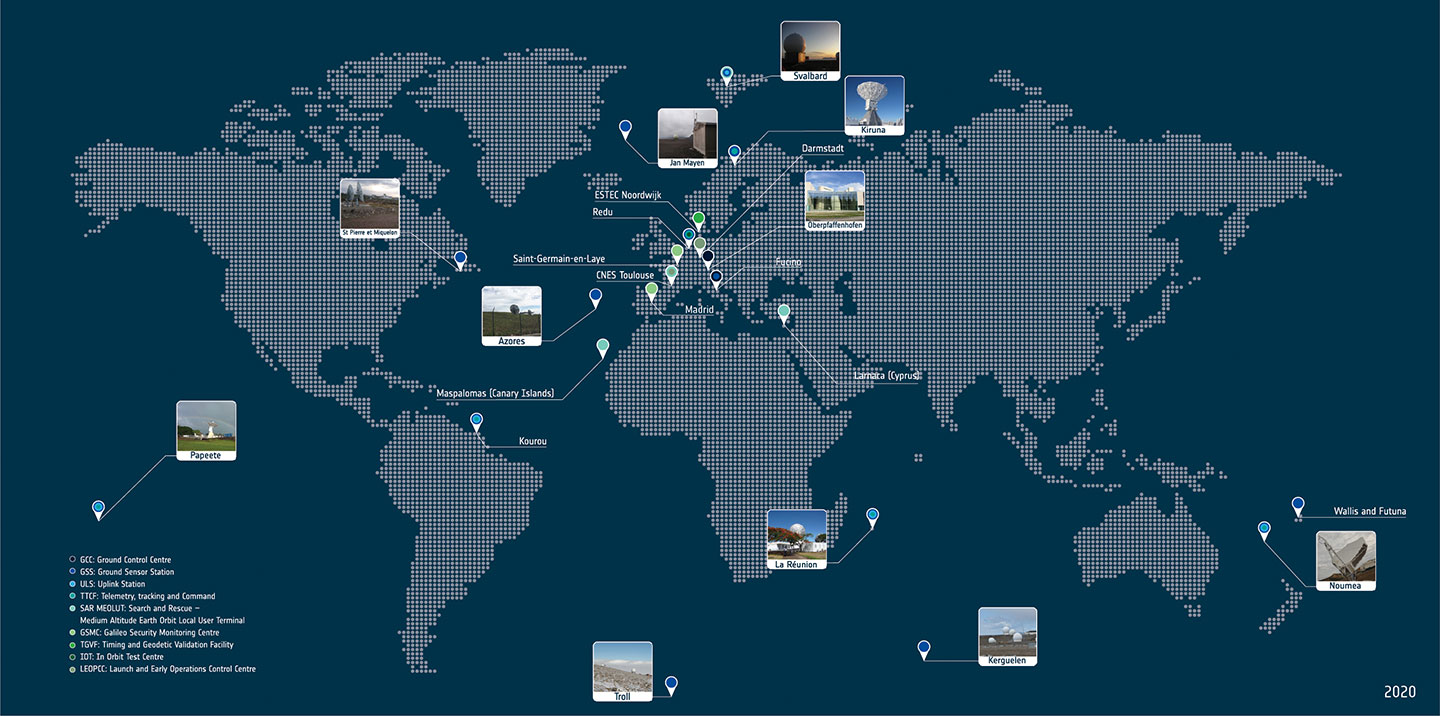
Galileo worldwide ground segment. (Credit: ESA)
Second Generation in the Making
The FFPA will bring Galileo to the next level with the development of the second generation, a further step forward with the use of many innovative technologies to guarantee the system’s unprecedented precision, robustness and flexibility.
In parallel to the completion of the first generation of Galileo, Europe has conducted in recent years preparation activities for the Second Generation (G2). Elaborating on market, user and exploitation needs collected by EUSPA, ESA identified a number of system evolution scenarios, which were discussed among relevant EU stakeholders to select the second-generation mission and services baseline to build the system infrastructure.
The evolution of Galileo capabilities will not only provide better services through advanced technical solutions identified by ESA, but will also ensure continuity of service and backward compatibility for
first-generation legacy users.
Two parallel contracts to develop and manufacture each of the six Galileo Second Generation Batch#1 satellites were kicked off in the first half of 2021 with Thales Alenia Space (Italy) and Airbus Defence & Space (Germany). The new G2 satellites will be constructed on a short time scale, with their first launch via Ariane-62 expected in less than four years, allowing them to commence operations in space as soon as possible. Both contracts have already undergone preliminary design reviews.
Development of the G2 satellites is supported by the Galileo Payload Test Bed, which provides an early proof-of-concept of the advanced G2 payload architecture. These satellites will provide, among others, the following key innovations:
Reconfigurable fully digital navigation payload.
Point-to-point connection between satellites by Inter-Satellite-Link for command and control and ranging functionalities.
Electric propulsion for orbit-raising capabilities.
Advanced jamming and spoofing protection mechanisms to safeguard Galileo signals.
System and Ground Segment definition studies, together with the associated technology pre-developments, have been performed, leading to the definition of the preliminary design and technical requirement baseline for the G2 system, a project involving most of Europe’s space industrial partners.
The G2 In-Orbit Validation Ground Segment and System Test Bed have been defined and relevant procurement procedures are ongoing, with these objectives:
G2 Batch#1 satellites launch and early orbit phase, in-orbit testing and enhanced legacy services provision.
G2 new capabilities in-orbit validation, including prototyping and validation of all the novel technologies that can exploit the full capabilities of the G2 Batch#1 satellites.
Galileo Second Generation Batch#1B satellites. (Image: ESA).
Definition activities for the G2 Initial Orbit Capability (IOC) are progressing well and are expected to converge in the first half of 2022, in order to establish the future roadmap for new G2 services provision in the years to come.
2022 will be a key year for the evolution of Galileo Second Generation activities, through the consolidation of the first batch of G2 satellite design and development activities and the start of development of associated G2G IOV Ground Segment and System Test Beds.
A bright future awaits Galileo, both through the completion of its Final Operational Capability and the start of evolution towards Galileo Second Generation.
Guerric Pont is Galileo Exploitation Program manager for the European Union Agency for the Space Program (EUSPA).
Marco Falcone is Galileo First Generation Project manager for the European Space Agency (ESA).
Miguel Manteiga Bautista is Galileo Second Generation Project manager for the European Space Agency (ESA).
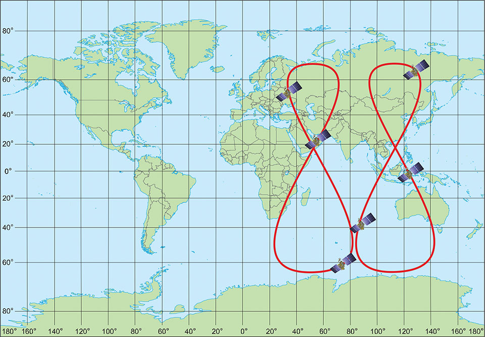
Figure 1. GLONASS high inclined space complex. (Image: Institute of Navigation Technology JSC)
The digital transformation of the global economy requires precise time synchronization and valid object position information. Global navigation satellite systems (GNSS) are the most accurate tool for such tasks.
This year will be 40th anniversary of the launch of the first GLONASS satellite, and we see that the quality of navigation services is driven by the characteristics of today’s satellite navigation signals.
The first fourth-generation Glonass-K2 #13L satellite is scheduled for launch in 2022. It will broadcast a full ensemble of navigation signals — both Frequency Division Multiple Access (FDMA) signals in the L1 and L2 bands and Code Division Multiple Access (CDMA) signals in the L1, L2 and L3 bands. This long-awaited launch will cap a 10-year effort and begin to provide a new platform by broadcasting all the CDMA signals through a single antenna array on the satellite’s geometric axis.
The FDMA antenna array is displaced by 0.9 m from this axis, but this arrangement is done on only two satellites. The next Glonass-K2 satellites, which will be launched beginning in 2024, will have a single antenna array for all navigation signals.
The final second-generation Glonass-M satellite, scheduled to be placed in orbit next year, will provide services by open FDMA signals in the traditional bands at 1.6 GHz and 1.25 GHz. This satellite will be the seventh Glonass-M vehicle able to broadcast GLONASS L3 CDMA signals. There are only two Glonass-K satellites broadcasting this signal now, but more satellites with such a signal will be activated by the end of testing of the GLONASS modernized ground control facility.
We expect the number of satellites able to provide this service to increase by two per year as we replace Glonass-M satellites with Glonass-K and Glonass-K2 satellites.
As of this writing, 15 satellites (62% of the constellation) are working past their guaranteed life times, limiting our ability to increase the system’s accuracy. For the last decade, the signal-in-space range error (SISRE) was 1.4 m, despite the fact that newly launched satellites provide a SISRE of about 0.8 m.
Glonass-K satellites will be launched to maintain the orbit constellation within the next three years, and the accuracy of their signals will be the same or even better. These satellites have a single antenna array for all three bands and could broadcast either FDMA or CDMA signals.
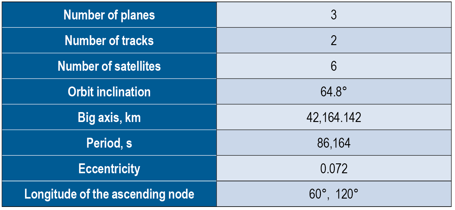
In 2022, the constellation orbits will increase to six satellites in three planes, as we aim to increase the navigation service accuracy and availability (FIGURE 1). See TABLE 1 for satellite orbit parameters. This constellation will make it possible to increase navigation accuracy in the Eastern Hemisphere by about 25% through decreasing the value of the geometric factor.
Additionally, this will greatly improve the availability of the GLONASS navigation service in difficult conditions, such as locations where current users can only receive navigation signals from satellites at least 25° above the horizon. New constellation satellites will be based on the Glonass-K platform, which has passed in-orbit qualification and proved it can provide SISRE at 0.3 m. The preliminary design proved that satellites on this platform could provide an in-orbit SISRE below 0.4 m with standard cesium on-board clocks. This signal-in-space accuracy level with valid ionospheric and tropospheric model data from the navigation signal will allow users to receive a position determination error below 2 m in the plane. Navigation services from these satellites will be provided by the CDMA signal in three frequency bands.
The new satellite will weigh about 1,000 kg and be launched into orbit from both Russian spaceports (northern Plesetsk and eastern Vostochny) by the highly reliable Soyuz-2 rocket. The first launch is scheduled for 2026.
One of GLONASS’ important tasks is to transmit the UTC (SU) national time scale to consumers. Over the past few years, significant results have been achieved in this area.
A complex of high-precision measuring instruments to compare the national coordinate timescale UTC (SU) with the GLONASS timescale was put into operation. These instruments include a transported quantum clock that provides timescale storage with an uncertainty of no more than 1 ns at an observation interval of one day, and with a transportation time of no more than 12 hours. It also provides duplex comparisons of timescales, comparing objects with the permissible uncertainty of ±1.5 ns.
Timescale storage complexes of secondary and working standards of time and frequency VET1-5 (Irkutsk), VET 1–19 (Novosibirsk), VET 1–7 (Khabarovsk) and RET1-1 (Petropavlovsk-Kamchatsky) were modernized and put into operation, providing an overall uncertainty of 3 · 10-15 and with a maximum permissible shift of the timescale of the complex relative to the national timescale UTC (SU) of ± 10 ns.
An optical ground-based frequency reference on cold strontium atoms was developed with an uncertainty of reproduction of the frequency unit and time of no more than 1 · 10-17 .
A keeper of time and frequency units was developed on the basis of a “fountain” of rubidium atoms having a frequency instability of no more than 2 · 10-16 for equipping the standards of time and frequency units and subsequent transmission of more accurate time-frequency information to precision ground and onboard equipment and GLONASS systems.
A developmental prototype of the national timescale storage complex of the Russian Federation was developed on the basis of a new generation of hydrogen keepers.
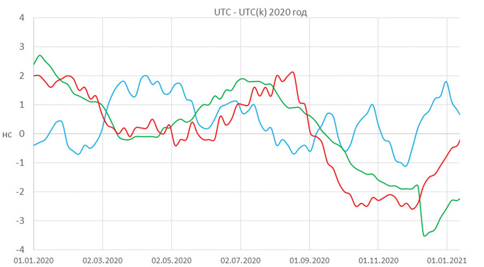
The application of the newly developed technical equipment made it possible to significantly reduce the maximum displacement of the national timescale relative to the International Coordinated Time Scale (UTC), which in 2020 was less than ± 3 ns (FIGURE 2). The UTC (SU) timescale ranks among the best national implementations of UTC, according to the International Bureau of Weights and Measures (BIMP).
Figure 2. Displacement of national timescales relative to Universal Coordinated Time (UTC). (Image: VNIIFTRI FSUE)
Many important events are coming for GLONASS users in 2022. They will improve the user characteristics and lay the foundation for further development of the system.
Sergey Karutin is general designer of the Russian GNSS program GLONASS.
Nicolay Testoedov is CEO of JSC Information Satellite Systems Reshetnev (ISS JSC), a Russian satellite manufacturing company.
Sergey Donchenko is general director of the Federal State Unitary Enterprise, Russian metrological institute of technical physics and radio engineering, VNIIFTRI FSUE.
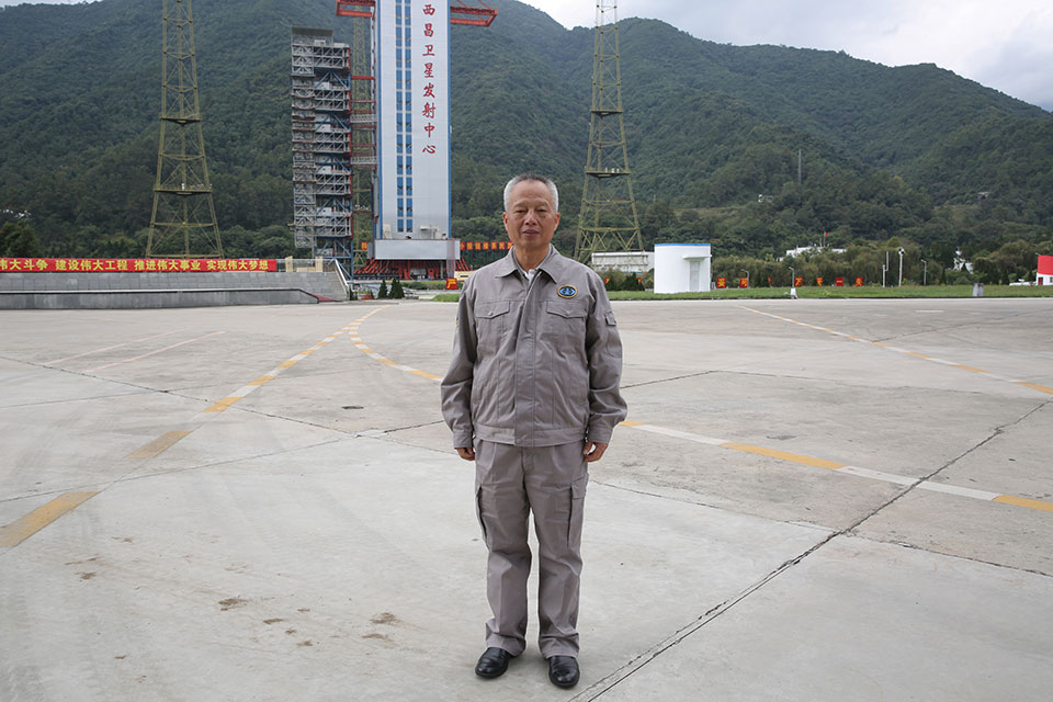
Yang Changfeng is BeiDou’s Chief Architect. (Photo: BeiDou Navigation Satellite System)
Construction of the BeiDou Navigation Satellite System (BDS-3) has been completed. The system was formally commissioned on July 31, 2020. In 2021, BDS continued to improve performance, expand applications and deepen cooperation, and has achieved sustained, stable and rapid development.
System Performance and Services
Currently, 45 BDS satellites are operational in orbit — 15 BDS-2 satellites and 30 BDS-3 satellites jointly provide seven types of services to users. Specifically, for the entire planet, the system provides three services:
Positioning, navigation and timing (PNT).
Global short-message communication.
International search-and-rescue (SAR) services.
For the Asia-Pacific region, the system provides four additional services:
Satellite-based augmentation.
Ground-based augmentation.
Precise point positioning.
Regional short-message communication services.
The system has been operating continuously and stably since commissioning, with the average value of satellite availability better than 0.99 and the average value of satellite continuity better than 0.999.
PNT Service. As actually measured by the International GNSS Monitoring and Assessment System (iGMAS), the global horizontal positioning accuracy is about 1.52 meters, the vertical positioning accuracy is about 2.64 meters (B1C signal single frequency, 95% confidence), the velocity measurement accuracy is better than 0.1 m/s, and timing accuracy is better than 20 nanoseconds. The performance is better in the Asia-Pacific region.
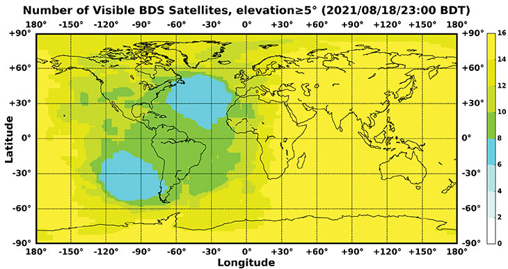
FIGURE 1 shows the number of visible BDS satellites worldwide at BDT 00:00 on Nov. 18, 2021. Among them, the number of visible BDS satellites exceeds 20 in some areas of the Asia-Pacific region.
Figure 1. Number of visible BDS satellites, elevation ≥5° (2021/11/18/00:00 BDT). (CREDIT: www.csno-tarc.cn)
Global Short Message Communication Service. Trial service is provided through 14 medium-Earth-orbit (MEO) satellites for authorized users and low-orbit satellites, with a maximum single-message length of 560 bits, equivalent to about 40 Chinese characters.
Search-and-Rescue Service. A COSPAS/SARSAT-compliant MEOSAR service is provided by six payloads deployed on six MEO satellites. A B2b signal-based Return Link Service (RLS) is provided through 24 MEO and three IGSO satellites, which have completed testing and verification and are in the process of coordination within the framework of COSPAS-SARSAT.
Satellite-Based Augmentation Service. China’s Civil Aviation Administration is organizing satellite-ground integrated test and evaluation, and the positioning accuracy, alarm time, integrity risk and other indicators meet the requirements.
Ground-Based Augmentation Service. Real-time centimeter-level and post-processing millimeter-level services are provided for industrial and public users, based on the regional network reference stations built in China.
Precise Point Positioning Service. PPP signals are broadcast by three GEO satellites. The measured horizontal positioning accuracy is 0.24 m, the vertical positioning accuracy is 0.41 m (95% confidence), and the convergence time is less than 20 minutes.
Regional Short Message Communication Service. The short-message communication function has been tested and verified for integration into public mobile phones; large-scale application is planned.
Development of the Applications Industry
Large-scale applications of BDS have entered a critical stage of liberalization, industrialization and internationalization. The overall output value of China’s satellite navigation and location-based service industry continued to grow in 2020, up to 403.3 billion yuan (US$63.2 billion), which is about 16.9% more than its value in 2019. In terms of BDS-3-enabled basic products, an industrial chain is gradually maturing, comprised of BDS/GNSS basic chips, modules, boards, antennas and other components.
The certification and testing system of basic BDS products has been established and implemented. BDS is already supported by most mainstream chips. BDS is increasingly being integrated into the daily life of the general public. It is becoming the standard configuration for positioning functions of smartphones and other mass-market products.
Smartphone manufacturers such as Xiaomi, Huawei, Apple and Samsung already support BDS. In the first three quarters of 2021, among all types of smartphones applying for online access in China, 72.3% supported positioning function based on BDS, accounting for 93.5% of the total sales volume. The BDS ground-based augmentation function has been introduced into smartphones to achieve high-precision positioning at the 1-meter level; lane-level navigation is being piloted in several cities in China.
In terms of industrial applications, BDS has fully served multiple industries including transportation, public security, disaster relief, agriculture, forestry, animal husbandry and fishing. It has accelerated the integration into electricity, finance, communications and other infrastructure. In particular, in the fight against COVID-19 through scientific and technological approaches, BDS-based precise positioning has facilitated the efficient supply and circulation of anti-epidemic materials.
BDS-based solutions for land rights determination, precision agriculture and smart ports have served the economic and social development of countries in Asia, Eastern Europe and Africa, and BDS-based products have been applied in more than half of the world’s countries and regions.
International Cooperation
BDS has always adhered to the development concepts of openness, cooperation and resource sharing; actively carried out practical international exchanges and cooperation; and contributed to China’s peaceful use of outer space.
Bilaterally, the Eighth Meeting of the China-Russia Project Committee on Major Strategic Cooperation in Satellite Navigation was held in October 2021. Both sides jointly formulated and signed the Roadmap for Cooperation in the Field of Satellite Navigation from 2021 to 2025, providing planning and guidance for China-Russia satellite navigation cooperation in the next five years. Also, China’s Satellite Navigation Office signed a memorandum of understanding on satellite navigation cooperation with the National Committee on Space Activities of the Republic of Argentina and the South African National Space Agency, and formally established a regular cooperation mechanism.
BDS is gradually being integrated into international standards, and is steadily promoting ratification by international standards bodies, including in the civil aviation, maritime, SAR, mobile communications and electrotechnical fields. Several international standards supporting BDS have been released. The Chinese government has drafted a letter of commitment to the International Civil Aviation Organization (ICAO), stating that BDS will provide basic services free of charge to civil aviation users around the world. The International Association of Marine Aids to Navigation and Lighthouse Authorities (IALA) has officially issued a standard that ratifies BDSBAS, so that global marine users can carry out applications based on it. The Third Generation Partnership Project has started the standardization of BDS-3’s B2a and B3I signals. In the detection standard for Indicating Radio Beacon Locator of the Global Maritime Distress and Safety System issued by the International Electrotechnical Commission, BDS receivers and BDS-based SAR services will be supported.
The Chinese government is steadily advancing the rule of law, attaching great importance to and comprehensively promoting the rule of law for satellite navigation. A legal system on BDS has been formed, consisting of national policies, industrial and local policies and regulations, and more. The legislative process of the Satellite Navigation Regulations of the People’s Republic of China has been actively promoted to ensure the healthy, rapid and sustainable development of the satellite industry. In May 2021, China issued a development report on the rule of law of BDS.
Follow-Up Plan
In the future, on the one hand BDS will ensure stable operation, while on the other hand it will focus on the development of backup satellites, and complete the production, state optimization and ground testing of backup satellites. Backup BDS-3 satellites with better performance will be launched as needed to further improve the reliability of the constellation. By adhering to the development concept of “BDS is developed by China, dedicated to the world and aiming to be first class,” carrying forward the BDS spirit of the new era of “independent innovation, open integration, unity of all, pursuit of excellence,” BDS will serve the world and benefit all humankind.
Number of BDS-3 satellites in orbit: 30
Signals broadcast: B1I, B3I, B1C, B2a, and B2b
Yang Changfeng is chief architect of the BeiDou Navigation Satellite System and a Chinese Academy of Engineering academician.
By Francesco Ardizzon, Nicola Laurenti, Carlo Sarto and Giovanni Gamba
To ensure the authenticity of the Galileo navigation messages, the Open Service navigation message authentication (OSNMA) mechanism requires a loose synchronization between the receiver clock and the system time.
To ensure the authenticity and the integrity of the transmitted messages, the Timed Efficient Stream Loss-tolerant Authentication (TESLA) protocol for broadcast authentication requires a loose time synchronization between the transmitter and the receiver — that is, an upper bound to the time offset between their clocks. In the context of the TESLA-based Open Service navigation message authentication (OSNMA) protocol, it is customary to assume that:
On the system side, the transmission is synchronous because the satellites are equipped with high-precision atomic clocks, the drift of which is assumed negligible with respect to those at the receiver side.
At the receiver side, commercial clocks can be found that are less accurate and less stable, which accounts for the substantial time mismatch between the transmitter and the receiver clocks accumulating over time.
To limit the impact of such mismatch on OSNMA operation, it is envisioned that clocks for authenticated tachographs onboard vehicles, such as the ones that will be employed for the position authenticated tachograph for OSNMA launch (PATROL) project, are reset and precisely realigned to system time in periodic workshop visits. However, the clock mismatch must satisfy the OSNMA constraint at all times between successive workshop resets, in the “holdover” period, and through all possible operating conditions, to ensure constant authenticity of the navigation message.
In other contexts, this task is performed by such means as network synchronization protocols.
However, we are considering a scenario where, during holdover, we cannot rely on other sources, such as an internet connection or other devices to synchronize with the reference time to assure the authenticity of our time reference and, consequently, of the PVT solution. We also cannot trust any signal received during the holdover period, thus we should not use the PVT solution to synchronize the clock.
Here, we have two goals. First, investigate the causes of the misalignment and frequency deviation in clock generators commonly found on the market for GNSS receivers. Second, relate the clock specification parameters, taken directly from the real-time clock (RTC) device datasheets, the holdover period, and the OSNMA misalignment constraints.
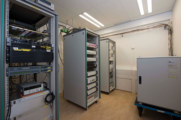
Atomic clocks at ESTEC’s Navigation Laboratory in The Netherlands independently validate Galileo timing performance. (Photo: ESA)
Frequency Accuracy and Stability
Two metrics are usually employed to evaluate the performance of an oscillator.
Clock frequency accuracy is the normalized difference between the frequency output and its nominal value, f0.
Clock frequency stability is the normalized instantaneous frequency deviation from its local mean.
Although devices are characterized in terms of their stability, we are interested in measuring their accuracy y(t)ΔF(t)⁄f0, where ΔF(t) is the instantaneous frequency deviation from f0 at time t. The calibration performed during each workshop reset brings the residual misalignment to a negligible value called phase calibration error. On the other hand, we will later discuss the residual frequency deviation, due to the frequency calibration error.
The loose time synchronization requirement TL states that the authenticity of the navigation message received at time t is guaranteed if |ΔT(t)|≤TL, at every t during the holdover period.
Finally, we can relate accuracy and misalignment using the bound
(1)
which allows us to upper bound the clock misalignment at any time t in terms of the frequency accuracy along the whole interval elapsed from the last calibration time t0.
Accuracy Loss for Receiver Clocks
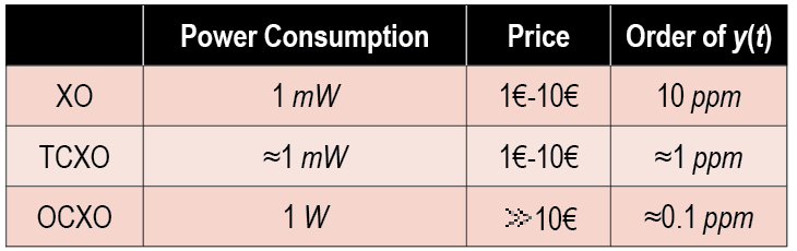
Thanks to their affordable price and wide temperature operating conditions, quartz crystal oscillators are used for clock generation in GNSS receivers (see TABLE 1). We distinguish among simple, temperature-controlled crystal oscillators (TCXOs) and oven-controlled crystal oscillators (OCXOs). GNSS receivers typically employ TXCOs because they offer the best trade-off in terms of power consumption, price and typical accuracy.
Table 1. Summary of the main quartz crystal oscillator characteristics.
Sources of Frequency Accuracy Loss. Quartz crystals are piezoelectric materials, therefore any additional stresses and environmental changes generate an additional voltage, decreasing the clock stability. In the automotive scenario, the main sources of accuracy loss are temperature changes, long-term aging, and the residual calibration frequency offset, while the impact of accelerations, vibrations, gravity variation and supply voltage oscillation can safely be neglected as they result in changes of a few parts per billion.
Currently, no analytic relationship is known between frequency accuracy and temperature for TCXOs (or OCXOs). Therefore, as reported in datasheets, the inaccuracy induced by the temperature changes is bounded by a constant value Ytemp across the whole operating temperature range. This yields a bound on the clock misalignment that increases linearly with the time from the last calibration.
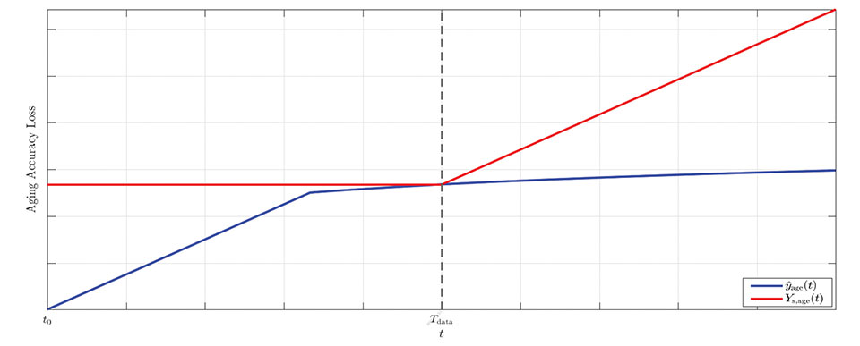
Long-term aging has significant impacts on the clock frequency accuracy and may affect the device even when it is not used for a long time (see Figure 1). A critical aspect of this effect is that it is time-variant, with the accuracy loss increasing over time.
Figure 1. Graphical representation of the model for aging accuracy loss: upper-bound (red) versus estimated model (blue). (Image: R. Filler and J. Vig)
However, datasheets typically report a single value, Yage (Tdata ), which bounds the accuracy at a fixed time Tdata.
The effect of long-term aging for both TCXOs and OCXOs was investigated in a 1993 study by R. Filler and J. Vig measuring the accuracies of oscillator models for several years. The study concluded that a logarithmic fit is better suited for long-term measurements, while a linear fit is better suited for initial measurements (t<30 days) and is a loose upper-bound for longer times. Because we are interested in establishing a prudential upper bound rather than a precise estimate, we use the constant upper bound Yage (Tdata) for all t<Tdata and a linear upper bound for t>Tdata. This leads to a linearly increasing bound on the time offset before Tdata, and a quadratically increasing bound after Tdata.
Finally, the misalignment due to the frequency calibration error accumulates over time. An off-the-shelf oscillator has an initial accuracy that depends on the frequency tolerance ftol. To improve this, a precise calibration is performed, trying to synchronize the RTC with the nominal frequency f0, such as by using PTP. The contribution to the accuracy loss given by calibration can be bounded by Ycalib, a value set a priori either by system design or during the calibration process itself, yielding again a linearly increasing bound on the clock misalignment.
Bound on the Total Misalignment. In general, the cross-correlation between the uncertainties is unknown; we can only consider the worst-case scenario where the total uncertainty is bounded by the sum of the single bounds. This choice represents a prudential and conservative approach that may yield a rather loose bound with very high probability.
Thus, considering that all terms in the clock error bound increase over time, we can bound the total misalignment as
(2)
Example Values from Datasheet Specifications
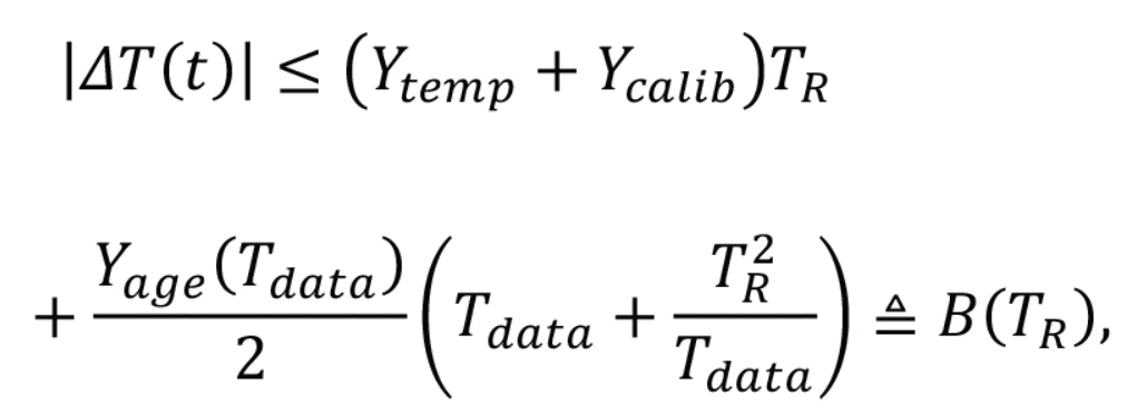
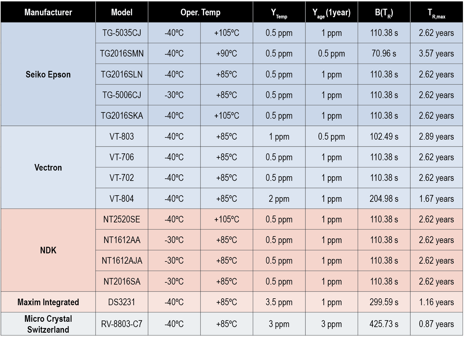
Based on the above result, we can deem a commercial oscillator suitable for OSNMA operation if B(TR )≤TL. We can then compare the requirements for different RTCs, focusing on TCXOs designed for GNSS receivers suitable for the automotive scenario, with f0=52 MHz and a target operating temperature range between –20° Celsius and +85° Celsius. We assume that devices are subject to a calibration process, such that YcalibYtemp; thus we have neglected the calibration accuracy loss. We report in Table 2 the values of the misalignment bound, B(TR ), for TR=2 years and the maximum reset period TR,max such that B(TR,max)≤TL, with a loose time synchronization requirement TL=165s, as computed form the specs found in the datasheets.
Table 2. Bound values B(TR) and TR,max computed using several RTCs’ datasheet specs with TL=165 s and TR=2 years.
Conclusions
To ensure the authenticity of the GNSS navigation message, the Galileo OSNMA protocol requires a loose synchronization between the transmitter and the receiver. The misalignment between transmitter and receiver clock needs to be lower than a threshold TL for the whole holdover period TR. In this article, we have investigated the causes of the misalignment and frequency deviation in clock generators commonly found on the market and defined a general relationship between TL ,TR and the specifications commonly found in datasheets. Finally, we examined several mass-market temperature-controlled crystal oscillator datasheets, evaluating their performance in terms of worst-case offset bound B(TR).
The bound represents a prudential conservative approach and may be rather loose. However, given the lack of a consistent statistical model, this is a reasonable solution. We conclude that most devices can satisfy the constraint B(TR)≤TL=165 s with a workshop reset period of TR = 2 years.
Acknowledgements
This study was conceived within the PATROL (Position Authenticated Tachograph foR OSNMA Launch) project, funded by the EU Agency for the Space Programme through the Fundamental Elements programme, under procurement No. GSA/OP/23/16 “Development, supply and testing of a Galileo open service authentication user terminal (OSNMA) for the GSA.”
The authors acknowledge the invaluable support provided by the PATROL technical team: Davide Marcantonio (Qascom), Fabio Pisoni, Giovanni Gogliettino and Domenico di Grazia (ST Microelectronics), Alexandre Allien and Francois Riou (FDC), Jacques Kunegel (ACTIA), Simón Cancela Díaz and Belén Villanueva Coello (GMV).
PATROL success was fostered by the commitment and support of Flavio Sbardellati (EUSPA Project Officer), Gonzalo Seco Granados and Alexander Rügamer (EUSPA external reviewers), Javier Simon (EUSPA reviewer), Ignacio Fernandez-Hernandez and Giovanni Vecchione (EC reviewers). The authors thank colleagues Giada Giorgi (UNIPD) and Lorenzo Dal Corso (Qascom) for reviewing this work.
The content of this publication does not reflect the official opinion of the European Union or of the EU Agency for the Space Programme. Responsibility for the information and views expressed therein lies entirely with the authors.
Francesco Ardizzon is a Ph.D. student and Nicola Laurenti an associate professor in the Department of Information Engineering of the University of Padova, Italy. Carlo Sarto is the head of the security engineering division and Giovanni Gamba the head of the SIGINT and EW division at Qascom S.r.l., in Bassano del Grappa, Italy.
REFERENCES
A. Perrig, R. Canetti, J. Tygar, and D. Song, “The TESLA broadcast authentication protocol,” RSA CryptoBytes, vol. 5, 11 2002.
I. Fernandez-Hernandez, T. Walter, A. Neish, and C. O’Driscoll, “Independent time synchronization for resilient GNSS receivers,” in 2020 International Technical Meeting of The Institute of Navigation, 02 2020, pp. 964–978.
I. Fernandez-Hernandez, V. Rijmen, G. Seco-Granados, J. Simon, I. Rodriguez, and J. D. Calle, “A Navigation Message Authentication proposal for the Galileo Open Service,” NAVIGATION, vol. 63, no. 1, pp. 85–102, 2016. [Online]. Available: https://onlinelibrary.wiley.com/doi/abs/10.1002/navi.125
L. Cucchi, S. Damy, M. Paonni, M. Nicola, M. Troglia Gamba, B. Motella, and I. Fernandez-Hernandez, “Assessing galileo OSNMA under different user environments by means of a multi-purpose test bench, including a software-defined GNSS receiver,” in 4th International Technical Meeting of the Satellite Division of The Institute of Navigation (ION GNSS+ 2021), 9 2021.
“IEEE standard definitions of physical quantities for fundamental frequency and time metrology—random instabilities,” IEEE Std 1139-2008, pp. c1–35, 2009.
J. Vig, “Quartz crystal resonators and oscillators for frequency control and timing applications – a tutorial,” in IEEE International Frequency Control Symposium Tutorials, 2016.
M. Lombardi, “Fundamentals of time and frequency,” in The Mechatronics Handbook, CRC Press, 01 2002, ch. 17.
R. Filler and J. Vig, “Long-term aging of oscillators,” IEEE Transactions on Ultrasonics, Ferroelectrics, and Frequency Control, vol. 40, no. 4, pp. 387–394, 1993.
W. Riley and D. Howe, Handbook of Frequency and Stability Analysis. Special Publication (NIST SP), National Institute of Standards and Technology, Gaithersburg, MD, 2008-07-01 00:07:00 2008.
“Performance specification: oscillator, crystal controlled, general specification for,” MIL-PRF-55310F, 2018.
Arianespace will launch eight additional Galileo satellites, confirmed the European Union Agency for the Space Programme (EUSPA).
Arianespace will launch the first two satellites in 2022, leading to the Full Operational Capability of Galileo open service. Then, three successive launches on Ariane 62 in 2023, 2024 and 2025 will finalize the launch of the first generation of Galileo satellites and will increase the constellation resilience.
These will be the 13th to 16th Galileo missions by Arianespace, which has orbited all satellites in the constellation.
With this order, EUSPA takes over the role of placing launch services contracts for Galileo from the European Space Agency (ESA), which has acted so far in the name and on behalf of the European Commission and will continue to be the technical authority for these launches.
The order follows ESA’s order for the launch of four satellites in October 2021, and will complete the deployment of first-generation Galileo satellites.
The launches will take place from the Guiana Space Center, Europe’s Spaceport in Kourou, French Guiana. After a Galileo launch in the first half of this year, carrying satellites from a previous order, a second Soyuz launch this year will orbit the first two satellites from this latest order. The next three missions will orbit two satellites each on Ariane 62.
“I would like to thank ESA and EUSPA, along with the European Commission, for continuing to entrust us with their satellites,” said Stéphane Israël, CEO of Arianespace. “We’re very proud to once again be helping the EU deploy its own global navigation satellite system. This additional order to the service of Galileo once again confirms Arianespace’s assigned mission of ensuring reliable access to space for Europe.”
Each of the eight satellites under this order, built by OHB System AG in Bremen, Germany, will weigh less than 730 kg. They will join the 28 Galileo satellites already deployed to date, as well as the two to be orbited in early 2022 from the Guiana Space Center by Arianespace.
The Galileo Open Service Definition Document (OS SDD) was updated to reflect upgrades in the Galileo system since the publication of the previous version in May 2019. The latest version, 1.2, can be found on the GSC web portal.
This is the last update foreseen before Galileo Open Service reaches Full Operational Capability (FOC).
The SDD has been updated to include improvements of the Open Service, accounting for the current constellation and updates in the ground infrastructure that increase its robustness.
The updated SDD provides better minimum performance levels (MPLs) for signal and position availability and updated definitions of some timing MPLs. It also establishes a more stringent commitment on the time to publish Notice Advisories to Galileo Users (NAGUs). In addition, the concept of auxiliary satellites has been added, while some sections have been reworded to improve clarity.
The Global Positioning System (GPS) is “still a significant single point of failure in our country,” said Caitlin Durkovich, National Security Council director for Response and Resilience.
Her remarks were made at the Dec. 9 meeting of the president’s National Space-based Positioning, Navigation and Timing (PNT) Advisory Board.
Durkovich’s remarks were made in the context of a larger national resilience message. She cited recent incidents such as Hurricane Ida, the Colonial Pipeline hack, the winter failure of the Texas electrical grid, and disrupted supply chains. She said everyone is responsible to ensure they, their systems and the nation are able to safely weather adverse events and bounce back better than before.
The interconnectedness of so many vital services such as electrical power and other vital systems like PNT make a holistic approach necessary. The administration is developing a set of resilience principles to support that, she said. It is also ensuring as funds go out to states and localities from the infrastructure bill that making American infrastructure more resilient to climate change and “all hazards” is a priority.
Because “positioning, navigation and timing is foundational to our life,” she said, “resilience is more important now than ever.” Disruptions could lead to “cascading effects.”
Durkovich cited the administration’s Space Priorities Framework as evidence of White House concern. Released this month, it says in part:
“Space systems are an essential component of U.S. critical infrastructure — by directly providing important services and by enabling other critical infrastructure sectors and industries. The United States will enhance the security and resilience of space systems that provide or support U.S. critical infrastructure from malicious activities and natural hazards.”
She also indicated that the Biden administration was following through on two Trump administration policies as important steps to resilience.
Executive Order 13905, “Strengthening National Resilience Through Responsible Use of Positioning, Navigation, and Timing Services,” among other things, calls on all users to avoid over-reliance on GPS. It also calls for the federal government to require PNT resilience to be considered when selecting contractors.
Space Policy Directive 7 “The United States Space-Based Positioning, Navigation, and Timing Policy” outlines a number of research and other efforts. It also says the nation will:
“Invest in domestic capabilities and support international activities to detect, mitigate, and increase resilience to harmful disruption or manipulation of GPS, and identify and implement, as appropriate, alternative sources of PNT for critical infrastructure, key resources, and mission-essential functions.”
Several board members asked about the Federal Communications Commission’s (FCC) order authorizing Ligado Networks to broadcast in frequencies adjacent to those used by GPS. She said the administration was concerned and both the National Economic Council and National Security Council were in discussion. Engagement with the FCC, though, may pend confirmation of a full board of commissioners.
One of the board members asking about the Ligado issue followed up with a comment that adjacent-band concerns pale in comparison to recent Russian threats to GPS satellites. Durkovich responded that there wasn’t much she could say on that topic in public except that it had the attention of the president and his senior advisors.
Durkovich was also asked about the administration’s commitment to execute the 2018 National Timing Resilience and Security Act. The law’s requirement to establish a terrestrial, wireless source of coordinated universal time to back up GPS signals by December 2020 was ignored by the Trump administration.
Her reply was to reaffirm her earlier statement that “assuring positioning, navigation and timing, and the economic and strategic benefits it brings to this nation, is a priority for this administration.”
Video of the entire advisory board meeting is available on YouTube. MS Durkovich’s remarks begin at approximately 1:37:00. A link to the video is also posted as part of the agenda on the board’s website.
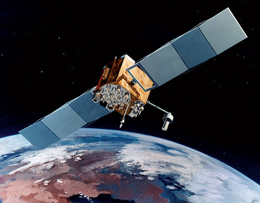
Artist’s rendering of GPS IIF satellite. (Image: U.S. Air Force )
Boeing has secured a 10-year, $329.3 million contract to help the U.S. Space Force engineer operational GPS Block IIF satellites, the Department of Defense announced Dec. 20.
The company will perform engineering work to support on-orbit operations of the Block IIF satellites, which were manufactured by Boeing.
Space Systems Command issued the indefinite-delivery/indefinite-quantity contract to address GPS IIF mission requirements across the military and expects work to conclude by Dec. 20, 2031.
The U.S. Air Force deployed the first Boeing-built IIF satellite in May 2010 and launched the 12th and final satellite in February 2016.
An Info Note has been published with analytical information on the Galileo Open Service – Navigation Message Authentication (OSNMA). The note is available on the European Union Agency for the Space Programme (EUSPA) website or through the European GNSS Service Centre. To contribute to the detection of GNSS jamming and spoofing attacks, EUSPA together with the European Commission is testing OSNMA.
This forthcoming service is an authentication mechanism that allows Open Service users to verify the authenticity of GNSS information, making sure that the data they receive is indeed from Galileo and has not been modified in any way.
OSNMA is authenticating data for geolocation information from the Open Service through the Navigation Message (I/NAV) broadcast on the E1-B signal component. This is realized by transmitting authentication-specific data in previously reserved fields of the E1 I/NAV message. By using these previously reserved fields, OSNMA does not introduce any overlay to the system, thus the OS navigation performance remains untouched.
Authentication is set to further strengthen service robustness by increasing the capability of detecting spoofing events. However, it should be kept in mind that authentication does not prevent the occurrence of such an event, and does not protect against jamming. Nonetheless, this added layer of protection proposes to be one step ahead of evolving technological trends by amplifying the service’s overall robustness and resilience.
The Air Force Research Laboratory’s complementary positioning, navigation and timing (PNT) AgilePod prototype achieved three important objectives in flight tests conducted at Edwards Air Force Base Nov. 1-10, 2021.
PNT AgilePod helps develop advanced navigation technology independent of GPS, according to Maj. Andrew Cottle, Air Force Strategic Development Planning and Experimentation (SDPE) office. This technology provides reliable, resilient PNT navigation signals through alternative means, increasing mission effectiveness in scenarios where access to GPS is not guaranteed.
The test team — representing a broad base of Air Force, Navy and vendor organizations — successfully executed eight sorties aboard a T-38C aircraft, which included:
the first test of the PNT AgilePod on a high-dynamic-range platform
the first test of fully remote interfacing and alt-PNT data transmission
the first demonstration of overland/overwater transition performance.
He said the tests demonstrated the operational utility of a fused alt-PNT system incorporating multiple technologies within a single government-owned open-architecture prototype.
A PNT AgilePod attached to a T-38C successfully demonstrated remote interfacing and alt-PNT data transmission, as well as performance over land and water. (Photo: USAF/2nd Lt. Bowen Lin, 586th Flight Test Squadron)
AgilePods Designed for Flexibility
AgilePods are comprised of a series of compartments and can be configured to meet a wide variety of mission requirements for many aircraft platforms. Experimenters can fill the spaces with plug-and-play sensors they need for a mission — high-definition video, electro-optical and infrared sensors, and devices with other capabilities — including PNT.
The AgilePod has an open hardware architecture. For the complementary PNT prototype, it was combined with an open software architecture that allows a wide variety of alternative PNT technology to integrate and pass information. These capabilities enable rapid integration of sensor technologies through standardized software and hardware interfaces, allowing the pod to seamlessly integrate on platforms that leverage the standard architectures.
In this way, one pod can perform hundreds of different mission sets with additional benefits of cost savings and increased sustainability, Cottle said.
The project directly supports the AFRL PNT Enterprise and the Air Force PNT Cross-Functional Team as they work to ensure reliable navigation within GPS-contested operational scenarios critical to the success of future Air and Space Force missions.
A PNT AgilePod attached to a T-38C successfully demonstrated remote interfacing and alt-PNT data transmission, as well as performance over land and water. (Photo: USAF/2nd Lt. Bowen Lin, 586th Flight Test Squadron)
 The RINEX Working Group of the International GNSS Service (IGS) has made RINEX 4.00 available on the IGS website.