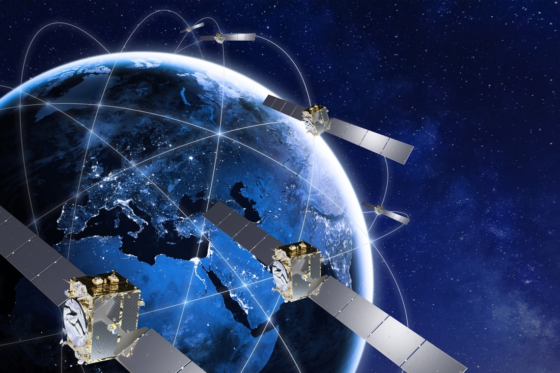
SoftBank Corp., ALES Corp. and u-blox AG have signed a memorandum of understanding to cooperate in GNSS augmentation services for global markets.
SoftBank provides the “ichimill” GNSS augmentation service in Japan, its subsidiary ALES operates a business that generates and delivers positioning correction data, and u-blox is a global provider of positioning services for the automotive, industrial and consumer markets.
U-blox also provides electronic components for wireless communications and the PointPerfect GNSS augmentation service in Europe, the United States and other countries and regions.
Through this business collaboration, SoftBank, ALES and u-blox will construct GNSS augmentation infrastructure for Japan, Europe and the United States, develop GNSS receivers and devices, and expand service areas.
Collaboration Background
Since November 2019, SoftBank has been offering ichimill, a GNSS augmentation service that offers highly accurate positioning with a margin of error of a few centimeters in the Japan market. In addition to providing technology that enables the generation and delivery of correction data, ALES has been offering a centimeter-level positioning service to consumers in Japan since August 2020.
In July 2021, u-blox began providing PointPerfect, a PPP-RTK-based GNSS augmentation service, which is now available in the contiguous United States and Europe.
GNSS augmentation services like these are mainly offered separately by country and region. Client companies, which include global automotive manufacturers and agricultural machinery manufacturers, sign up for separate service contracts in each country and region, making GNSS receiver configuration more complex.
Collaboration Overview
To offer global GNSS augmentation services, SoftBank, ALES and u-blox will study the following initiatives.
Develop a global correction data delivery infrastructure. GNSS augmentation services use correction methods that differ by country and region, and there is a wide variety of correction signal formats. In 2022, the three companies will consider developing a correction data delivery infrastructure that delivers unified correction signal formats for use in any country or region. With this infrastructure, companies using ichimill or PointPerfect will be able to conduct GNSS augmentation if they are in range of both services, which will eliminate the need for separate service contracts by country or region.
Jointly develop global-compatible devices. In addition to correction data delivery, an environment that allows for the easy implementation of GNSS receivers and other devices is necessary for GNSS augmentation services. In conjunction with the launch of ichimill, SoftBank developed its own GNSS receivers and is offering them in Japan. The three companies will consider jointly developing GNSS receivers and modules that can be used globally.
Greater GNSS augmentation accuracy and service area expansion. The companies will collaborate closely to ensure that the performance of the services in all the regions covered are comparable. This is important to provide a consistent customer experience across all regions. Furthermore, the three companies plan to study service expansion into other areas, including Asia. SoftBank is promoting the deployment of non-terrestrial network (NTN) solutions that encompass satellite- and stratospheric-based telecommunication platforms to provide connectivity to the sea, the sky, developing countries and rural areas lacking internet infrastructure so everyone around the world has access to the internet. The three companies will consider the development of NTN-linked services, such as correction data delivery using small amounts of data in a way that is suitable for NTN bandwidths.
The AMRO 2021 exercise tested the rescue of 200 cruise-ship passengers using Galileo SAR. (Photo: EUSPA)
News from the European Union Agency for the Space Programme (EUSPA)
In freezing arctic waters 60 nautical miles off of Svalbard, a search-and-rescue enactment proved the capabilities of Galileo as a life-saving system.
The Arctic Mass Rescue Operation (AMRO 2021) took place on Oct. 8, organized by the Norwegian authorities. The scenario surrounded a cruise ship that caught on fire with around 200 passengers onboard, located northwest of Spitsbergen far from roads, cabins, rescue crews and other infrastructure.
The vessel’s crew activated a Galileo-enabled EPIRB compatible with Galileo’s Return Link Service. Once activated, it took only 2:20 minutes for the Galileo System to track down the ship with an accuracy below one kilometer and deliver an SOS acknowledgement to the active EPIRB.
Once the Mission Control Centers received the distress signal and established the location, two Super Puma helicopters from the Governor of Svalbard, a Sea King from the 330 squadron of the Royal Norwegian Air Force, and a Norwegian coast guard support vessel were scrambled to support the massive evacuation of the passengers.
‘’The AMRO 2021 exercise was an excellent opportunity for the European Union Agency for the Space Programme to showcase the power of Galileo SAR and the robust performance of Galileo at high latitudes in comparison to other GNSS constellations,’’ said Guerric Pont, Head of Galileo Department at EUSPA.
The Galileo RLS allows people in distress to receive an automatic acknowledgment that their signal has been picked up by the first responders. Galileo’s contribution to the Medium Earth Orbit Satellites Search and Rescue System (MEOSAR) — managed by the international COSPAS-SARSAT program — translates into 2,000 lives saved per year.
In support of Galileo’s SAR operations, the Copernicus Marine Service provides authorities and rescue centers input such as wave height, sea current direction as well as and water temperature among others.
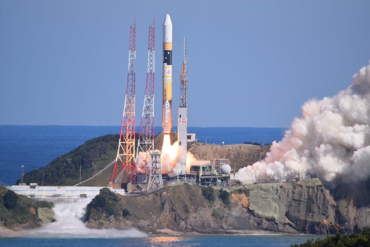
A successor to the first Quasi-Zenith Satellite System (QZSS) satellite, QZS-1R, was launched at 11:19 a.m. Japan Standard Time, Oct. 26, from the Tanegashima Space Center.
QZS-1R was carried aboard H-IIA rocket No. 44 by Mitsubishi Heavy Industries. The flight proceeded as planned, and, 28 minutes 6 seconds after launch, the payload separated from the launch vehicle.
Designed for a 15-year lifetime, QZS-1R will replace the QZS-1 (Michibiki-1). QZS-1 launched on Sept. 11, 2010, and entered its quasi-zenith orbit 10 days later. Three other quasi-zenith navigation satellites launched in 2017 to complete the constellation.
QZSS began service in November 2018 with four satellites. The Japan Aerospace Exploration Agency (JAXA) plans to have seven satellites aloft by 2023.
An H-2A rocket launches from Tanegashima Space Center carrying the QZS-1R satellite. (Photo: MHI)
Galileo Control Centre in Oberpfaffenhofen, Germany. (Photo: ESA)
News from the European Space Agency (ESA)
The 11th launch of Galileo satellites, planned for Dec. 1, marks an important program milestone. With an upgrade of the Galileo Control Segment (GCS), this will be the first launch where the satellites’ first steps into space will be overseen from the Galileo Control Centre in Oberpfaffenhofen, Germany.
Up until now, the Launch and Early Operations Phase (LEOP) of Galileo satellites has been overseen from an external mission control site — either ESA’s ESOC control centre in Darmstadt, Germany, or French space agency CNES’s site in Toulouse, France.
The demanding upgrade of the GCS to Version 3.0 was performed by an industrial consortium led by GMV in Spain. The control segment encompasses the two Galileo Control Centres in Oberpfaffenhofen in Germany and Fucino in Italy, as well as six Telemetry, Tracking and Control (TT&C) ground stations used to monitor and command the 26 Galileo satellites in orbit.
As well as increasing overall reliability and cybersecurity, the new upgrade opens the way to significant expansion of the Galileo constellation, enabling oversight of up to 38 satellites.
Over the last three years, a complete technological refresh of the GCS software and hardware was done, including porting of software modules corresponding to several million lines of code, the deployment of equipment at many Galileo sites, and the execution of a rigorous level of testing throughout all elements comprising the system.
Commencing in mid-2018, the upgrade had to contend with the worldwide COVID-19 pandemic midway through its lifetime, but the team pushed on to conclude at the end of July. Since Aug. 4, it has been used to nominally operate all the satellites in the constellation.
The project was overseen by ESA in its System Prime role managing Galileo’s design, development, qualification and deployment of future upgrades on behalf of the European Commission, Galileo’s owner.
A new video celebrates the first decade of Europe’s satellite navigation system Galileo, which celebrates its 10-year anniversary on Oct. 21.
Galileo delivers meter-level accuracy anywhere on Earth. It is also saving lives, by relaying distress calls for search and rescue. Today, 26 Galileo satellites orbit 23,222 km above the Earth. The first was launched on Oct. 21, 2011; nine more launches followed to create the constellation.
The satellites in space are supported by a globe-spanning ground segment. The system as a whole is set to grow, with the first dozen Batch 3 about to join the current satellites in orbit and Galileo Second Generation satellites in development.
UPDATE: Because of bad weather, the launch is now scheduled for Oct. 26 (Oct. 25, 18:45 p.m. PT).
The launch of the “QZS-1R”, the replacement for QZS-1 by H-IIA No. 44 scheduled for Oct. 25 is postponed as a result of weather assessment. New launch date is Oct. 26. #H2AF44
A successor to the first Quasi-Zenith Satellite System (QZSS) satellite is planned for launch from the Tanegashima Space Center on Monday, Oct. 25, from 11 a.m. to 12 p.m. Japan Standard Time (2-3 a.m. UTC).
Michibiki Unit 1 was launched on Sept. 11, 2010, and entered its quasi-zenith orbit 10 days later. QZSS began service in November 2018 with four satellites. The Japan Aerospace Exploration Agency (JAXA) plans to have seven satellites aloft by 2023.
The satellite, designated QZS-1R, will be carried aboard H-IIA rocket No. 44. The QZSS launch will be streamed live. The broadcast program will begin at 10:35 a.m. JST.
Local launch times
Houston: Sunday, October 24, 21:00 New York: Sunday, October 24, 22:00 London: Monday, October 25, 03:00 UAE: Monday, October 25, 06:00 Singapore: Monday, October 25, 10:00
To follow upcoming GNSS satellite launches, see our launch table, provided by Innovation editor Richard Langley.
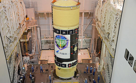
H-IIA Launch Vehicle No. 44 at the Yoshinobu Vehicle Assembly Building, JAXA Tanegashima Space Center. in preparation for launch of the successor to the Michibiki Unit 1 on Oct. 25. (Photo: MHI)
Shinichi Nakasuka, professor at the University of Tokyo Graduate School of Engineering and member of the Cabinet Office Space Policy Committee, released the following statement about the upcoming launch.
“Three years after the full operation of the four-machine Michibiki started in 2018, as the chairman of the Quasi-Zenith Satellite System Business Promotion Committee of the Cabinet Office, we strive to ensure the reliable operation and expansion of the use of this world-class system.
“I feel that high-precision positioning and two-way communication services in the event of a disaster, which cannot be achieved by GPS alone, are gradually taking root as social infrastructure. In modern society, the provision of highly accurate position and time is exactly the infrastructure that is indispensable as the ‘nerve network’ of society.
“To make that more reliable, the successor to the first machine, which pioneered this system, is about to be launched. We pray for the success of the launch and satellite operation, and hope that the Quasi-Zenith Satellite System will become more and more established in society, and that many people will be able to use this system for various purposes, including business.”
This week Sen. Patrick Leahy (D-Vt.), chair of the Senate Appropriations Committee, released that body’s version of nine different appropriations bills. The accompanying report for the bill to fund the Transportation Department (DOT) outlines the Senate’s intentions and way forward for establishing alternatives to GPS.
The report provides $15 million for the fiscal year that began on the first of October “to establish a program that leads to wide adoption of multiple technologies that provide the necessary GPS backup and complementary PNT as identified by the Department’s report.”
The department report referenced was on a demonstration project that examined GPS backup and complementary technologies from 11 different vendors. That DOT report found, based on the technologies demonstrated, a combination of signals delivered from space, terrestrial low frequency (LF) and ultra-high frequency (UHF) broadcasts, and fiber would best meet the nation’s needs.
The Senate report accompanying the funding bill outlines components of the GPS alternatives program, including:
development of safety-critical PNT requirements and standards,
user adoption models to facilitate responsible use of resilient PNT, and
procurement of services deemed appropriate by the department.
The Senate Committee report can be found here. Relevant provisions are on page 12.
Services Contracts
While not setting a deadline for issuance of a Request for Proposal, the mention of procuring services is seen by many as a strong indication that Congress expects more than just additional studies.
Services contracts, as opposed to the government building its own system, have long been advocated by numerous members of industry and by the Resilient Navigation and Timing Foundation. Contracting for services with commercial providers is a better model, they have argued, as the needed technologies are mature and commercially available. Also, issuing one or more services contracts would avoid the need for the huge funding lines and lengthy delays inherent in a government major systems acquisition.
Many have suggested that services contracts would also be a much more economical approach for the government. They say commercial interests can operate their systems more efficiently, and that they could offer additional services to other customers, potentially reducing costs to the government.
ADS-B Sets Example
Such an approach was used by the Federal Aviation Administration (FAA) for the ADS-B air traffic safety and management system. The FAA needed to monitor and use signals from ADS-B equipment aboard a wide variety of aircraft flying in U.S. airspace. Rather than building a nation-wide ground infrastructure, the FAA issued a long-term service contract for a company to collect and provide the signals. The awardee, Exelis (now L3Harris), won the contract, built the infrastructure, and now provides ADS-B information to the FAA and others on a subscription basis.
Most observers expect the portions of the Senate bill and report about the GPS alternatives program to be adopted in conference with the House and then enacted into law.
How far the Department of Transportation will be able to develop the program this fiscal year remains to be seen. The Senate provisions do require DOT to report on its progress in a year’s time. Earlier informal reports and updates to the committee are likely to inform funding and other legislation on this effort for fiscal year 2023.
Dana A. Goward is President of the Resilient Navigation and Timing Foundation
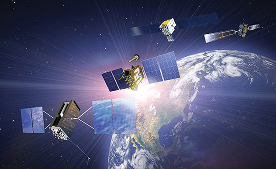
The tremendous benefits of having four complete GNSS constellations
In 2020, with the completion of China’s BeiDou-3 (aka BDS) and Europe’s Galileo, the number of available global navigation satellite system (GNSS) constellations doubled.
Analogously to the addition of GLONASS to GPS a quarter century earlier, but much more so, this sharp increase in the number of available satellites and frequencies greatly improved the precision of satellite-based positioning, the speed of first fix, and the confidence in the results — especially in GNSS-challenged places, such as under thick canopy and in deep urban canyons.
Additionally, this new ability to track three or four GNSS constellations makes the overall positioning solution more resilient to malicious RF interference (jamming and spoofing), to accidental GNSS service disruptions such as Galileo’s one-week service outage in July 2019, and to deliberate withholding of service such as might occur in times of war.
While all this may make little practical difference to a driver needing to know which highway exit to take or to a pedestrian looking for the nearest pharmacy, it is very valuable in high-end applications, such as surveying and construction. In fact, surveyors who have transitioned to using all the available constellations are ecstatic.
This month’s cover story, on the benefits of having four complete GNSS constellations, is in two parts. First, Oliver Montenbruck and Peter Steigenberger discuss “the practical relevance and implications of having four GNSS in parallel for both mass-market and high-end users.” Next, I present the comments of three surveyors and a receiver manufacturer:
Gavin Schrock, PLS, is a practicing land surveyor, the operator of a cooperative real-time GNSS network in Washington state, and a technology writer
James Richards is the senior land and utility surveyor at Benchmark Surveys in Venny Bridge, UK
Choice Sterling is the survey manager at Kiewit Corporation in Federal Way, Washington
Xiaohua Wen is the CEO and founder of Tersus GNSS, a manufacturer of GNSS surveying receivers based in Australia.
(Satellites from left) GPS: In July 1995, GPS achieved full operational capability (FOC). GLONASS: In December 1995, the (then) Soviet system achieved FOC. BeiDou: On June 23, 2020, China launched the final satellite of the BeiDou-3 constellation. Galileo: The constellation has 21 usable satellites.(Credit: Satellites from public sources; background image: NASA/Chaykovsky Igor/Shutterstock.com)
James Richards Senior Land and Utility surveyor Benchmark Surveys, Venny Bridge, UK
James Richards, Benchmark Surveys
What kinds of surveying projects do you run?
We run many different types of surveying projects. From small single-story bungalow extensions and redevelopment to development of new home sites of several hundred acres. We cover land, underground utility, and measured-building surveys of any size project, using the latest equipment in total stations, laser scanners, drones, GPS receivers, ground-penetrating radar (GPR) and electromagnetic location (EML).
How have you transitioned to using multiple constellations?
Ordnance Survey benchmarks in the UK are no longer maintained. Therefore, it has been a must to move forward with the surveying world and use multi-constellation GNSS equipment. We have stayed at the forefront of GNSS receivers, starting with a Topcon GRS1 then moving onto a Trimble R10 and a Topcon HiPer SR. Now, I feel we’ve taken another leap with the Trimble R12i, working in areas where we previously did not even consider using a GNSS receiver.
How does the availability of four complete GNSS constellations, plus two regional ones, benefit your work?
The availability of four complete GNSS constellations and two regional ones gives us more reliability as well as improved position and time accuracy in the data that we receive. It also gives us better coverage over the entire UK, including near buildings and under foliage. The Trimble R12i has 672 available channels, which makes it future-proof to new frequencies and additional space vehicles.
Choice Sterling Survey manager, Kiewit Corporation Federal Way, Washington
What kinds of surveying projects do you run?
I am the survey manager on $1–3 billion mega projects, ranging from bridges and highways to tunnels and rail, including a couple of projects for the U.S. Department of Defense.
How have you transitioned to using multiple constellations?
The use of multiple constellations became available as we adopted technologies that could capitalize on their availability. Through the latest hardware and software, we have begun leveraging GNSS to a greater magnitude than we would have just a few years back.
How does the availability of four complete GNSS constellations, plus two regional ones, benefit your work?
Not long ago, the use of GPS for construction staking was an extremely risky proposition given its unreliability, primarily in the vertical component, and lack of confidence in its horizontal accuracy. With residuals exceeding most construction tolerances, GPS was primarily utilized for earthwork or to establish geodetic pairs that could then be traversed to establish control for more precise work. With the utilization of multiple GNSS constellations, we have gained confidence in the accuracy of our results and have started leveraging GPS for construction staking where we were once not willing to take the risk.
Having the ability to leverage GPS under a canopy of trees or against structures or walls has proved invaluable when running traverses or levels, typically enabling us to use a single person rather than a two-person crew. Increased confidence in repeatability and accuracy while using GPS has been a game changer when working on projects where efficiency and cost management are of the greatest importance.
How have you transitioned to manufacturing multiple-constellation GNSS receivers?
Early in 2016, we produced a GNSS receiver evolution road map to take advantage of GPS/GLONASS modernization, the continuing development of Galileo and QZSS, and the completion of BeiDou-3. In 2019, we released our current GNSS receiver, which has 576 tracking channels and supports all five major GNSS constellations (GPS, GLONASS, Galileo, BeiDou-3 and QZSS) and triple-band broadcasts (GPS L1+L2C+L2P+L5, GLO G1+G2+G3, GAL E1+E5a+E5b, BDS B1+B2a+B2b and QZSS L1+L2C+L5). We expect to release our next generation receiver, with 832 channels, in February 2022. It will support all available constellations (GPS, GLO, GAL, BDS, QZSS, IRNSS/NavIC, SBAS) and all civil signals, including the AltBoc and AceBoc.
How does the availability of four complete GNSS constellations, plus two regional ones, benefit your end users?
The most significant advantage of modern GNSS receivers is their robust high-accuracy performance with the aiding of the new constellations and signals, especially in harsh GNSS environments, such as deep canyons and heavy foliage. It greatly extended the RTK fix capability, and now reliable GNSS RTK fix solutions can be easily achieved in areas where it was impossible to do in the past.
In the past, multipath always has been a problem for RTK GNSS receivers, as it might cause blunder errors. The improved RTK fix reliability based on robust RTK integrity monitoring takes advantage of the redundancy of observations to identify and isolate deteriorated observations and confirm the fixed result. Additionally, RTK achieves RTK fix solutions faster and maintains the RTK fix solutions easier with better accuracy than before.
Compared to the dual-band (L1+L2) of GPS plus GLONASS, the triple-band (and multi-band) can allow long-range RTK capability, which can provide reliable RTK solutions with a remote GNSS base station far from the 20–30 km base and rover separation of the past. It also will provide more confidence in RTK positioning during the coming ionospheric disturbance peak in 2023.
Knowing your position is only part of navigation. (Photo: Oliver Montenbruck)
By Oliver Montenbruck and Peter Steigenberger
A year ago, the U.S. Global Positioning System celebrated its silver jubilee upon completing 25 years in operation. Also, it was more than 20 years ago that President Clinton agreed to switch off Selective Availability, thus offering seamless positioning to the civil community. The 10-bit GPS week count experienced its second rollover, and people worldwide got addicted to a ubiquitous positioning capability in those decades. Be it for finding the nearest restaurant or to track a Sunday afternoon bike ride, positioning-related services building on GPS have become an integral part of our daily life. In fact, GPS has almost become a synonym for navigation itself.
One cannot underestimate the contribution that GPS has made to society. It is for sure most deserved that the fathers of GPS were ultimately awarded the highly prestigious Queen Elizabeth Prize for Engineering in the year of the above jubilee. As always, success creates followers, and GPS is no longer the sole player. Next to the Russian GLONASS, two new actors — namely the European Galileo and the Chinese BeiDou-3 GNSS — have mounted the stage. So, users are now offered a choice of four independent GNSS.
However, do we really need so many systems? Isn’t one enough and all others just a waste of taxpayers’ money? The answer to the last question is certainly a clear “no.” Our society already depends on, to a large extent, the availability of positioning, navigation and timing (PNT) services in much the same way we depend on electricity and telecommunication. While mass-market applications such as the ones mentioned above may appear dispensable, there are “hidden” but much more critical applications of GPS, such as synchronizing power lines, stock trading or the base stations of cellular networks.
Clearly, there is a well-justified rationale for nations or groups of nations to build their independent, space-based navigation systems. Well beyond possible military considerations, this is a basic strategic interest for protection of the local economy and of critical infrastructure. Along with these interests, various regulatory conditions may apply that only endorse the use of selected systems for specific applications, such as emergency call systems. Overall, however, all GNSS in place today can be received and utilized by all interested users around the globe.
So, let’s have a closer look at the practical relevance and implications of having four GNSS in parallel for both mass-market and high-end users. The most obvious consequence is certainly an almost four-fold increase in the number of satellites. As of today, the four GNSS comprise more than 100 satellites, out of which 30 to 40 are simultaneously visible and available for positioning at common sites with open-sky conditions. As a rule of thumb, this provides a factor-of-two reduction of statistical errors compared to using only GPS.
Most importantly, however, the prospects for tracking enough satellites for positioning in obstructed sites is greatly improved. The larger number of visible satellites is particularly appealing for GNSS radio scientists who aim to derive temperature and humidity profiles from subtle variations in GNSS signals passing through diverse atmospheric regions. Multiple GNSS allow for better resolution and ultimately benefit weather forecasts.
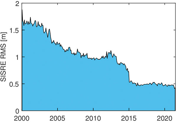
In terms of positioning, the simple statistical benefits of tracking a large number of satellites are probably outweighed by technological advances in GNSS satellites and ground systems, as well as substantial progress in receiver technology. For GPS, the signal-in-space range error (SISRE) that describes the contribution of broadcast orbit and clock errors to the position accuracy has decreased by more than a factor of three (Figure 1).
FIGURE 1. Evolution of the GPS signal-in-space range error over time. (Image: O. Montenbruck and P. Steigenberger)
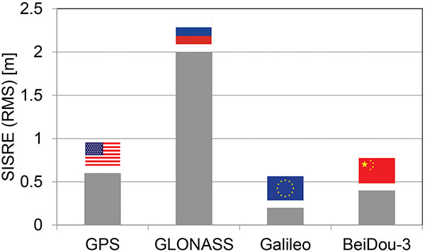
For GPS, but also Galileo and BeiDou-3, the use of highly stable atomic frequency standards has contributed to a notable reduction of the error budget of broadcast ephemerides. The same applies for fast upload capabilities, as in Galileo, or the use of intersatellite links in BeiDou-3. With SISRE values of 0.1–0.2 m and 0.3–0.4 m, these constellations enable even more accurate positioning today than GPS and GLONASS (Figure 2).
Figure 2. Signal-in-space ranging errors of the four GNSS. (Image: O. Montenbruck and P. Steigenberger)
However, improvements from new signals and multiple constellations are not only limited to single-point positioning, but likewise apply for precise point positioning (PPP) users. Stable clocks onboard the satellites reduce the update rate and bandwidth for real-time correction users. Digital signal generation units in modernized satellites ensure clean chip shapes in the transmitted ranging signals and reduce the scatter of satellite/receiver biases. Last but not least, the increased number of tracked satellites contributes notably to reducing the convergence time required for successful ambiguity fixing.
Concurrent progress in receiver technology was certainly a prerequisite for being able to track the multitude of new signals that became available with the new and modernized constellations. Compared to early GPS receivers with a few tens of channels, modern geodetic receivers may (or even must) support in the order of 1,000 channels. For mass-market users, the recent introduction of dual-frequency chipsets for mobile phones and car navigation systems marks the most important step forward. These chipsets support joint tracking of signals from GPS, Galileo and BeiDou-3 at the common L1/E1/B1 and L5/E5a/B2a center frequencies. The signals’ chipping rates, modulations and signal power are designed to offer reduced measurement noise, better multipath protection, and improved weak-signal tracking. At the same time, the use of two signal frequencies allows for rigorous elimination of ionospheric path delays, thus removing the biggest contributor to the error budget of low-cost positioning devices.
All in all, the availability of four GNSS means better performance, robustness, diversity and flexibility for navigation users. We should not forget, however, that all GNSS use basically the same core technology and share the same vulnerabilities. We must still give due attention to the challenge of toughening, augmenting and complementing GNSS to meet society’s needs for robust and assured PNT.
Oliver Montenbruck is the head of the GNSS Technology and Navigation Group and Peter Steigenberger is a senior scientist at the German Space Operations Center, German Aerospace Center (DLR).
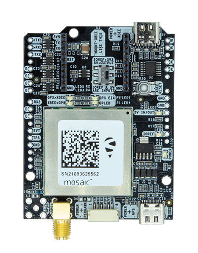
The mosaic-X5 and mosaic-H modules are being integrated into ArduSimple’s new evaluation kits, making resilient cm-level positioning easily accessible for testing and prototyping
With these new kits, ArduSimple brings to market triple-band real-time kinematic (RTK) GPS/GNSS as a plug-and-play solution for the most popular development platforms such as Arduino, STM Nucleo, Raspberry Pi, Ardupilot and Nvidia Jetson.
ArduSimple enables developers of robotics, UAVs and autonomous systems to easily try out mosaic, a unique module offering the latest high-performance GNSS positioning technology.
“The mosaic module complements the ArduSimple RTK product portfolio with a higher-end solution for the most demanding applications,” said Marc Castillo, senior consultant at ArduSimple. “Triple-band GNSS brings extra reliability to the RTK solution and removes the headache of transitioning from L2 to L5 band. This, combined with its feature-rich software, will allow our customers to accelerate even more their time-to-market.”
In addition to triple-band GNSS, mosaic module offers unmatched resilience to radio interference. This is especially important in robotic devices where electronic components, such as cameras and servos, are located close to the GPS/GNSS receiver, often interfering with GPS signals, which are weak, and causing positioning degradation. High-accuracy positioning is delivered at a uniquely high update-rate by mosaic-X5 in single antenna mode. Meanwhile, the board which mounts mosaic-H offers all-in functionality with dual-antenna mode for accurate GNSS heading.
“By partnering with ArduSimple we are bringing mosaic to emerging markets where its outstanding performance makes a difference. Mosaic makes accurate positioning so much easier to integrate and use, while giving a competitive edge to new products,” said Gustavo Lopez, market access manager at Septentrio. “ArduSimple is a great partner because they are known in the industry for offering user-friendly and affordable evaluation kits for RTK positioning, complemented by software tools, making integration and rapid prototyping easy.”
The SimpleRTK3B board, which allows evaluation of the mosaic GNSS module, is now available for purchase via the ArduSimple web shop. For more information about mosaic or other Septentrio products visit septentrio.com or contact Septentrio.
The free resources are intended to advance the design of PNT systems and increase resilience of critical infrastructure to PNT disruptions.
The GPS Whitelist Development Guide presents a software assurance approach to addressing potential vulnerabilities and increasing reliability of GPS receivers. The guide addresses data-related requirements in the Resilient PNT Conformance Framework, which provides guidance for defining expected behaviors in resilient PNT equipment.
“We hope this guide and related resources will help industry advance towards a cybersecurity-based approach to PNT resilience,” said S&T Technical Manager Ernest Wong.
Originally released in March 2021 as open source on GitHub, the PNT Integrity Library provides users with a method to verify the integrity of the received GPS data. The update includes:
A compliance check on Interface Control Document (ICD) IS-GPS-200, which is a formal means of establishing, defining and controlling communication between the GPS space and other user systems; and
A Do-It-Yourself (DIY) Toolkit, which describes how a perspective end-user of the PNT Integrity Library can assemble a demonstrational toolkit with commercial-off-the-shelf (COTS) hardware.
“Since GPS signals can be jammed or spoofed, critical infrastructure systems should not be designed with the assumption that GPS data will always be available or will always be accurate,” said S&T Project Manager Brannan Villee. “Application of these tools will provide increased security against GPS disruptions. However, DHS also recommends a holistic defense strategy that considers the integrity of the PNT data from its reception through its use in the supported system.”
A notice of award was posted Oct. 11 by the European Union for seven contracts to six different companies for demonstration of non-GNSS positioning, navigation, or timing solutions.
The awardees are OPNT BV from the Netherlands; Seven Solutions SL from Spain; SPCTime of France; GMV Aerospace of Spain; Satelles Inc. of the United states; and Locata Corporation of Australia.
Locata received two separate contract awards: one to demonstrate delivery of time, and the other for positioning.
According to the EU project officer, Ignacio Alcantrailla-Medina, some of the awardees will demonstrate delivery of time, some positioning, and some both. Locata received separate awards because the company provided separate responses for timing and positioning.
Eleven different companies responded to the tender, according to the announcement. No information was provided on the unsuccessful bidders.
The EU tender for this project was announced in October 2020. The stated goal of the project is to better understand available non-GNSS PNT technologies. The intent is to identify potential backups for GNSS during an outage. All offered technologies were required to be able to operate independently from and have “no common points of failure with” GNSS.
Alcantrailla-Medina says the demonstration project is expected to last seven and a half months. As part of this, a public event will be held at the EU’s Joint Research Center in Ispra, Italy, in March or April, 2022. This will be followed by a consolidated report on the project in May or June.
This consolidated report will be used in the next edition of the European Radionavigation Plan due out next fall, according to Alcantrailla-Medina.
Companies that did not respond to the EU’s tender or were not selected for a contract can still have information about their products and services included in the consolidated report, says Alcantrailla-Medina. Now that all contracts for the demonstrations have been awarded, he is open to receiving the information and can be contacted at:
Ignacio.ALCANTARILLA-MEDINA
European Commission
DG Defence Industry and Space
Unit C2 – Satellite Navigation
Avenue d’Auderghem 45, (BREY 7/297)
B-1049 Brussels/Belgium