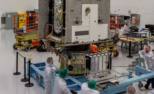
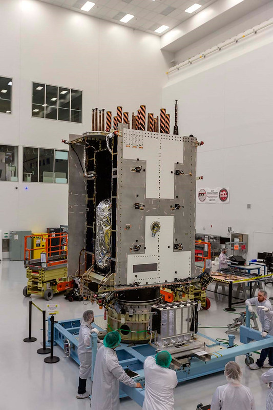
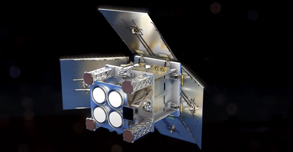
GPS III Space Vehicle (SV) 05 was transported from the Lockheed Martin facility in Waterton, Colorado, to the Space Coast Regional Airport in Titusville, Florida, by a C-17 Globemaster III crew from Joint Base Lewis-McChord, Washington. Lockheed Martin is the contractor for construction of the GPS III satellites.
Now that the satellite has arrived at the Astrotech Space Operations facility, the latest addition to the GPS constellation modernization effort will begin final testing and checkout before the launch. While at Astrotech, it will undergo final post-ship functional testing, be fueled with onboard propellant, and then be encapsulated for launch.
Once these tasks are accomplished, SV05 will be horizontally integrated with the first-ever SpaceX Falcon 9 launch vehicle to be reflown for a National Security Space Launch (NSSL) mission.
“SV05 is the third GPS III satellite shipped to the Cape in the last 14 months and marks a key step to our larger goal of GPS constellation modernization,” said Col. Edward Byrne, SMC’s Space Production Corps Medium Earth Orbit Space Systems Division chief. “As the fourth GPS III launch campaign with SpaceX, this NSSL mission is historic both for the first reflight of a Falcon 9 rocket and for being the 24th military-code (M-code) satellite introduced to our constellation, the last needed to bring M-code to full operational capability.”
Slated to launch in June, GPS III SV05 will join the operational constellation of 31 GPS satellites, delivering enhanced performance and accuracy through a variety of improvements.
Improvements include increased signal protection, L1C signal interoperability, and the newest civilian signal, L5. As a crucial technological foundation for internet, financial, transportation and agricultural operations, GPS delivers the gold standard in positioning, navigation and timing services supporting U.S. and allied operations worldwide.
The U.S. Space Force’s Space and Missile Systems Center, located at the Los Angeles Air Force Base in El Segundo, California, is the center of excellence for acquiring and developing military space systems. SMC’s portfolio includes space launch, global positioning systems, military satellite communications, a meteorological satellite control network, range systems, space-based infrared systems, and space situational awareness capabilities.
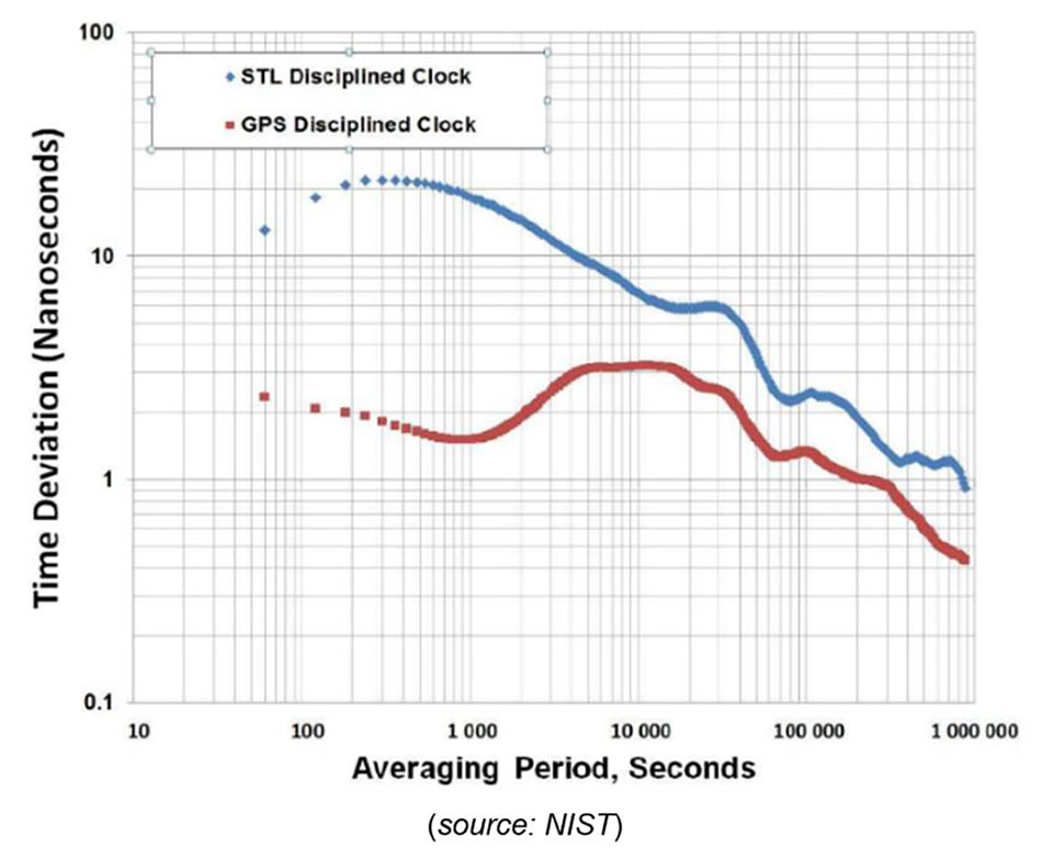
Study by U.S. government agency responsible for maintaining national time scale shows that Satelles provides a signal that is independent of GNSS and delivers exceptional timing stability
Following a detailed performance study in 2020, the U.S. National Institute of Standards and Technology (NIST) determined that Satellite Time and Location (STL) is a reliable source of timing highly consistent with Coordinated Universal Time (UTC). The secure STL services are provided by Satelles Inc.
STL is based on a signal independent from GPS and other GNSS. The STL service was able to deliver this consistent performance in a deep indoor environment where GNSS signals did not reach.
The results of the study were shared by Elizabeth Donley, chief of the Time and Frequency Division at NIST, in a keynote speech at the Workshop on Synchronization and Timing Systems (WSTS) conference on April 1.
Donley articulated the details of the NIST study, in which a GPS-disciplined clock and a Satelles EVK-2 evaluation unit with a quartz oscillator were compared to UTC for 50 days. In this evaluation, the GPS device received its signal from an outdoor antenna, whereas the Satelles device was connected to an indoor antenna in a deep indoor environment where GNSS signals were not able to reach.
Time deviation calculations estimated the stability of the two signals with respect to the UTC time scale. Based on one day of averaging, the GPS instability was less than two nanoseconds, and the STL instability was only slightly higher at under three nanoseconds (see chart). These measurements demonstrated that STL delivers stability comparable to GNSS and does so in an indoor location where GPS signals usually cannot penetrate.
Image: NIST
STL delivers a positioning, navigation and timing (PNT) service from satellites in low Earth orbit (LEO) to back up or augment GPS and other GNSS. The evaluation by NIST confirms that users of PNT-reliant applications can obtain accurate and reliable timing without using GNSS.
“We are thrilled that NIST has performed these independent tests that confirm what we have long known, which is that STL delivers an independent timing source that is reliable and highly consistent with UTC,” said Gregory Gutt, president and CTO of Satelles. “This report complements and reinforces the findings of the U.S. Department of Transportation, which identified STL as a top-ranked PNT system in its technology demonstration report released earlier this year, and showed STL to be the only solution that demonstrated a wide-area timing capability that works indoors and out.”
Image: 3DSculptor/iStock/Getty Images Plus/Getty Plus
The European Space Agency (ESA) has commissioned Euroconsult to conduct a study on the future of the European space transportation sector.
Euroconsult, a global consulting firm specializing in space markets, has partnered with the European Space Policy Institute (ESPI) to investigate European institutional mission scenarios for the period beyond 2030 following the ITT on New European Space Transportation Solutions (NESTS).
Euroconsult and ESPI will deliver an independent analysis focusing on the demand drivers of the future space transportation solutions in the period 2030–50 along already awarded contracts to ArianeGroup, Avio and Rocket Factory Augsburg (a subsidiary of OHB SE).
Space transportation technologies are intrinsically complex, some needing long development cycles of up to a decade, explained ESA. In March, ESA signed within NESTS study contracts of €500,000 with ArianeGroup, Avio and Rocket Factory Augsburg (a subsidiary of OHB SE).
These companies are tasked with carrying out research over the next few months. This will enable them to identify and recommend preliminary elements for future space transportation solutions to be used in the period 2030–50.
“ESA, through its New European Space Transportation Solutions initiative, lays the foundations that enable us to prepare the future beyond Ariane 6 and Vega-C,” said Daniel Neuenschwander, ESA director of Space Transportation. “These system concept studies will include services that prioritize the future needs of Europe’s space programs but also allow us to address global market needs.”
“Space transportation capabilities are evolving due to changes in launch demand and customers’ requirements and to the availability of innovative and cost-effective solutions serving these,” stated Euroconsult CEO Pacôme Revillon. “Euroconsult and ESPI expertise combined will guarantee the independence and neutrality of the results. All partners are fully committed to delivering a study that lays the groundwork for the future of the European space transportation sector,” he added.
The studies will be completed before June and will feed the preparation of proposals to be submitted for decision at the next Council Meeting at Ministerial level in 2022.
Project will boost the positioning performance and real-time operability of the Galileo system.
The European Space Agency (ESA) has selected Thales Alenia Space to support the implementation and experimentation of the navigation algorithms that will be used in the Galileo Second Generation program. Under the contract, Thales will develop the Advanced Orbit Determination and Time Synchronisation (ODTS) Algorithms Test Platform (A-OATP).
Thales Alenia Space, a joint venture between Thales (67%) and Leonardo (33%), is the prime contractor for Galileo First Generation’s Ground Mission Segment,.
ESA granted the contract on behalf of the European Commission in the Horizon 2020 Satellite Navigation Program (HSNAV).
In a previous contract, Thales Alenia Space was chosen to provide six satellites and initiate the B2 phase of development and implementation of its ground segment for the Galileo Second Generation constellation.
Using its long-standing legacy regarding navigation algorithms in addition to an innovative approach, Thales Alenia Space will develop and test a new Advanced ODTS solution. The new orbitography algorithms will allow a significant improvement in positioning performance and real-time operability of the Galileo system. It will exploit the accuracy of the GNSS orbit and clock estimation, with a solution optimized for the real-time generation of Galileo navigation messages, and take full advantage of the evolution of satellites and ground stations considered in the Galileo Second Generation.
With this new contract, Thales Alenia Space applies on a deep experience concerning orbitography algorithms as well as knowledge of the Galileo system to strengthen its position as a major actor for the development of the new generation of this satellite system, the company stated in a press release.
Projects will advance technology used for secure GNSS, quantum timekeeping and communications
ColdQuanta, which specializes in cold atom quantum technology, has been awarded two development contracts from U.S. government agencies worth $2.55 million. Both projects are based on the company’s Quantum Core technology, which uses atoms cooled to a temperature of nearly absolute zero and lasers to manipulate and control the atoms with extreme precision.
Prototype Atomic Clock
The Office of the Under Secretary of Defense for Research & Engineering (OUSD R&E) awarded ColdQuanta $1.8 million for the development of a prototype atomic clock that could enable reliable, highly accurate position, navigation and timing (PNT) capabilities necessary for the functioning of critical infrastructure around the world. Atomic clocks are used for GPS/GNSS systems as well as for time-distribution services that are the basis of financial networks, computer, TV and radio services and other applications.
Alternative PNT. However, services such as satellite-based GPS can be spoofed, lack encryption or other security features, and often can’t deliver the signal strength required. Because of this, the development and deployment of a PNT system that doesn’t depend on GPS is a critical need across governments and industry, according to ColdQuanta. The company said this is especially true for mobile systems such as aircraft and spacecraft that need to know their position with great precision even when GPS is unavailable.
Under this project, ColdQuanta will deliver a state-of-the-art atomic clock with “instant on” capability if a GPS signal is lost, with a timing accuracy comparable to the best commercial clocks. It will also be ruggedized, portable and compact to enable its use in aircraft, and will minimize the power draw in between periods of demand.
“High-performance atomic clocks are the backbone of the internet, electrical power grids, financial networks, and autonomous navigation. Combining this with ColdQuanta’s development of related inertial navigation devices — such as gyroscopes, accelerometers and gravimeters — will lead to the first Quantum Positioning Systems,” said Dan Caruso, executive chairman and CEO of ColdQuanta. “We’re excited to work closely with the Department of Defense to meet their urgent needs, while also advancing the capabilities needed for future, unassailable global positioning technology.”
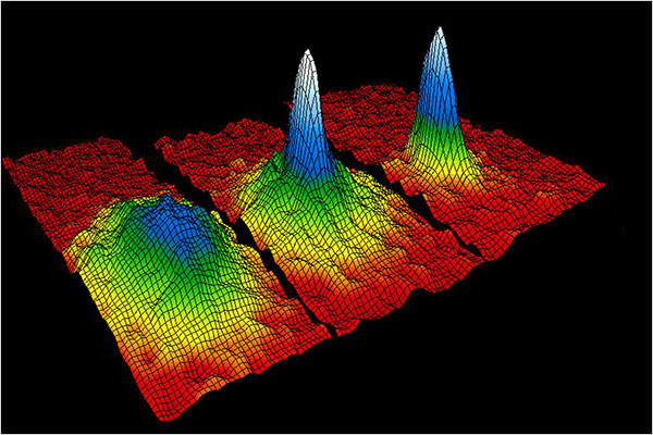
This velocity-distribution data for a gas of rubidium atoms confirmed the discovery of the Bose–Einstein condensate in 1995. In these three snapshots in time, atoms—cooled to near absolute zero—condensed from less dense areas on the left (red, yellow, and green) to very dense areas at the center and the right (blue and white). (Image: NIST/JILA/CU-Boulder)
Miniaturized Ion Trap System
Also, the Air Force Research Laboratory (AFRL) awarded ColdQuanta $750K for the development of a high-performance miniature ion trap system. Compact ion trap systems are applicable to a spectrum of quantum applications including quantum networks, computing, metrology, and timekeeping.
ColdQuanta previously developed a prototype miniaturized ion trapping system with performance that is competitive with traditional, large-footprint vacuum systems. The system maximizes performance and robustness while minimizing size, weight, and power consumption (SWaP). The new AFRL award will build on the success of this prototype to increase performance, reduce cost, and create a robust architecture for deployable quantum platforms.
Bose-Einstein Condensate
The story of ColdQuanta began in 1924 with the discovery of the Bose-Einstein condensate (BEC) — also known as the fifth form of matter — by Satyendra Bose and Albert Einstein. Seventy years later, BEC was first synthesized at the University of Colorado at Boulder in collaboration with the National Institute of Standards and Technology (NIST), for which Eric Cornell and Carl Wieman won a Nobel Prize in 2001. Their colleague, Dana Anderson, co-founded ColdQuanta, which is using the fifth form of matter as the foundation for its cold atom quantum technology.
When atoms are cooled to a few millionths of a degree above absolute zero, they take on quantum properties. Lasers are used to arrange the atoms, hold them in place, run computations on them, and read out the results. Quantum calculations, communications and sensing are the result.
ColdQuanta is collaborating with global customers including major commercial and defense companies; the U.S. Department of Defense; national laboratories operated by the Department of Energy, NASA, and NIST; major universities; and quantum-focused technology companies to advance products and services development with Cold Atom Quantum Technology. ColdQuanta is based in Boulder, with offices in Madison, Wisconsin, and Oxford, United Kingdom.
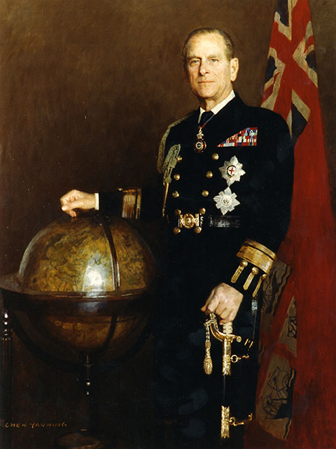
The official portrait of HRH The Duke of Edinburgh as Master of Trinity House. (Image: Trinity House)
Prince Philip, technology advocate, championed both GPS and alternative navigation methods during his lifetime.
Prince Philip — the Duke of Edinburgh and husband of Queen Elizabeth II of the United Kingdom — died on April 9 at Windsor Castle in England. He was 99. His funeral will take place April 17.
As the Master of Trinity House, Prince Philip was the U.K.’s authority for lighthouses in England, Wales, the Channel Islands and Gibraltar. Trinity House is also responsible for the provision and maintenance of other navigational aids, such as light vessels, buoys and maritime radio/satellite communication systems.
In its extensive coverage of his death, the BBC aired a radio program in its World Service that mentioned the prince’s knowledge and concern about GPS. “As Master of Trinity House, he was infuriated that people didn’t understand what would happen if GPS were shut down,” said the narrator.
Real Admiral Sir Jeremy de Halpert was Prince Philip’s deputy master at Trinity House. “ Prince Philip from the very beginning understood that it was a single point of failure,” de Halpert told the BBC. “GPS can be jammed very easily… He encouraged us to move ahead and make sure the country has a failsafe backup, which we have done, and it is now operational,” he said.
Below is the section of the documentary where the prince’s support for GPS and a GPS backup is discussed.
GPS World thanks Innovation editor Richard Langley for sharing the material.
The ION GNSS+ 2021 technical program is online, and registration for the event is now open. ION GNSS+ 2021 takes place Sept. 20-24 at the St. Louis Union Station Hotel in St. Louis, Missouri.
ION GNSS+ 2021: GNSS + Other Sensors in Today’s Marketplace, is the 34th International Technical Meeting of the Satellite Division of the Institute of Navigation, and the world’s largest technical meeting and showcase of GNSS and GNSS-related technology, products and services.
“It’s exciting to be meeting in-person in St. Louis,” said Lisa Beaty, ION executive director. “We are expecting a pent-up demand as the community is eager to convene and get caught up. The ION GNSS+ 2021 technical and commercial exhibit is the best opportunity of the year to see what’s been happening in PNT [positioning, navigation and timing].”
ION GNSS+ 2021 features more than 300 technical presentations under two technical tracks: Commercial and Policy, and Research. The opening Plenary Session will feature two keynote addresses: “Towards a Smart Digital Reality: Building a Sustainable Future,” presented by Burkhard Boeckem, and “Artemis: Return to the Moon” presented by Steven Clarke, NASA.
For those unable to attend in person, ION GNSS+ 2021 will include a virtual option. Registration offers access to all on-demand conference content, live streams of select sessions, proceedings, as well as recordings of the sessions that were live streamed during the conference. ION GNSS+ Virtual Registration includes virtual contact with ION GNSS+ exhibitors and CGSIC’s technical program.
To view the ION GNSS+ 2021 technical program and to register, go to ion.org/gnss.
The United Kingdom’s National Timing Centre will conduct a two-phase series of funded studies and demonstrations focusing on “innovation in the dissemination and application of resilient time, frequency and synchronisation.”
The first round now being advertised is for feasibility studies of projects costing between £50,000 and £250,000. Total funding for the round is £2M. A briefing for interested parties will be held on April 20.
The second round and remaining funding will be devoted to technology demonstrations.
The UK’s National Timing Centre was established in response to several national studies and concerns about the vulnerability of space-based timing services.
Severe solar storms, called coronal mass ejections, were listed on the UK National Risk Register in 2012. While rare, these events can damage assets in space and on the ground.
Next month marks the 100th anniversary of the New York Railroad Storm. It was so powerful, telegraph offices were set on fire in the U.S. and Europe, fuses were blown, and equipment damaged. Even underwater telegraph cable traffic was affected.
Experts say if such a storm were to strike the Earth today, it would likely damage GPS and other GNSS satellites. At a minimum, it would charge the atmosphere and prevent signals from getting through for days.
Projects that will be considered for the UK competition must be technologies and application areas providing trust, assurance, security and resilience for time distribution.
While supported by Innovate UK, the National Physical Laboratory (NPL), which operates the virtual National Timing Centre, appears to be the primary agent for execution. NPL will offer applicants who are selected to participate in the feasibility study phase free technical consultation up to 12 hours, and free access to highly precise and accurate time signals from four NPL locations in the southeast of England.
Since its inception, the National Timing Centre seems to have concentrated on establishing distributed suites of atomic clocks, probably linked by fiber, as a first step to improving the nation’s timing resilience.
Industry observers have opined that future efforts are likely to focus on wireless distribution.
“Wireless requires less infrastructure and has no user limit,” said one. “It only makes sense they would go there once they feel they have a solid clock foundation.”
The competition is open to UK entities. Applications will be accepted April 19-June 9, with accepted participants notified on July 30.
Europe’s Lunar Pathfinder mission to the Moon will carry an advanced satellite navigation receiver to perform the first satellite navigation positioning fix in lunar orbit. The experimental payload marks a preliminary step in an ambitious European Space Agency (ESA) plan to expand reliable satnav coverage — as well as communication links — to explorers around and ultimately on the Moon during this decade.
Due to launch by the end of 2023 into lunar orbit, the public-private Lunar Pathfinder comsat will offer commercial data-relay services to lunar missions, while also stretching the operational limits of satnav signals.
Navigation satellites like Europe’s Galileo constellation are intended to deliver positioning, navigation and timing services to our planet, so most of the energy of their navigation antennas radiates directly towards the Earth disc, blocking its use for users further away in space.
“But this is not the whole story,” explains Javier Ventura-Traveset, leading ESA’s Galileo Navigation Science Office and coordinating ESA lunar navigation activities. “Navigation signal patterns also radiate sideways, like light from a flashlight, and past testing shows these antenna side lobes can be employed for positioning, provided adequate receivers are implemented.”
Just like people or cars on the ground, satellites in low-Earth orbit rely heavily on satnav signals to determine their orbital position, and since ESA proved higher orbit positioning was possible, a growing number of satellites in geostationary orbit today employ satnav receivers.
But geostationary orbit is 35,786 km up, while the Moon is more than ten times further away, at an average distance of 384 000 km. In 2019 however, NASA’s Magnetospheric Multiscale Mission acquired GPS signals to perform a fix and determine its orbit from 187,166 km away, close to halfway the Earth-Moon distance.
“This successful experimental evidence provides us high confidence since the receiver we will embark on Lunar Pathfinder will have a significantly improved sensitivity, employ both Galileo and GPS signals and will also feature a high-gain satnav antenna,” Javier added.
The main challenge will be overcoming the limited geometry of satnav signals all coming from the same part of the sky, along with the low signal power.
The high-sensitivity receiver’s main antenna was developed through ESA’s General Support Technology Programme, with the receiver’s main unit developed through ESA’s Navigation Innovation and Support Programme, NAVISP.
The receiver project is led by ESA navigation engineer Pietro Giordano. “The high sensitivity receiver will be able to detect very faint signals, millions of times weaker than the ones received on Earth. The use of advanced on-board orbital filters will allow for unprecedented orbit determination accuracy on an autonomous basis,” Giordano said.
Lunar Pathfinder’s receiver is projected to achieve positioning accuracy of around 100 meters — more accurate than traditional ground tracking.
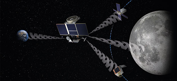
Once in a stable elliptical orbit over the lunar south pole, Lunar Pathfinder will relay signals from other Moon missions. (Image: ESA)
The availability of satnav will allow the performance of ‘Precise Orbit Determination’ for lunar satellites, said Werner Enderle, head of ESA’s Navigation Support Office. “Traditional orbit determination for lunar orbiting satellites is performed by radio ranging, using deep space ground stations,” Enderle said. “This Lunar Pathfinder demonstration will be a major milestone in lunar navigation, changing the entire approach. It will not only increase spacecraft autonomy and sharpen the accuracy of results, it will also help to reduce operational costs.”
While lunar orbits are often unstable, with low-orbiting satellites drawn off course by the lumpy mass concentrations or mascons making up the Moon, Lunar Pathfinder is planned to adopt a highly stable “frozen” elliptical orbit, focused on the lunar south pole – a leading target for future expeditions. Earth — and its satnav constellations — should remain in view of Lunar Pathfinder for the majority of testing. The main challenge will be overcoming the limited geometry of satnav signals all coming from the same part of the sky, along with the low signal power.
Lunar Pathfinder’s demonstration that terrestrial satnav signals can be employed to navigate in lunar orbits will be an important early step in ESA’s Moonlight initiative. Supported through three ESA Directorates, Moonlight will establish a lunar communication and navigation service.
“Over this coming decade, ESA aims to contribute to building up a common communications and navigation infrastructure for all lunar missions based on dedicated lunar satellites,” explained Bernhard Hufenbach, managing commercialisation and innovation initiatives for space exploration at ESA. “Moonlight will allow to support missions that cannot use Earth satnav signals, such as landers on the far side and is planning to cover the current gap towards the needs expressed by the Global Exploration community, targeting positioning accuracy below 50 meters.”
As well as facilitating lunar exploration, these satnav signals might one day become a tool for science in their own right, used, for example, to perform reflectometry across the lunar surface; sounding the scant dusty exosphere that surrounds the Moon or by providing a common time reference signal across the Moon, to be used for fundamental physics or astronomy experiments.
Javier noted that Lunar Pathfinder’s satnav experiment also will have larger consequences. “This will become the first-ever demonstration of GPS and Galileo reception in lunar orbit, opening the door to a complete way to navigate spacecraft in deep space, enabling human exploration of the Moon,” he said.
The European GNSS Agency (GSA), with the European Commission, has published an information note on the Galileo High Accuracy Service (HAS). The 16-page document provides an overview of the main characteristics of the service, information on features such as service levels, target performance, an implementation roadmap, and an overview of the target markets for the service.
Target markets for Galileo HAS include geomatics, precision agriculture, consumer solutions and the space sector.
The market for high-accuracy positioning is dynamic, driven by various factors, including
emerging applications such as autonomous vehicles and drones;
technological advances such as dual-frequency chipsets for the mass-market; and
the market situation, with cheap or free-of-charge augmentation services available in some countries.
These factors are resulting in the democratization of high accuracy, which is becoming a more widespread commodity, rather than the exclusive domain of professional applications.
With the Galileo HAS, Galileo will pioneer a worldwide, free high-accuracy positioning service aimed at applications that require higher performance than that offered by the Galileo Open Service.
Benefitting several markets
Target markets for the HAS include geomatics, agriculture or consumer solutions. Transport is also a major potential target market, with possible applications in aviation, road, rail and maritime and inland waterways.
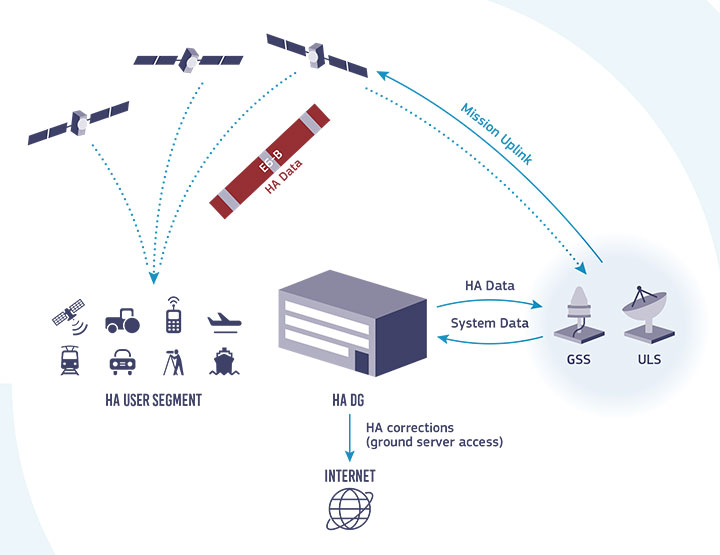
In these markets, the HAS will provide high-accuracy precise point positioning corrections for Galileo and GPS free of charge, in the Galileo E6-B data component and by terrestrial means, to achieve real-time improved user positioning performances, with a positioning error of less than two decimetres in nominal conditions.
“With its High Accuracy Service, Galileo will be the first satellite constellation able to provide a high-accuracy precise point positioning service globally, directly through the Signal in Space,” said GSA Executive Director Rodrigo da Costa. “This will be another key differentiator of the Galileo system, giving it a competitive advantage over other systems and allowing it to foster innovation in both consolidated and emerging markets.”
Galileo HAS high-level architecture. (Image: GSA)
HAS Initial Service
HAS Phase 1 will cover the provision of an initial Galileo HAS resulting from the implementation of a high-accuracy data-generation system that processes Galileo data only.
Phase 2 will see full provision of the Galileo HAS, meeting its target performance of 20-cm worldwide positioning accuracy after 2024.
Through the HAS, Galileo will offer a unique service with the transmission of corrections directly via Galileo satellites, allowing free high-accuracy positioning globally, for everyone.
A new Galileo Information Center for Mexico, Central America and the Caribbean has opened in Mexico City, with training facilities in Querétaro, Mexico. The 177-million population is a largely untapped market for space, according to Telespazio Ibérica.
Telespazio Ibérica will run the center as leader of a consortium composed of European and local industrial and institutional partners such as everis, Enaire, Geotecnologías, and universities including the Universidad Politécnica de Madrid and the Universidad Nacional Autónoma de México.
The center is co-financed by the Directorate-General for Defence Industry and Space (DG DEFIS) of the European Commission for 36 months. Its goal is to enlarge the ecosystem of Galileo Information Centers as it joins two existing centers in Chile and Brazil, active since November 2019. The centers contribute to the European Commission’s outreach to promote the EU Space Programme and foster its market uptake in Latin America.
The new center will help improve visibility of European satellite navigation and promote cooperation on Galileo and EGNOS between the EU space ecosystem and regional stakeholders. This includes building valuable insights on local GNSS markets, monitoring local and regional satellite navigation initiatives, and seeking to understand regional needs and the market potential for European GNSS. The center will provide communication, promotion and training activities.
“Telespazio Ibérica already plays a key role in the Galileo Service Center in Madrid,” said Miguel Bermudo, CEO of Telespazio Ibérica. In Madrid, the company operates on behalf of Spaceopal, a joint venture between Telespazio and the German Space Agency DLR, under the GSA contract for the Galileo Service Operator.
“We have chosen to co-finance this project with DG DEFIS to promote Galileo in Mexico, Central America and the Caribbean,” Bermudo said, “considering its presence in this important region to be of a great strategic value both in promoting the use and applications offered by Galileo and the opportunity it represents for Telespazio Group.”
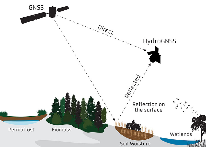
The small satellite will measure climate variables using GNSS Reflectometry
The European Space Agency (ESA) has selected HydroGNSS from Surrey Satellite Technology Ltd. (SSTL) for its second Scout Earth Observation small satellite mission. HydroGNSS is a 40-kg satellite that will be built and operated by SSTL.
ESA selected the first ESA Scout satellite, ESP-MACCS, in December 2020. ESP-MACCS focuses on understanding and quantifying processes in the upper atmosphere over the tropics — processes that play an important role in the overall evolution of the atmosphere.
HydroGNSS will take measurements of key hydrological climate variables, including soil moisture, freeze thaw state over permafrost, inundation and wetlands, and aboveground biomass, using GNSS reflectometry. It will complement missions such as ESA’s SMOS and Biomass, Copernicus Sentinel-1 and NASA’s SMAP.
Both small satellites are expected to be the first in a series of ESA Scout missions demonstrating how small satellites on a budget of less than €30 million and a three-year schedule can play an important role in Earth observation, and be scaled up for future missions.
Knowledge of these variables helps scientists understand climate change and contributes towards weather modelling, ecology mapping, agricultural planning and flood preparedness.
“SSTL pioneered GNSS reflectometry, providing the payloads on TechDemoSat-1 and the NASA CYGNSS mission for measuring ocean wind speeds, and I am delighted that we will now launch the first satellite mission specifically addressing hydrological measurements using this innovative technique,” said Phil Brownnett, SSTL managing director.
Previously, addressing hydrological variables such as these has required sizable and higher cost satellites with large aperture antennas, but GNSS reflectometry uses existing signals from GNSS as radar signal sources. These signals are reflected off the land, ice and ocean and can be collected by a low power receiver on a small satellite in low Earth orbit, and used to yield important geophysical measurements.
Image: SSTL
SSTL is working closely with partners to tackle the scientific and technological challenges involved. Partners include Sapienza, Tor Vergata and IFAC-CNR in Italy; FMI in Finland; IEC/IEEC in Spain; and NOC and the University of Nottingham in the United Kingdom (UK),
“The decision to implement HydroGNSS after ESP-MACCS demonstrates that the Earth observation community is very interested in the concept of Scout missions. We are confident that this interest will further flourish when we see the first data in 2024,” said Toni Tolker-Nielsen, ESA’s acting director of Earth Observation Programmes.
As well as the already established GNSS-Reflectometry measurements, new techniques will be explored on HydroGNSS, including use of Galileo signals, dual polarization, dual frequency and recovery of coherently reflected components. These new measurements are expected to improve the separation, resolution and quality of the climate variables under observation.
The HydroGNSS mission exemplifies the UK’s innovation in climate change research, according to SSTL. The 26th United Nations Climate Change Conference takes place in the UK Nov. 1-12.
Image: SSTL
“The UK is leading the way in using space to tackle climate change, with Earth Observation satellites providing some of the most important data to monitor our environment as we build back greener,” said Science Minister Amanda Solloway. “Using a UK satellite just the size of a microwave oven, this pioneering mission will build on the UK’s expertise in space research by measuring changes in the Earth’s water, providing crucial information to address climate change, improve farming and support wider disaster management.”
HydroGNSS paves the way for an affordable future constellation that can offer measurements with a temporal-spatial resolution not accessible to traditional remote-sensing satellites, thus offering new capacity to monitor very dynamic phenomena and helping to fill the gaps in our monitoring of the Earth’s vital signs for the future.