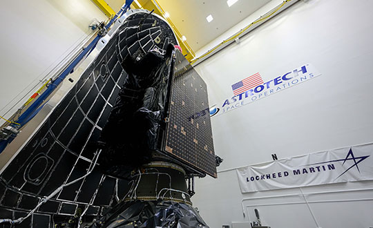
The fifth GPS III satellite was encapsulated within a SpaceX payload fairing on June 9 in preparation for its June 17 launch.
The U.S. Space Force’s Space and Missile Systems Center’s Lockheed Martin-built GPS III Space Vehicle 05 satellite was encapsulated within a SpaceX payload fairing at Astrotech Space Operations Florida facility on June 9 in preparation for launch, scheduled for June 17 from Cape Canaveral Space Force Station.
The 15-minute launch window opens 12:09 p.m. EDT. If SpaceX provides a live feed to view the launch, it will be available here.
Encapsulation of the satellite within the payload fairing protects the satellite from the impact of dynamic pressure and aerodynamic heating during its harrowing journey through the earth’s atmosphere, and supports the ability to communicate with the satellite until separation from the launch vehicle on orbit.
“The GPS III program continues to make strides in modernizing the GPS constellation for the United States Space Force, maintaining the ‘gold standard’ for position, navigation and timing,” said Col. Edward Byrne, Medium Earth Orbit Space Systems division chief, “SV05 is not only the first-ever USSF satellite launched on a previously flown booster, but also is the 24th military-code (M-xode) satellite introduced to our constellation, the last needed to bring M-code to full operational capability.”
GPS III SV05 will join the current 31-satellite operational constellation to continue to provide the gold standard in positioning, navigation and timing services for more than four billion users worldwide.
The Space and Missile Systems Center, located at Los Angeles Air Force Base in El Segundo, California, is the U.S. Space Force’s center of acquisition excellence for acquiring and developing military space systems. Its portfolio includes the development of advanced space and launch capability and systems, global navigation satellite systems, military satellite communications, defense meteorological satellites, space launch and range systems, satellite control networks, space-based infrared systems, and space situational awareness capabilities.
GPS III SV05 is encapsulated within a SpaceX payload fairing at Astrotech Space Operations Florida in preparation for its June 17 launch. (Photo: Lockheed Martin)
GMV has been awarded a contract for the implementation of the Galileo High Accuracy data generator (HADG), which will be the facility in charge of generating the high-accuracy corrections data to enable the provision of the Galileo High Accuracy Service (HAS).
The contract was awarded by the European Union Agency for the Space Programme (EUSPA).
HADG will ensure the continuous provision of HAS data with a proper rate, accuracy, availability, continuity and latency. The data will encompass orbit and clock corrections, biases, quality indicators and service parameters.
The HADG contract addresses a key infrastructure development of the Galileo program. The Galileo HAS, together with the Open Service Authentication (OSNMA) and the Commercial Authentication Service (CAS), is one of Galileo’s stand-out services, setting it apart from GPS or GLONASS.
The HAS will be an open-access service based on the provision of high-accuracy corrections transmitted in the Galileo E6-B signal (E6, data component), at a rate of 448 bps per Galileo satellite connected to an uplink station. The data retrieved by the user from the different satellites offering the HAS will be reconstructed, allowing the user to achieve an improved positioning performance.
As the project’s leader, GMV will be responsible for core project activities such as the provision of the algorithms for the computation of the high-accuracy corrections, which rely on GMV’s MagicPPP software suite for precise point positioning. GMV is supported by SIDERTIA in the area of cybersecurity.
The specification , design and development phases have already been completed, and the project is progressing toward qualification of the system that will enable the execution of the necessary validation activities prior to the HAS initial service declaration, which is expected in 2022.
GMV presented the first version of MagicGNSS in 2008.
On May 10, the Government Accountability Office (GAO) released a report on navigation efforts n the Department of Defense (DOD). Among its findings were that the department regularly fails to establish validated navigation and timing requirements for systems and instead defaults to the capabilities of GPS. Also, that alternate positioning, navigation and timing (PNT) efforts are not prioritized, and sometimes actively opposed, by forces within DOD.
One of the report’s more startling recommendations is that the department change its focus from GPS as the central pillar of its PNT strategy going forward in favor of resilient technologies.
After a panel discussion moderated by Dana A. Goward, president of the RNT Foundation, attendees will have the opportunity to ask questions of the panelists.
The U.S. Office of Management and Budget (OMB) seeks to extend Trump policies and repeal timing law counter to its own study and industry input
The Biden administration’s budget proposal delivered to Congress last week includes $17 million for the small Department of Transportation (DOT) office responsible for leading civil positioning, navigation and timing (PNT) efforts for the nation. This is a marked increase over the $2 million allocated in 2020 and estimated $5 million being spent this fiscal year.
At the same time, it seeks to repeal the National Timing Resilience and Security Act of 2018 that mandated DOT establish a terrestrial timing backup for GPS. This, despite the findings of a recently published RAND study completed for the Department of Homeland Security (DHS), and other input from a telecommunications industry group.
Proposed Spending
The administration’s budget proposes $17 million for the DOT Office of Research and Technology to be split among three areas of effort.
Monitoring and detection. The first is a $3.5 million “(GNSS) performance monitoring and interference detection” project. This is a one-time request that is expected to be followed by a request for $1 million in yearly funding to maintain and operate the capability.
While these may not seem like sufficient funds to many, DOT is tasked with working with other departments and agencies, and to leverage existing capabilities. The National Geospatial-Intelligence Agency (NGA) is specifically named as an important partner with DOT in this effort. NGA already has responsibility for issuing worldwide navigation warnings for U.S. interests. It also has access to a wide variety of information that could be used for the project.
Signal authentication. Another $3.5 million is proposed for Executive Order (EO) 13905 Implementation and GPS Signal Authentication. The EO was issued in February 2020. It seeks to leverage market forces and education to create additional sources of PNT and encourage users to access them. This approach has been criticized by many as unworkable without extensive regulation and mandates for users, while still not addressing the majority of American companies and users.
$1.5 million of this $3.5 million will go to further implement the EO through development of a “PNT threat space model” and otherwise support inter-department PNT profile and research and development efforts.
$2 million would be allocated for a one-time investment in GPS signal authentication to “result in the development and validation of requirements for data and signal authentication capability for civil GPS,” reads the proposal. DOT has regularly requested much greater sums to establish civil signal monitoring, leading many to believe the requirements are already well known. One industry observer suggested this could be “a study in lieu of action.”
GPS Backup. $10 million would be spent for “GPS Backup/Complementary PNT Technologies Research,” essentially follow-on studies to the DOT GPS Backup Technologies Demonstration. “These efforts will further develop PNT modeling, simulation, and testing tools, as well as standards and performance monitoring tools needed to evaluate integration of diverse positioning, navigation, and/or timing technologies into end-user applications. This work will also support development of cyber-secure receivers,” reads the proposal.
One congressional staff member expressed shock at seeing that provision. “The act was the epitome of thoughtful, bipartisan congressional effort,” the staff member said. “It was co-sponsored in the Senate by Markey and Cruz, for crying out loud. You can’t get more bipartisan than that. To have this dumped on us without any notice or consultation is amazing. It is not something I would expect from this White House. I am not sure how serious a proposal it is.”
Some observers on the hill and elsewhere have opined that, rather than the repeal proposal being a well-vetted administration policy, it is an effort by OMB staff held over from the previous administration to carry forward and preserve President Turmp’s Executive Order 13905 and other PNT policies. Rather than focusing on establishing a GPS backup capability, they instead urged PNT users to find and pay for alternatives on their own.
Harsh Tone, False Assertions
Compounding the surprise is the exceptionally harsh tone in the proposal, and assertions that many claim are outright false.
Among the problems with the language seen by observers is its assertion that NTRSA seeks to establish a single backup for GPS services.
“It’s unclear to me where such an assertion is supported in the record,” said Greg Winfree, former Assistant Secretary at DOT in the Obama administration. “NTRSA requires the department to incorporate findings from the GPS back-up demonstration program. That project found a variety of systems are needed to protect America,” he said. “NTRSA does require establishment of at least one system, which is incredibly important. Without at least one alternative in place, GPS is one of highest priority targets for our enemies. We have to get the bullseye off of GPS. NTRSA does that.”
This point on national security was reinforced by Scott Pace, head of the Space Policy Institute at George Washington University (GWU). Pace was executive director for the Space Council in the Trump administration. At a recent GWU webinar on the topic, he commented that having an alternative to GPS will contribute to national security and improve global stability. It will “lower the pressure on us to escalate and respond” should GPS satellites be damaged, or services disrupted, he said.
China, Russia, and other nations have terrestrial PNT alternatives to GNSS already in operation. This imbalance creates strategic and tactical problems for the United States, according to many analysts.
The proposed budget also describes NTRSA’s goal of providing at least one backup as “inefficient, anti-competitive and potentially harmful to the existing market for back-up/complementary PNT services.”
“Exactly the opposite is true,” according to Diana Furchtgott-Roth, GWU economics professor. Until January of this year, she led civil PNT issues within the Trump administration as a Deputy Assistant Secretary for Research and Technology at DOT. “DOT’s Complementary PNT and GPS Backup Technologies Demonstration Report, published in January, specifically stated that a variety of technologies are needed to complement GPS. What is the most cost-efficient in an urban area is not necessarily the most cost-efficient in a rural or maritime area.”
“PNT is a utility used by every American. Having affordable complementary service available to people in rural and urban areas is the height of efficiency. It is unquestionably in the interests of national and economic security. In fact, access to at least one alternative should be free so to encourage adoption and best protect the nation,” she said.
“GPS is now a free service provided by the government, and the government is responsible for making sure that it is reliable. GPS outages would cause harm across a broad range of economic activities, including emergency services, general aviation, pipelines, and the electricity grid,” according to Furchtgott-Roth.
No-So-New and Contradictory Research
The proposal to repeal NTRSA cites “recent federal analyses” as part of its justification. One of these is likely a report done for the Department of Homeland Security (DHS) by the RAND Corporation. Touted in a press release last month as “new research” and labeled “Published 2021,” the work was actually completed in 2019. DHS representatives have said the delay in publication was needed for review and approval.
Yet the report was the basis for a DHS report to Congress submitted in April 2020. This has caused some to opine that its publication was timed to reinforce OMB’s effort to repeal NTRSA. “You don’t submit reports to Congress based on un-reviewed, un-approved material,” said a retired DHS official. “The timing of its release is clearly deliberate.”
At the same time, it found that government investment in a national timing network, such as the one mandated by the NTRSA, is likely warranted. Saying that a complete backup for all GPS services in all parts of the country is not cost-beneficial, the study says there are some “…federal initiatives that do appear to be cost effective or close to cost effective.” These include “Timing-only backup through fiber/FirstNet, eLoran, or STL [Satelles].”
According to the retired DHS official, this directly contradicts OMB’s assertion that NTRSA should be repealed. “Either they didn’t read the whole thing, or they counted on most people not reading farther than the top-level recommendations,” he said. “And those top recommendations were clearly selected to match OMB’s desired outcome.”
Telecommunications Industry Cites Need for NTRSA Provisions
The May 2021 “Report to the President on Communications Resiliency” also runs counter to claims made in the budget proposal. In it, the president’s National Security Telecommunications Advisory Committee (coordinated by DHS) cites the need for GPS alternatives in telecommunications and urges President Biden to fund them. It specifically mentions the need for a national timing architecture, and cites the provisions of NTRSA several times as a step in the right direction.
The industry group Alliance for Telecommunications Solutions also sent letters in May to congressional leaders urging funding for GPS alternatives.
Continuing the Discussion
Congress has become increasingly dissatisfied with executive branch actions on resilient PNT over the last decade.
The most recent evidence of this is an extensive and highly critical report of the Department of Defense’s approach to PNT resilience released May 10 by the Government Accountability Office (GAO). Among its recommendations was to not rely on GPS as a primary PNT source but look to more resilient technologies.
While President Trump’s 2020 Executive Order did not make precisely the same recommendation to civil users, it did focus on “responsible use” of PNT and transitioning to using additional, non-GPS dependent sources.
The question still under discussion is how far the government should go to support such a transition.
Seasoned observers regularly comment that Congress has the “power of the purse” and every president’s budget is “dead on arrival” regardless of which party controls the White House.
It seems clear that resilient PNT will be a topic of lively debate between the Congress and the White House, as well as internally on the hill, for the foreseeable future.
As the number of GNSS constellations and satellites in orbit continues to grow,
will we reach the point of diminishing returns?
Ellen Hall
“More satellites equal more data, and redundant constellation systems — through GNSS interoperability — can give us more robust PNT, as restated in the January Memorandum on Space Policy Directive 7. That said, there are always diminishing returns. Treaties place liability on the launching country if something goes wrong, but with tens of thousands of small satellites expected to be launched over the next decade, it will be getting increasingly crowded. Concerns are growing about the necessity of increased maneuvers to keep these satellites from a chain reaction of collisions, which ultimately could cause debris to fall to inhabited areas of Earth.” — Ellen Hall / Spirent Federal Systems
Jean-Marie Sleewaegen
“With already more than 130 GNSS satellites in orbit, the benefit of new satellites decreases while the risk of satellites interfering with each other increases. However, this is only considering GNSS as we know it, in the MEO orbit (altitude about 22,000 km). The future of GNSS may well be closer to Earth, in the LEO orbit (<1,000 km), with well-known benefits in terms of convergence time and resilience to jamming. Sooner than later, we can expect constellations of hundreds or thousands of LEO satellites carrying a GNSS-like payload supporting PNT services. No worries, there is still growth potential!” — Jean-Marie Sleewaegen / Septentrio
Stuart Riley
“With the current four GNSS constellations and a typical survey elevation mask of 10˚in North America, we average around 30 visible satellites. Far more are visible in Asia with the addition of the regional systems. In an area with a clear view of the sky, this provides more than enough satellites for precision centimeter positioning. However, most professional GNSS users do not have the luxury of operating exclusively in open areas with ideal conditions. Accessing many satellites across multiple constellations increases the probability of receiving sufficient satellites that produce high-quality measurements in obstructed areas. As the constellations expand, we observe improvement in precision position availability in these locations. The large number of satellites, coupled with independence across the four systems, improves system integrity and continuity while also helping to reduce the converge time in PPP solutions.” — Stuart Riley / Trimble
Bernard Gruber
“In a utopian vision of navigation, data gluttons and like-users of GNSS would say that there will never be enough! If capabilities remained static, then yes, I believe we would reach the point of diminishing returns. I would offer that innovation and competition will continue to drive capability improvements via power, signal quality, coverage, integrity and clock/timing accuracy. These innovations, coupled with user equipment flexibility utilizing signals from space, will drive an ever-maturing market balance and increasing return.” — Bernard Gruber / Northrop Grumman
Thales Alenia Space, a joint venture between Thales (67%) and Leonardo (33%), has been selected by the European Commission for a new strategic contract to assess the feasibility of an integrity service to complement the European Global Navigation Satellite System (EGNSS) High Accuracy service, which will pave the way for use in autonomous vehicles.
Thales Alenia Space will focus on the development of a sensor-fusion approach, including and complementing evolutions of EGNSS High Accuracy. These service evolutions are aimed at providing the integrity level to serve the high-reliability and high-accuracy positioning needs of new, demanding applications such as autonomous vehicles on the road and autonomous transport in the maritime and rail sectors.
With this contract, Thales Alenia Space will assess the extension of the integrity and safety-of-life services for aviation into the road, rail and maritime sectors. In 2020, the company won the EPICURE project, based on an integrity concept for road travel (tolls and insurance), as well as the IMPRESS project, targeting an integrity service for rail signaling and train separation.
Thales Alenia Space has been a prime contractor for EGNOS (European Geostationary Navigation Overlay Service) for 25 years. It is a lead industrial contributor to the Galileo system and its ground mission segment and responsible for providing six Galileo Second Generation satellites. In April, the company was awarded a contract to support the implementation and experimentation of the navigation algorithms that will be used in the Galileo Second Generation program.
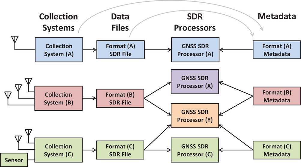
The GNSS Software Defined Radio Metadata Standard document has been published in NAVIGATION: Journal of the Institute of Navigation’s Spring 2021 issue, Volume 68, No. 1, pp. 11-20.
The metadata standard is the product of a three year-long effort of the ION GNSS SDR Standard Working Group and defines the parameters and schema to express the contents of SDR sample data files. The standard promotes the interoperability of GNSS SDR data-collection systems and processors.
In the past several years there has been a proliferation of software-defined radio (SDR) data-collection systems and processing platforms designed for or applicable to satellite navigation applications. These systems necessarily produce datasets in a wide range of different formats.
To correctly interpret this SDR data, essential information such as the packed sample format and sampling rate is needed. Communicating this metadata between creators and users has historically been an ad-hoc, cumbersome, and error-prone process.
To address this issue, the satnav SDR community developed the metadata standard and normative software library to automate the process, thus simplifying the exchange of datasets and promoting the interoperability of satnav SDR systems.
The standard was ratified and formally accepted as an Institute of Navigation Standard in January.
The formal standards document export citation is here.
Illustration of ad-hoc metadata exchange between SDR data creators and users. (Image: NAVIGATION)
19% of tracked space objects threaten GPS and other GNSS satellites. While there are many fewer objects in MEO than in LEO, the risk in the former is arguably greater because GPS is so critical to almost all of our technology.
The Risk
GNSS satellites, especially GPS satellites, are critical to the well-being and smooth functioning of economies and national security. This is especially true in Europe and the United States, which do not have complementary terrestrial systems able to provide vital positioning, navigation and timing (PNT) services when signals from space are not available.
While the probability of debris damage to GNSS in medium Earth orbit (MEO) is much less than for satellites in low Earth orbit (LEO), the consequences of such an event would be much, much higher. The loss of one satellite would be a concern; that of multiple satellites, a major problem. The unthinkable chaos, national security damage, and severe economic impacts to the $21 trillion U.S. GDP make the risk unacceptable.
For those who think we need not worry about the low probability of collisions at MEO, the Galileo collision avoidance maneuver in March 2021 should be a wakeup call. The problem is here. We need to act now.
Background
Much like a nuclear fission reaction, the problem of space debris starts small then grows exponentially, as each collision creates more pieces that, in turn, can collide with other objects.
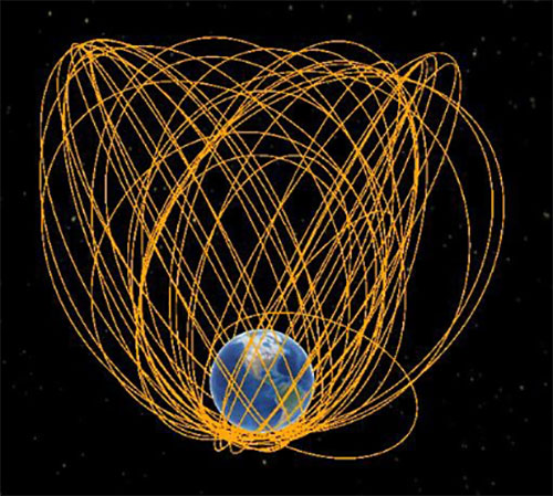
The MEO debris environment is 100 times less dense than the LEO. The spatial density of orbital debris in LEO (up to 2,000 km), shown in Figure 1, suggests that LEO is the likely location where a runaway chain reaction will initiate. This could easily result in a region of space so dangerous that it would effectively deny access to MEO, where the GPS constellation resides.
While the debris situation at MEO is much better, there are still 4,021 tracked debris objects that could impact GPS and other GNSS satellites. Because future orbital debris collisions in LEO will be responsible for more debris in MEO, the situation is guaranteed to get worse. The dead and debris objects in highly elliptical, or Molniya, orbits, shown in Figure 2, could be responsible for such collisions pushing LEO debris into MEO.
Contributions to the general MEO debris population come from launch systems and other factors. Early GPS satellites (Block II/IIA/IIR) used internal orbital-insertion motors to avoid leaving uncontrolled stages in the operational orbit range when moving from transfer orbit to MEO. For survivability reasons, they were also deployed with sufficient fuel to make several major orbital moves. Unfortunately, later versions used separate orbital-insertion stages, which were left drifting in the orbital neighborhood and carried less fuel, resulting in fewer possible maneuvers to avoid collisions.
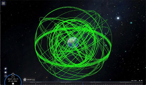
Using the CelesTrak visualization interface to extract space situational awareness data captured by the Combined Force Space Component Command’s 18th Space Control Squadron (18 SPCS) reveals a much more dire image of MEO. Of the 21,266 total tracked objects in Earth’s orbit, 157 are active GNSS satellites, as shown in Figure 3.
Figure 3. Active GNSS satellites. (Image: Celestrak)
However, a total of 4,021 objects reside or pass through MEO, which are either active (331), dead (668), debris (1,761), rocket bodies (1,100) or unknown (161) objects, as shown in this video.
These 4,021 objects represent 19% of the total number of tracked objects from the 18 SPCS space catalog. While the total 21,266 tracked objects is a far cry from the 100 million objects NASA’s Orbital Debris Program Office represents, one can imagine that a significant portion of untracked debris objects, under 10 cm in size, reside or pass through MEO as well. This is significant, according to NASA, which says that objects with a diameter of 1 cm to 10 cm are the most dangerous due to the lack of tracking data, which essentially makes them invisible.
False Sense of Security
The growing orbital-debris concern is a threat too big to ignore. Unfortunately, to date attempts to manage space traffic have amounted to passive measures, such as establishing policy, characterizing the environment, and creating orbital protection guidelines. Even the highly touted, $6 billion U.S. “Space Fence” is a passive measure that contributes nothing active to solve the problem. Not at all a “fence,” it is merely a way to detect the larger and more dangerous debris.
These efforts may, in all actuality, be counterproductive if they instill a false sense of security in the public and government leaders that the problem is being adequately addressed.
A Proactive Solution
Since 1978, the orbital debris population has been touted as our biggest space problem. It is important to do as much as we can with policies and procedures to keep the problem from getting worse faster. However, even if we humans were to completely resist our seemingly natural impulse to pollute everywhere we go, collisions with existing debris would continue to increase the number of dangerous objects in orbit.
Active debris removal (ADR) is the only solution. The sooner it begins, the safer we will all be. Like the oceans and cyberspace, orbital space suffers from the tragedy of the commons. Everyone wants to use it, but no one owns it. No one is responsible for ensuring it is cared for and maintained. As a result, user behavior is difficult to control, and the environment often suffers. Government action, presumably supporting the best interests of all users, is the default answer.
The proposed Space Debris Act of 2021 is a great start. It paves the way for persistent funding and creates an industry responsible for safeguarding humanity’s orbital infrastructure. It would introduce tax credits to incentivize non-government funding contributions and reduce the price of debris removal, so that satellite operators and the emerging space tourism industry can afford to clean up space where they plan to operate.
The bill is currently being presented by OrbitGuardians to members of Congress for sponsorship. Organizations wishing to support these efforts should contact Ken Eppens at OrbitGuardians at [email protected].
GPS/GNSS and other critical space assets are at an unacceptable level of risk from debris. It is time to safeguard orbital infrastructure to protect the interests of the United States and humanity’s future in space.
The Indian Institute of Technology (IIT) Roorkee is offering a free online course on GNSS and Applications on the NPTEL platform. The four-week course will provide a basic understanding about digital elevation models (DEMs) and their applications in civil engineering and Earth sciences.
During the course, various DEMs and their sources, generation techniques, derivatives, errors and limitations will be discussed extensively. Surface hydrologic modeling using DEMs, modeling derivatives and their applications will also be discussed.
Intended audience. Under- and post-graduate engineering and post-graduate science students and faculty.
Pre-requisites. Current students of engineering, post-graduate science students and Ph.D. students should have basic knowledge of geographic information systems (GIS) and remote sensing.
Industry support. Geoinformatics companies (such as NIIT, Esri India, Leica Geoinformatics, MapmyIndia, ISRO and more).
The course will be taught by Arun K. Saraf, professor in the Department of Earth Sciences at IIT Roorkee. He teaches courses on remote sensing, digital image processing, GIS, advanced GIS, geomorphology and related topics to undergraduate and postgraduate students of Geological Technology and Applied Geology. He has a Ph.D. in remote sensing from the University of Dundee, United Kingdom.
The course takes place July 26-August 20. Registration is open until August 2 and can be done through the SWAYAM platform.
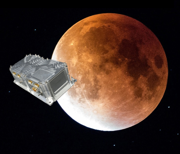
Swiss company SpacePNT will develop an advanced spaceborne GPS/Galileo receiver to demonstrate for lunar navigation and positioning.
A vision of the NAVIMOON receiver. (Image: SpacePNT)
The European Space Agency (ESA) has selected SpacePNT to develop an advanced spaceborne GPS/Galileo receiver to demonstrate the use of terrestrial satellite navigation signals or real-time and autonomous orbit determination and positioning, navigation and timing (PNT).
The receiver will be carried aboard the ESA-SSTL Lunar Pathfinder spacecraft, which will be placed in orbit around the Moon.
The contract includes the development, qualification and delivery of one proto-flight model (PFM) and two engineering models of the NAVIMOON receiver. NAVIMOON is the high-sensitivity version of SpacePNT’s NAVILEO high-performance GNSS spaceborne receiver.
The NAVIMOON receiver implements high-sensitivity algorithms able to receive and process signals extremely attenuated coming from the spillover (side lobes) around the Earth of signals transmitted by satellite navigation systems. It combines these signals’ measurements with advanced on-board orbital filters to achieve onboard the spacecraft in real time an unprecedented target orbit determination accuracy of 100 meters root-mean-square (rms) at Moon altitude, which is well above the typical accuracy that can be achieved with terrestrial radio ranging that involves the use of costly deep-space-station ground infrastructures.
Given the high interest in Moon exploration and colonization (more than 50 commercial and governmental missions have been announced between now and 2024), it is expected that this NAVIMOON receiver technology will play a significant role in the next decade not only on Earth-Moon transfer orbits, but also to provide enhanced PNT services for users on the Moon. Deployment of a lunar constellation will allow the provision of lunar navigation in Moon-obstructed areas.
For this project, SpacePNT will partner with EECL from the UK. EECL will work as a subcontractor and bring significant space expertise to the electronics design, manufacturing and qualification of the receiver.
BAE Systems Inc. has received a $325.5 million contract from the Defense Logistics Agency for advanced military code (M-code) GPS modules that will provide reliable and secure positioning, navigation and timing data with anti-jamming and anti-spoofing capabilities.
The modules will help warfighters conduct operations in contested electronic warfare environments.
“Our state-of-the-art GPS technology works with the advanced military M-code signal to provide reliable information to the warfighters who depend on it,” said Greg Wild, director of Navigation and Sensor Systems at BAE Systems. “This contract will ensure the availability of M-code module inventory to build advanced, next-generation GPS receivers.”
Under the multi-year contract, BAE Systems will deliver Modernized GPS User Equipment (MGUE) Increment 1 Common GPS Modules (CGMs) compatible with the advanced M-code signal to support the U.S. Department of Defense and international allies through 2030.
BAE Systems will manufacture the modules, manage their inventory on behalf of the Defense Logistics Agency, and use them to build military-grade GPS receivers for ground and precision-guided munitions.
BAE Systems’ portfolio of M-code GPS receivers provides flexible, efficient, and reliable navigation and guidance solutions for airborne systems, precision munitions, handheld receivers, and embedded applications.
The European Commission and the European Space Agency (ESA) have selected Orolia to provide the core GNSS simulation engine for the Galileo Second Generation (G2G) RF Constellation Simulator (G2G RFCS).
While the first launched Galileo satellites are reaching the end of their theoretical operational life, the G2G initiative includes the preparation of a future generation of Galileo global infrastructure, from satellites to ground segments, to maintain current services as well as provide improved performance and Required Navigation Performance (RNP) features to all users.
In this context, Orolia has been selected to participate in the G2G RFCS activity, which will support G2G signals evolution requirements.
The primary objective of the G2G RFCS initiative is to design, develop, manufacture and test an enhanced radio-frequency constellation simulator dedicated to Galileo engineering and experiments. This simulation technology will enable scientists and industries to verify, demonstrate and validate the future G2G configuration.
To meet these requirements, Orolia will provide the core GNSS simulation engine based on its Skydel software technology, within a custom hardware configuration, to simulate all Galileo signals including Open Service (OS) and Public Regulated Service (PRS). Orolia’s GNSS simulators offer the high-end performance level and flexibility required to configure this new testing infrastructure in a software-defined solution.
“With this project, Orolia demonstrates the Skydel platform’s exceptional flexibility to meet critical application requirements and serve as the core engine to design the next generation of GNSS signals,” said Orolia CEO Jean-Yves Courtois. “We are very proud to work with ESA, GMV and Tecnobit to help develop the next generation European Galileo constellation.”