Category: GNSS

  • Next 10 years of EGNOS to focus on drones

    Next 10 years of EGNOS to focus on drones

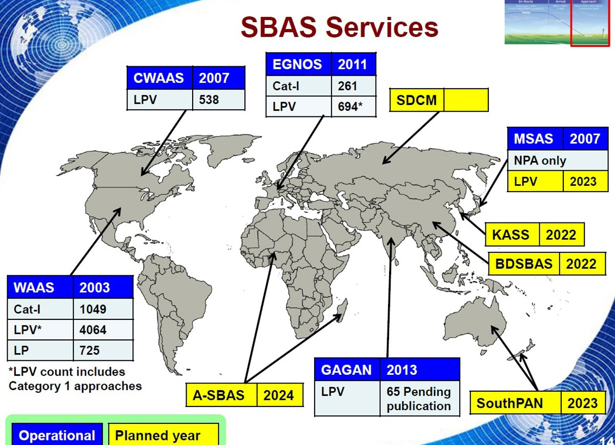
    Europe’s EGNOS satnav system has been providing safety-of-life services for 10 years. EGNOS, the European Geostationary Navigation Overlay Service, transmits signals from a duo of satellite transponders in geostationary orbit.

    The satellite-based augmentation system (SBAS) gives additional precision to U.S. GPS signals, delivering an average precision of 1.5 meters over European territory, as much as a 10-fold improvement over unaugmented signals. EGNOS also provides confirmation of GPS signal integrity through additional messaging identifying any residual errors.

    While the EGNOS Open Service has been in general operation since 2009, EGNOS began its safety-of-life service in March 2011.

    The European Space Agency (ESA) designed EGNOS as the European equivalent of the U.S. Wide Area Augmentation System (WAAS), working closely with the European air traffic management agency Eurocontrol. ESA then passed EGNOS to the European GNSS Agency (GSA) to run operationally.

    Guiding airliners

    EGNOS’s primary customer is aircraft. Without guidance from the ground, pilots using EGNOS can confidently descend in bad weather to 60 meters’ altitude before needing to make visual contact with the tarmac.

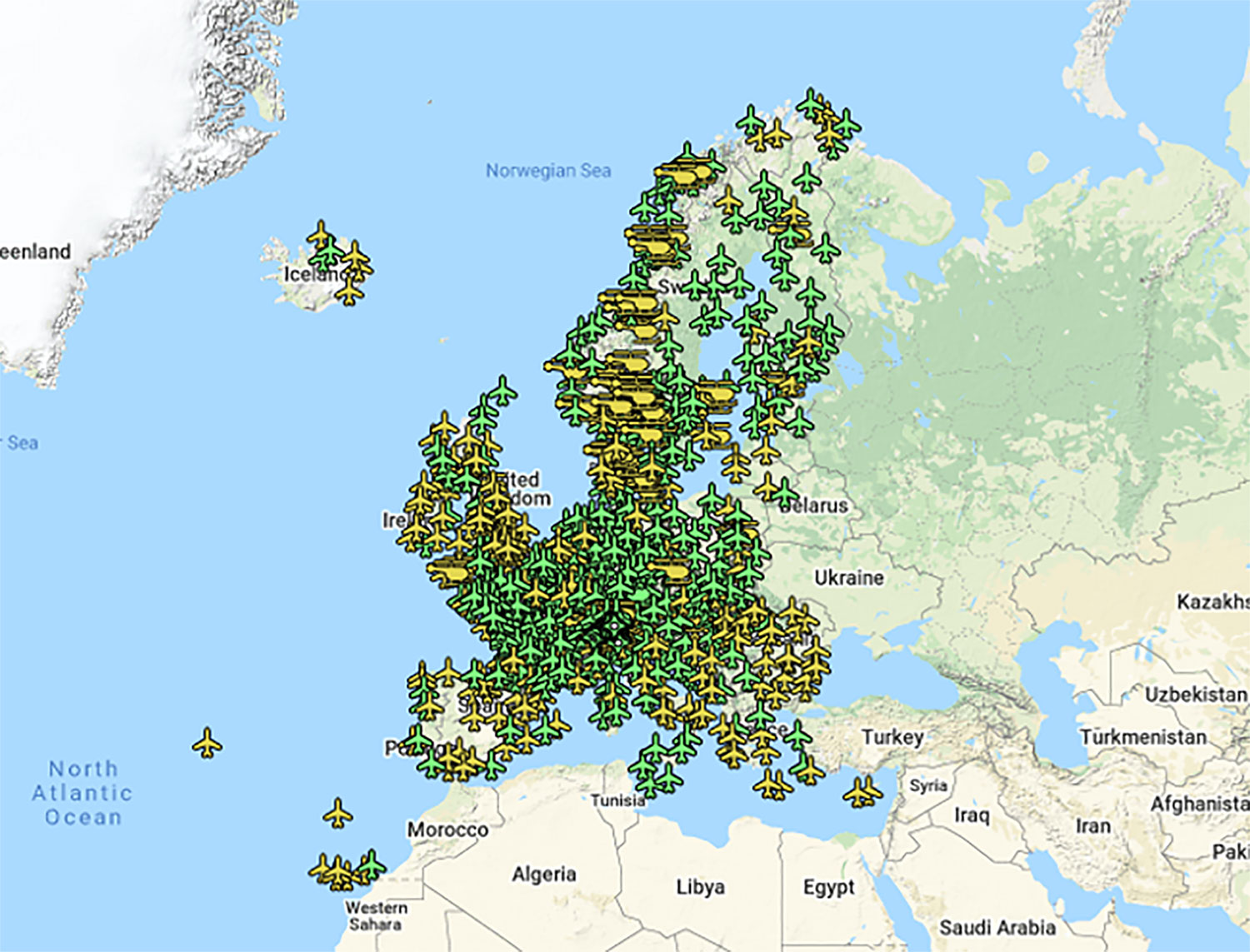
    On March 17, 2011, France’s Pau Pyrénées Airport was the first airport to use EGNOS. Today, more than 385 airports and helipads and 60 airlines across Europe use EGNOS-based LPV-200 approaches (short for Localizer Performance with Vertical guidance – 200 feet). The EGNOS service requires no ground equipment, and replaces the radio guidance beamed upward by traditional CAT I instrument landing system (ILS) infrastructure with no decrease in performance.

    As of March 2021, more than 385 airports and helipads and 60 airlines across Europe are using EGNOS-based LPV-200 approaches. (Image: ESA)
    As of March 2021, more than 385 airports and helipads and 60 airlines across Europe are using EGNOS-based LPV-200 approaches. (Image: ESA)

    Serving drones

    EGNOS is now being eyed as the enabler of unmanned aerial vehicles (UAVs). The GSA has supported numerous trials of drones equipped with EGNOS as well as Galileo through its EGNSS4RPAS project. Crewed aircraft are expected to be vastly outnumbered in our skies by all kinds of UAVs, employed for everything from weather and environmental monitoring to personalized delivery services.

    U-Space is Europe’s program to integrate drones into the airspace. (Image: ESA)
    U-Space is Europe’s program to integrate drones into the airspace. (Image: ESA)

    The traditional person-based air traffic control model will need to evolve to accommodate such a shift, based on automated monitoring, traffic management and collision avoidance. In Europe, this highly automated version of air traffic control is termed U-space.

    EGNOS’s safety-of-life service is essential to making this happen, moving from today’s situation — where drones are limited to specific air corridors and line-of-sight operations — to let them roam freely but safely in busy airspace and built-up areas.

    “The whole idea behind EGNOS’s safety-of-life has been to render satellite navigation sufficiently reliable for any kind of use,” explained Didier Flament, who leads ESA’s EGNOS team. “After 10 years of faultless operations, new applications are becoming plain. Drone flight is one example. EGNOS is also being evaluated for train positioning as well as assisted and autonomous automobile driving.”

    EGNOS, the next generation

    ESA retains responsibility for the system’s evolution, and the middle of this decade should see the debut of its new generation, EGNOS v3.

    “While the current system only works with single-frequency GPS signals, EGNOS v3 will operate on a multi-frequency, multi-constellation basis, able to augment all available satellite signals in both L1 and L5 bands, including Galileo,” Didier said. “The result will be far enhanced performance and reliability.

    “In addition, we are working with developers of other SBAS around the globe to ensure they stay fully interoperable so for instance EGNOS-equipped aircraft can fly between continents on a seamless basis. Such interoperability, combined with the arrival of the other SBAS systems under development in other regions, will lead to a quasi-global worldwide safety-of-life service coverage in the year 2030.”

    Operational and planned satellite-based augmentation systems (SBAS) around the globe. (Image: ESA)
    Operational and planned satellite-based augmentation systems (SBAS) around the globe. (Image: ESA)
  • NASA analyzes navigation needs of Artemis Moon missions

    NASA analyzes navigation needs of Artemis Moon missions

    Space communications and navigation engineers at NASA are evaluating the navigation needs for the Artemis program, including identifying the precision navigation capabilities needed to establish the first sustained presence on the lunar surface.

    “Artemis engages us to apply creative navigation solutions, choosing the right combination of capabilities for each mission,” said Cheryl Gramling, associate chief for technology in the Mission Engineering and Systems Analysis Division at Goddard Space Flight Center in Greenbelt, Maryland. “NASA has a multitude of navigation tools at its disposal, and Goddard has a half-century of experience navigating space exploration missions in lunar orbit.”

    Alongside proven navigation capabilities, NASA will use innovative navigation technologies during the upcoming Artemis missions.

    “Lunar missions provide the opportunity to test and refine novel space navigation techniques,” said Ben Ashman, a navigation engineer at Goddard. “The Moon is a fascinating place to explore and can serve as a proving ground that expands our navigation toolkit for more distant destinations like Mars.”

    Illustration of NASA's lunar-orbiting Gateway and a human landing system in orbit around the Moon. (Image: NASA)
    Illustration of NASA’s lunar-orbiting Gateway and a human landing system in orbit around the Moon. (Image: NASA)

    Ultimately, exploration missions need a robust combination of capabilities to provide the availability, resiliency, and integrity required from an in-situ navigation system. Some of the navigation techniques being analyzed for Artemis include the following.

    Radiometrics, optimetrics and laser altimetry

    Radiometrics, optimetrics, and laser altimetry measure distances and velocity using the properties of electromagnetic transmissions. Engineers measure the time it takes for a transmission to reach a spacecraft and divide by the transmission’s rate of travel — the speed of light.

    These accurate measurements have been the foundation of space navigation since the launch of the first satellite, giving an accurate and reliable measurement of the distance between the transmitter and spacecraft’s receiver. Simultaneously, the rate of change in the spacecraft’s velocity between the transmitter and spacecraft can be observed due to the Doppler effect.

    Radiometrics and optimetrics measure the distances and velocity between a spacecraft and ground antennas or other spacecraft using their radio links and infrared optical communications links, respectively. In laser altimetry and space laser ranging, a spacecraft or ground telescope reflects lasers off the surface of a celestial body or a specially designated reflector to judge distances.

    The Lunar Orbiter Laser Altimeter (LOLA) aboard the Lunar Reconnaissance Orbiter (LRO) sends laser pulses down to the surface of the Moon from the orbiting spacecraft. These pulses bounce off of the Moon and return to LRO, providing scientists with measurements of the distance from the spacecraft to the lunar surface. As LRO orbits the Moon, LOLA measures the shape of the lunar surface, which includes information about the Moon's surface elevations and slopes. This image shows the slopes found near the South Pole of the Moon. (Image: NASA/LRO)
    The Lunar Orbiter Laser Altimeter (LOLA) aboard the Lunar Reconnaissance Orbiter (LRO) sends laser pulses down to the surface of the Moon from the orbiting spacecraft. These pulses bounce off of the Moon and return to LRO, providing scientists with measurements of the distance from the spacecraft to the lunar surface. As LRO orbits the Moon, LOLA measures the shape of the lunar surface, which includes information about the Moon’s surface elevations and slopes. This image shows the slopes found near the South Pole of the Moon. (Image: NASA/LRO)

    Optical navigation

    Optical navigation techniques rely on images from cameras on a spacecraft. There are three main branches of optical navigation.

    • Star-based optical navigation uses bright celestial objects such as stars, moons, and planets for navigation. Instruments use these objects to determine a spacecrafts’ orientation and can define their distance from the objects using the angles between them.
    • As a spacecraft approaches a celestial body, the object begins to fill the field of view of the camera. Navigation engineers then derive a spacecraft’s distance from the body using its limb — the apparent edge of the body — and centroid, or geometric center.
    • At a spacecraft’s closest approach, Terrain Relative Navigation uses camera images and computer processing to identify known surface features and calculate a spacecraft’s course based on the location of those features in reference models or images.

    NASA will use data gathered from LuGRE to refine operational lunar GNSS systems for future missions.


    Weak-signal GPS and GNSS

    NASA is developing capabilities that will allow missions at the Moon to leverage signals from GNSS constellations. These signals — already used on many Earth-orbiting spacecraft — will improve timing, enhance positioning accuracy, and assist autonomous navigation systems in cislunar and lunar space.

    In 2023, the Lunar GNSS Receiver Experiment (LuGRE), developed in partnership with the Italian Space Agency, will demonstrate and refine this capability on the Moon’s Mare Crisium basin. LuGRE will fly on a Commercial Lunar Payload Services mission delivered by Firefly Aerospace of Cedar Park, Texas. NASA will use data gathered from LuGRE to refine operational lunar GNSS systems for future missions.

    Illustration of Firefly Aerospace’s Blue Ghost lander on the lunar surface. The lander will carry a suite of 10 science investigations and technology demonstrations to the Moon in 2023 as part of NASA's Commercial Lunar Payload Services (CLPS) initiative. (Image: Firefly Aerospace)
    Illustration of Firefly Aerospace’s Blue Ghost lander on the lunar surface. The lander will carry a suite of 10 science investigations and technology demonstrations to the Moon in 2023 as part of NASA’s Commercial Lunar Payload Services (CLPS) initiative.

    Autonomous navigation

    Autonomous navigation software leverages measurements like radiometrics, celestial navigation, altimetry, terrain-relative navigation, and GNSS to perform navigation onboard without contact with operators or assets on Earth, enabling spacecraft to maneuver independently of terrestrial mission controllers. This level of autonomy enables responsiveness to the dynamic space environment.

    Autonomous navigation can be particularly useful for deep space exploration, where the communications delay can hamper in-situ navigation. For example, missions at Mars must wait eight to 48 minutes for round trip communications with Earth depending on orbital dynamics. During critical maneuvers, spacecraft need the immediate decision-making that autonomous software can provide.

    LunaNet navigation services

    LunaNet is a unique communications and navigation architecture developed by NASA’s Space Communications and Navigation (SCaN) program. LunaNet’s common standards, protocols, and interface requirements will extend internetworking to the Moon, offering unprecedented flexibility and access to data.

    For navigation, the LunaNet approach offers operational independence and increased precision by combining many of the methods above into a seamless architecture. LunaNet will provide missions with access to key measurements for precision navigation in lunar space.

    Artist's conceptualization of Artemis astronauts using LunaNet services on the Moon. a unique approach to lunar communications and navigation. The LunaNet communications and navigation architecture will enable the precision navigation required for crewed missions to the Moon and place our astronauts closer to scientifically significant lunar sites, enhancing the our missions’ scientific output. (Image: NASA/Resse Patillo)
    Artist’s conceptualization of Artemis astronauts using LunaNet services on the Moon, a unique approach to lunar communications and navigation. The LunaNet communications and navigation architecture will enable the precision navigation required for crewed missions to the Moon and place our astronauts closer to scientifically significant lunar sites, enhancing the our missions’ scientific output. (Image: NASA/Resse Patillo)
  • Galileo satellite performs collision avoidance maneuver

    Galileo satellite performs collision avoidance maneuver

    In a first for Galileo, a satellite performed a collision-avoidance maneuver to avoid space debris.

    Under the management of the European GNSS Agency (GSA), the maneuver for satellite GSAT0219 was performed March 6 following a collision risk alert received from EU Space Surveillance and Tracking (EUSST).

    Event timeline. (Image: EUSST)
    Event timeline. (Image: EUSST)

    On Feb. 25, the Galileo Service Operator (GSOp) received from EUSST a collision risk alert between GSAT0219 and an inert Ariane 4 upper stage launched in 1989. Following the warning, GSOp closely monitored the risk, in close cooperation with EUSST that was refining its predictions.

    In line with operational procedures, GSOp informed the GSA of the situation. In a joint effort with the European Commission, the GSA managed the follow-up activities. The effective cooperation between EUSST and the GSA/GSOp was instrumental to the success of the mission and bears testimony to the need for efficient cooperation between different organizations in the space sector.

    Maneuver Authorized

    Following refinement of the Ariane 4 orbit, the risk of collision was still unacceptably high. After assessment of different strategies and associated risks on the service provision, the GSA authorized the execution of an avoidance maneuver.

    The satellite was taken out of service on March 5, and users were informed via NAGU #2021009. The collision avoidance maneuver was performed shortly thereafter, by temporarily relocating the satellite away from its nominal position.

    Satellite GSAT0219 was reintroduced into service on March 19 after the completion of two station-keeping maneuvers to reposition it into its nominal operational orbit.  A second NAGU advised users that the satellite was once again available.

    Map of sensors contributing to the event. (Image: EUSST)
    Map of sensors contributing to the event. (Image: EUSST)


    Feature image: ESA

  • Advanced Navigation to create inertial solution for NASA’s Artemis

    Advanced Navigation to create inertial solution for NASA’s Artemis

    Advanced Navigation, in partnership with quantum technology company Q+CTRL, will create a quantum-enhanced inertial navigation solution for space launch vehicles, satellites and landers. The design of this inertial navigation technology for long-endurance space missions will be pivotal to NASA’s space exploration initiative, the Artemis Lunar Exploration Program.

    The work will be done under a Moon to Mars Supply Chain Capability Improvement grant by the Australian federal government.

    The quantum-enhanced navigation system will enable NASA and its partners in the international space exploration community to execute deep space, lunar and planetary missions that were previously not possible.

    Artemis is NASA’s human lunar exploration plan, with the program aiming to send the first woman and next man to the surface of the Moon by 2024. Scientists have long acknowledged the Moon as a rich source of information regarding Earth and the Solar System. Using the findings from the Moon. NASA will then prepare to launch missions to Mars.

    To meet NASA’s space exploration initiatives, high-end, highly accurate inertial navigation technology is vital to the mission’s success. The groundbreaking inertial navigation systems developed by Advanced Navigation have been recognised by the international aerospace community as a superior technology to help pioneer a new age of space exploration and discovery for humanity.

    For Advanced Navigation, this is just the beginning. “In the long-term view of this critical initiative, team activities following this project will establish an ongoing manufacturing opportunity and capacity that is central to the emerging Australian space industry,” said Chris Shaw, co-CEO of Advanced Navigation.

    Advanced Navigation was founded in Sydney in 2012 by engineers Xavier Orr and Chris Shaw to commercialize thesis research into AI neural network-based inertial navigation. The first product met the market with great success and the company expanded rapidly adding a portfolio of navigation offerings and moving into a diverse range of deep tech fields such as underwater acoustics, GPS, radio frequency systems, sensors and robotics.

    Today Advanced Navigation is a supplier to companies including Airbus, Boeing, Tesla, Google, Apple and General Motors. Advanced Navigation is headquartered in Sydney with a large research facility in Perth and sales offices around the world.


    Feature image: NASA

  • South Korean satellite uses navigation receiver from RUAG Space

    South Korean satellite uses navigation receiver from RUAG Space

    Photo: RUAG Space
    Photo: RUAG Space

    On March 20, a South Korean Earth Observation satellite will be sent to space, carrying a navigation receiver from RUAG Space to determine the satellite’s position in orbit. The Earth Observation satellite is being launched by the Korea Aerospace Research Institute (KARI), South Korea’s space agency.

    The precision single-frequency low Earth orbit GNSS receiver, called LEORIX, is a GPS + Galileo receiver from RUAG Space’s new generation of receivers.

    More than 80 RUAG Space receivers of the latest generation (LEORIX for Low Earth Orbit, GEORIX Geostationary Orbit and PODRIX) have been ordered by customers in Asia, Europe, Middle East and the United States. They will be launched for various low and geostationary Earth Orbit missions within the next few months and years.

    Currently, 22 navigation receivers from RUAG Space are in orbit. The satellite CAS-500-1 will be launched aboard a Russian Soyuz-2 launch vehicle from the spaceport in Baikonur, Kazakhstan.

    After the launch of CAS-500-1, South Korea plans to send the CAS500-2 satellite to space. A launch date of this second mission is not yet defined. The CAS500-2 mission also will fly with a LEORIX receiver from RUAG Space. The satellite builder — Korea Aerospace Industries (KAI) — already has received the space-borne navigation receiver.

    PODRIX in Space

    Since November 2020, two new Precise Orbit Determination Receivers (PODRIX) from RUAG Space have been in orbit. They determine the position of ocean-monitoring satellite Sentinel-6.

    The PODRIX GNSS spaceborne receiver achieves a very high, real-time in-orbit accuracy of the satellite’s position in orbit from below one meter to a few centimeters using on-ground post-processing. The high accuracy is achieved through simultaneously processing of multi-frequency signals from GPS and Galileo.

    PODRIX GNSS spaceborne receivers are built on the experience of the more than 20 GPS-only receivers of the RUAG Space legacy receiver generation now in orbit.

    The receivers precisely determine the position of a satellite once in orbit, which improves the satellite’s performance. Sentinel-6 measures the sea level on a global scale with unprecedented accuracy, which is crucial for climate change research. Every millimeter or centimeter in further precision highly improves the performance of the mission. The more precise the Sentinel-6 spaceborne GNSS receiver from RUAG Space works, the more precise are the data of this climate mission.

    RUAG Space is a supplier to the space industry in Europe, and has a growing presence in the United States. It develops and manufactures products for satellites and launch vehicles, playing a key role both in the institutional and commercial space market. RUAG Space is part of RUAG International, a Swiss technology group focusing on the aerospace industry.

  • Editorial Advisory Board PNT Q&A: Lessons from Galileo and BeiDou

    What is the single most valuable lesson GPS can learn from Galileo and/or BeiDou?

    Bernard Gruber
    Bernard Gruber

    Service continuity. Given that GNSS are so ubiquitous today, similar to the electrical grid, it is imperative that GPS continue the superb system of outage reporting via NANUs, transparency via GPS.gov, and statutory commitments via U.S. Code. Aligning to the U.S. commitment, continued Open Service Signal-in-Space, such as GPS-Galileo-BeiDou, allows thousands of planned and interoperable “apps” such as Google Maps and Waze to thrive. Although not directly in line with the question, terrestrial timing backup systems, similar to what China and some other countries do, is a valuable lesson in continuity from BeiDou.

    Bernard Gruber
    Northrop Grumman


    Ellen Hall
    Ellen Hall

    Perhaps the lesson could be, ‘It’s easier not to be first!’ Newer navigation constellations have the benefit of watching and learning from GPS — things done well and things to improve. From technology to operational procedures, a global navigation satellite system (GNSS) is difficult to execute. Would it have been easier or cost less if the United States had decided to land on the Moon after someone else had paved the way? Probably, but there is something very satisfying about being first! And, despite the fact that GPS satellites outlive their life expectancy, we keep launching new ones, with improved technology, to give the world better accuracy and more robust signals. The world of navigation welcomes Galileo, BeiDou, and all the others to follow.

    Ellen Hall
    Spirent Federal Systems


    Alison Brown
    Alison Brown

    “GPS could benefit from lessons learned from BeiDou as to the importance of resilience in providing PNT services. BeiDou has a total of 42 satellites now in operation and open signals are broadcast on six frequencies (B1I, B1C, B2I, B2a, B2b, and B3I). In comparison, GPS has currently 29 operational satellites and provides open signals on three frequencies (L1, L2, L5). As the global threat to GPS grows, from frequency incursions by evolving 5G systems as well as deliberate interference or spoofing, the ability to operate on different frequencies to provide resilience against harmful interference will become increasingly important.”

    Alison Brown
    NAVSYS Corporation 


    Jean-Marie Sleewaegen
    Jean-Marie Sleewaegen

    “While GPS remains a gold standard with decades of reliable service, the advent of BeiDou and Galileo has undoubtedly stirred up competition. While BeiDou is exceptionally fast at deploying new signals and services, Galileo is now transmitting the first ever authenticated OSNMA signals, helping secure GNSS receivers against spoofers. The main lesson is that it is better to have company than to be alone. Having multiple GNSS not only increases the number of satellites and signals, which improves positioning accuracy and reliability, but more importantly, it fosters continuous innovation, for the benefit of all users.”

    Jean-Marie Sleewaegen
    Septentrio

  • SyncServer S600 now defends against GPS jamming, spoofing

    SyncServer S600 now defends against GPS jamming, spoofing

    Photo: Microchip
    Photo: Microchip

    Microchip Technology has integrate its BlueSky technology signal-anomaly detection software into its SyncServer S600 Series network time server and instruments.

    The SyncServer S600 Series now provides GPS jamming and spoofing detection and protection, in combination with local radio frequency (RF) data logging and analysis. The SyncServer S600 Series Stratum 1 instrument, along with the BlueSky technology’s intelligent jamming and spoofing detectors, continuously monitor local GPS constellation health and examine GPS and local RF signal integrity to assure validity.

    If an anomaly is detected, the solution sends an alarm and, if necessary, the SyncServer instrument can be shifted to alternative time sources or an internal oscillator. This protects ongoing timing outputs while ensuring only minimal, predictable timing degradation to vital network and business operations in applications ranging from banking and stock trading to electric utilities and aerospace and defense.

    The SyncServer BlueSky technology, which provides continuous detection and protection against GPS jamming and spoofing. includes a comprehensive suite of logging, charting and measuring tools to characterize local GPS satellite signals as well as local RF events over time.

    This can help enable correlating, troubleshooting, identifying and correcting local anomalies, some of which may be related to consumer electronics, or nearby RF signal broadcasts. The solution is optionally available through the SyncServer v4.1 software release that provides a selection of features found in Microchip’s BlueSky GNSS Firewall solution for third-party GPS receivers and critical infrastructure.

  • Industry members, non-profit urge Congress to fund GPS alternatives

    Industry members, non-profit urge Congress to fund GPS alternatives

    In separate letters to members of the House of Representatives and the Senate, seven companies and a non-profit urged Congress to support alternative positioning, navigation and timing systems (PNT) with the “necessary funds and other appropriate policy tools.”

    Signing the letter were NextNav, UrsaNav, Satelles, Hellen Systems, OPNT, Orolia, Microchip, and the non-profit Resilient Navigation and Timing Foundation (RNTF).

    The letters focus on and endorse the system-of-systems approach outlined in the Department of Transportation’s (DOT) recent report to Congress on the results of its GPS Backup Technology Demonstration. The report found an adequate and robust American PNT system should include space-based L-band signals, low-frequency (LF) and ultra-high-frequency (UHS) signals, and fiber connections between the terrestrial LF and UHF transmitters.

    “Our country depends on GPS for critical infrastructure, and there is an urgent need for resiliency being built into our critical infrastructure. Before the report came out, some of us had different ideas of how the U.S. should go forward,” said Ganesh Pattabiraman, CEO of NextNav. “But the DOT report provided the data to make it very clear that it is a combination of technologies that need to come together to truly enable nationwide backup to GPS, and it was good to see we could get industry alignment on the findings.”

    The letters describe many of the threats to GPS, both natural and malicious; its vulnerabilities; and the dire consequences of disruptions. They go on to state that robust, more reliable PNT is needed for emerging and future systems like E911, 5G, resilient electrical grids, drones and other automated systems.

    Monty Johnson, CEO of OPNT, a provider of time-over-fiber services, praised the findings of the DOT report. “The key to resilience and reliability in a system-of-systems is including technologies that deliver the same information using starkly different means. It is hard to imagine a combination of technologies that are more diverse than fiber, satellites, LF and UHF.”

    According to Pattabiraman, the signers of the letter agree that the DOT report made clear that there are mature technologies available today that can address the GPS backup issue. DOT and Congress now have the data to act to enable a much-needed resilient infrastructure for the country.

    Dana A. Goward, president of the non-profit RNT Foundation, agreed. He also observed that deciding on the technologies and congressional funding were important, but only first steps. “The goal of this effort is not to just implement systems,” he said. “it’s to make America safer. Establishing the services quickly and efficiently will be key, as will ensuring they are widely adopted.”

    “Protecting the nation from the consequences of a space-based PNT disruption will require that these systems be accessed and used by a wide variety of users from first responders and delivery services, to all forms of critical infrastructure,” Goward said. “This means the government will need to eliminate as many barriers to adoption as possible. One or more of these alternatives has to be available to every American. And a basic level of service has to be free, just like the GPS utility it is reinforcing. Fortunately, we estimate this can be done relatively inexpensively. It will be only a small fraction of the $1.7B we spent on GPS last year.”

    The alternative to making this relatively modest investment, according to Goward, is unacceptable.

    “There are lots of threats to GPS,” he said. “Take the sun for example. The most recent study I saw estimates a 70% chance solar activity will damage the GPS constellation in the next 30 years and a 20% chance it will destroy a big part of it. And the sun is just one of the threats we face. We can’t keep playing this kind of Russian Roulette with the fate of our nation. Especially when other countries like Russia and China have already taken steps to protect themselves with terrestrial systems.”

    A copy of the letter sent to Senators can be found here, and the one to members of the House of Representatives here.


    Feature image: metamorworks/iStock/Getty Images Plus/Getty Images

  • GNSS data show Lebanon blast affected ionosphere

    GNSS data show Lebanon blast affected ionosphere

    A 2020 explosion in Lebanon’s port city of Beirut led to a southward-bound, high-velocity atmospheric wave that rivaled ones generated by volcanic eruptions.

    The epicenter in Beirut, before and after the explosion.(Image: Bhaskar Kundu, et al. Scientific Reports. Feb. 2, 2021).
    The epicenter in Beirut, before and after the explosion.(Image: Bhaskar Kundu, et al. Scientific Reports. Feb. 2, 2021).

    Just after 6 p.m. local time (15:00 UTC) on Aug. 4, 2020, more than 2,750 tons worth of unsafely stored ammonium nitrate exploded in Lebanon’s port city of Beirut, killing around 200 people, making more than 300,000 temporarily homeless, and leaving a 140-meter-diameter crater in its wake. The blast is considered one of the most powerful non-nuclear, man-made explosions in human history.

    Now, calculations by Hokkaido University scientists in Japan have found that the atmospheric wave from the blast led to electron disturbances high in Earth’s upper atmosphere. They published their findings in the journal Scientific Reports.

    The team of scientists, which included colleagues from the National Institute of Technology Rourkela in India, calculated changes in total electron content in Earth’s ionosphere: the part of the atmosphere from around 50 to 965 kilometres in altitude. Natural events like extreme ultraviolet radiation and geomagnetic storms, and man-made activities like nuclear tests, can cause disturbances to the ionosphere’s electron content.

    “We found that the blast generated a wave that travelled in the ionosphere in a southwards direction at a velocity of around 0.8 kilometres per second,” says Hokkaido University Earth and Planetary scientist Kosuke Heki. This is similar to the speed of sound waves travelling through the ionosphere.

    The team calculated changes in ionospheric electron content by looking at differences in delays experienced by microwave signals transmitted by GPS satellites to their ground stations. Changes in electron content affect these signals as they pass through the ionosphere and must be regularly taken into consideration to accurately measure GPS positions.

    The ionospheric disturbance caused by an explosion can be detected by differential ionospheric delays of microwave signals of two carrier frequencies from global navigation satellite system (GNSS) satellites. (Image: Bhaskar Kundu, et al. Scientific Reports. Feb. 2, 2021).
    The ionospheric disturbance caused by an explosion can be detected by differential ionospheric delays of microwave signals of two carrier frequencies from global navigation satellite system (GNSS) satellites. (Image: Bhaskar Kundu, et al. Scientific Reports. Feb. 2, 2021).

    The scientists also compared the magnitude of the ionospheric wave generated by the Beirut blast to similar waves following natural and anthropogenic events. They found that the wave generated by the Beirut blast was slightly larger than a wave generated by the 2004 eruption of Asama Volcano in central Japan, and comparable to ones that followed other recent eruptions on Japanese islands.

    The energy of the ionospheric wave generated by the Beirut blast was significantly larger than a more energetic explosion in a Wyoming coal mine in the USA in 1996. The Beirut blast was equivalent to an explosion of 1.1 kilotons of TNT, while the Wyoming explosion was equivalent to 1.5 kilotons of TNT. The total electron content disturbance of the Wyoming explosion was only 1/10 of that caused by the Beirut blast. The scientists believe this was partially due to the Wyoming mine being located in a somewhat protected pit.

    Original Article

    Bhaskar Kundu et al. Atmospheric wave energy of the 2020 August 4 explosion in Beirut, Lebanon, from ionospheric disturbances. Scientific Reports. February 2, 2021. DOI: 10.1038/s41598-021-82355-5

  • Minutes posted for meeting on GPS documents

    Minutes posted for meeting on GPS documents

    The Air Force Space and Missile Systems Center has published minutes for the 2020 Public Interface Control Working Group (PICWG) and Open Public Forum help on Sept. 30, 2020, for the following NAVSTAR GPS public documents:

    • IS-GPS-200 (Navigation User Interfaces)
    • IS-GPS-705 (User Segment L5 Interfaces)
    • IS-GPS-800 (User Segment L1C Interface)
    • ICD-GPS-240 (NAVSTAR GPS Control Segment to User Support Community Interfaces).

    The meetings were held to update the public and collect issues and comments for analysis and possible integration into future GPS public document revisions, according to the U.S. Coast Guard Navigation Center (CGSIC).

  • How Galileo performed its authenticated positioning fix

    How Galileo performed its authenticated positioning fix

    News from the European Space Agency (ESA)

    In a first for any satellite navigation system, Galileo has achieved a positioning fix based on open-service navigation signals carrying authenticated data. Intended as a way to combat malicious spoofing of satnav signals, this authentication testing began at ESA’s Navigation Laboratory — the same site where the very first Galileo positioning fix took place back in 2013.

    These historic first authenticated signal position, velocity and timing fixes were made using a total of eight Galileo satellites for around two hours on Nov. 18. The tests represent a first proof of concept for an eventual operational service offering positioning with authenticated data to users.

    Spoofing has, for instance, been demonstrated as a means of forcing down drones or redirecting ships, while some high security locations — as well as disrupted international borders — have become notorious for spoofing signals that prevent the reliable use of satnav in their vicinity.


    The Galileo Control Centres send the navigation signal to the GSC for the addition of the authentication code, which is then returned for uplink to the satellites.


    “When a receiver picks up a navigation signal from a satellite, up until now it has no way of confirming that was indeed its source,” said navigation engineer Stefano Binda, overseeing the project for ESA. “This can result in spoofing — malicious people and organisations using false signals to mislead users about their actual position. This authentication service offers a way to prevent such deception.”

    “In recent years, this problem has become sufficiently pronounced as a weak point that the European Commission, ESA and European GNSS Agency (GSA) decided to develop signal authentication as a differentiator for Galileo,” Binda said.

    An ESA Navigation Directorate team at the Agency’s ESTEC technical centre in the Netherlands worked with its GSA counterparts at the twin Galileo Control Centres (GCCs) in Italy and Germany and the Galileo Service Centre (GSC) in Spain. “In everyday authentication you might send a document that has been digitally signed, where both sender and recipient use compatible cryptographic keys to validate the document’s source of origin,” Binda said.

    “In this case we were working with a constrained amount of bandwidth within the navigation signal, so instead opted for a ‘delayed key’ approach. This means the initial data come along together a short tag which, within a short stretch of time usually not exceeding 30 seconds, is followed by a key, which is able to validate the tag and authenticate the data associated with it.”

    During the test campaign, the Galileo Control Centres send the navigation signal to the GSC for the addition of the authentication code, which is then returned for uplink to the satellites, to be received and authenticated by the test receivers at ESTEC’s Navigation Lab and elsewhere in Europe, in participating laboratories.

    To enabled the authentication test campaign, Thales Alenia Space in France served as prime contractor to upgrade of the Galileo Mission Segment — the world-spanning system that determines and create the navigation messages broadcast by Galileo satellites. Thales Alenia Space in Italy was responsible for the system level integration.

    No modification of onboard satellite systems has been required to support Open Service Navigation Message Authentication (OSNMA), as spare bandwidth was made use of.

    “We used our standard laboratory Septentrio test user receivers with a software add-on,” Binda said. “The beauty of this approach is that receivers will be able to make use of the future authenticated service without needing any new hardware, only software updates — apart from additional measures that might be mandated for operation in practice.”

    ESA and GSA are continuing their authentication testing, with a view to introducing an operational Open Service Navigation Message Authentication service for users in the near future.

    ESA’s Radio Frequency Systems, Payload and Technology Laboratories perform RF research for both the space and ground segments. (Photo: ESA)
    ESA’s Radio Frequency Systems, Payload and Technology Laboratories perform RF research for both the space and ground segments. (Photo: ESA)
  • Spaceopal, GSA sign contract for Galileo High-Accuracy Service

    Spaceopal, GSA sign contract for Galileo High-Accuracy Service

    Spaceopal and the European GNSS Agency (GSA, the future EUSPA, the European Union Agency for the Space Programme) have signed a contract for the development of an innovative reference algorithm and user terminal for the Galileo High-Accuracy Service (HAS).

    Spaceopal is the prime contractor for Galileo’s operational services.

    Spaceopal is an equal-share joint venture between Telespazio, a Leonardo (67%) and Thales (33%) company, and DLR Gesellschaft für Raumfahrtanwendungen (GFR) mbH. Spaceopal will develop the solution with the support of its shareholders DLR-GfR and Telespazio, and partners such as ANavS GmbH, the DLR IKN, IABG mbH and Iguassu Software Systems.

    The project, awarded within the “Galileo Reference High Accuracy Service User Algorithm and User Terminal” Call, will develop the reference algorithm for HAS, which will be made publicly available and will be used for its validation. The user terminals at a high technology readiness level provided to GSA will serve as a blueprint and further facilitate the adoption of the European GNSS.

    Spaceopal will develop the solution in the next 12 months, followed by a 6-month period of providing engineering support to the GSA for testing activities, training and demonstrating the performance of Galileo HAS.

    Leveraging on the experience of the NAVCAST precise positioning services, on the commitment of Spaceopal’s shareholders and on the skills of its industrial partners, Spaceopal will build a close-to-market solution for the validation of the Galileo HAS service.

    “This contract is a substantial milestone in Spaceopal’s path to innovation excellence and confirms our commitment to support the GNSS services of the future. We are delighted to be trusted by the European GNSS Agency to develop this service further facilitating the adoption of the European GNSS, that will provide an unmatched accuracy for the HAS users,” said Sebastian Fedeli, Spaceopal’s sales and procurement director.


    Feature image: imaginima/iStock/Getty Images Plus/Getty Images