Category: GNSS

  • CPI TMD demonstrates quantum navigation at sea for UK

    CPI TMD demonstrates quantum navigation at sea for UK

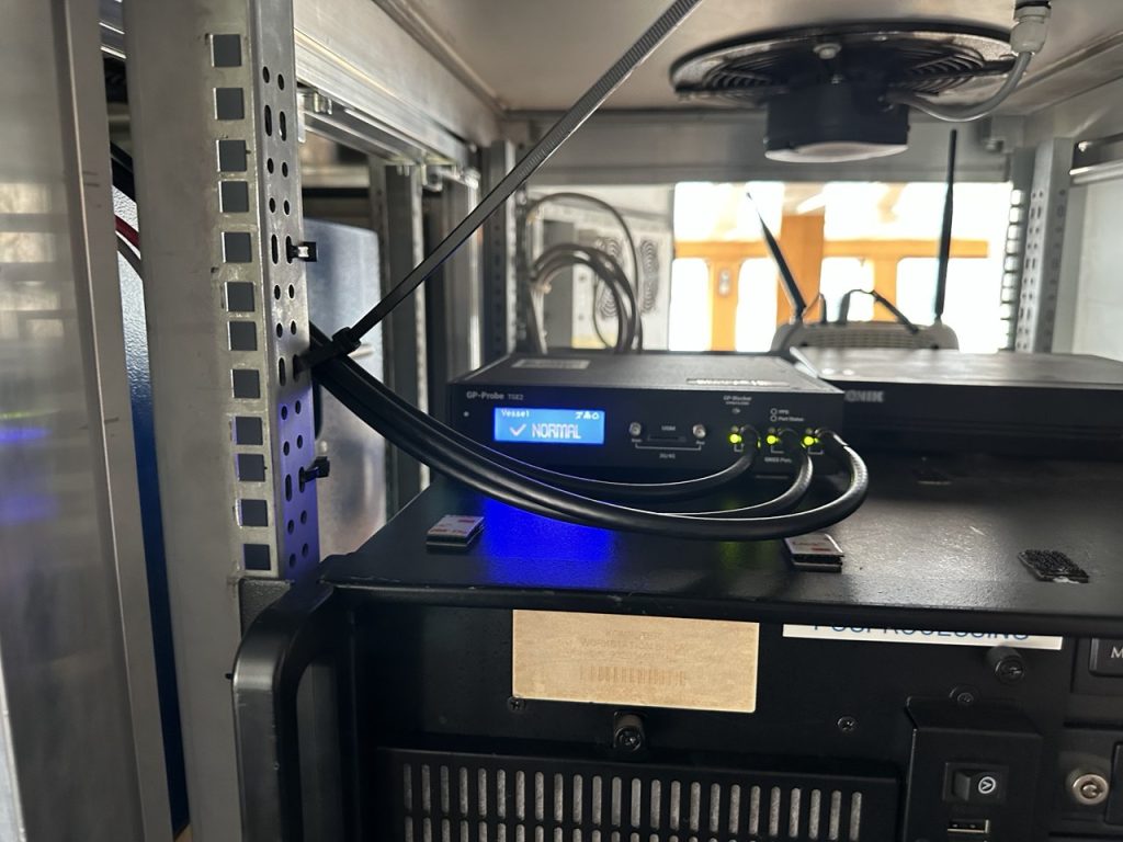
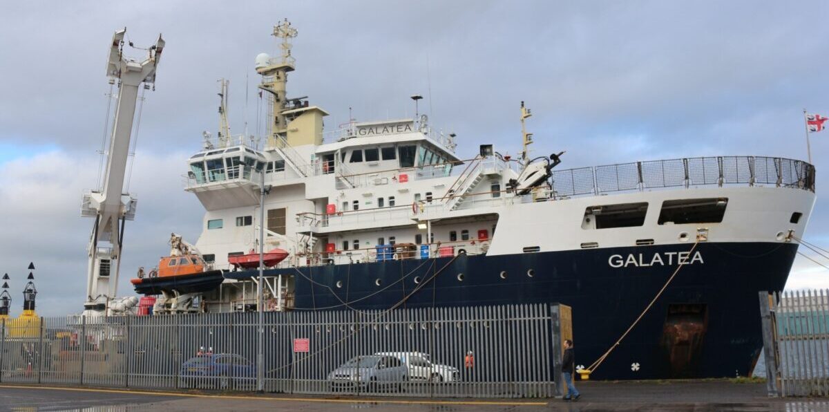
    CPI Electron Device Business – TMD Technologies Division has successfully completed sea trials of its cquantum-hybrid inertial navigation system (INS) aboard the THV Galatea, operated by Trinity House, the General Lighthouse Authority for England, Wales, the Channel Islands and Gibraltar.

    This milestone shows that quantum-enabled sensing hardware can operate stably in maritime conditions, with the potential to provide resilient positioning without continuous reliance on GNSS.

    Research indicates that a 24-hour GNSS outage could cost the UK economy £1.4 billion through cascading effects on logistics, transportation and critical infrastructure, underscoring the need for GNSS-independent solutions. By proving that quantum sensors can operate in operational conditions aboard a working vessel, CPI TMD is advancing technologies that reduce reliance on satellite navigation and improve resilience across maritime, defense and commercial sectors.

    The Harlequin System: Quantum-Enhanced INS

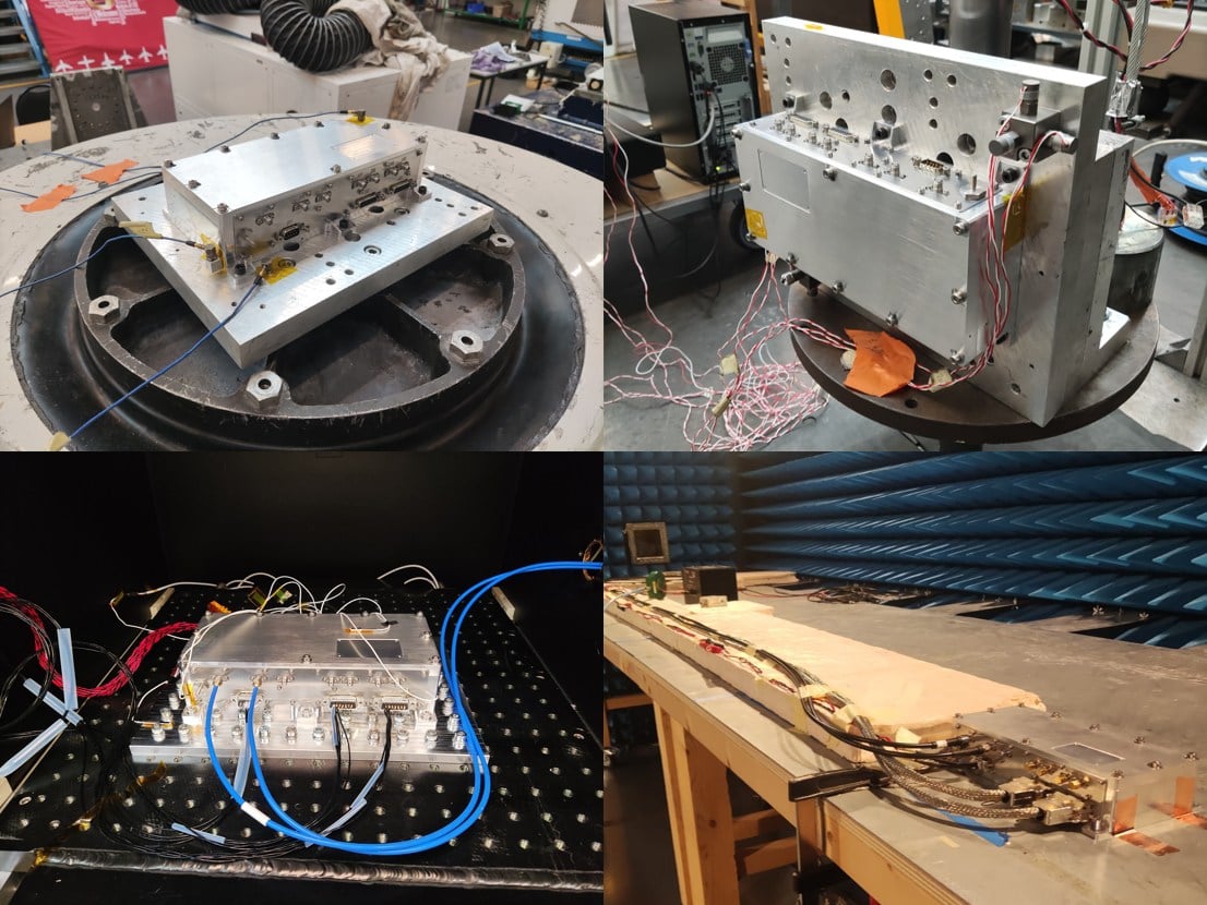
    The Harlequin system is a quantum-classical hybrid INS designed to extend GNSS holdover — the ability to maintain accurate position when satellite signals are unavailable or unreliable. Developed under an Innovate UK funded project, with partners from industry and academia, including the University of Strathclyde, and Joseph Cotter’s group at Imperial College London, Harlequin integrates classic INS components (a precise clock, a ring laser gyroscope, and a MEMS accelerometer) with CPI TMD’s gMOT-based quantum accelerometer.

    Onboard team for the sea trial. (Photo: CPI TMD)
    Onboard team for the sea trial. (Photo: CPI TMD)

    The gMOT cold atom source, developed by CPI TMD, the University of Strathclyde and Kelvin Nanotechnology, is a grating-based magneto-optical trap that provides a source of ultra-cold atoms that forms the basis of a portable, rugged quantum sensor.

    Conventional INS technology accumulates errors over time, causing position estimates to drift. By integrating its cold-atom accelerometer technology with classical INS technology, Harlequin leverages quantum-enhanced sensing to perform periodic drift corrections, extending the period over which a vessel can maintain accurate position in the absence of satellite-derived timing and positioning.

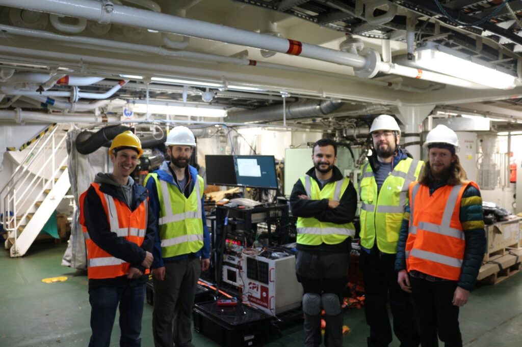
    Real-world trials: Operating around a working vessel

    The Harlequin trial demonstrates that quantum sensors can operate reliably outside the lab, functioning in the harsh conditions of real-world maritime operations—a crucial validation step toward field-deployable systems.

    The sea trial took place aboard the THV Galatea, which is not a scientific test vessel but an operational ship with a demanding day job: keeping shipping routes safe by ensuring buoys and lights are correctly placed and maintained, surveying the seabed for hazards, marking wrecks, and supporting marine-infrastructure projects such as cables and pipelines.

    The Harlequin system had to be loaded, tested and unloaded around the Galatea’s regular operational schedule, adding complexity to the trial and underscoring the system’s ability to integrate into real-world maritime workflows.

    Next Steps: System Upgrades and Second Trial

    Data gathered during the trial will inform a program of system upgrades aimed at improving performance and enhancing suitability for long-term shipboard operation. A second field trial is planned for the end of 2026 to validate improvements and bring it closer to operational readiness.

  • Positioning Australia expands capabilities with Ginan V4 release

    Positioning Australia expands capabilities with Ginan V4 release

    Geoscience Australia has released Ginan V4, the latest version of its home-grown, open-source toolkit for precise point positioning.

    Developed under the Positioning Australia program, Ginan V4 delivers world-class GNSS capabilities to innovators, researchers and industry professionals.

    Version 4 features a new intuitive graphical user interface (GUI) that makes data processing faster, easier and more accessible. The new GUI was designed to lower the barrier to entry for users across sectors. With simple data loading and streamlined output downloads, the new interface enables anyone — from navigation specialists to disaster response teams — to harness centimeter-level accuracy without needing advanced technical expertise.

    Ginan V4 also introduces enhanced robustness and improved software formatting, reducing errors and accelerating processing speeds. Users can expect smoother workflows and reliable results, whether calculating orbital mechanics or pinpointing precise locations on Earth’s surface.

    Ginan V4 remains fully modular, empowering users to build their own capabilities depending on their needs. From surveying and geospatial analysis to emergency response and scientific research, the toolkit supports innovation across diverse applications.

    Key benefits of Ginan V4

    • User-friendly interface. Simplifies data loading and output generation.
    • Enhanced robustness and speed. Fewer errors, faster processing.
    • Modular design. Customize capabilities for orbital mechanics, surveying or disaster response.
    • GNSS accuracy. Centimeter-level precision based on satellite observations.
    • Free and open source. Available to download via Geoscience Australia’s GitHub.

    As part of Positioning Australia’s suite of capabilities, Ginan V4 reflects Geoscience Australia’s commitment to delivering GNSS capabilities that support innovation, safety and productivity. By making the software free and open source, the program ensures that Australian expertise continues to drive global advances in positioning technology.

    Ginan V4 is available for free download on Geoscience Australia’s GitHub. More information can be found at ga.gov.au/positioning.

  • LEO satellites show promise in boosting navigation accuracy where GPS struggles

    LEO satellites show promise in boosting navigation accuracy where GPS struggles

    Low-Earth orbit (LEO) systems have emerged as a promising complement to GNSS, offering higher received power, better satellite geometry and broader spectrum options. Researchers aim to evaluate whether LEO-PNT can complement or enhance GNSS performance through large-scale simulations and design comparisons.

    Researchers from Tampere University and Universitat Autònoma de Barcelona published (DOI: 10.1186/s43020-025-00186-5) a comparative analysis in the December 2025 issue of Satellite Navigation. The study investigates how different LEO constellation configurations perform in positioning accuracy and interference robustness when operating alone or jointly with GNSS.

    Using semi-analytical modeling and 192,000 Monte Carlo simulations, the team evaluated 400 users across European regions in five outdoor scenarios. Key variables included carrier bands (1.5/5/10 GHz), effective isotropic radiated power (EIRP) levels and constellation geometry design.

    The team simulated multiple standalone and hybrid constellation architectures, analysing carrier-to-noise ratio (C/N0), geometric dilution of precision (GDOP), position dilution of precision (PDOP) and lower bound 3D accuracy.

    Results indicate that an EIRP of 50 dBm is sufficient for high-quality outdoor positioning when operating in L- and C-bands. While 10 GHz platforms require higher power to compensate for path loss, hybrid LEO + GNSS modes show markedly improved stability and reliability.

    Multi-shell constellations such as Çelikbilek-1 and Marchionne-2 delivered a favorable balance between satellite count and global geometry, outperforming single-shell layouts. In harsh urban canyon conditions, GNSS accuracy degraded up to seven-fold, whereas LEO-PNT maintained stable ranging performance with limited loss.

    Interference resistance also improved. Stronger LEO signal power means jammers require far greater intensity to cause equal degradation. Hybrid designs provided the most significant gains. Combinations such as Çelikbilek-1 + GPS/Galileo, or CentiSpace + BeiDou, yielded better PDOP distributions, faster fix availability and broader user coverage.

    The authors conclude that LEO systems are not aimed at replacing GNSS, but rather to enhance availability and resilience under signal-challenged environments.

    “Our results show that moderate-power LEO constellations can substantially strengthen outdoor positioning without requiring expensive satellite hardware,” the authors noted. “Geometry plays a major role — carefully designed multi-shell constellations achieve strong accuracy even with fewer satellites. As LEO-PNT develops, hybrid integration with GNSS offers the most cost-effective path toward secure, robust PNT solutions. This work provides guidance for future system designers evaluating frequency, transmission power and constellation configuration trade-offs.”

    The findings suggest a realistic rollout pathway for resilient satellite navigation. LEO-enhanced PNT could benefit autonomous vehicles, UAV routing, emergency response, precision farming and critical infrastructure monitoring — especially where GNSS falters in interference-dense or high-rise environments.

    Lower-power LEO transmission also reduces deployment cost, opening access for commercial operators.

    Future work may assess indoor positioning potential, bandwidth expansion, and real-orbit testing to refine simulation assumptions. As global demand for secure PNT grows, the integration of LEO and GNSS could become a cornerstone for next-generation navigation technology.

  • Galileo adds two new satellites

    Galileo adds two new satellites

    Europe has given fresh momentum to its Galileo navigation system following the successful Dec. 17 launch of two new satellites aboard an Ariane 6 rocket. The launch, the 14th of the program (L14), is one of the final three planned launches of first-generation (G1G) satellites. The two new satellites will strengthen the global positioning, navigation and timing services provided by the system.

    The launch comes at a critical moment for the constellation, which needs to replace its oldest satellites, stated GMV, lead developer and operator of the Galileo ground control segment.

    More than 4 billion users worldwide routinely rely on Galileo. This launch milestone ensures Europe’s ability to operate its own radionavigation system, which is essential for intelligent transportation, logistics, precision agriculture, defense, public safety, communications network operations, and energy generation and transmission.

    From centers in Oberpfaffenhofen, Germany, and Fucino, Italy, GMV manages post-separation operations from the launch vehicle and ensures the correct insertion of the new satellites into the constellation. GMV also operates 24/7 to monitor the health and position of each satellite, plan and execute orbital maneuvers, ensure signal integrity, and manage critical system operations.

    Coming soon: Second-Gen Galileo

    The L15 and L16 missions will complete the first generation of the system before transitioning to the second-generation Galileo satellites (G2G) under development. These will introduce advanced capabilities, greater accuracy, and enhanced resilience against interference and cyber threats, further strengthening Galileo’s role as a strategic infrastructure for Europe.

  • IATA sounds alarm over rising GNSS interference

    IATA sounds alarm over rising GNSS interference

    Collated from various news reports

    The International Air Transport Association (IATA) has called for vigilance following the increasing number of GNSS spoofing and jamming incidents worldwide. The growing interference poses a significant risk to flight navigation and pilot safety.

    Of note is a spike in incidents at major Indian airports. Almost 2,000 GNSS interference incidents have been logged at airports in India since 2023, including the airports in Delhi, Mumbai, Kolkata, Amritsar, Hyderabad, Bengaluru and Chennai.

    IATA represents more than 360 airlines, accounting for 80% of global air traffic. Indian carriers Air India, IndiGo, Air India Express and SpiceJet are members.

    “GPS spoofing and jamming incidents are increasing rapidly across the world,” said IATA Director General Willie Walsh, speaking at an industry event in Geneva. “This is not merely a technical concern — it’s an operational vigilance issue for pilots.”

    Walsh noted a higher frequency of interference events, expanding well beyond conflict zones and affecting global civil aviation routes.

    India’s Civil Aviation Ministry informed Parliament that between November 2023 and November 2025, a total of 1,951 GNSS interference cases were reported. The data collection began after the Directorate General of Civil Aviation (DGCA) issued an advisory circular in November 2023, mandating airlines to report all GNSS-related disruptions.

  • UK identifies issues in addressing PNT resilience

    UK identifies issues in addressing PNT resilience

    The United Kingdom has issued a summary of input it requested on positioning, navigation and timing (PNT) technologies. The UK deems PNT resilience critical for the UK’s economy.

    The 2023 Government Policy Framework for Greater PNT Resilience included an action to “develop a PNT growth policy, including R&D programmes, standards and testing, to drive innovation for PNT based productivity.”

    After a call for evidence, the UK Department for Science, Innovation & Technology received 128 responses from business, industry, academics and the public. These views on opportunities and challenges for the UK’s PNT industry are gathered in a document available online.

    Key themes identified

    • A viable market exists for GNSS-independent PNT, with respondents citing applications in defense and critical infrastructure.
    • Awareness of GNSS vulnerabilities in end users and critical infrastructure sectors is low.
    • Potential opportunities in GNSS-independent PNT and other technologies include eLoran, LEO-PNT, 5G, quantum PNT, inertial systems, and applications for GNSS-denied environments.
    • Short-term challenges include funding constraints and a lack of legislation and standards.
    • Long-term challenges include scalability, lack of sovereign manufacturing capability, and insufficient planning .
    • The industry is experiencing a skills shortage, especially in engineering, with a limited talent pipeline and lack of dedicated training opportunities.

    In all, 128 responses were received from businesses (sellers and users of PNT), academics, industry bodies and the public. Respondents could select multiple sectors when describing their background; the defense sector was selected most frequently (39 responses), followed by space (35 responses), aviation and drones (28 responses), maritime (28 responses) and communications (27 responses).

    Responses will be used, along with wider research, to inform future government policy interventions to support the UK PNT sector.

  • US Army seeks sources for GNSS-denied optical tracking

    US Army seeks sources for GNSS-denied optical tracking

    The U.S. Army is starting market research for possible sources of an optical tracking solution for its test ranges to use in GNSS-denied environments.

    The Army Contracting Command – Orlando issued a Sources Sought Notice Dec. 11 on behalf of the Test Resource Management Center Test and Evaluation/Science and Technology (T&E/S&T) Program.

    The Army wants to identify potential sources in the market having the interest, skills and ability to complete a thorough technology study and trade space analysis related to the viability of Time-Space-Position Optical Tracking (T-SPOT) for use on test ranges. The technology would be used as a time-space-position information (TSPI) truth sensor in GNSS-denied environments.

    Required capabilities

    The primary objective of a T-SPOT prototype effort would be to develop the system architecture, concept of operations, and comprehensive trade space analysis based on the results of modeling and simulation of the future-state system. The intent of the effort would not be to deliver the fieldable system itself but rather to answer whether/how such a system would achieve its performance goals.

    A future T-SPOT system should

    • achieve 3D TSPI accuracy comparable to the accuracy of real-time kinematic positioning (RTK) GNSS navigation systems.
    • be generated in a near-continuous manner, notionally at an update rate comparable to GNSS navigation systems.
    • achieve full performance during daylight and in good visibility conditions, with the goal of operating at day and at night and in all-weather conditions.
    • support temporary and modular integration with airborne systems being tested, operating at altitudes typical for the operation of U.S. Air Force cargo and single-engine training aircraft, with the goal of supporting aircraft closer to or on the ground. 
    • minimize its size, weight and power (SWaP) budget for integration with crewed aircraft, with the goal of supporting integration with small uncrewed aerial systems.

    In addition to the sensor hardware hosted on the SUT, a future T-SPOT system should rely on terrestrial features solely comprised of passive landmarks (no active emissions; no required power). The system may employ synthetic landmarks (e.g., purposely installed fiducials) and/or pre-existing landmarks (of either natural or human origin).  While the system must operate independently of GNSS, GNSS may be used pre- and post-test (i.e., for landmark surveying).

    More details are on the announcement page. The deadline for responses is Jan. 30.

  • NextNav to begin operating 5G-powered PNT network

    NextNav to begin operating 5G-powered PNT network

    The 5G PNT network in Santa Clara County will mark the first real-world demonstration of a 5G-powered backup to GPS

    NextNav Inc., a leader in next-generation terrestrial positioning, navigation, and timing (PNT) and 3D geolocation solutions, will commence operations of a 5G PNT network in Santa Clara County, California, as early as Dec. 11.

    Network operations of positioning, navigation and timing applications represent the next milestone toward commercial readiness and the mission to deliver a resilient complement to GPS.

    The 5G PNT network will consist of multiple fixed base station locations using a standards-compliant 5G signal with a positioning reference signal (PRS) enabled, a standalone 5G core, and NextNav’s 3D PNT architecture. The network’s authorized technical parameters will align with those in NextNav’s proposal to optimize the lower 900 MHz band to enable a terrestrial, widescale backup to GPS that is broadly available to critical infrastructure, public safety and American consumers.

    “We’re incredibly pleased to continue demonstrating our technology in a real-world operational environment,” said Mariam Sorond, CEO of NextNav. “Activating this network is a critical step in our commercialization process, proving that robust 5G broadband service and high-integrity PNT can be delivered together, at scale, using standard 5G equipment.”

    The 5G PNT network will validate NextNav’s 5G PRS-based PNT end-to-end architecture under real-world conditions.

    “This is the first public demonstration of a full-scale and operational 5G-based PNT in live deployment, delivering both resilient PNT and broadband service simultaneously,” said Arun Raghupathy, NextNav Co-Founder and CTO. “Through this commercialization deployment, we’re validating our 5G-based network can deliver accurate 3D location, improved timing synchronization, and enhanced resilience. This real-world deployment is critical to establishing U.S. leadership in next-generation PNT technologies.”

    The 5G PNT network will support the broader adoption of 5G-based terrestrial PNT with 5G broadband capabilities for operators, enterprises and ecosystem partners. This deployment will also prove that NextNav’s software solution is ready to scale and deliver commercial PNT while serving the critical national security and public safety needs of the United States.

  • Moldova’s positioning system now uses Galileo

    Moldova’s positioning system now uses Galileo

    The MOLDPOS National Positioning System in Moldova has been integrated into the European Position Determination System (EUPOS),  a pan-European GNSS augmentation service.

    The MOLDPOS navigational system uses both GPS and GLONASS, and now Galileo has been added, according to Anatol Ghilas, director of the Agency of Land Relations and Cadastre (ALRC) of Moldova. Ghilas said the question of integration with the European system of Galileo was often discussed, and is a step forward in promoting the positioning technology.

    Creation of MOLDPOS was gradual. First, sites for placement of MOLDPOS stations were selected, then the stations were installed. Once installations were in place, the system was tested and launched. Now it is integrated into EUPOS.

    Moldova had been a member of the European Position Determination System since 2008.

    According to Norwegian Ambassador to Moldova Øystein Hovdkinn, Moldova and Norway are situated in opposite parts of Europe, but it did not impede establishing friendly relations. Norway provided financial aid to build MOLDPOS.

    Hovdkinn said that the Government of Norway supports the program of reforms in Moldova. The project’s goal is to promote Moldova’s development as a modern country and to promote its integration in Europe.

    According to Gheorghe Duca, president of the Moldovan Academy of Sciences, implementation of MOLDPOS will have a positive influence upon the country’s social, economic and scientific sectors.

    “A digital map is necessary for preventing floods, for rehabilitating roads, in agriculture and in science,” Duca said, adding that Moldova is the first country on the border with the European Union that will have digital maps, expected to be available in 10 months.

  • New GNSS interference report released

    New GNSS interference report released

    Shipborne Measurements Near the Kaliningrad Border

    A major new report by GPSPATRON gathered data between June 23 and Oct. 14, aboard a vessel routinely leaving the Port of Gdańsk and performing extended maneuvers in open water.

    The vessel conducted multiple offshore measurement campaigns, resulting in a shipborne dataset that provides a far more accurate representation of the true GNSS environment experienced by maritime operators in the Gulf of Gdańsk. It also reveals a level of interference complexity and intensity not visible in a previous coastal study.

    In that previous six-month investigation, conducted from a fixed sensor installed at the Gdynia Maritime University campus, the authors documented persistent multi-constellation jamming, as well as indications of mobile maritime interference sources operating in the region. Read the earlier report here: Report on GNSS Interference in the Baltic Sea: Analysis Using a Terrestrial Monitoring System and Comparison with ADS-B Data

    In the present phase of research, the GPSPatron team moved beyond land-based monitoring and installed itsGP-Probe TGE2 interference sensor directly on board a research vessel. The ship operated throughout the southern Baltic Sea, including regular approaches toward the maritime boundary of the Kaliningrad region.

    By placing the sensor on a moving platform rather than a coastal location, they were able to record GNSS interference exactly as it affects real vessels — capturing signal conditions that cannot be observed from shore due to differences in radio horizon, antenna orientation, multipath environment, and proximity to potential interference sources.

    The GPSPATRON probe TGE2 instaslled within the vessel's equipment. (Photo: GPSPATRON)
    The GPSPATRON probe TGE2 instaslled within the vessel’s equipment. (Photo: GPSPATRON)

    Transition from classical jamming to combined spoofing-jamming interference

    In contrast to the previous six-month coastal study, where all recorded GNSS interference consisted exclusively of multi-constellation jamming, the current shipborne campaign reveals a fundamentally different interference landscape.

    All major events now present a dual-layer structure composed of:

    • GPS L1 spoofing, generating forged satellite-like signals, and
    • Simultaneous jamming of GLONASS, Galileo, and BeiDou.

    This combined architecture forces GNSS receivers to rely solely on spoofed GPS signals while denying access to independent ranging sources. The practice is consistent with commonly used operational strategies: spoofing only one constellation (GPS) drastically reduces system complexity and cost, whereas spoofing all GNSS systems would require multiple parallel RF chains, SDR-based generators, algorithms for signal simulations and amplifiers.

    Highest recorded levels of GNSS disruption

    The most severe interference period occurred from late June through July, during which:

    • GNSS availability dropped to 83.5%,
    • 4 days, 5 hours and 24 minutes of spoofing were recorded — by far the highest cumulative spoofing activity of the entire campaign.

    The single most extreme incident took place between 1 and 3 July, with nearly 30 consecutive hours of spoofing within a 48-hour interval, posing a severe risk for maritime navigation.

    In subsequent months the interference intensity gradually decreased, yet low-power and short-duration events continued to be observed.

    The area of the Baltic Sea the vessel patroled for GNSS interference. (Image: GPSPATRON)
    The area of the Baltic Sea the vessel patroled for GNSS interference. (Image: GPSPATRON)

    A multi-emitter, synchronously operating interference network

    Spectrogram analysis reveals that the interference does not originate from a single source but from four distinct, technologically different emitters operating in coordination:

    • GPS spoofing transmitter generating forged L1 signals.
    • Lower-band chirp jammer suppressing GPS, Galileo, and BeiDou.
    • Upper-band chirp jammer suppressing GLONASS G1 only.
    • Full-band analog-like broadband jammer covering the entire 60 MHz GNSS L1 band.

    The synchronous activation and termination of all four components indicate a centrally coordinated system, yet their differing spectral signatures, bandwidths, and stability levels confirm multiple spatially separated stations rather than a single unified installation.

    This GNSS interference analysis shows interference intensity increases away from port. (Image: GPSPATRON)
    This GNSS interference analysis shows interference intensity increases away from port. (Image: GPSPATRON)

    Evolution of interference modulation techniques

    A clear shift is observed compared to the previous study :

    • Previously, the dominant interference source consisted of a high-quality, purpose-engineered wideband signal with three clean constellation-matched components — an indication of modern, precisely designed jamming equipment.
    • In the current campaign, the prevailing interference is simpler wideband chirp jamming, a less advanced technique but deployed at significantly higher power levels.
    • The wideband analog-like component further shows pronounced parasitic frequency fluctuations, characteristic of older low-stability RF hardware.

    This indicates a shift from high-precision jamming to a mixed environment of legacy high-power systems combined with newer spoofing capabilities.

    Interference strongly intensifies offshore

    A distinct spatial gradient was recorded:

    • In the Port of Gdańsk, interference appears weak or barely detectable.
    • As the vessel moves into open water, the same signals become up to 15 dB stronger.
    • The interference power consistently increases when approaching the waters facing Kaliningrad.

    This pattern shows that — intentionally or not — the interference system affects maritime traffic far more than coastal infrastructure, with the operational impact being greatest in offshore navigational zones.

    Download the full report using the form on this page.

  • Opinion: The truth about NextNav’s 5G-powered 3D PNT

    Opinion: The truth about NextNav’s 5G-powered 3D PNT

    On Nov. 11, the chair of the Z-Wave Alliance, Avi Rosenthal, published an opinion piece in GPS World, urging a delay in addressing one of America’s most pressing national security and economic vulnerabilities. I am talking about the need for a terrestrial complement to GPS. By ignoring both the urgency of the threat and the strength of the engineering analysis supporting near-term solutions like 5G-powered 3D PNT, Mr. Rosenthal argues the U.S. can afford to wait. At NextNav, we strongly disagree.

    Around the world, GPS disruptions are no longer hypothetical. As this publication has documented, incidents of GPS jamming and spoofing have become routine in places like the Middle East and the Baltic states. And the increasing severity of these disruptions is spilling over into civilian life, putting us all at risk. We’ve seen the consequences here at home, too. Major airports have experienced manmade GPS disruptions of unknown origin, and farmers have seen how even temporary GPS loss can upend precision agriculture.

    Whether caused by jamming, spoofing or natural disasters, the vulnerabilities are real and growing.

    These threats are why the Federal Communications Commission (FCC) made it a priority to advance additional technologies and solutions as part of a whole-of-government approach to strengthen PNT resiliency. At NextNav, we are doing the hard work necessary to help enable a system-of-systems capable of delivering greater PNT resilience into America’s critical infrastructure, while Mr. Rosenthal and his allies continue to rely on flawed studies and broad mischaracterizations of our proposal. They preach delay rather than moving to the logical next step of the FCC process, specifically designed to allow the commission to fully evaluate competing technical claims.

    We have filed multiple comprehensive engineering studies demonstrating that 5G operations in the lower 900 MHz band will not cause unacceptable interference to unlicensed devices. Those studies specifically examined five different unlicensed technologies, including the Z-Wave technology. To ensure this discussion is fact-based, we’d like to set the record straight.

    The SIA-sponsored paper that Mr. Rosenthal cited for his unrealistic claims of interference does not hold up under scrutiny and contains a number of fundamental technical errors. As we’ve outlined in detail, NextNav’s detailed technical analysis has identified significant flaws in the Pericle paper, pointing out fundamental errors in the paper’s assumptions and methodology.

    For instance, Pericle’s predicted 5G emission levels exceed levels found in theoretical free-space conditions — an impossibility that undermines the entire paper. The Pericle paper also seems to ignore how 5G positioning signals work, failing to mention comb patterns and muting that are core to the technology, and thereby further inflating perceived 5G emission levels. Attempts to reproduce Pericle’s simulations with Pericle’s stated methods and parameters yield dramatically different results, which serve as clear evidence of computational errors or faulty execution of the depicted scenario.

    Perhaps most remarkably, no credible analysis could replicate Pericle’s conclusion that 5G interference would occur more than 50 percent of the time when the ostensibly interfering transmitter operates only 50 percent of the time.

    The most glaring issue with the paper that Rosenthal cites is that it never directly analyzes the very devices that the security industry states are predominant in home and business security systems today. Specifically, it fails to analyze Z-Wave, the technology that, according to the Z-Wave Alliance, is utilized by more than 90% of professionally monitored security systems in North America. In fact, Z-Wave operates primarily on frequencies that are outside of the frequencies which NextNav’s proposes to use for 5G.

    It is a fact that unlicensed lower 900 MHz devices today successfully coexist with a wide range of unlicensed users that operate without coordination or interference protection. Pericle never accounts for the resilience mechanisms Part 15 devices use every day, including frequency hopping, bursty transmissions, adaptive modulation, redundant paths (meshing), self-healing and other features.

    Lastly, Mr. Rosenthal’s characterization of the Department of Transportation’s action also fails to mention that the DOT has already evaluated NextNav’s technology, ranking NextNav first in every category of its 2021 evaluation. In 2024, DOT awarded NextNav the largest grant, $1.8M, for Rapid Phase I field testing of PNT technologies. NextNav supports DOT’s ongoing work to advance complements to GPS, but its testing should not stand in the way of swiftly advancing solutions that are ripe for action now.

    Waiting for DOT to conclude its testing of multiple additional PNT technologies before the commission acts within its authority to take the next step towards enabling one or more potential solutions not only runs contrary to a Presidential Executive Order for agencies to remove barriers to private sector investment, but also risks the same analysis paralysis that slowed deployment of resilient PNT in the previous administration.

    At NextNav, we are serious about solving an urgent national security problem, and we will continue to do the hard work necessary to support the FCC’s engineering-driven decision making. The FCC is the expert authority on commercial spectrum issues, and we believe it has all of the information it needs to take the next step in this process by issuing a Notice of Proposed Rulemaking (NPRM). Issuing an NPRM would also give the FCC the opportunity to ask any remaining technical or economic questions that it may deem necessary to complete its evaluation.

    It’s time to roll up our sleeves and do the hard work necessary to enable a system-of-systems approach to building great PNT resilience. The longer we delay, the more vulnerable we become.

    Renee Gregory is the vice president of regulatory affairs at NextNav.

  • SpacePNT completes qualification testing for second-gen spaceborne GNSS receiver

    SpacePNT completes qualification testing for second-gen spaceborne GNSS receiver

    SpacePNT SA, a global provider of high-accuracy, radiation-tolerant spaceborne GNSS receiver equipment for missions ranging from Earth to cislunar orbit, has completed extensive qualification testing of its second-generation product, including vibration, shock, thermal vacuum and electromagnetic compatibility tests.

    The multi-frequency, multi-GNSS receiver resulted from two European Space Agency (ESA) ARTES Competitive & Growth (C&G) development projects supported by ESA and the Swiss Space Office.

    The first project enabled SpacePNT to develop an industrialized second-generation product for large-scale production targeting low-Earth orbit, LEO position-navigation-timing and geostationary orbit telecommunications constellations. The receiver includes a proprietary Precise Orbit Determination algorithm that provides sub-decimeter real-time positioning and timing aboard spacecraft. The company validated the POD algorithm in a hardware-in-the-loop environment and retrofitted it into two first-generation flight models delivered to a customer for satellite integration.

    Under the second project, SpacePNT developed a Radiation Hardiness Assurance approach for long-duration missions in harsh radiation environments. ESA’s GENESIS satellite mission, which will operate in a challenging medium Earth orbit environment, will be the first to use this RHA approach. SpacePNT will supply the mission’s GNSS receiver equipment.

    Though the second-generation receiver uses largely the same hardware, software and firmware technology as the company’s flight-proven first-generation product, SpacePNT performed a complete qualification campaign to validate design changes.

    After passing all qualification and performance tests, SpacePNT will begin manufacturing first flight models of its second-generation products for several customers. The receivers will fly on demanding Earth observation, in-orbit servicing and space exploration missions at altitudes from LEO through medium Earth orbit, geosynchronous transfer orbit, geostationary orbit and lunar distances.

    The views expressed herein do not reflect the official opinion of the European Space Agency.