Depending on your age, 30 years represents a varying opinion of time. For some, it may seem like forever; for others, it may be a blink of an eye. In respect to technology, it can represent a complete change in the way we do things.
When we turned the calendar page to January 1990, our world had yet to experience the internet, the Hubble telescope had not been deployed to share its fantastic views, and The Simpsons television series was preparing to become the cartoon juggernaut it remains today.
Yes, lots has changed since 1990, and surveying is no exception.
Most professions look back through their history and see various periods where discoveries and inventions revolutionized how the work was completed.
For surveyors, the past 30 years have contained more advancements than all other years combined, with the greatest achievement being the global navigation satellite system (GNSS). With the United States leading the way with its Global Positioning System and the civilian ability to use this measuring system, modern surveying was forever changed.
Solar and lunar observations replaced
Before the implementation of a satellite navigation system, true global navigation was only computed using solar and lunar readings under specific conditions. GPS provided a new frontier for surveyors to establish positions without having to perform traversing from known points or collecting solar/lunar observations.
As the constellation grew, it became easier to use GPS to gain initialization for accurate and redundant position determination. As processor speeds and data storage capability increased, real-time kinematic (RTK) observations became the norm for surveyors everywhere.
The Russian satellite constellation, GLONASS, began operating fully in the late 1990s, and is now included to create today’s GNSS. More satellites provide more coverage, which in turn means more data collection potential.
Many nations and regions are building their own constellations to augment the current GNSS lineup, and also to safeguard the ability to obtain geographic locations when other systems are not available.
Bathymetric surveys made easy
GNSS capability and integration revolutionized several aspects of surveying, including a new and more reliable way of performing bathymetric surveys over large bodies of water. Computerized depth sounders were programmed to coincide readings with GNSS data collection to provide a more accurate and precise method of hydrographic surveying.
The past decade has continued the reliance on GNSS technology with many more devices and applications — not just for the surveyor, but for the public as well. While surveyors are using GNSS receivers on unmanned vehicles such as UAVs and boats, satellite navigation has infiltrated into many of our everyday routines. Cellphones, fitness trackers and our automobiles use this technology to guide us to our destinations.
Surveyors have used the GNSS revolution to create a digital world for better data collection, asset management and increased efficiency. Much has changed in 30 years for the surveyor and the world around us, so we should not be surprised about what technology will bring us next.
GPS had been around for about five years before first launch in February 1978 and Full Operational Capability (FOC) was eventually declared in April 1995. It takes time to develop, field and prove something as complex as the world’s first satellite navigation system. But we’re now well into a third generation of the venerable GPS, with GLONASS, Galileo, BeiDou and IRNSS/NavIC and QZSS around the world and in geographic locales. So, putting aside Transit or anything else, this would make GPS about 47 years old — heading into middle age.
Therefore, it would seem that Glen Gibbons waited until “this GPS thingy” looked like it might actually work — circa 1990 — to launch GPS World, since the magazine is now 30 years old and is also into its third-generation of editor-custodians! Alan Cameron bravely carried the flag after Glen and nurtured the magazine for a good number of years and brought me into the fold as a contributor. We shared ION GNSS conventions and GPS World Leadership dinners and he was able to cajole monthly articles out of me for many years. Now Marty Whitford has his hand firmly on the tiller as publisher, with Tracy Cozzens as senior editor.
So what went down during these decades of technological advancement and for many of the people in the satnav industry? It would be impossible to answer within my word-limit, so I’ll take on an extremely small subset and recount a few things I can still remember.
µGPS. I got into GPS around 1990 in an OEM board-level product spin-off program from a certified GPS airborne receiver at CMC in Montreal — we initally called that L1 receiver µGPS because then it was a small GPS board. Later it became known as the AllStar receiver. We found pretty neat applications for the early ’90s — golf-course systems, vehicle tracking, airport vehicle tracking, the start of vehicle nav systems and such.
At NovAtel in Calgary in the early ’90s, we watched things develop through L1/L2 dual frequency, began RTK market applications in survey, geographic information systems (GIS), agriculture, mining and all multitudes of attempts to get new companies off the ground.
WAAS. Eventually the U.S. Wide-Area Augmentation System (WAAS) program came and swallowed us up through three different prime contractors. Once that Federal Aviation Administration program was running well, we were into programs in Europe, Japan, India and China, and that led into Galileo ground reference receivers. The software qualification work we did on Galileo positioned us to take on mil-spec receiver work, and even anti-jam products.
Then CMC bought NovAtel, and we also joined with CMC to develop a certified airborne receiver. In 2003, NovAtel bought the AllStar OEM product line from CMC — funny how things work out! The joint certified receiver program eventually resulted in a new generation of high-accuracy airborne sensors. We again changed hands in 2007 when Hexagon bought us, and then NovAtel began working closely with Hexagon subsidiary Leica on survey applications. Many new and interesting developments are still going on there.
Nowadays, my interests lie with assisted GNSS and with Rx Networks in Vancouver, which I support and advise. Assisted GNSS comes in many forms, has many avenues in the marketplace, and presents its own unique challenges.
As GPS has evolved into GNSS and into so many, many applications, companies have come and gone but the core of people who drive the industry has grown and acquired new and specialized skills, developing ever more capable technology and products. Even after 47 years of the industry and 30 years of GPS World, we aren’t anywhere close to done.
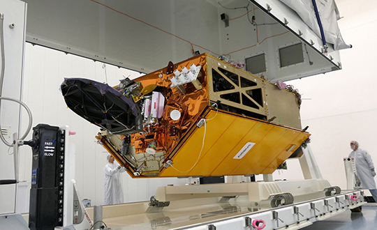
To get the best measurements of Earth’s atmosphere, you sometimes have to leave it. This November, the Sentinel-6 Michael Freilich spacecraft will do just that.
News from the Jet Propulsion Laboratory
When a satellite by the name of Sentinel-6 Michael Freilich launches this November, its primary focus will be to monitor sea-level rise with extreme precision. But an instrument aboard the spacecraft will also provide atmospheric data that will improve weather forecasts, track hurricanes and bolster climate models.
“Our fundamental goal with Sentinel-6 is to measure the oceans, but the more value we can add, the better,” said Josh Willis, the mission’s project scientist at NASA’s Jet Propulsion Laboratory in Southern California. “It’s not every day that we get to launch a satellite, so collecting more useful data about our oceans and atmosphere is a bonus.”
A U.S.-European collaboration, Sentinel-6 Michael Freilich is one of two satellites that compose the Copernicus Sentinel-6/Jason-CS (Continuity of Service) mission. The satellite’s twin, Sentinel-6B, will launch in 2025 to take over for its predecessor. Together, the spacecraft will join TOPEX/Poseidon and the Jason series of satellites, which have been gathering precise sea-level measurements for nearly three decades. Once in orbit, each Sentinel-6 satellite will collect sea-level measurements down to the centimeter for 90% of the world’s oceans.
JPL-developed instrument
Meanwhile, they’ll also peer deep into Earth’s atmosphere with GNSS-RO to collect highly accurate global temperature and humidity information. Developed by JPL, the spacecraft’s GNSS-RO instrument tracks radio signals from navigation satellites to measure the physical properties of Earth’s atmosphere. As a radio signal passes through the atmosphere, it slows, its frequency changes, and its path bends. Called refraction, this effect can be used by scientists to measure minute changes in atmospheric physical properties, such as density, temperature, and moisture content.
The precise global atmospheric measurements made by Sentinel-6 Michael Freilich will complement atmospheric observations by other GNSS-RO instruments already in space. Specifically, the National Oceanic and Atmospheric Administration’s National Weather Service meteorologists will use insights from Sentinel 6’s GNSS-RO to improve weather forecasts.
Also, the GNSS-RO information will provide long-term data that can be used both to monitor how our atmosphere is changing and to refine models used for making projections of future climate. Data from this mission will help track the formation of hurricanes and support models to predict the direction storms may travel. The more data we gather about hurricane formation (and where a storm might make landfall), the better in terms of helping local efforts to mitigate damage and support evacuation plans.
The Sentinel-6 Michael Freilich spacecraft undergoes tests at its manufacturer Airbus in Friedrichshafen, Germany, in 2019. The white GNSS-RO instrument can be seen attached to the upper left portion of the front of the spacecraft. (Photo: Airbus)
A brief history of radio occultation
Radio occultation was first used by NASA’s Mariner 4 mission in 1965 when the spacecraft flew past Mars. As it passed behind the Red Planet from our perspective, scientists on Earth detected slight delays in its radio transmissions as they traveled through atmospheric gases. By measuring these radio signal delays, they were able to gain the first measurements of the Martian atmosphere and discover just how thin it was compared to Earth’s.
By the 1980s, scientists had started to measure the slight delays in radio signals from Earth-orbiting navigation satellites to better understand our planet’s atmosphere. Since then, many radio occultation instruments have been launched; Sentinel-6 Michael Freilich will join the six COSMIC-2 satellites as the most advanced GNSS-RO instruments among them.
“The Sentinel-6 instrument is essentially the same as COSMIC-2’s. Compared to other radio occultation instruments, they have higher measurement precision and greater atmospheric penetration depth,” said Chi Ao, the instrument scientist for GNSS-RO at JPL.
GNSS-RO basics
The GNSS-RO instrument’s receivers track navigation satellite radio signals as they dip below, or rise from, the horizon. They can detect these signals through the vertical extent of the atmosphere — through thick clouds — from the very top and almost all the way to the ground. This is important, because weather phenomena emerge from all layers of the atmosphere, not just from near Earth’s surface where we experience their effects.
“Tiny changes in the radio signal can be measured by the instrument, which relate to the density of the atmosphere,” said Ao. “We can then precisely determine the temperature, pressure, and humidity through the layers of the atmosphere, which give us incredible insights to our planet’s dynamic climate and weather.”
With the help of JPL’s GNSS-RO principal investigator Chi Ao and NOAA’s National Weather Service meteorologist Mark Jackson, this video explains how the GNSS-RO instrument aboard Sentinel-6 Michael Freilich will be used by meteorologists to improve weather forecasting predictions. (Credit: NASA/JPL-Caltech)
But there’s another reason why probing the entire vertical profile of the atmosphere from orbit is so important: accuracy. Meteorologists typically gather information from a variety of sources – from weather balloons to instruments aboard aircraft. But sometimes scientists need to compensate for biases in the data. For example, air temperature readings from a thermometer on an airplane can be skewed by heat radiating from parts of the aircraft.
GNSS-RO data is different. The instrument collects navigation satellite signals at the top of the atmosphere, in what is close to a vacuum. Although there are sources of error in every scientific measurement, at that altitude, there’s no refraction of the signal, which means there’s an almost bias-free baseline to which atmospheric measurements can be compared in order to minimize noise in data collection.
And as one of the most advanced GNSS radio occultation instruments in orbit, said Ao, it will also be one of the most accurate atmospheric thermometers in space.
More on the mission
Copernicus Sentinel-6/Jason-CS is being jointly developed by the European Space Agency (ESA), the European Organisation for the Exploitation of Meteorological Satellites (EUMETSAT), NASA, and the National Oceanic and Atmospheric Administration (NOAA), with funding support from the European Commission and support from France’s National Centre for Space Studies (CNES).
The first Sentinel-6/Jason-CS satellite that will launch was named after the former director of NASA’s Earth Science Division, Michael Freilich. It will follow the most recent U.S.-European sea-level observation satellite, Jason-3, which launched in 2016 and is currently providing data.
NASA’s contributions to the Sentinel-6/Jason-CS mission are three science instruments for each of the two Sentinel-6 satellites: the Advanced Microwave Radiometer, the GNSS-RO, and the Laser Retroreflector Array. NASA is also contributing launch services, ground systems supporting operation of the NASA science instruments, the science data processors for two of these instruments, and support for the international Ocean Surface Topography Science Team.
The 2020 GPS Public Interface Control Working Group Meeting will take place on Sept. 30, announced the U.S. Air Force Space and Missile Systems Center. The meeting includes an open forum to update the public on GPS public document revisions.
The meeting will collect issues and comments for analysis and possible integration into future GPS public document revisions.
The meeting is scheduled from 8:30 a.m. to 4 p.m. (Pacific Standard Time). Portfolio Architect Corp. will host the meeting, which is open to the general public.
Attendees are highly encouraged to participate virtually. The meeting facility in-person capacity may be reduced based on government restrictions; in-person attendees should plan accordingly. Attendees are also expected to comply with COVID–19 health precautions, such as maintaining social distance and wearing a facemask.
Documents Affected
IS-GPS-200: Navigation User Interfaces
IS-GPS-705: User Segment L5 Interfaces
IS-GPS-800: User Segment L1C Interface
ICD–GPS–240 (NAVSTAR GPS Control Segment to User Support Community Interfaces).
Meeting Address:
Coronado Conference Room (17th Floor)
SAIC
200 N Pacific Coast Highway
El Segundo, CA 90245
The European GNSS Agency (GSA), in collaboration with the Council of European Geodetic Surveyors (CLGE), has launched the Geomatics on the Move 2020 competition. The event aims to foster the use of European Union (EU) satellite programs Galileo, EGNOS and Copernicus among students, young professionals, entrepreneurs and small and mid-sized businesses to create innovative geomatics applications and solutions across all over Europe.
Building and expanding on the CLGE Student Contest, which has been held for the past nine years, the new Geomatics on the Move Prize Contest targets applications that integrate the use of additional technologies such as artificial intelligence, machine learning, augmented and virtual reality, as well as supplementary remote sensing data sources like drones, GSA said. Solutions animated through mobile phone applications or other easy-to-use platforms are also accepted.
“This is the ninth year of partnership between the Council of European Geodetic Surveyors and the GSA; over the years we have seen some exciting and innovative solutions emerge that leverage the EU Space Programme to deliver practical solutions for the mapping and surveying community,” said GSA Acting Executive Director Pascal Claudel. “This year, as we recover from this global setback, I look forward to seeing even more novel ideas — from all over the European Union — able to respond to current and future challenges.”
The competition will be organized in two stages. The first phase is an open call for ideas, during which applicants submit posters describing their ideas. The deadline for these submissions is Oct. 16.
The proposals then will be evaluated by the GSA and CLGE, and a maximum of 10 projects will be chosen to present their pitch during the finals. The selected applicants will refine their poster and prepare their pitch, for which technical support and training will be made available.
The official award of the Geomatics on the Move prize contest will take place virtually, during the European Space Week, taking place Dec. 7-11. During this event, finalists will present their solutions to the evaluation board, and winners will be announced on the official contest site.
With an overall prize of €30 000, a set of 10 prizes will be offered in two categories. The first of these categories targets EU space-based traditional geomatics solutions and the second targets integrated geomatics solutions. he first category is looking for solutions in which the main innovation is based on the use of EGNSS, employing traditional equipment such as surveying or GIS grade GNSS receivers for applications such as cadastral, marine and mining surveying or GIS mapping. The integrated geomatics category targets integrated surveying solutions that use Galileo or EGNOS and leverage cutting-edge tools and technologies such as drones, mobile mapping, laser scanners or augmented/,mixed reality, both within geomatics applications or beyond.
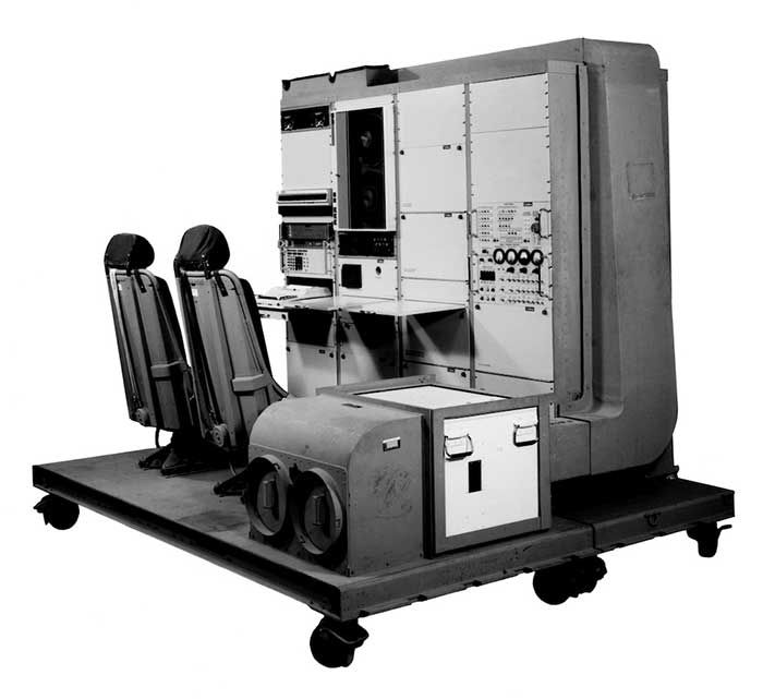
1976: The first military GPS five-channel receiver built in one of several programs that studied the feasibility of GPS. The receiver weighed more than 270 pounds and had seats for two operators. (Photo: Rockwell Collins/Smithsonian)
Like the internet before it, GPS started as a niche technology and became a universally recognized one, though much misunderstood and often taken for granted. Both systems originated in the U.S. Department of Defense (DOD) to support military missions, and then exploded into mass-market civilian technologies. While the internet passed from military to civilian hands very early in its history, GPS is still operated by the U.S. Air Force, making it a unique experience for the DOD: a system for which it is responsible that has orders of magnitude more civilian applications and users than military ones.
GPS has transformed entire professions — most notably, surveying; created new industries — such as ride sharing; boosted innumerable fields of scientific research — from archaeology to zoology; facilitated many aspects of everyday life — such as finding retail outlets and getting there; and given an advantage to U.S. military forces. One application discussed 30 years ago that has not yet lived up to its promised return on investment is precision agriculture.
Challenges and debates that loomed large in the early days turned out to be growing pains —most notably, Selective Availability (SA). In 1990, Javad Ashjaee reflected the attitude of much of the GPS industry and user community when he said, “I can’t think of a word to say how bad it is.” Other debates have proven more persistent — such as the interference threat posed by LightSquared, reborn after bankruptcy as Ligado Networks.
GPS first drew considerable publicity in the wake of Desert Storm, when it became the subject of television features, newspaper reports, and special sections in the pages of recreational catalogs. “Ironically,” Brad Parkinson pointed out in September 1994 in GPS World, “civil companies [such as Garmin] developed most receivers used in Desert Storm, with no help from military sponsorship.” Later that decade, while most people were finally aware of GPS technology, it began disappearing deep into its applications and the systems that use it.
In September 1991 — three and a half years before U.S. Air Force Space Command declared the system’s full operational capability (FOC) on April 27, 1995 — in a speech to the International Civil Aviation Organization in Montreal former FAA Administrator James B. Busey said: “I want to emphasize that we fully support the eventual replacement of [GPS] by other systems — and we are certain that will happen.” That may still happen, in the distant future. However, what Busey did not foresee is that GPS became but an element, though a key one, in a much larger positioning, navigation and timing (PNT) system. This worldwide system includes three other GNSS and two regional ones, several publicly and privately operated augmentation services, and a wide range of complementary and alternative technologies. These include inertial navigation (which has advanced much in the past three decades) and RF signals of opportunity. It may soon include navigation signals from non-GNSS satellites, eLoran, enhanced distance measuring equipment, and Earth-fixed navigation using very low frequency.
I began my current career in geospatial technologies exactly 20 years ago, as this magazine’s managing editor, just a few months after the end of SA increased GPS’ accuracy by an order of magnitude, and equally expanded the number of its potential applications. Yet today, I still marvel at how pervasive this technology has become and how much further it will transform our lives.
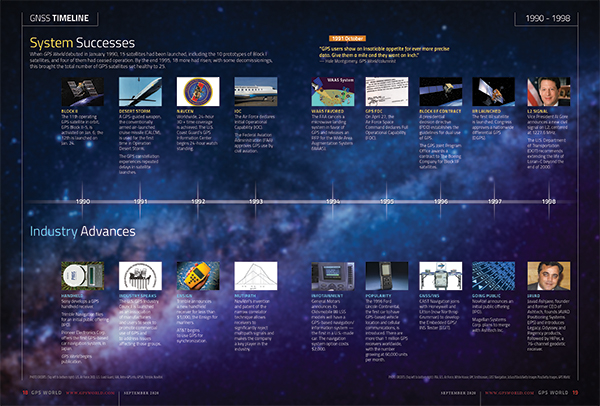
I will end with a quote from an early GPS World columnist, Hale Montgomery, who wrote in October 1991, “GPS users show an insatiable appetite for ever more precise data. Give them a mile and they want an inch.”
Seeking back issues: I have the entire collection of GPS World’s print edition, except for the first issue, the 10 issues in the second year (1991), and the September through December 1993 issues. I would be thrilled to receive those missing issues, or facsimiles, from anybody who has them. Email [email protected].
GPS World’s 30th anniversary GNSS timeline provides highlights in both system and policy development and industry over the past three decades. The timeline originally appeared in the September 2020 Special 30th Anniversary Supplement. Download the PDF.
Terence James (Terry) McGurn, former GPS World Editorial Advisory Board member and long-time CIA analyst, died on Aug. 28 at the age of 84, according to an obituary in the Fairfax (Virginia) County Times.
After a long career in the CIA and U.S. government, McGurn served as a member of the GPS Independent Assessment Team and its successor, the National Space-Based Position, Navigation and Timing Advisory Board. The board provides independent advice to the National Executive Committee on GPS-related policy, planning, program management, and funding profiles in relation to the current state of national and international satellite navigation services.
McGurn also served as a member of the Independent Review Team sponsored by NASA, which bridged civil and military communities’ GPS issues. He also served on various ad hoc teams that address the criticality of satellite navigation to the nation’s military and civil infrastructure.
He was a member of the GPS World Editorial Advisory Board and was an active member of the Institute of Navigation. He served the CIA and the broader U.S. government until days before he passed away.
McGurn was born in Springfield, Massachusetts on Aug. 24, 1935. He grew up in Jersey City, New Jersey, and he graduated from St. Peter’s Preparatory School in 1953. He moved up his draft and served as a radio operator in the 3rd Armored Cavalry Regiment, and then was discharged as an SP-3 in 1956.
He earned a bachelor’s and masters’ in electrical engineering from the New Jersey Institute of Technology and was Asst. Professor of Physics at NJIT, 1960-69. He earned his doctorate in Electrical Engineering at Stevens Institute of Technology in 1969.
Terry spent his career at Central Intelligence Agency. A senior analyst and leader, he was appointed to the Senior Executive Service (originally Senior Intelligence Service) where he advised generations of policy leaders and operational leaders of the capabilities of the navigation and positioning of the U.S .and of adversaries and other nations.
At the CIA, he developed and implemented methodologies that improved the intelligence community’s ability to assess the performance of foreign weapon systems. He also initiated outreach programs to provide the agency’s unique resources to the departments of Defense, State and Transportation in support of U.S. military, political and economic objectives.
As an expert on the strategic and tactical weapons systems and navigation, guidance and control technologies deployed by potential adversaries, he was able to provide guidance to policy makers regarding the defense of the homeland and of military installations around the world. He briefed at the SECDEF and National Security Council level for decades.
He retired in 2000, the recipient of the CIA Career Intelligence Medal, and numerous Exceptional Accomplishment and Exceptional Performance Awards.
As a consultant, he continued to work with CIA and other agencies in the government, including the DOD, State, the newly established Department of Homeland Security and the Department of Transportation, providing technology and analysis for their diverse missions including security issues related to satellite and terrestrial navigation worldwide.
A long-time resident of Reston, McGurn passed away peacefully at Reston Hospital. He will be laid to rest at Arlington National Cemetery. Reminiscences, condolences and photographs will be posted on this website in the coming months. Memorial donations can be made to the Leukemia and Lymphoma Society or the Animal Welfare League of Arlington.
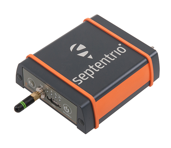
Septentrio’s SECORX-S GPS/GNSS receiver product line offers sub-decimeter accuracy without the need for additional positioning service subscriptions.
The mosaic-Sx module. (Photo: Septentrio)
Septentrio has expanded its SECORX-S product line. The multi-constellation multi-frequency GNSS receivers of the SECORX-S family deliver sub-decimeter positioning out of the box, without the need for any additional correction service subscription or maintenance.
Users benefit from always-on high accuracy provided by a PPP-RTK correction service integrated directly into Septentrio’s latest core GNSS technology. The SECORX-S product line, already including GNSS OEM boards, now also offers a compact mosaic-Sx module as well as a ruggedized receiver in an IP68 chassis, AsteRx SB Sx.
By adding modules and boxed receivers to the SECORX-S product line, Septentrio brings its innovative approach of plug-and-play accurate positioning to industrial applications including precision agriculture, UAV, robotics and construction.
The AsteRs-m2-Sx. (Photo: Septentrio)
Receivers of the SECORX-S family offer lifelong sub-decimeter accuracy in U.S. and Europe. The PPP-RTK correction service integrated in these receivers uniquely combines near-RTK accuracy with short convergence time.
“By launching the SECORX-S product family a few months ago, we have taken a ground-breaking step towards easy-to-use and accessible high-accuracy positioning,” said Francois Freulon, head of product management at Septentrio. “Our SECORX-S product range now includes compact modules, versatile OEM boards as well as boxed receivers. With this expansion of the product family our customers now have the flexibility to choose from a wider range of receivers, the one that perfectly fits their needs.”
On Aug. 19, the U.S. Federal Communications Commission (FCC) granted a request for authorization from AT&T Services to use Galileo for emergency location purposes.
AT&T plans to use Galileo in conjunction with GPS to improve the accuracy of its E9-1-1 location services on mobile devices, and facilitate faster response from emergency services when wireless callers dial 9-1-1.
The request was approved by the FCC’s Public Safety and Homeland Security Bureau .
The FCC found that AT&T had satisfied the conditions for commercial mobile radio service (CMRS) providers to integrate foreign satellite signals into E9-1-1 services.
Under E9-1-1 requirements established in 2015, CMRS providers seeking to use foreign signals for E9-1-1 services must meet several conditions, including ensuring that integrating non-U.S. signals won’t cause interference with the E9-1-1 system.
Carriers also need to submit a signal integration plan including a mechanism to detect, mitigate and disable Galileo signals if they cause harmful interference.
“We cannot have GPS signals be a single point of failure for transportation and other critical infrastructure sectors. More safety applications will depend on PNT in the future. Public confidence in these will be critical.
“People will not be comfortable getting into an automated vehicle or with platooning driverless trucks heading down the highway if they think that their invisible hand is not reliable and that their GPS might be spoofed.
“Getting public adoption of other PNT capabilities — space-based, terrestrial, and self-contained — integrated with GPS technology will be critical to the success of any such system.”
— Diana Furchtgott-Roth, Deputy Assistant Secretary for Research and Technology, U.S. Department of Transportation, Nov. 20, 2019, Edinburgh, U.K.
A Single Point of Failure
The Department of Transportation (DOT) is responsible for leading civil positioning, navigation, and timing (PNT) issues for the United States. At the moment, the U.S. GPS provides the vast majority of PNT services in the U.S. and around the world. Yet, like all space-based systems, its signals are weak and very vulnerable to interference.
A recent example of how dangerous that can be in automated transportation systems was revealed recently in an accident report released by the British government. Interference from an unknown source caused a 15.5 kg drone to get away from its operator and crash. Fortunately, no one was hurt. The report cited analysis showing that such a weight could have easily killed someone on the ground.
Even more concerning, GPS signal characteristics are well known and therefore easy to imitate. Thousands of cases of “spoofing” have been documented with government and malicious actors causing receivers to report they are far from their actual location. In the worst cases, this can cause accidents or enable criminal acts.
One result of all of this is the President of the United States issuing an Executive Order encouraging “responsible use” of PNT systems. It also directs steps to encourage development and adoption of alternative systems. This includes a White House-level plan for research and development of non-Global Navigation Satellite System (GNSS) PNT.
In Europe the European Union (EU) has warned that space based PNT alone is insufficient for “…critical applications requiring continuous availability and fail-safe operations.” The EU has also established a monitoring system to detect sources of GNSS interference, and the European Space Agency (ESA) has established an on-going program funding study of both space and terrestrial alternate PNT systems.
Multiple Cooperating Systems
The ultimate solution, though, according to senior government officials, will be development and use of many diverse PNT systems working together to ensure users have what they need when and where they need it.
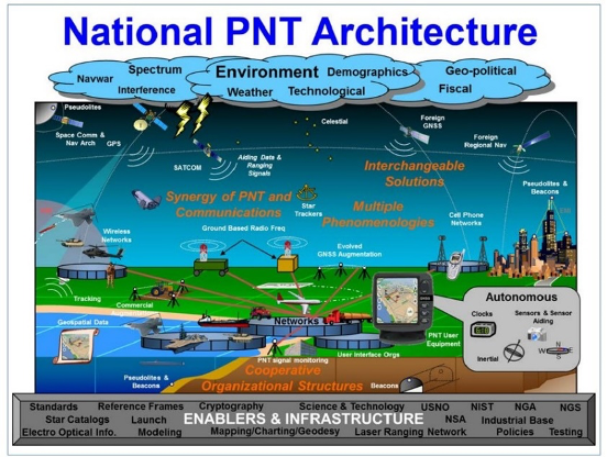
Image: DOT
The National PNT Architecture, jointly developed by the US departments of Defense and Transportation, envisions a multitude of PNT sources ranging from GNSS provided by national governments, to inertial and clock suites acquired by users as needed.
“Many people are fond of talking about a GPS backup,” said one administration official.
“It’s more appropriate to use the plural ‘backups’ since one system isn’t going to meet everyone’s needs. Even GPS doesn’t meet everyone’s needs which is why we require complementary PNT capabilities.”
The idea that multiple redundancies are required for an essential function as long been a core principle of systems engineering. This is clearly foundational in the National PNT Architecture.
It is also a feature in more recent documents.
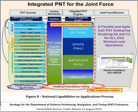
One example is the U.S. Department of Defense’s (DoD) PNT strategy publicly released in August of last year. It envisions use of a multitude of systems as a way of “Ensuring a U.S. Military PNT Advantage.”
Image: DOD
It categorizes these in three layers. A global layer of GNSS and other satellites, a regional layer that includes STOIC and eLoran, and a local/autonomous layer populated by inertial, clock, lidar, radar, scene matching and beacon-based systems.
Another project taking the architecture approach is described in detail by the recently completed MarRINav report. Sponsored by the European Space Agency, it analyzed the PNT needs of maritime commerce in the United Kingdom.
The project concluded that a “hybrid approach” using GNSS, eLoran, and the short-range R-mode VDES would be the best and least expensive combination for maritime. It also recommended a local navigation system such as Locata for port cargo operations. The study found that such a combination of systems would also benefit other transportation and infrastructure sectors.
Implementation
Yet identifying solutions is often much easier than making them happen. Especially for national projects with dozens of stakeholders. Stakeholders who may often have competing interests. And there is always the question of “Who pays?”
In the United States both the Congress and the executive branch of the U.S. government are addressing these issues, and in potentially complementary ways.
Congressional Mandates. With GPS as the cornerstone, both the DoD strategy and the National PNT Architecture show the need for one or more complementary systems to “overcome PNT capability gaps, predominantly resulting from the limitations of GPS.”
According to one senior official close to the issue, these systems need to be, “integrated with GPS and each other” and within the U.S. “serve all parts of the country — urban, rural, wilderness — even coastal maritime areas.” The idea being that they will constantly reinforcing GPS services while also serving as a safety net for users when during GPS disruptions.
The National Timing Resilience and Security Act of 2018 requires DoT to begin filling this layer in the National Architecture by the end of this year. The law, passage of which was overwhelmingly supported by both parties, mandates the department establish a difficult to disrupt, wide area, terrestrial timing system to backup (and complement) GPS timing signals. The system also must be expandable to provide navigation services. Even as a timing service, though, it has the potential to make navigation more reliable. Studies have shown that combining such a timing signal with GPS and other GNSS signals can dramatically decrease users’ vulnerability to jamming and spoofing.
The law also enables the system or systems to be established by leveraging commercial entities and expertise through cooperative agreements, public-private partnerships, and similar arrangements. These tend to be the most expeditious and least costly methods for putting such services in place. As such, they are expected to be very attractive to government program and contracting officials.
On military side, the in-process National Defense Authorization Act for 2021 requires DoD to quickly complete this part of their architecture also. Hinting that the department has failed to respond to combatant commanders “Joint Urgent Operational Needs,” it directs DoD to provide warfighters non-GPS PNT by 2023. It also directs the department to “enable civilian and commercial adoption of [these] technologies and capabilities”.
Presidential Order. The administration’s approach is outlined in a February 2020 presidential Executive Order. The order focuses on commercial entities that contract with the government, critical infrastructure, and research and development.
It calls for, within the next 24 months, agencies to “develop contractual language for inclusion … n the requirements for Federal contracts … with the goal of encouraging the private sector to use additional PNT services and develop new robust and secure PNT services.” The hope is that these new services will be adopted beyond just those companies who routinely serve government needs.
The departments of Energy, Transportation, and Homeland Security are also required to publish plans on how they will engage various critical infrastructure sectors to evaluate the degree of responsible use of PNT by each.
Also, the White House Office of Science and Technology Policy (OSTP) is tasked to “coordinate the development of a national plan… for the R&D and pilot testing of additional, robust, and secure PNT services that are not dependent on global navigation satellite systems (GNSS).” OSTP has already begun this and is seeking input from the public.
Competition and Many Players
Because PNT user needs are so varied and nuanced, most industry observers see growing opportunities for existing and potentially new providers.
“Systems and equipment that improve GNSS services, or that complement and augment GNSS are likely to find ready markets,” said Andrew Bach, a consultant on financial and other PNT issues. “User demands and needs are only going to become more sophisticated as their economic exposure increases.”
Congressional and administration focus on alternative PNT should enhance and multiply such opportunities. So, while there may be no silver bullet for solving national PNT concerns, the need for a robust and resilient architecture of PNT systems will likely mean abundant opportunities for providers.
When I was a kid in the 1960s, I was entranced by the vision of the future. Decades later, we’re here, with personal jetpacks nowhere in sight. What gives?
Photo: Photo: ridvan_celik/E+/Getty Images
When I was a kid in the 1960s, I was entranced by the vision of the future offered by science fiction books, movies, television shows and comics. Advances in technology would deliver us so many wonders — flying cars, hoverboards, robot servants. Disneyland was in on it, with an entire section of the park named Tomorrowland and its now-quaint “Carousel of Progress” attraction.
But the coolest thing would be that jetpack. You could slap it on your back and take off into the atmosphere, traveling wherever you wished like a bird. Certainly by the distant year 2020, we would all be jetting around the atmosphere from place to place.
(It didn’t occur to me that would mean strapping an actual jet engine to my body, along with highly flammable jet fuel. Where’s the fun in that?)
Decades later, we’ve all arrived in the “future,” with personal jetpacks nowhere in sight. What gives?
Then again, what I didn’t imagine in our future was a system that could pinpoint my exact location anywhere on the globe, estimate my time of arrival, and tell me about the traffic up ahead.
Back in the 1960s, that was seriously science fiction. Nor did we accurately predict the effect that capability would have on our daily lives. GPS along with internet-capable smartphones have thrust us into the Information Age.
The internet is a promise delivered, in its own way. Having a repository for all of the world’s information was another future concept, but usually envisioned with a giant worldwide computer that eventually turned on its makers.
As for flying cars, we are gradually getting there. Drone technology, supported by GNSS technology for its navigation, has led to unmanned craft and is heading toward vehicles capable of transporting people. We just need to be a little more patient.
In the spirit of looking back and ahead, check out our 30th Anniversary Supplement, which arrived with this issue. In it, experts from across the industry share memories and thoughts, and gaze into their crystal balls to predict the future of GNSS.