The Mark 3 Plotting Board was used in single-seat aircraft flying in the Pacific. (Photo: National Air and Space Museum, Smithsonian Institution)
On June 25, 1945, in the last few months of World War II, troops from around the globe were headed home and navigation technology was in its infancy.
On that date, the first organization meeting of the Institute of Navigation (ION) took place on the Los Angeles Campus of the University of California with 55 people in attendance. A temporary organization was established to carry on until the fall, when a second general meeting would take place on the east coast.
The first ION Annual Meeting was held Oct. 25–26 that same year at the Hotel New Yorker, with 95 ION members and 35 non-members attending. Proposed Articles of Incorporation were adopted and a council was elected.
By late October, two organizational meetings, two regional meetings and the annual meeting had taken place; bylaws were adopted with plans for incorporation; a permanent organization was established; a National Office was set up at UCLA; and plans were made for future meetings and publication of a journal.
ION’s global impact is documented in more than 2,600 technical papers published in Navigation, the Journal of the Institute of Navigation, first published in March 1946.
On June 25, ION wrote to its members, “Thank you to the thousands of ION members who have committed themselves to our field; and thank you for 75 years of technological advancements that have helped us all discover where we are, where we are going, and when we will get there.”
The U.S. Department of Homeland Security “did exactly what was required by Congress” in issuing its report in June on positioning, navigation and timing (PNT), according to a letter sent by numerous PNT companies to the DHS.
The July 17 letter to Chad F. Wolf, acting secretary of Homeland Security, refutes a previous letter from Congressional representatives that the report contained numerous errors and failed to address many of the things Congress had required.
“We believe that some key claims made in the members’ letter of June 9 are either exaggerated, irrelevant to the report’s Congressional tasking, or simply wrong,” states the July 17 letter, which is signed by senior executives of Satelles, Orolia, Iridium, Navsys, Jackson Labs, Seven Solutions and Qulsar.
The group takes on the claims of the representatives point by point, finding them exaggerated, irrelevant or incorrect.
For instance, the letter critical of the DHS report states:
“The report focuses on the needs of ‘industry’ largely ignoring the needs and impacts on public services (including first responders), government operations, and individual citizens.”
In response, the industry representatives state:
“The focus of the report, as directed by the NDAA, is on the requirements of the owners and operators of national critical infrastructure. This includes “public services, government operations,” and its beneficiaries, “individual citizens.” To the extent that the report focuses on incentivizing the industry, it is in order for it to be able to meet these requirements.
“While the report only highlights PNT use cases from a subset of the 16 critical infrastructure sectors, their pragmatic recommendations address a range of requirements across all sectors. With respect to PNT needs for backing up GPS, DHS acknowledges the differences between and commonalities among the sectors and offers exceptional guidance for leveraging the capabilities of diverse forms of commercially available alternative PNT rather than endorsing a single, anti-competitive, government-imposed solution.”
Last week, 27 members of the U.S. House Agriculture Committee sent a letter to Federal Communications Commission (FCC) Chairman Ajit Pai. In it, they urged him to reconsider the FCC’s decision to allow Ligado Networks to operate a terrestrial nationwide network that the executive branch says will cause harmful interference to GPS signals for many users.
This concern and opposition from a sector not traditionally engaged in GPS or positioning, navigation and timing (PNT) issues is just one example of how the FCC’s decision — rather than putting the issue to rest — has instead recruited a whole new set of actors from across multiple sectors for the opposition.
Many observers don’t see this as surprising.
According to one observer, previously it was easy for many to assume the FCC would reject Ligado’s proposal. The entire executive branch had been vehemently opposed for years. So had aviation groups, the weather community, geospatial interests and some satellite communications concerns. With such opposition from so many important quarters, it was reasonable for many to assume they need not become involved. Now that the FCC has acted to the contrary, these interests have become well energized.
The FCC decision also empowered opponents to educate and recruit others who don’t normally think or worry about GPS and PNT issues, folks like farmers and agricultural interests.
As one insider said, “The existing opposition can now go to just about anyone in any sector and say, ‘This is going to happen and it will harm your operation. There are no ifs, ands, or buts. The FCC has decided’.”
Photo: Avalon_Studio/E+/Getty Images
Agriculture’s reliance on GPS
Agriculture is a good example. While not the sector that first springs to mind when most people think about GPS, farming has become dependent on augmented GPS for precisely and automatically driving machinery, minimizing fertilizer and pesticide use, and a wide variety of other productivity gains over pre-GPS operations.
“GPS is critically important to the commercial agriculture, mining, forestry and rural manufacturing industries. In fact, GPS has become the single most significant technological advancement for American farm equipment in the past two decades… [A 2019 RTI study] found that during planting season, if GPS were interrupted, the economic impact to the agriculture sector could amount to losses of $15 billion due to lower crop yields. Moreover, an earlier study suggested GPS-enabled precision agriculture could save farmers an estimated 10 to 15 percent in operating costs and purchased inputs. This same study estimated the benefits of GPS to precision agriculture between $10 and $17 billion.”
Department of Transportation studies have shown that high-precision GPS receivers, such as those used in agriculture, could be impacted within 3,000 meters of a Ligado transmitters. With tens of thousands of transmitters deployed in a nationwide network, this could pose a real problem for American farming.
Other sectors have also become involved in the opposition. The recently formed Keep GPS Working Coalition has members representing aviation, surface transportation, maritime, agriculture and equipment manufacturing.
This formal and public coalition, though, seems to be just the tip of the opposition iceberg.
Almost 100 dissenting organizations
According to some involved with protesting the FCC’s decision, there are nearly a hundred organizations and companies that are working in some way to have it overturned. These include multiple aviation, delivery service, agriculture, surface transportation, geospatial, weather, maritime, space and technology interests.
One sign of the influence they are having is an increase in concerns being expressed by members of Congress.
In addition to the agriculture letter, some of the most powerful recent examples are statements made during meetings of the influential House Committee on Appropriations. Rep. Ken Calvert (R-CA), ranking member of the Defense Appropriations subcommittee, spoke at length in opposition to the FCC’s action. His comments were followed in a similar vein by the vice chair of the Appropriations Committee, Rep. Peter Aguilar (D-CA).
Many of the questions being asked by the public and members of Congress alike were reflected in the letter from the Agriculture Committee members:
How did the FCC know that “its” tests were representative and valid?
Why does the FCC find that some degradation of GPS reception is acceptable?
Why did the FCC reject the executive branch’s testing criteria?
Was there a cost/benefit analysis?
The letter also asked the question that is on almost everyone’s mind: If and when there are problems, who is going to fix them?
A new monitoring system developed through an ESA-backed project works like a bodyguard for satellite navigation in use at strategic or safety-critical sites. Known as GIDAS, the scalable system immediately detects, identifies and pinpoints satnav interference sources in its vicinity.
It is estimated that there are currently the same number of satnav receivers on Earth as there are people. Positioning, navigation and timing signals from space-based constellations such as Galileo and GPS form an invisible, essential infrastructure, underpinning numerous modern aspects of modern life: communications, power and transportation.
Satellite navigation helps guide a growing number of aircraft, boats, trains and autonomous vehicles. Meanwhile satnav-based time stamps authentic multi-billion euro financial transactions, and coordinate the synchronised running of power grids. Satellite navigation is always on, available everywhere on Earth, so it is easy to take its availability for granted. But as crucial as these signals from space are, they are also vulnerable to ground-based interference.
“It’s simply a matter of output power,” said Andreas Lesch of Austria-based OHB Digital Solutions. “A navigation signal on the ground is equivalent to the light from a 60-watt lamp aboard a satellite, some 23,222 km away in space in the case of Galileo. So these faint signals can be jammed by more powerful local radio signals, either accidentally or deliberately, or even misleading fake navigation signals, known as spoofing.”
“Our new GNSS Interference Detection and Analysis System, GIDAS, is designed to safeguard critical infrastructure against jamming or spoofing, by performing continuous monitoring of key signal bands. By doing so, GIDAS can raise the alarm in real time, identify the type of interference then pinpoint the location of these dangerous portable devices causing the interference so the authorities can take immediate remedial action.”
GIDAS can provide interference detection and directionality with a single reporting station, although a minimum of three stations are required for pinpointing interference sources, linked to an overall monitoring center. Monitoring centers can also be connected together, making the GIDAS system easily scalable, from safeguarding an individual harbour, airport or system critical site up to an entire city or region.
GIDAS can provide interference detection and directionality with a single reporting station, although a minimum of three stations are required for pinpointing interference sources, linked to an overall monitoring center. (Photo: ESA)
“People are only now catching up to the seriousness of this problem,” adds Andreas. “Surveys of the highest-density parts of Europe surveys report around three to four jammers hourly.
“These small devices are technically illegal but are easily available online for a few hundred euros or less, often marketed as personal privacy devices. Jammers are sold as having a range of only a few metres, but can turn out to have a practical range of dozens of metres or more — leading to unintentionally widespread interference, like the famous jammer-equipped U.S. truck driver who shut down Newark Airport navigation systems whenever he drove past.
“Spoofing is more serious still, with a strong criminal element, where false satellite navigation signals replace real ones, to mislead receivers about their position, employed in the past to down put drones or divert boats.
“Working in this field for eight to nine years, we have seen a strong growth in interference, even as GNSS becomes ever more crucial. With our passion for GNSS and signal processing, we decided to something practical to combat this development, delivering rapid detection, classification and localisation of interference to our customers.”
GIDAS was developed by OHB Digital Solutions and Joanneum University through ESA’s Navigation Innovation and Support Programme (NAVISP), working with European industry and academia to develop innovative navigation technology.
“The company initiated the project through NAVISP’s second element, focused on strengthening European competitiveness in the navigation arena, proceeding on a co-funded basis,” said engineer Thomas Burger, overseeing GIDAS project for ESA. “The plan was to enable a commercially attractive business to get started, and I’m happy to say we made it.”
“Considering the budget, the project had a wide scope, including the development of a multi-constellation GNSS receiver with all processing stages, an extended digital front end for jamming and spoofing detection, processing blocks transferred to a parallel processor based on a customised fully programmable gate array.
“And that was only one ingredient of the overall GIDAS system, also including the actual interference detection machinery, the interference locating subsystem, and all the communication, database, and graphical user interface elements needed to create a distributed, human-usable system — which is able to go on working autonomously, only asking for human involvement when events are detected.”
Now that its two-year NAVISP project has concluded, GIDAS is now being rolled out to several Europe-based governmental and private sector customers.
The contest targets the design and development of drone-based applications or services, using a Galileo-enabled receiver, to address the European Union’s (EU’s) key priorities such as the Green Deal, and support the EU Recovery Plan for Europe.
Initial ideas should be submitted by Aug. 31. Wide participation from all EU Member States is expected.
According to ESA, the MyGalileoDrone competition seeks to tap into the EU’s innovative spirit to deliver applications and services to boost Europe’s competitiveness, resilience and sustainability. Applications should leverage and demonstrate Galileo’s added value, such as increased accuracy, availability and robustness of position, as well as integrity for a solution based on drone operations.
The market related to drone applications and services is growing rapidly, and European drone service revenues are expected to reach EUR 250 million by 2025. The European demand is estimated to reach EUR 10 billion annually, in nominal terms, to 2035 and over EUR 15 billion annually to 2050, creating more than 100,000 jobs.
With GNSS receivers implemented on almost all new commercial drones, Galileo’s and EGNOS’ added value is pivotal for the development and growth of drone services and applications.
In addition to designing and developing the application, contestants should prepare their drone- based application or service for commercial launch.
The solution should leverage Galileo to provide a position fix. The use of EGNSS is understood in the broad sense, and Galileo can be integrated in the flying platform, the ground control station, or in other devices supporting the operation, such as a smartphone or even in the frame of U-Space services.
“GNSS is a key enabling technology in this segment, ensuring robust navigation and reliability for a wide range of applications. The MyGalileoDrone competition aims to bring oxygen to European SMEs and entrepreneurs driving innovation. It will create jobs and growth in this promising market,” said Pascal Claudel, acting executive director at the GSA.
Focus on EU priorities
In times of post-COVID recovery focus, submissions should target applications and services that support key EU priorities, but the sky’s the limit. The GSA is looking for trailblazing ideas in applications such as smart mobility, sustainable agriculture or environmental protection, or solutions that exploit synergies between 5G and space data, or support the internet of things, or whatever might be the next big thing.
Deadlines and Prizes
The first prize in the MyGalileoDrone competition amounts to EUR 100,000, with EUR 60,000 for second, EUR 40,000 for third, and a fourth prize of EUR 30,000.
After Aug. 31, projects selected to advance to the development phase of the contest will be announced on Sept. 15. Participants will have until Nov. 30 to develop a demo version of their proposed application or service.
In the finals, the selected teams will perform a live demonstration and pitch their ideas to investors. During the development process, the applicants will receive mentoring and coaching from recognized experts in the drone market. These experts will accompany them as they build their application, develop tests and get ready from the business perspective to attract investors and move to market.
To register or for more information, visit the competition page on the GSA website.
GMV will search using artificial intelligence for any correlations between COVID-19 spread and environmental parameters.
Image: ESA
The European Space Agency (ESA) has launched an internal initiative to cull ideas for supporting its member states in the study and analysis of the COVID-19 pandemic. Under this initiative, an idea from the Galileo Navigation Science Office has been selected.
The COVID-19 Space Hunting Platform is designed to facilitate access to and processing of existing COVID-19 databases for epidemiological studies, topping them up with data from ESA’s Earth observation satellites.
The project will use artificial intelligence to look for correlations between COVID-19 spread and environmental parameters, such as humidity and temperature.
The aim is to help researchers generate products and statistics that might be useful for decision-making purposes in terms of protection measures and lockdown, while also vetting the efficiency of the measures taken.
Development of the COVID-19 Space Hunting Platform will be primed by the technology multinational GMV. The Universidad Politécnica de Valencia will also be taking part, with support for processing, data analysis and interaction with diverse epidemiological research groups. The university has defined a mathematical COVID-19 transmission model and has been publishing periodical updates and forecasts of its trend in Spain.
In the medium term, the COVID-19 Space Hunting Platform could help in setting up a collaborative COVID-19 website for scientists to analyze existing data more efficiently, benefiting also from ESA’s data-processing software packages.
The GSSC team will lead the program. (Photo: ESA)
The project will be carried out around the GNSS Science Support Centre (GSSC) platform, which hosts and indexes COVID-19 data. The three-month process will analyze public COVID-19 data and make this information available to the science community. This will lead to a first version with basic pandemic-propagation algorithms, updated thereafter to ensure the information is always precise and up to date.
At first it was a flurry of letters and public statements from U.S. senators and members of the house. Then there was a senate hearing on the topic, and the issue was discussed in several other hearings.
The Federal Communications Commission’s (FCC) approval of a long-standing request by Ligado Networks continues to be controversial. The request was to make terrestrial broadcasts on a frequency near that used by GPS. Broadcasts which, according to analyses by the departments of Defense and Transportation, will interfere with GPS reception for many users.
Now it looks as though Congress is ready to move beyond talk and enact one or more pieces of legislation. These would require an independent technical review of the FCC’s decision and place limits on the ability of Ligado Networks to use the license it was granted.
Congressional interest has been fueled both by member concerns and a regular drumbeat of input from constituents. The recently formed Keep GPS Working Coalition is just one example. It was created from a larger group of more than 70 companies and organizations across a broad swath of industries that has gone on record against the decision and has been supporting congressional action.
National Defense Authorization Act
A primary vehicle for congressional action looks to be the National Defense Authorization Act (NDAA) for 2021. Unlike other “annual” legislation that often gets sidetracked or delayed during election years, Congress has passed an NDAA for each of the past 59 years. As such, it is a particularly powerful tool.
This is doubly so in this case, as the member of Congress that has been the most outspoken critic of the FCC’s decision is Senator Jim Inhofe (R-OK). He chairs the Senate Armed Services Committee that has direct responsibility for the NDAA.
Responding to conflicting claims about the findings of government and private tests, the bill requires the Defense department to contract with the National Academies of Science, Engineering and Medicine for an independent technical review.
Evaluating Potential Impact on GPS
Among other things, the review will compare the different methods of evaluating the potential impact on GPS services from Ligado’s transmissions, and determine which of those was the most effective in guarding against any harm.
The bill also prohibits the Defense Secretary from spending any money to comply with the FCC’s order until the Congress has been given an estimate of the total cost to the department of coping with Ligado’s transmissions.
While the FCC order requires Ligado to modify or replace any government receivers impacted by its operations, the Defense department and others have said this is only a small fraction of the overall costs they would incur.
The bill requires the Defense Department estimate to consider a much larger scope of costs including:
To upgrade, repair, or replace potentially affected receivers
To modify, repair, or replace equipment, pares, associated ancillary equipment, software, facilities, operating manuals, training, or compliance with regulations, including with regard to the underlying platform or system in which a capability of the Global Positioning System is embedded; and,
For personnel of the department to engineer, validate, and verify that any required remediation provides the Department with the same operational capability for the affected system prior to terrestrial operation in the 1525 to 1559 megahertz or 1626.5 to 1660.5 megahertz bands of electromagnetic spectrum.
The House version of the NDAA also provides that:
“The Secretary of Defense may not enter into a contract, or extend or renew a contract, with an entity that engages in commercial terrestrial operations using the 1525–1559 megahertz band or the 1626.5–1660.5 megahertz band unless the Secretary has certified to the congressional defense committees that such operations do not cause harmful interference to a Global Positioning System device of the Department of Defense.”
RETAIN GPS and Satellite Communications Act
Senator Inhofe has also announced he will introduce stand-alone legislation when Congress returns from summer recess. His “Recognizing and Ensuring Taxpayer Access to Infrastructure Necessary for GPS and Satellite Communications Act,” or “RETAIN GPS and Satellite Communications Act,” would require Ligado to modify or replace any receiver, including those used by private citizens, that would be impacted by Ligado’s operations.
This modification would be required before the FCC’s order allowing them to transmit could come into force. Most observers opine that the number of impacted civil receivers in the U.S. is so great that this would effectively deny Ligado use of the frequency.
Introduction of the RETAIN GPS and Satellite Communications Act was planned for before the summer recess. Its delay until after was likely to provide more time to recruit co-sponsors.
GPS Interference a ‘Niche’ Issue
One observer commented that “GPS and the FCC Ligado order are really niche issues. As time goes on, more and more members of Congress will hear about it from constituents and be appalled.”
The delay will also allow time for the mammoth NDAA bill to clear Congress. RETAIN GPS would then have more chance for the spotlight.
Many industry observers have opined that regardless of congressional action, Ligado will struggle to find a successful 5G or other business model that will generate a significant revenue stream from the spectrum.
As public concern continues to grow and Congress responds with legislation, it may turn out that Ligado finally won the battle at the FCC but ended up losing the war.
The annual ION GNSS+ 2020 Conference scheduled to take place Sept. 21-25 in St. Louis, Missouri, will now be held entirely virtually.
The Institute of Navigation (ION) made the decision after careful consideration and in light of COVID-19 and the domestic and international travel restrictions that make it impossible for many speakers and participants to participate in person, the organization stated.
“The virtual platform is the best way to deliver a meaningful technical program experience to all participants,” said Lisa Beaty, executive director.
ION GNSS+ 2020 VIRTUAL will be held over the original dates, Sept. 21-25, in Central Daylight Time and will live stream the plenary and all panel keynote sessions, including the Civil GPS Service Committee meeting, through the virtual web platform. These sessions will also be recorded and uploaded for viewing at a later time. Interactive question and answer will take place virtually.
Individual technical presentations will be pre-recorded and uploaded with slides to the ION GNSS+ 2020 VIRTUAL site each morning for viewing at a later time. Attendees will have the option to submit questions to each presenter. Details can be found in the online program.
Recognizing that industry partners want to connect with ION GNSS+ 2020 VIRTUAL attendees, ION is providing an expanded online exhibitor profile that allows exhibitors to upload a complete company profile with sales information, upload their company logo and company brochures, and will include complete contact information that allows attendees to email an exhibitor directly to ask questions or set up a phone or virtual appointment.
The Institute of Navigation is offering free conference registrations for ION GNSS+ first-time attendees (some restrictions apply) and a COVID-19 economic impact discounted virtual registration fee.
For more information on ION GNSS+ 2020 VIRTUAL, go to www.ion.org/gnss.
Not surprisingly, the primary topic at the July 1 meeting of the National Space-based Positioning, Navigation and Timing Advisory Board was the Federal Communications Commission (FCC) decision on Ligado Networks.
In it Captain Sullenberger cited many of the issues the board’s vice chair, Brad Parkinson, discussed later in the meeting. Sullenberger’s statement is available here.
In his presentation, Parkinson called the FCC decision “a grave error.” He outlined his rationale in 21 information-packed slides.
Parkinson summarized his presentation up front with three points:
Repurposing the Mobile Satellite Services (MSS) radio spectrum is very high risk and brings virtually no near-term benefit to the United States.
The risks affect much more than the Department of Defense: high-value civil applications are also in jeopardy.
Any such repurposing should have been subject to a formal rulemaking process.
At the end of the presentation, the board voted unanimously to adopt the presentation, with slight modifications, as a reference document for posting on the board’s website.
The group had previously made strong recommendations to the Departments of Defense and Transportation to oppose any such action by the FCC. Both departments have done that and are continuing to do.
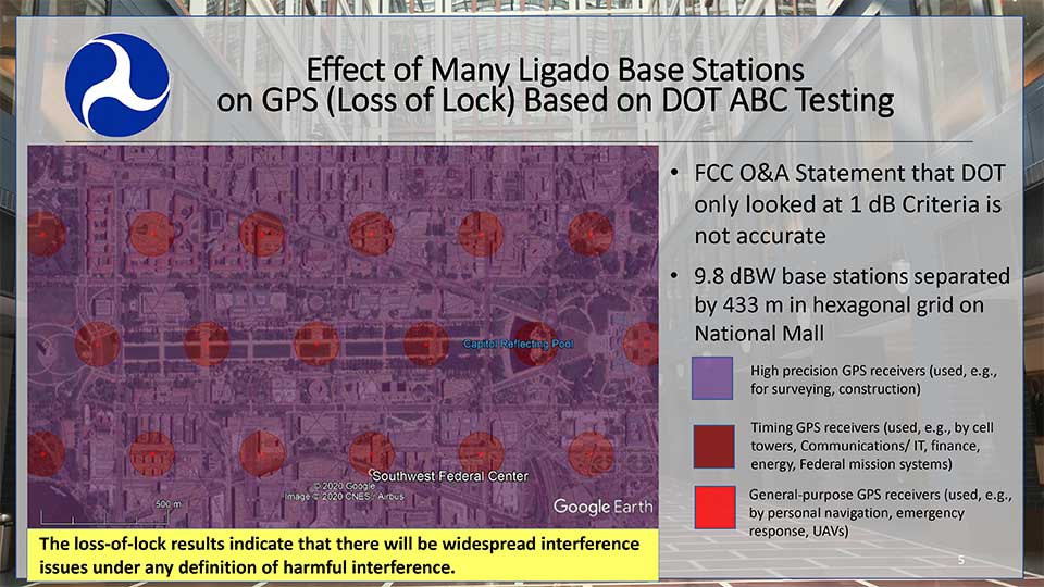
Hazardous information versus losing lock
One slide in Parkinson’s presentation included a Department of Transportation (DoT) depiction how of Ligado transmissions would cause several types of receivers to “lose lock.” This graphic was used in a recent DoT presentation to the FCC.
DOT briefing to FCC: “Concerns Over Ligado Order & Authorization,” June 2020. (Slide: DOT)
Heretofore DoT has usually discussed the points at which Ligado transmissions would cause a 25% increase in the noise floor for receivers. This is an important metric as tests have shown that beyond that point many receiver types begin to give hazardously misleading information. DoT officials have used the example that the 1dB limit is like putting a load limit on vehicles crossing a bridge so that the bridge never reaches its breaking point. An important consideration with a safety-of-life application like GPS.
The National Space-Based PNT Advisory Board. (Board photo)
A receiver often gives inaccurate positioning and timing data, possibly hazardously misleading information, before it “loses lock” and stops providing any information at all. It is more difficult for a receiver to “acquire lock” than to track satellites and provide information, so equipment is rarely able to function again until it moves out of the area of interference.
When asked why DoT would bother to show such information to the FCC, one official suggested that loss of lock was more in line with the criteria the Commission used in making the Ligado decision. The hope was that, by showing that even this flawed standard had significant impacts which the FCC perhaps did not fully recognize, further technical discussions and reconsiderations could be realized.
Other Topics
While discussion of the FCC’s decision took the most time in the on-line meeting, several other issues were discussed as well.
Colonel Curtis Hernandez from the National Security Council briefly described development of a new space-based PNT policy to replace NSDP-39 which was put in place by President Bush in 2004.
He was not able to provide any specifics as it is a draft and still under consideration. Answering a question, he did say that the draft policy outlined the responsibilities of various departments, including for interference detection and monitoring.
Adam Balkcum from the Office of Science and Technology Policy discussed his office’s nascent efforts to investigate non-GNSS PNT as directed by the recent Executive Order on Responsible Use of PNT. The question of whether this includes possible PNT services from low earth orbit and geostationary satellites remains an open one.
Other presenters included:
Seth Jonas of the National Security Council staff on the recent Executive Order on Responsible Use of PNT,
Andrew Hansen of the Volpe Transportation Systems Center who spoke about efforts to monitor for GPS interference, especially in the post-FCC Ligado decision environment, and
NASA’s Chris Bonniksen discussed issues with operating and funding the agency’s Global Differential GPS system.
The agenda for the meeting and presentations are available here, as will be the meeting minutes once they have been finalized.
Third Lockheed Martin-Built GPS III satellite climbs to orbit on its own power
GPS III SV03 increases number of secure military code (M-code) enabled satellites in GPS constellation to 22 total.
After a successful launch on June 30, the third Lockheed Martin-built GPS III satellite headed to orbit under its own propulsion. The satellite separated from its rocket and used onboard power to climb to its operational orbit, approximately 12,550 miles above the Earth.
GPS III Space Vehicle 03 is responding to commands from U.S. Space Force and Lockheed Martin engineers in the Launch & Checkout Center at the company’s Denver facility. There, they declared rocket booster separation and satellite control about 90 minutes after the satellite’s June 30 launch aboard a SpaceX Falcon 9 rocket from Cape Canaveral Air Force Station, Florida.
“In the coming days, GPS III SV03’s onboard liquid apogee engines will continue to propel the satellite towards its operational orbit,” said Tonya Ladwig, Lockheed Martin’s acting vice president for Navigation Systems. “Once it arrives, we’ll send the satellite commands to deploy its solar arrays and antennas, and prepare the satellite for handover to Space Operations Command.”
After on-orbit testing, GPS III SV03 is expected to join the GPS constellation — including GPS III SV01 and SV02, which were declared operational in January and April — in providing positioning, navigation and timing signals for more than four billion military, civil and commercial users.
Lockheed Martin designed GPS III to help the Space Force modernize the GPS constellation with new technology and capabilities. The new GPS IIIs provide three times better accuracy and up to eight times improved anti-jamming capabilities over any previous GPS satellite. They also offer a new L1C civil signal, which is compatible with other international global navigation satellite systems, like Europe’s Galileo, to improve civilian user connectivity.
GPS III also continues the Space Force’s plan to field M-code, a more-secure, harder-to-jam and spoof GPS signal for our military forces. GPS III SV03 brings the number of M-code enabled satellites to 22 in the 31-satellite GPS constellation.
“As a nation, we use GPS signals every day — they time-stamp all our financial transactions, they make aviation safe, they make precision farming possible, and so much more,” added Ladwig. “GPS has become a critical part of our national infrastructure. In fact, the U.S. economic benefit of GPS is estimated to be over $300 billion per year and $1.4 trillion since its inception. Continued investment in modernizing GPS — updating technology, improving its capabilities — is well worth it.”
On June 26, the U.S. National Oceanic and Atmospheric Administration (NOAA) released the summary of the results of Commercial Weather Data Pilot (CWDP) Round 2. View the summary here.
In Round 2, NOAA evaluated GNSS radio occultation data from two U.S. commercial space companies: GeoOptics and Spire. NOAA concludes that, based on the results of CWDP Round 2, the commercial sector is able to provide radio occultation data that can support NOAA’s operational products and services.
“As a result, NOAA is proceeding with plans to acquire commercial RO data for operational use,” the summary states.
According to GeoOptics, the report highlights the unique qualities of its commercial GNSS-RO data and its ability to improve weather and space weather forecasts around the world.
“As today’s report demonstrates, commercial satellite data will enable NOAA to make significant improvements in forecasting worldwide within the consistent budget limitations under which it operates,” said GeoOptics CEO Conrad Lautenbacher.
NOAA anticipates release of a request for proposals soon for operational purchase of commercial radio occultation data, continuing an acquisition process that began in April with NOAA’s release of a draft Statement of Work.
NOAA has requested $15 million in FY 2021 to support Commercial Data Purchase. The FY 2021 Budget also requests $8 million for CWDP to investigate new commercial technologies beyond radio occultation.
By moving into this next phase of engagement with U.S. industry, NOAA is leveraging commercial space sector capabilities to support its operational products and services and to continue to improve its weather forecasting capabilities. NOAA plans to implement additional rounds of the CWDP to evaluate commercial capabilities beyond radio occultation data for potential operational use.
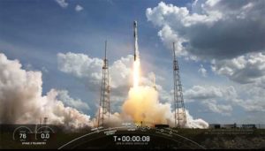
Update (U.S. Space Force news release): The U.S. Space Force and its mission partners successfully launched the third GPS III satellite at 4:10 p.m. EDT June 30 from Space Launch Complex 40 at Cape Canaveral Air Force Station, Florida. The Lockheed Martin-built satellite was carried to orbit aboard a Space Exploration Technologies Corporation (SpaceX) Falcon 9 Launch Vehicle.
“Our team is committed to achieving excellence and reaching the Gold Standard of position, navigation, and timing. GPS III satellites will pioneer innovation and I look forward to seeing new technologies developed for the United States Space Force,” said Cordell DeLaPena, program executive officer for SMC’s Space Production Corps. “At SMC, we are proud to deliver our third GPS III satellite and will continue to operate at a high caliber.”
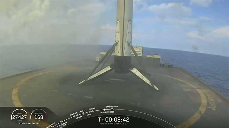
The first-stage booster of SpaceX’s Falcon 9 Launch Vehicle was successfully recovered approximately 20 minutes after liftoff by the company’s autonomous spaceport drone ship in the predicted landing area. This launch marks the first NSSL mission where a launch provider has attempted to recovered flight hardware.
“The successful GPS III SV03 launch and recovery serves as another step in our journey with industry partners to create innovative, flexible, and affordable services to meet NSSL mission objectives and propel U.S. dominance in space.” said Col. Robert Bongiovi, Launch Enterprise director. “I’m proud of my team’s 81st successful National Security Space Launch and look forward to our additional National Security Space missions with SpaceX.”
GPS III’s SV03 separated from its upper stage approximately 88 minutes after launch. Engineers and operators at Lockheed Martin’s Waterton facility will now begin on-orbit checkout and tests which are estimated to complete in two weeks. Operational use is expected to begin as early as August 2020.
“The GPS III program continues to build on its successes by delivering advanced capabilities for the United States Space Force, and maintaining the “gold standard” for position, navigation and timing.” said Col. Edward Byrne, Medium Earth Orbit Space Systems Division chief.
UPDATE: The SpaceX Falcon 9 successfully launched the third GPS III satellite at 4:10 ET. The reusable Stage 1 successfully returned and landed on its launchpad less than nine minutes after launch.
Screenshot: SpaceX live feed of launchSpaceX live feed show Stage 1 returning to landing pad at sea. (Screenshot: Space X)
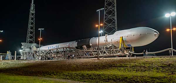
The U.S. Space Force’s newest Global Positioning System (GPS) III satellite, Space Vehicle 03 (SV03), rolled out to Cape Canaveral’s Space Launch Complex-40 launch pad a during the overnight hours on June 27 and 28, ready for launch June 30 at 3:55 p.m. Eastern time.
The Lockheed Martin-built GPS III SV03 is scheduled to launch aboard a SpaceX Falcon 9 rocket. GPS III SV03 will be the third USSF mission launch, the second National Security Space launch (NSSL) mission to be launched on a SpaceX Falcon 9 rocket, and the first NSSL mission where a launch service provider will be attempting to recover the booster.
The launch window opens at 3:55 p.m. EDT and will remain open for 15 minutes. A live-feed will begin 20 minutes prior to the launch, concluding approximately 45 minutes afterward. A simulcast of the broadcast can be viewed at www.spacex.com.
“The NSSL program’s number one priority is to achieve mission success on each and every National Security Space launch,” said Col. Robert Bongiovi, Launch Enterprise director. “We also strive to procure affordable launch services that maintain assured access to space for the Nation. Our goal with GPS III SV03 was to maintain our mission assurance record, while exploring unique cost saving opportunities like recovering a booster to deliver the capabilities our warfighters demand.”
“The GPS III program brings a new standard of excellence for the entire space community. Our production team and contract partners have developed an indispensable tool that is available to military and civil users around the world.” said Cordell DeLaPena, program executive officer for SMC’s Space Production Corps. “Our team will continue to advance the launch campaign for the remaining space vehicles and I anticipate the successful launch of SV03 on the Falcon 9.”
Originally scheduled to launch on April 29, the GPS III-3 mission took a 60-day tactical pause in order to implement new health and safety measures to protect launch and operations crew during the ongoing COVID-19 pandemic. This pause allowed SMC to design and implement these measures in collaboration with contractor and launch provider partners as well as medical professionals. The tactical pause resulted in no impact to the readiness and availability of the GPS constellation, which remains in strong health. There were minimal impacts to cost and schedule due to the pause.
GPS III SV03 will be launched to augment the current GPS constellation comprised of 31 operational spacecraft. GPS satellites operate in Medium Earth Orbit (MEO) at an altitude of approximately 20,200 km (12,550 miles) in six orbital planes. Each satellite circles the earth twice per day.
GPS is the premier space-based provider of positioning, navigation, and timing services for more than four billion users worldwide. This latest generation of GPS satellite boasts a 15-year design life — 25 percent longer than the last generation of GPS satellites on-orbit. GPS III brings new capabilities to users such as the new L1C civilian signal, which opens the window for future interoperability with international satellite navigation systems.
“Our space systems division is filled with exceptional, highly talented team members focused on delivering the next generation of GPS satellites. They are extremely motivated and resourceful, and had to overcome numerous challenges imposed by the COVID-19 pandemic to successfully get us into a position where we can safely launch. I couldn’t have asked for a better team,” said Col. Edward Byrne, MEO Space Systems Division chief. “SV03 is set to join the first two GPS III satellites as we continue our journey to modernize the constellation.”
GPS III satellite signals are more accurate and more powerful than previous generations, providing improved performance for civilian and military users. SV03 will add another military code (M-Code) capable satellite as the team continues to modernize the GPS fleet. M-Code will provide more accurate military signals with improved anti-jamming capabilities for the warfighter. Full M-Code capability is set to rollout with the GPS OCX Block 2 ground segment.
GPS III SV 03 rolls to Cape Canaveral’s Space Launch Complex-40 launch pad in preparation for its June 30 launch aboard a Falcon 9. (Photo courtesy of SpaceX via USAF)