Two F-16 Fighting Falcons fly over Edwards AFB during a 2009 air show. (Photo: U.S. Air Force/Chad Bellay)
The U.S. Air Force in September will begin testing on F-16’s an alternative position, navigation and timing (PNT) solution that uses the Earth’s magnetic anomalies.
The navigation technique, dubbed MAGNAV, is being researched at the Air Force Institute of Technology (AFIT), reports Forbes.
Air Force Major Aaron J. Canciani, an Assistant Professor of Electrical Engineering at AFIT, designed algorithms for MAGNAV flight testing on F-16s. Testing has already taken place using private survey aircraft.
MAGNAV sensors and software will be flown on Air Force Test Pilot School (AFTPS) F-16s over a special test range adjacent to Edwards Air Force Base in Nevada.
Magnetic anomaly navigation uses scalar magnetometer sensors that measure differences in the magnitude of magnetic fields when traveling past them. These variations can be compared with known features in magnetic field maps and be interpreted to determine position.
The four pillars of MAGNAV are magnetic maps, sensors, algorithms and calibration. The magnetic maps already exist within industry, the military and government agencies including NOAA, NASA, NGA and more.
NOAA’s EMAG2 (v3) World Digital Magnetic Anomaly Map. (Image: NOAA National Geophysical Data Center)
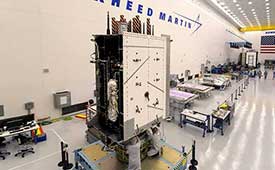
The United States Space Force’s GPS III program reached another milestone with the successful core mate of GPS III Space Vehicle 08 at Lockheed Martin’s GPS III Processing Facility in Waterton, Colorado, April 15.
With core mate complete, the space vehicle was named in honor of NASA trailblazer and “hidden figure” Katherine Johnson.
The two-day core mate consisted of using a 10-ton crane to lift and complete a 90-degree rotation of the satellite’s system module, and then slowly lowering the system module onto the satellite’s vertical propulsion core. The two mated major subsystems come together to form an assembled GPS III space vehicle.
Despite the COVID-19 pandemic, the Space and Missile Systems Center (SMC) and its mission partner Lockheed Martin ensured that SV08 core mate took place, in accordance with all Centers for Disease Control and local guidelines to minimize exposure or transmission of COVID-19. The GPS III Processing Facility’s cleanroom high bay was restricted to only key personnel directly supporting the operation.
“Core mate is the most critical of the GPS space vehicle single-line-flow operations,” said Lt. Col. Margaret Sullivan, program manager and materiel lead for the GPS III program. “Despite the restrictions presented by the COVID-19 pandemic, our team adapted and worked tirelessly to achieve this essential milestone.”
Katherine Johnson. (Photo: NASA)
Katherine Johnson. When the core mate operation is successfully completed, a GPS III satellite is said to be “born.” In keeping with the team’s tradition of naming GPS III satellites after famous explorers and pioneers, SV08 was named “Katherine Johnson” in honor of the trailblazing NASA mathematician and “human computer” who designed and computed orbital trajectories for NASA’s Mercury, Apollo and space shuttle missions.
One of four African-American women at the center of the nonfiction book by Margot Lee Shetterly and the movie Hidden Figures, Johnson was awarded the Presidential Medal of Freedom in 2015 for her groundbreaking contributions to the U.S. space program.
Other GPS III satellites have been named in honor of explorers including GPS III SV01 “Vespucci” after Amerigo Vespucci; GPS III SV02 “Magellan” after Ferdinand Magellan; and GPS III SV03 “Columbus” after Christopher Columbus.
Next up, performance tests. The next step for the newly christened “Katherine Johnson” is the post-mate Systems Performance Test (SPT) scheduled to begin in August. SPT electrically tests the performance of the satellite during the early phase of build and provides a baseline test data set to be compared to post-environmental test data.
GPS III SV08 is currently scheduled to launch in 2022.
The Mobile Service Tower rolls back from the ULA Delta IV rocket carrying the GPS III SV02 satellite in preparation for launch. (Photo: ULA)
GPS III is the most powerful GPS satellite ever developed. It is three times more accurate and provides up to eight times improved anti-jamming capability over previous GPS satellites on orbit. GPS III brings new capabilities to users as a fourth civilian signal (L1C), designed to enable interoperability between GPS and international satellite navigation systems, such as Europe’s Galileo system.
GPS III satellites will also bring the full capability of the Military Code (M-code) signal, increasing anti-jam resiliency in support of the warfighter. These continued improvements and advancements to the GPS system makes it the premier space-based provider of positioning, navigation, and timing services for more than four billion worldwide.
GPS III SV03 is scheduled to launch on June 30.. (Photo: Lockheed Martin)
GPS III SV03 to Launch June 30. Launched in December 2018 and August 2019, GPS III SV01 and SV02 became part of today’s operational constellation of 31 satellites, on January 13 and April 1, 2020 respectively. GPS III SV03 is scheduled to launch on June 30.
The SMC, located at the Los Angeles Air Force Base, California, is the center of excellence for acquiring and developing military space systems. Its portfolio includes the GPS, military satellite communications, defense meteorological satellites, space launch and range systems, satellite control networks, space based infrared systems, and space situational awareness capabilities.
Members of Congress were not pleased with the new U.S. Department of Homeland Security (DHS) report on positioning, navigation and timing (PNT), saying the long-delayed report contained numerous errors and failed to address many of the things Congress had required.
On the April 8, DHS submitted to Congress the brief, 26-page report on the nation’s PNT requirements. It took more than three years to produce and was delivered more than two years late.
In comparison, just two weeks earlier a team of eight British organizations sponsored by the European Space Agency (ESA) issued a 1,174-page report on the PNT needs of maritime commerce. The report from the Maritime Resilience and Integrity of Navigation (MarRINav) project was produced in less than a year.
House Transportation Committee Chair Peter DeFazio (D-OR), Armed Services Readiness Subcommittee Chair John Garamendi (D-CA) and Representative Alex Mooney (R-WV) expressed their disappointment this week in a letter to DHS Acting Secretary Chad Wolf. In addition to outlining their concerns, it asked that the report be retracted, rewritten and resubmitted within six months.
While the letter did not specifically mention the contrast between the DHS and British efforts, it did use the MarRINav report as a reference. And it was clear that the disparity in length and quality of the reports accentuated the disappointment for those who had hoped for a better product from DHS.
The letter asked that the report be retracted, rewritten and resubmitted within six months.
Factual errors
Factual errors in the DHS report, according to the letter, included getting the mandated timing for financial systems wrong, and mischaracterizing coverage areas and capabilities of various technologies including several that had been recently demonstrated for the Department of Transportation (DOT).
The letter also observed that DHS focused on commercial PNT users to the detriment of most Americans. It failed to consider the needs of public service organizations, governmental entities, and individual citizens in its analysis.
The lawmakers contend the report did not recognize that PNT provided by GPS is frequently a safety-of-life service and a public good that must be reinforced to protect economic vitality and national security.
Suspending operations, subscribing are flawed options
Two of the solutions to temporary GPS disruptions suggested in the DHS report are for users to suspend operations until the disruption is over, and to have purchased commercial PNT services as backups in advance of a disruption.
Suspending operations for emergency services and other critical functions is unacceptable, say the congressmen. And commercial PNT services to provide needed wide area PNT backups are not available.
Even if they were available, questions of affordability for the many non-profit and public entities that needed them, whether it would be more cost effective for the federal government to support such services, and similar issues would need to be addressed before the department could make a recommendation.
Suspending operations for emergency services and other critical functions is unacceptable.
No national backup
The letter also observed that the department has discounted the value of a national backup system, a position that seems to conflict with both longstanding and recent presidential policy. Having a backup for GPS has been policy since President Bush established the requirement in 2004. President Trump’s recent Responsible Use of PNT Executive Order called for a national research program on non-space-based PNT and “…mandates the Department of Commerce make available a GNSS independent source of Coordinated Universal Time for all users.”
DHS’ recommendation against a national backup also differs from the Europe/UK MarRINav report. In addition to calling for improvements to be made by commercial entities such as port and ship operators, MarRINav identifies the need for “terrestrial and sovereign” eLoran and VHF DES Ranging mode systems to support reliable maritime commerce. Establishing such systems will require support by the national government.
Most members of industry agree that some government involvement is needed. A CEO of one of the companies demonstrating its backup technology for DOT observed that the market would never solve the problem on its own.
“We have tried for 16 years to figure out a business case, and it’s just not there,” the CEO said. “GPS is too good and it’s free. You can’t compete with that. If America is going to have one or more new wide-area capabilities that most people can use — not just niche solutions for high-demand, well-heeled customers — the government is going to have to prime the pump.”
DHS did propose some efforts that resonated with the Congressmen, such as encouraging use of GPS receivers that resist spoofing and jamming. The lawmakers described these as “necessary but grossly insufficient” before requesting the report be withdrawn and redone.
DHS’ “Report on Positioning, Navigation, and Timing (PNT) Backup and Complementary Capabilities to the Global Positioning System (GPS)” is available here.
The letter from Congressmen DeFazio and Garamendi is available here.
The Maritime Resilience and Integrity of Navigation (MarRINav) project report is available here.
The U.S. Department of Homeland Security (DHS) issued a report on alternative sources of PNT on May 6. It was submitted to U.S. congressional committee leaders on April 8.
Section 1618 of the 2017 National Defense Authorization Act (NDAA) of Dec. 23, 2016, required the DHS to address the need for a GPS backup by identifying and assessing viable alternate technologies and systems.
The report is a summary and analysis of that assessment by the Homeland Security Operational Analysis Center (HSOAC) of PNT systems currently used by critical infrastructure. It also provides recommendations for the federal government’s next steps to increase the resilience of critical infrastructure to disruption of GPS services.
In the report, DHS offers the following recommendations to address the nation’s PNT requirements and backup or complementary capability gaps:
Temporary GPS disruptions: End users should be responsible for mitigating temporary GPS disruptions. For example, the Federal Aviation Administration maintains sufficient PNT capabilities to assure the continued safe operation of the national airspace, albeit at a reduced capacity, during GPS disruptions. The federal government can facilitate this mitigation for various critical infrastructure sectors, but should not be solely responsible for it.
PNT Diversity and Segmentation: The federal government should encourage adoption of multiple PNT sources, thus expanding the availability of PNT services based on market drivers. Encouraging critical infrastructure owners and operators to adopt multiple PNT systems will diffuse the risk currently concentrated in wide-area PNT services such as GPS. Federal actions should focus on facilitating the availability and adoption of PNT sources in the open market.
System Design: PNT provisioning systems, assets, and services must be designed with inherent security and resilience features. Critical infrastructure systems that use PNT services must be designed to operate through interference and to identify and respond to anomalous PNT inputs. These attributes are applicable to the PNT receivers and the systems that use them.
Pursue Innovation that Emphasizes Transition and Adoption: Incorporating PNT signal diversity into the PNT ecosystem should be pursued with an emphasis on research and development that prioritizes successful transition and adoption into existing GPS receivers, taking into account factors such as business case considerations, financial costs, technical integration, and logistical deployment.
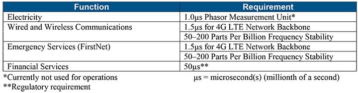
Table 1 shows timing requirements for critical infrastructure are, according to the report.
Table 1. (Image: DHS report)
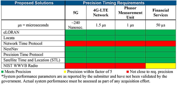
Table 2 from the report shows proposed timing solutions submitted by industry to DHS during a Request for Information (RFI) in December 2018. Systems that can meet or exceed timing requirements for critical infrastructure are indicated in green.
Table 2 (Image: DHS report)
Satelles responds
The Satelles company, which offers STL, issued a statement on the report. “This important report highlights the urgent need for GPS backup for critical applications, and it identifies and characterizes a variety of solutions that are available to meet this need today,” said Michael O’Connor, CEO of Satelles. “The report also describes the essential role of the federal government in urging industry to implement multiple technologies, without making the mistake of providing or selecting a single PNT solution.”
Continued O’Connor, “DHS goes on to define a baseline requirement for timing services accuracy for critical infrastructure. Not only does Satelles meet or exceed the precision timing specifications stated by DHS, but also our solution provides national coverage (including Alaska, Hawaii, and U.S. territories) and is commercially available now.”
Signing the letter were Senators Mike Lee, Brian Schatz, Ron Johnson, Edward Markey, Ted Cruz, Mark Warner, John Thune and Chris Coons. All except for Senator Coons serve on the Senate Committee on Commerce, Science and Transportation, which oversees the FCC. Senator Coons serves on the appropriations subcommittee that funds the FCC each year.
The letter referred to the hearing held by the Senate Armed Services Committee on the issue, and stated that only parties opposed to the FCC’s action were heard. The senators were concerned that the public also hear from the FCC.
Thirteen specific questions covered topics including:
How long the proceeding was on the docket
What notice given federal agencies of the proposed final order
Which agencies were consulted and how input was considered
The adequacy of the guard band and how the FCC has used the 1-db interference standard in the past
The 13th question asked the FCC why it believed granting the application was in the public interest.
A copy of the letter is available on the Resilient Navigation and Timing Foundation website.
In 2018 the first-ever European Radionavigation Plan said “It is recognized that [..] GNSS should not be the sole source of PNT information. Alternative PNT systems, not necessarily using radio frequencies, should thus be put in place where the criticality of the application requires it.”
Graphic from MarRINav report showing system of systems approach to PNT resilience and reliability. (Image: Resilient Navigation and Timing Foundation)
In 2019 the European Space Agency (ESA) published a permanent open call for proposals for positioning, navigation, and timing studies and systems, including those that had nothing to do with space.
“Maritime navigation and port operations are critical for almost every nation,” said Jonathan Turner, one of the MarRINav project team. “As an island nation with a strong maritime heritage, we in the United Kingdom perhaps have an even greater appreciation of this.” Turner is co-founder of the blue economy solutions company NLA International, which led a team of eight organizations cooperating on the project.
While MarRINav focused its analysis on the United Kingdom, the intent was to provide information, and an analysis framework, that could also be used by other nations.
Maritime is one of sectors most dependent upon GNSS, according to the project reports, and a sector with great awareness of GNSS vulnerabilities and their consequences. MarRINav concludes that integrity and resilience are two of the most important parameters for maritime navigation.
Maritime is also one of the sectors most ready to integrate space and terrestrial navigation systems, according to the report’s authors. The International Maritime Organization has already introduced a performance standard for a multi-system receiver, or MSR, that will incorporate a wide variety of navigation signals.
Despite the distractions of Brexit over the last four years, the United Kingdom has been particularly focused on its vulnerability to GNSS outages.
In February of this year the UK government announced it was establishing a virtual National Timing Centre to protect the nation from the risk of GNSS failure, and in March the final MarRINav report was published.
Among the project’s findings are that:
The United Kingdom needs a comprehensive maritime PNT architecture with multiple, diverse sources to ensure continuity of maritime operations
Such a “hybrid solution” could benefit other sectors, especially if non-maritime needs were considered early in the design
New PNT systems should be terrestrial and sovereign
Establishing such a system for the UK has a very positive benefit to cost ratio
Important aspects of the new architecture are E-GNSS (Galileo and EGNOS), Enhanced Loran (eLoran) and the Ranging Mode (R-Mode) of the VHF Data Exchange System (VDES), and complemented by the development of a specific Maritime Receiver Autonomous Integrity Monitoring (M-RAIM) algorithm.
LOCATA or a similar local positioning system should be implemented at UK ports to provide a backup for container operations.
Satelles Satellite Time and Location may have potential, but its utility has yet to be demonstrated for maritime.
Javad Ashjaee, founder of Javad GNSS, has died in Moscow, Russia. He died on May 30 after a three-week fight with COVID-19.
The news was first reported by a family member on social media. Ashjaee was born in 1949.
“It is with heavy hearts that we share the news of the passing of our founder Javad Ashjaee, a GPS/GNSS pioneer and visionary, on the morning of May 30, 2020, due to COVID-19 in Moscow, Russia,” reports a statement on the JAVAD GNSS website.
The website continues, “Over the course of 37 years, Javad made an incredible and far-reaching impact in the GNSS community. He pioneered the world’s most advanced GNSS technology through a multi-national effort that combined GPS and GLONASS and established more than a quarter century of partnership between Silicon Valley and Moscow. He was always proud of this ‘success story of cooperation.’ Javad was a true industry disrupter long before the term and concept became popular. His whole way of doing business was challenging and disrupting to the status quo.”
Read more about Ashjaee in his own words on the Javad GNSS website, where he describes the founding of his company:
“In 1998 I founded Javad Positioning Systems (JPS) and introduced Legacy, Odyssey and Regency products, followed by HiPer. It was a 76-channel geodetic receiver. Other companies later copied HiPer. Today, many of GNSS receivers look like it. I sold JPS to Topcon, who changed its name to Topcon Positioning System and is a very successful company.
“In 2007, after my obligations to Topcon ended and according to the provisions of our agreement, I founded Javad GNSS and introduced Triumph products. These were 216-channel receivers, integrated with several communication channels. We also introduced their Alpha, Delta, and Sigma versions. We were again the first to offer European Galileo and Japanese QZSS tracking in mass production. Triumph technology has been shown to have the best signal quality and best multipath reduction capabilities against all others tested by the German Aerospace. We also introduced GLONASS inter-channel (group/carrier delay) calibration to 0.2 millimeter which made GLONASS FDMA as good as GPS CDMA. Javad GNSS is growing fast and gaining market share.”
Articles, insight provided by Ashjaee to GPS World
Ashjaee’s nephew Sol Adibnejad provided this biography on his uncle via social media:
Javad was born in 1949 in Qom, Iran. After finishing his bachelor’s degree in electronic physics from the University of Teheran in Iran, he left Iran in 1972 to continue his education at the University of Iowa and got his graduate degrees, a doctorate in 1976. He went back to his native country Iran to teach at the university. He became the chairman of the Department of Computer Engineering at the Aryamehr University of Technology where he founded and managed a UNIVAC-100 computer centre. There, he created the first Iranian microprocessor lab. In 1978 he created one of the earliest student online and interactive registration systems in the world. In a few years and after the 1978 revolution and the political turmoil, things happened and he had to flee the country in 1981.
He went straight back to the U.S. and started the next chapter of his journey in life which led to the pioneering of GPS. He spent the rest of his life designing and manufacturing of many generations of his GPS and JPS products at JAVAD GNSS, JAVAD ArWest and JAVAD EMS in the Silicon Valley. Javad Ashjaee is listed as the primary inventor in 102 granted patents, the last one in April 2020.
Honeywell has been granted a four-year, $99 million contract to help the U.S. Air Force for the embedded GPS and inertial navigation systems (INS) modernization program (EGI-M). Honeywell will provide engineering, manufacturing and development services to the EGI-M program under the sole-source contract, according to the Department of Defense.
Work will be performed in Clearwater, Florida, through April 19, 2024.
The contract is the result of a sole-source acquisition and only one offer was received. The Air Force Life Cycle Management Center, Position, Navigation & Timing Contracting Branch, Robins Air Force Base, Georgia, is the contracting activity (FA8576-20-C-0001).
The COSMIC-1 program ended on May 1, when the last of six tiny satellites were decommissioned. The satellites were launched 14 years ago, and outlived their planned lifespan by 12 years.
COSMIC — the Constellation Observing System for Meteorology, Ionosphere and Climate (COSMIC) mission — uses GPS signals to provide a wealth of accurate atmospheric data and improve weather forecasts, according to Laura Snider, University Corporation for Atmospheric Research (UCAR), which ran the COSMIC program.
Meanwhile, the COSMIC-2 program (FORMOSAT-7 in Taiwan) continues. Its six satellites were launched on June 25, 2019, into low-inclination orbits. The mission was launched by NOAA as the agency’s first operational GNSS radio occultation mission.
COSMIC-1 demonstrated the value of GNSS radio occultation (GNSS-RO) to derive vertical atmospheric profiles of temperature, humidity and pressure by measuring the degree to which GPS signals bend as they travel through Earth’s atmosphere.
Weather centers used the high-quality, accurate data to improve forecasts; the data was also used by researchers.
“Throughout its lifetime, COSMIC-1 made an astounding 7 million vertical atmospheric profiles available to the operational forecast centers and research community,” writes Snider. “These data demonstrably boosted forecast accuracy and were referenced in more than 550 peer-reviewed scientific publications. In all, more than 5,000 users from over 100 countries have accessed COSMIC data.
COSMIC-1 was primarily funded by the National Space Organization in Taiwan, where the mission is called FORMOSAT-3. The leading U.S. sponsor on the project was the National Science Foundation. Other U.S. partners included NASA, the National Oceanic and Atmospheric Administration (NOAA), the Air Force and the Office of Naval Research.
UCAR also led the GPS/MET GPS radio occultation mission in the mid-1990s.
U.S. Federal Communications Commission (FCC) Chairman Ajit V. Pai has responded to a congressional letter expressing objections to the April 20 FCC decision to allow Ligado to establish a broadband network.
In a May 27 email sent to GPS World, the FCC wrote, “Given your interest in the Ligado order that the Commission adopted unanimously last month, we wanted to share with you the text of the letter Chairman Pai recently sent to members of Congress on this topic.”
The five-member FCC voted unanimously in April to approve an order to allow Ligado Networks to deploy a low-power nationwide 5G network. Experts and policy makers have said the broadband network could — or likely would — interfere with reception of GPS signals.
On May 7, a bipartisan group of 23 members of the House Armed Services Committee (HASC) sent a letter to the FCC questioning the decision, and this is the letter the FCC is now responding to.
The letter from Committee Chairman Adam Smith (D-Wash.) and Ranking Member Mac Thornberry (R-Texas) says the FCC order did not comply with Section 1698 of the National Defense Authorization Act for Fiscal Year 2017. That act prevents the commission from approving commercial terrestrial operations in certain portions of the L-band spectrum until 90 days after the commission resolves concerns of harmful interference to GPS devices.
The Senate Armed Services Committee held a hearing on the topic on May 6 with Department of Defense officials, and on May 15, 32 senators asked the FCC to address their concerns and stay the Ligado approval order while doing so.
“GPS has no right to operate in the spectrum in question, so there is nothing for Ligado to share.” — FCC Chairman Pai
The letter insists that GPS will remain protected. “Although your letter references the shared use of spectrum, the Commission’s L-band decision does not authorize any spectrum sharing between Ligado and GPS. In fact, spectrum in this band has been licensed to Ligado and predecessor companies for over 30 years — with those companies authorized to deploy terrestrially since 2004. And as mentioned above, one of the FCC’s conditions require separation of Ligado’s operations from GPS spectrum by means of a 23-megahertz guard band. Thus, any implication that the Commission has authorized Ligado to “share” spectrum that is currently allocated to GPS is incorrect. GPS has no right to operate in the spectrum in question, so there is nothing for Ligado to share.”
Download the full letter to Rep. Smith here. Download HASC letter to the FCC here.
The email to GPS World included the following statement: “The FCC is required by law to make its decision based on the facts in the record, and federal agencies, including the Department of Defense, were provided with multiple opportunities to put whatever facts they believed to be relevant into the record, including classified information, which the Commission has a process in place to protect.
“The Commission based its decision on all of the information in the record. Moreover, we are not aware of the FCC refusing any request by the Department of Defense to provide a briefing related to this matter.
“To the extent any federal agency opposed to the Ligado application chose not to share information with the Commission, that was the agency’s decision and suggests that it did not believe that the information in question would bolster its case.”
Spectrum regulation is much like land-use zoning: certain services are kept separate to avoid disturbing the neighbors. The U.S. Federal Communications Commission (FCC) has in effect allowed Ligado to build an outdoor concert venue next to a monastery, and by way of compensation, they offer free earplugs.
GPS/GNSS signals are extremely weak and the receivers are extremely sensitive. To give some perspective, by the time they get to the GPS receiver, GPS signals are about a factor of 20 less powerful than cosmic background noise. Ligado’s spectrum was licensed for mobile satellite services (MSS) and so was not likely to interfere with GPS.
“The U.S. Federal Communications Commission (FCC) has in effect allowed Ligado to build an outdoor concert venue next to a monastery, and by way of compensation, they offer free earplugs.”
With its new, and much more valuable license, Ligado now has a legal right to build a terrestrial cellular service. Exhaustive testing over the past 10 years has repeatedly demonstrated that such a system will interfere with high-precision GPS/GNSS receivers used in surveying, timing and Earth observation. The Department of Defense (DOD) has also made strong claims that such a system will cause harm to its systems. In all cases, the effect is much like riding a bicycle at night. You can see fine until someone comes around the corner with the high beams on and blinds you.
In its earlier filings, Ligado had asked for permission to transmit at a power level of 1500 Watts. In an amazing piece of legerdemain, they convinced the FCC, but not the Department of Transportation (DOT) or DOD, that by reducing transmit powers to 10 Watts, there would be no harm. This is a stunningly erroneous claim. As you lower the transmit power, you need many more cellular base stations to cover a given area. To use an analogy from my backyard, I can install one high-flow sprinkler head to cover the entire yard or a bunch of low-flow heads, each covering a small portion. Either way, the grass doesn’t care about anything other than inches of water, and I’m going to get wet if I run across the yard. Ligado’s core argument is equally wet. Nonetheless, it has great appeal to people who don’t understand how cellular systems work.
So, moving forward and assuming the license stands, interference events will become more prevalent and GPS will be deemed “less reliable.” Because interference sources are largely untraceable, blame will rarely attach to Ligado. I expect that GNSS receiver vendors will incorporate improved filters into receivers and pass the cost along to buyers. Ligado, or more likely whoever it sells the spectrum to, will quickly move to petition for increased transmit powers to lower capital costs; after all, more base stations cost more. And so, the Visigoths have arrived, 4G in hand with a 5G label.
Logan Scott is founder and owner of Logan Scott Consulting, www.gpsexpert.net.
CHC Navigation’s P5 geodetic GNSS receiver was successfully used by a Chinese team of surveyors to complete the 2020 Mount Everest Elevation Survey.
This is the first time that a team of Chinese surveyors has climbed the summit of Mount Everest, and it is also the first time that BeiDou-based Chinese GNSS receivers have been used to measure the height of Mount Everest, known in China as Mount Qomolangma.
China’s National Geodetic Survey Team and its Mountaineer’s Team used CHCNAV GNSS receivers. (Photo: CHC Navigation)
The Everest Project
To promote research on the Mount Everest elevation and to ensure the scientific character and accuracy of measurements, the Ministry of Natural Resources mobilized the Shaanxi Bureau of Topography and Geographic Information Mapping from the Chinese Academy of Topography and Mapping to plan and implement the measurements of the Mount Everest elevation. China’s National Geodetic Survey Team and its Mountaineer’s Team would undertake the arduous climb.
The plan set out the technical guidelines and required that the Everest Elevation Project be designed to achieve innovative and technological breakthroughs in several areas of research.
The first is to use the BeiDou satellite navigation system to perform GNSS measurements; the second is to use Chinese surveying and mapping equipment to complete the task.
Meeting Harsh Challenges
In October 2019, CHCNAV received a request from the Ministry of Natural Resources to provide GNSS equipment for the 2020 Everest Elevation Project. A dedicated team combining different departments, from R&D to manufacturing, was set up. The team elaborated the specific technical requirements from the National Survey engineers, in particular the difficulties and challenges related to the altitude of Everest.
Measuring the height of Mount Everest, especially the summit, is a challenge, not only for the limitation of the human body in such elevation environment, but also for the performance of the GNSS receiver itself.
At over 8,800 meters, the minimum temperature can reach -45°C and the atmospheric pressure is only 30 kPa (compared to the normal 101 kPa). All the surveying equipment used is exposed to both low temperature and low-pressure constraints.
In addition, the operation of the instruments must be as simple and reliable as possible in such an extreme environment. Surveyors wear thick winter clothing and lack oxygen, making every movement an extreme challenge. Finally, the measurement of the mountain peak must be completed at the first attempt, as re-measurement is impossible.
To meet these stringent requirements, CHCNAV has provided GNSS receivers that have passed the most rigorous environmental and reliability tests. The entire solution, from the GNSS receivers to the accessories, has been optimized to ensure mission success from the very beginning.
A wide temperature range of material — supporting an operating temperature range of –45°C to +85°C — were used, including redesigned lithium-ion batteries offering 12 hours of operation even at extremely low temperatures. Also used were antenna cables with a specific compound material to avoid any cracking or signal attenuation.
To ensure reliable operation of the receivers in a low-pressure environment, the GNSS receivers have built-in waterproof and breathable valves to maintain internal and external pressures. The low-pressure tests replicated a 25-kPa environment, corresponding to an altitude of 10,000 meters.
Additional ruggedized reinforcement prevented damage in the event of accidental receiver drop thanks to a robust design to keep the display and connectors safe. Following CHCNAV tests, third-party organizations were commissioned to perform environmental testing and reliability verification, including storage and operating at high/low temperatures, vibration, shock, rain, dust, humid heat, salt and fog.
From November 2019 to March 2020, CHCNAV’s GNSS equipment was supplied to the National Photoelectric Rangefinder Testing Center — under the requirements of the China Academy of Surveying and Mapping — for the most rigorous evaluation. As a result, the company’s GNSS receivers were selected to provide the peak altitude measurements of Everest in 2020.
The climb to the summit. (Photo: CHC Navigation)
Reaching the Summit
On April 5, 2020, at the Everest Elevation Survey Expedition Ceremony in Lhasa, CHCNAV officially donated GNSS equipment to the National Survey Team. Both product and technical training was provided to the team.
The 53 members of the first National Survey Team overcame the difficulties related to the environment, bad weather and the additional impact of COVID-19, and conducted a series of measurements on Mount Everest and surrounding areas such as level, gravity and GNSS.
Thirty of the 60 points of the GNSS control network were measured with CHCNAV GNSS receivers, including three of the seven Everest elevation intersection points.
On May 27, the CHCNAV GNSS receivers finally reached the summit and successfully completed the task.
The successful achievement of the Everest elevation measurement reflects the performance of the Chinese surveying and mapping industry, confirms BeiDou as a major part of the GNSS systems, and demonstrates the technical success of CHCNAV as a major player in the GNSS industry.
About CHC Navigation
Founded in 2003, CHC Navigation is a publicly listed company creating innovative GNSS navigation and positioning solutions. With a global presence across the world, distributors in more than 100 countries, and more than 1,300 employees, CHC Navigation is today recognized as one of the fastest-growing company in geomatics technologies.