By Peter Steigenberger, Steffen Thoelert, Oliver Montenbruck and Richard B. Langley
The first GPS III satellite, “Vespucci,” was launched in December 2018, started signal transmission in January 2020, and was set healthy later that month. The second GPS III satellite, nicknamed “Magellan,” was launched on Aug. 22, 2019, on a Delta IV rocket from Cape Canaveral, Florida.
Magellan, also identified by its space vehicle number (SVN) 75 (here referred to as GPS-75), started signal transmission with standard pseudorandom noise code (PRN) number 18 (here referred to as G18) on March 13. The L1 C/A, L1 P(Y), and L2 P(Y) signals were activated at 17:16:30 GPS Time (GPST), while the L1C, L2C and L5 signals followed less than two hours after Vespucci’s launch at 18:59:30 GPST. Transmission of navigation messages started at 19:00:00 GPST with GPS-75 (G18) marked as unhealthy.
PRN G18 was previously used by the 27-year-old Block IIA satellite GPS-34 that had been already removed from the active GPS constellation on Oct. 7, 2019, but continued signal transmission until March 9, 2020. GPS-75 is already being tracked by a large number of tracking stations of the International GNSS Service (IGS). Based on the data collected by these stations, the Center for Orbit Determination in Europe (CODE), headquartered in Bern, Switzerland, has been providing precise orbit and clock products for this satellite since March 14.
A comparison we performed with the CODE precise orbit products revealed initial broadcast ephemeris errors of up to 100 meters (3D) and an orbit-related signal-in-space range error (SISRE) of about 13 meters. Within four days, a SISRE (orbit component) of 24 centimeters was achieved, which closely matches the performance of the rest of the GPS constellation.
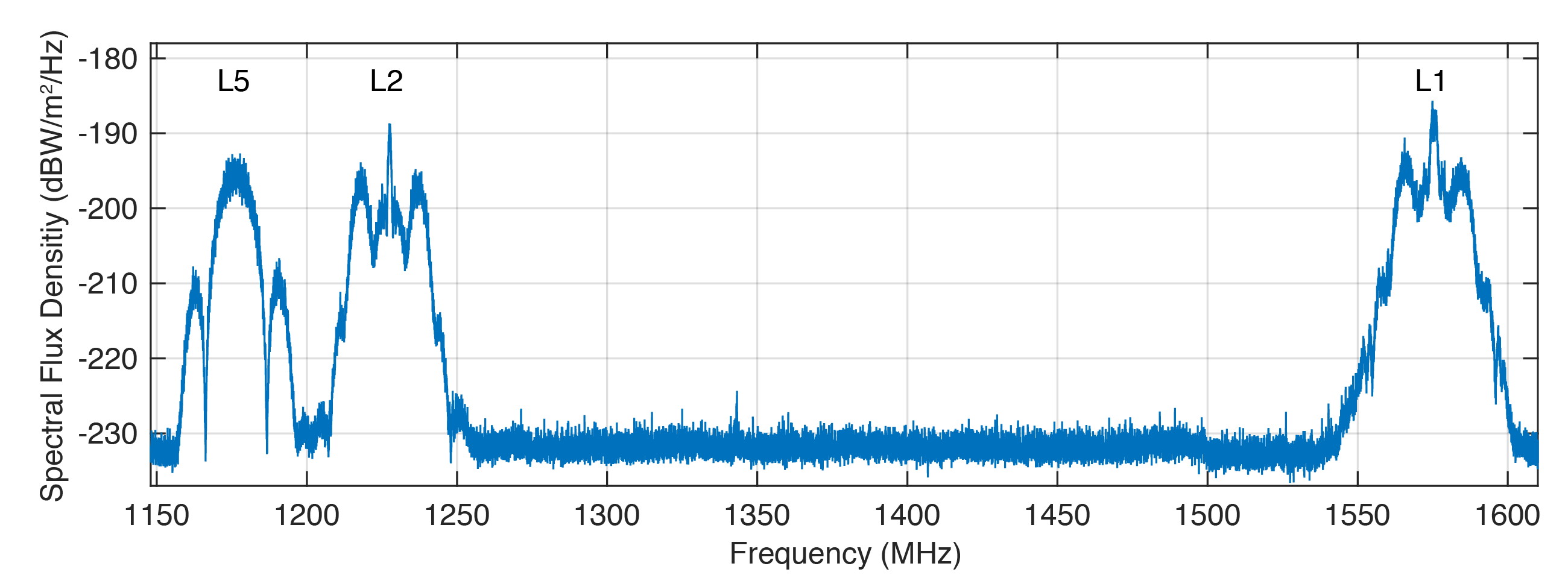
Figure 1 shows the spectral flux density of GPS-75 in the L1, L2 and L5 frequency bands obtained with the 30-meter high-gain antenna of the German Aerospace Center (DLR) located in Weilheim, Germany. The civil L1 C/A, L1C and L2C signals can be identified as sharp peaks in the center of the respective frequency bands.
FIGURE 1. Spectral flux density of GPS-75 measured with DLR’s 30-meter high-gain antenna. (Figure: Steigenberger, et al)
The prominent side lobes in the L1 and L2 bands are associated with the military M-code. The wide main lobe of the L5 signal with two smaller and sharper side lobes is caused by the superposition of two in-phase and quadrature signals with a 10-MHz binary phase-shift keying (BPSK) modulation. We found that all signals are in good shape and have a quality similar to that of the first GPS III satellite.
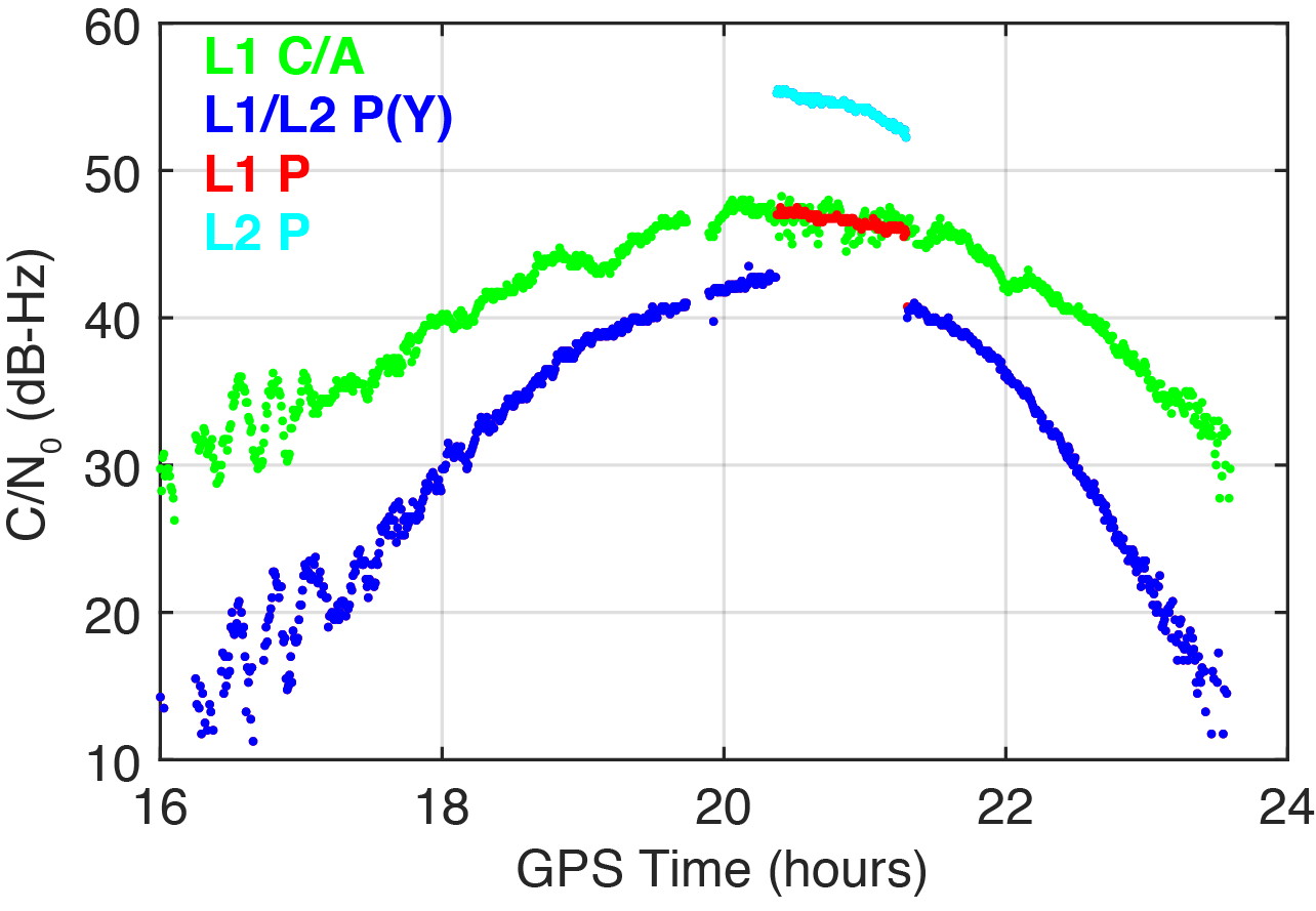
On March 16, 2020, we detected a significant change in the carrier-to-noise-density ratio of the L1 and L2 P(Y)-code signals. Figure 2 illustrates these changes for the IGS station located in Patumwan, Thailand (CUSV00THA). The L1 and L2 P-code signals are usually encrypted with the W-code to prevent spoofing (the generation of fake signals by adverse parties). The resulting encrypted signals are denoted by P(Y). Geodetic GNSS receivers are capable of tracking the P(Y) signals with a semi-codeless approach.
FIGURE 2. Carrier-to-noise-density ratio (C/N0) of the second GPS III satellite, GPS-75, tracked by the IGS station CUSV00THA in Patumwan, Thailand, on March 16, 2020. Between 20:22 and 21:18 GPST, unencrypted P-code signals were tracked. (Figure: Steigenberger, et al)
As a result, C/N0 of L1 P(Y) and L2 P(Y) are virtually identical and significantly smaller than the C/N0 of the unencrypted signals due to losses of the semi-codeless tracking technique. This can be seen in the blue-colored plot of Figure 2, where the C/N0 values of L1 P(Y) and L2 P(Y) are identical and smaller by 4.5–16 dB compared to L1 C/A depending on the elevation angle of the satellite.
However, between 20:22 and 21:18 GPST, an increase of the P-code C/N0 values was observed. The values changed by 4.5 and 12.5 dB for L1 and L2, respectively. This change is an indicator that unencrypted P-code signals were transmitted, rather than encrypted ones. This assumption can be verified by the “Anti-Spoof Flag” given as the 19th bit of the handover word (HOW) of the GPS LNAV navigation message.
Indeed, decoding of the raw navigation data from the IGS station CHOF00JPN in Chofu, Japan, showed that the Anti-Spoof Flag indicated a deactivation of anti-spoofing between 20:22:00 and 21:17:48 GPST and verified our assumption that unencrypted P-code signals were transmitted during that time period.
It has to be noted that only Javad receivers within the global multi-GNSS network of the IGS show this increase in C/N0. Other receiver types report continuous C/N0 values for the P-code signals, indicating that a semi-codeless tracking technique was continuously applied irrespective of the Anti-Spoof Flag.
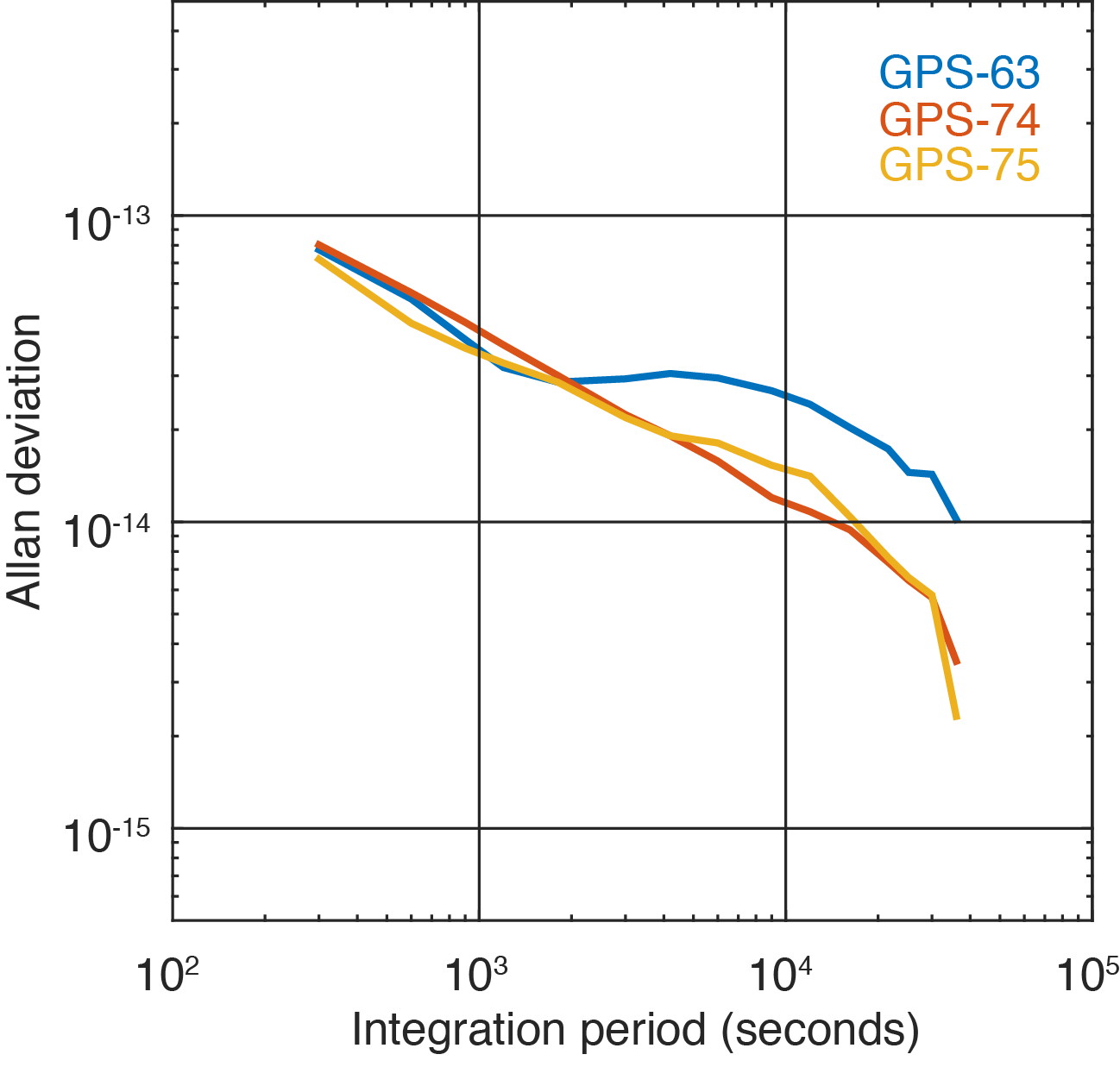
Figure 3 shows the two GPS III satellites’ Allan deviation, which measures the clock stability achieved in orbit; that is, the average frequency error over different time scales. In addition, the Block IIF satellite GPS-63 is shown, which is in the same orbital plane as GPS-75.
FIGURE 3. Allan deviation of the Block IIF satellite GPS-63 and the GPS III satellites GPS-74 and GPS-75 computed from 5-minute clock solutions produced by DLR. (Figure: Steigenberger, et al)
For integration times up to 2,000 seconds, the clock stability of GPS-75 is slightly better compared to the first GPS III satellite, GPS-74, but the situation is opposite for integration times larger than 5,000 seconds. The latter finding might be caused by the fact that GPS-75, unhealthy at the time, was tracked by a smaller number of stations compared to the healthy GPS-74.
As a consequence, the observed Allan deviation may partly be contaminated by orbit determination errors. In any case, both GPS III satellites clearly outperform the Block IIF satellite GPS-63 that suffers from thermal line bias variations visible as an increased Allan deviation starting at an integration time of about 2,000 seconds.
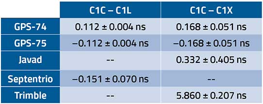
The activation of the second GPS III satellite transmitting the new civil L1C signal enables the estimation of differential code biases (DCBs) between, for example, the L1 C/A signal (Receiver Independent Exchange [RINEX] format observation code C1C) and different tracking modes of the L1C signal. Septentrio receivers track only the pilot component of the L1C signal (C1L), whereas Javad and Trimble receivers perform a combined data+pilot tracking (C1X).
DCBs are estimated from pseudorange (code) observations of a global tracking network and are corrected for ionospheric delays obtained from global ionosphere maps. The DCB estimates shown in Table 1 are based on eight days of data from 10 Javad, 21 Septentrio and 3 Trimble receivers.
TABLE 1. Differential code bias estimates in nanoseconds between L1 C/A and L1C for the GPS III satellites and average receiver DCBs. (Data: Steigenberger, et al)
As we have applied a zero-sum condition for the estimation of satellite DCBs of just two satellites, the values of GPS-74 and GPS-75 obtained from the same type of L1C observables differ only by the sign. The DCBs estimated from different L1C observables, namely C1L and C1X, differ by 56 picoseconds, corresponding to a range difference of 1.7 centimeters. The receiver DCBs are quite homogeneous for receivers from each manufacturer but differ by up to 6 nanoseconds between various manufacturers.
On April 1, 2020, GPS-75 was set healthy and joined the constellation of operational GPS satellites. The third GPS III satellite, named “Columbus,” was shipped to the Cape Canaveral launch site in February 2020. Its launch is expected no earlier than June 30, 2020, and at least two GPS III launches per year are planned for the near future.
Equipment. Measurements reported in this article were collected with JAVAD GNSS TRE_G3TH and TRE_3, Septentrio PolaRx5 and Trimble Alloy multi-GNSS, multi-frequency receivers. The spectral overview was captured with a Rohde & Schwarz EM100 digital compact receiver.
PETER STEIGENBERGER and OLIVER MONTENBRUCK are scientists at the German Space Operations Center of the German Aerospace Center (DLR). STEFFEN THOELERT is an electrical engineer at DLR’s Institute of Communications and Navigation. RICHARD B. LANGLEY is a professor at the University of New Brunswick and editor of the “Innovation” column for GPS World magazine.
Further Reading
“Optimum Semicodeless Carrier-Phase Tracking of L2” by K.T. Woo in Navigation, Vol. 47, No. 2, 2000, pp. 82-99, doi: 10.1002/j.2161-4296.2000.tb00204.x.
Interface Specification IS-GPS-200K: NAVSTAR GPS Space Segment/User Segment Interfaces by Global Positioning Systems Directorate Systems Engineering & Integration, Los Angeles Air Force Base, El Segundo, California, March 4, 2019. Available online: https://www.gps.gov/technical/icwg/IS-GPS-200K.pdf
“Apparent Clock Variations of the Block IIF-1 (SVN62) GPS Satellite“ by O. Montenbruck, U. Hugentobler, E. Dach, P. Steigenberger and A. Hauschild in GPS Solutions, Vol. 16, No.3, 2012, pp. 303-313, doi: 10.1007/s10291-011-0232-x.
“Differential Code Bias Estimation Using Multi-GNSS Observations and Global Ionosphere Maps” by O. Montenbruck, A. Hauschild and P. Steigenberger in Navigation, 2014, Vol. 61, No. 3, 2014, pp. 191-201, doi: 10.1002/navi.64
SUGUS — a European Commission project to promote European GNSS services for the integration of drones into the airspace — is conducting an online survey of stakeholders.
SUGUS, the European Commission’s project for the development of European GNSS (Galileo and EGNOS) services for U-space, is carrying out a survey to identify, gather and understand stakeholders’ needs, and to improve user experience of E-GNSS in complex operations and built-up areas.
U-space is a set of new services and specific procedures designed to support safe, efficient and secure access to European airspace for large numbers of drones.
SUGUS members invite all the stakeholders to take part in the survey, including suppliers of U-space services, manufacturers of unmanned aerial systems (UAS) platforms and GNSS receivers, UAS pilots and operators, public bodies, authorities and organizations, and centers for UAS testing and training.
The survey will be available until May 15.
The survey results will be used as a valuable input to tailor the E-GNSS Service Provision layer to specific drone missions’ needs, allowing a better mitigation of risks in complex operations like BVLOS (beyond visual line of sight) and UAM (urban air mobility), increasing safety and security.
Also, the points of view collected will help to define the requirements and then the implementation of a new E-GNSS-based API which will deliver live and forecast information about performance, coverage, alerts to users and more.
The API will be called upon by UTM service providers, UAS designers or UAS systems developers, and integrated in existing commercial solutions.
“The survey organized by SUGUS is a key element for E-GNSS Programs to capture user requirements of the drone community,” explained Miguel Aguilera, European Commission advisor. “The results will be used to enhance EGNOS and Galileo Service Provision targeting drone operations, increasing safety and security, and facilitating a swift and efficient deployment of U-space.”
SUGUS Project
SUGUS (Solution for E-GNSS U-Space Service) is a European Commission’s project to promote European GNSS services (EGNOS and Galileo) for the drone market and for the effective and safe integration of these aerial platforms in the airspace.
It is a European Union H2020 R&D project to be carried out by GMV (main contractor) with everis Aerospace, Defense and Security as co-leaders of a consortium also involving VVA Brussels, ESSP, FADA-CATEC and Unifly.
SUGUS will help to develop services geared towards the effective integration of drones into the airspace. A series of trials will be held to show the benefits of E-GNSS for drone operators, as well as its approval by aviation authorities.
“Celebrating this anniversary gives us a moment to recognize how far we’ve come, but also to get pumped about what lies ahead for our program and our role in executing that.”
By First Lieutenant Tyler Whiting Peterson Air Force Base, Colorado
The Global Positioning System marked its 25th year of operation on April 27.
On this date in 1995, the system reached full operational capability, meaning the system met all performance requirements. U.S. Air Force Space Command formally announced the milestone three months later.
“This is a major milestone,” Gen. Thomas S. Moorman Jr., former Air Force Vice Chief of Staff, said in 1995. “GPS has become integral to our warfighters and is rapidly becoming a true utility in the civilian community.”
Initially developed for the military to meet a critical need for determining precise location on the battlefield, GPS has also become an integral part of technology affecting the lives of billions of people worldwide.
“The United States Space Force’s continuing objective for the constellation is to ensure GPS remains the Gold Standard for global space-based positioning, navigation and timing,” said Gen. Jay Raymond, USSF Chief of Space Operations, and U.S. Space Command Commander.
Image: USAF
Today, the U.S. Space Force operates the GPS satellite constellation as a global utility – always available to everyone, everywhere on Earth.
“GPS is a free for use service provided by the Space Force that enhances everyday lives around the world,” said Brig. Gen. DeAnna Burt, USSF Director of Operations and Communications. “GPS provides the highest accuracy positioning and timing data. In addition to the essential capabilities it provides for the military, GPS underpins critical financial, transportation and agricultural infrastructure. It’s always available, whether for an ATM transaction or securing a rideshare.”
Military capabilities
Its military capabilities first enhanced combat operations in 1990 and 1991 during Operations Desert Shield and Desert Storm. Allied troops relied heavily on the new GPS signal to navigate the featureless deserts in Kuwait and Iraq.
In the early 2000s, during Operations Enduring Freedom and Iraqi Freedom, GPS contribution to warfighting increased significantly. For example, the GPS constellation enabled accurate munitions, allowing the delivery of GPS-aided Joint Direct Attack Munitions with pinpoint precision and minimal collateral damage.
Today, in addition to these and other GPS-enabled warfighting capabilities, Airmen conduct resupply missions with battlefield precision airdrops to combat forces with GPS-guided, parachute-delivered equipment pallets known as “Smart Pallets.”
Continually updated
The GPS operational constellation currently has 31 satellites, and the system is continually updated and modernized, making it a resilient system to maintain the signals required for accurate positioning, navigation and timing around the world.
The first satellite of the new GPS III version, called Vespucci, was launched into space Dec. 23, 2018.
The 2nd Space Operations Squadron at Schriever Air Force Base, Colo., operates GPS. The squadron recently accepted control of the second GPS III satellite, called Magellan, on March 27.
GPS III is meeting users’ emerging needs and responding to tomorrow’s threats with improved safety, signal integrity and accuracy. GPS III satellites are more accurate, have improved anti-jamming capabilities, and have doubled the design life; when compared to previous iterations of GPS. They are also designed to incorporate new technology and changing mission needs,
“The 25th Anniversary is a huge, momentous occasion for us. We take great pride in providing this global utility to the approximately six billion users worldwide,” said Lt. Col. Stephen Toth, 2nd SOPS commander. “Celebrating this anniversary gives us a moment to recognize how far we’ve come, but also to get pumped about what lies ahead for our program and our role in executing that.”
Leaders in the GNSS/PNT community are reacting to the Federal Communications Commission (FCC) decision to approve an order to allow Ligado Networks to deploy a low-power nationwide 5G network. The departments of Defense and Transportation have criticized the decision, concerned about interference with GPS signals.
Below are statements we have received from our readers.
Logan Scott, LS Consulting
Logan Scott
Spectrum regulation is much like land use zoning in that certain services are kept separate so as to avoid disturbing the neighbors. The FCC has in effect allowed Ligado to build an outdoor concert venue next to a monastery and by way of compensation, they offer free earplugs. GPS / GNSS signals are extremely weak and the receivers are extremely sensitive. To give some perspective, by the time they get to the GPS receiver, GPS signals are about a factor of 20 less powerful than cosmic background noise. Ligado’s spectrum is/was licensed for mobile satellite services (MSS) and so was not likely to interfere with GPS.
With their new, and much more valuable license, Ligado now has a legal right to build a terrestrial cellular service. Exhaustive testing over the last 10 years has repeatedly demonstrated that such a system will interfere with high precision GPS/GNSS receivers used in surveying, timing, and earth observation. The DoD has also made strong claims that such a system will cause harm to their systems. In all cases, the effect is much like riding a bicycle at night. You can see fine until someone comes around the corner with the high beams on and blinds you.
The FCC has in effect allowed Ligado to build an outdoor concert venue next to a monastery and by way of compensation, they offer free earplugs.
In their earlier filings, Ligado had asked for permission to transmit at a power level of 1500 Watts. In an amazing piece of legerdemain, they convinced the FCC, but not the DoT or DoD, that by reducing transmit powers to 10 Watts, there would be no harm. This is a stunningly erroneous claim. As you lower the transmit power, you need many more cellular basestations to cover a given area. To use an analogy from my backyard, I can install one high flow sprinkler head to cover the entire yard or a bunch of low flow heads, each covering a small portion. Either way, the grass doesn’t care about anything other than inches of water and I’m gonna get wet if I run across the yard. Ligado’s core argument is equally wet. Nonetheless, it has great appeal to people who don’t understand how cellular systems work.
So, moving forward and assuming the license stands, interference events will become more prevalent and GPS will be deemed “less reliable”. Because interference sources are largely untraceable, blame will rarely attach to Ligado. I expect that GNSS receiver vendors will incorporate improved filters into receivers and pass the cost along to buyers. Ligado, or more likely whoever they sell the spectrum to, will quickly move to petition for increase transmit powers so as to lower capital costs; after all more basestations cost more. And so, the Visogoths have arrived, 4G in hand with a 5G label.
John Fischer, Orolia
John Fisher. (Photo: Orolia)
At Orolia, we support the position of the DOT, DHS and DOD and the measures they are taking to protect the GNSS band. However, interference is a fact of life in this band as the GNSS signals are very weak, so additional measures must be taken for resiliency, especially for critical infrastructure. Adversarial interference is much worse than this, so a range of solutions are possible: from the simple – for example, a horizon blocking antenna that shields energy from a nearby tower – to full multi-layer defenses that include RF filtering, advanced DSP filtering/detection, alternative PNT from STL signals, atomic clock and IMU backup, and CRPA antennas. No one solution covers every case, but the problem can be managed.
Mitch Narins, Strategic Synergies
Mitch Narins
It is quite concerning when a panel of lawyers makes a decision, despite the results of years and years of studies, and over the objections of our nation’s technical and operational Position, Navigation and Timing (PNT) experts. While I have championed the need for a complementary and resilient PNT system for many, many years, one cannot dispute the worldwide benefits that GPS and other GNSS have brought — from safety, security, and economic perspectives.
As noted in the FCC’s press release, “The order also requires Ligado to protect adjacent band incumbents by reporting its base station locations and technical operating parameters to potentially affected government and industry stakeholders prior to commencing operations, continuously monitoring the transmit power of its base station sites, and complying with procedures and actions for responding to credible reports of interference, including rapid shutdown of operations where warranted.” I believe that it is imperative that GPS users, both within the Government and in the private sector, understand:
How base station location information will be disseminated, what power levels and radiation patterns will be utilized, and what recourse GPS users will have to object to the proposed location and service;
How the service will be monitored for each base station location, what systems will be used to do the monitoring, and how the monitoring information will be publicly disseminated;
How reports of interference will be filed, how and by whom they will be determined to be “credible”, how and in what timeframe will a “rapid shutdown of operations” be accomplished, and how appropriate mitigations will be identified and implemented; and
Given the importance and concern associated with this action, what special oversight mechanisms, involving civilian and military participants, should be put in place to avert potential safety, security, and economic impacts to our nation’s critical infrastructure.
While one can model, and even test problems based on the location of facilities where aircraft would be expected to be operating close to the ground (e.g., airports and heliports), one can never be sure where a medevac or other first responder helicopter may have to set down in response to an accident or incident site. In keeping with the FCC’s own press release, it is unclear how a pilot experiencing problems with GPS (if, in fact the pilot could recognize such a problem) would be able to report the issue and have it mitigated in real time to support a safety or security mission — unless all areas around all ground transmitters were mapped and first responders could request specific ones to be turned off when operations were expected in a known area. Unfortunately, the limits of these operating areas are, many times, unknown or rapidly changing (e.g., forest fires) and any delay in reaction to unforeseen events could prove detrimental to safety, security, and economic wellbeing.
Mitre conducted a test wherein small Unmanned Aerial Systems (sUAS) could detect and avoid an aircraft based on receipt of its ADS-B squits. Perhaps these ground transmitters should include ADS-B receivers and automatically go off-air if a helicopter comes within a certain distance. I have no doubt that Ligado would not appreciate this solution …
I would hope that those who disagree with this decision will seek out a means to correct this through either the legislative or judicial branches or both. Personally, I cannot see how this either “promotes the general welfare” or “provides for the common defense” (I didn’t have to go to law school to come to those conclusions). I also believe that (1) the ever growing importance and criticality of PNT services should provoke the Congress to modify the makeup of the FCC to include PNT expertise at the very top; and (2) the FCC Office of Chief Engineer needs to become an independent point of expertise akin to the Office of Inspector General to preclude undue pressure and potential political “bending” of technical analyses.
Finally, regardless of whether one agrees or disagrees with the FCC’s order, no one can possibly believe that this decade-long tale of woe is an example of governmental “best practice.” As it took the energy and significant resources from so many more important PNT initiatives, I hope that a quality/leadership body (perhaps GAO and/or a group of IGs) take up the task to do an independent “lessons learned” assessment of this decade-long tale of woe needs to be carefully examined, as it took the energy and significant resources from so many more important PNT initiatives — we should never have to go through this ever again.
Mitch Narins is the principal consultant and owner of Strategic Synergies, LLC, a technical and management consulting firm that he formed after retiring following over four decades of U.S. government service with the FCC, US Navy/Marine Corps, and the Federal Aviation Administration.
Alison Brown
Allison Brown
GPS user equipment needs to be designed to be more resilient to interference. The threat to GPS has been well understood for many years but agencies and vendors have been slow to respond to improve national resiliency against jamming threats. The President signed into law the National GPS Timing Resilience and Security Act in 2018 and on 2/12/2020 signed an Executive Order on Strengthening National Resilience through Responsible Use of Positioning, Navigation, and Timing Services recognizing “the disruption or manipulation of these services has the potential to adversely affect the national and economic security of the United States.” The onus is now on vendors and agencies to develop resilient solutions that can operate in the presence of intentional and unintentional interference. These solutions would also mitigate any potential impact from the use of adjacent bands by operators such as Ligado to deploy 5G and Internet of Things services.
Ellen Hall
Ellen Hall
Overall, the GPS industry should be encouraged to do more to protect themselves from harmful interference. While it is too late for today’s receivers, the next generation needs to introduce more resilience. I agree with the House Armed Services Committee Chairman in saying, “While I strongly support development of the world’s most robust, safe and secure network, using L-band spectrum in such close proximity to critical GPS, as Ligado’s proposal requires, carries an unacceptable risk….”
The FCC said the approval order included stringent conditions aimed at ensuring that GPS would be vulnerable to harmful interference. It seems the only way to prevent harmful interference, would be to permanently fund an oversight commission to monitor Ligado’s system. I believe only Congress can appropriate funding for this effort, therefore the FCC’s decision should be a recommendation to Congress to implement. It is not enough to leave it to a five-person committee to “encourage” that “stringent conditions” are implemented. Enforcement is crucial. Critical infrastructure should be regulated to ensure that we can cope better with “noisy neighbors.”
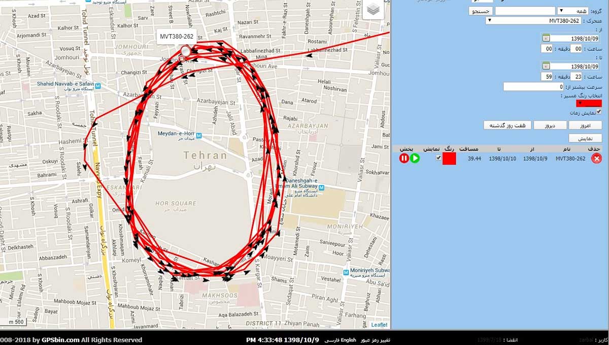
In March, the U.S. government received an unusual inquiry about GPS disruptions. It was from a user in Iran reporting what appeared to be “circle spoofing” — a phenomenon that had only previously been observed in China.
“Some of GPS devices received fake signal and show the fake valid location. Yesterday I test a device, it can get signal and give real position. After 10 minutes the device show moving around a big circle in tehran by 35 km/h speed. I can’t fix this problem by restarting the device.
“The GPS module time is correct but the location is not. I attach Excel file of data and map of the track. I can’t get any response from Communications Regulatory Authority (CRA) of The I.R. of Iran. Do you know about this?”
Here is one of the images provided by the reporting source:
GPS spoofing device in operation at Iran’s Army Command and Staff College. (Screenshot courtesy of Dana Goward)
A little internet research showed that the spoofing was taking place at or near Iran’s “AJA University of Command and Staff,” formerly called the “War University.” It is the staff college for Iran’s Army.
Reports to the U.S. government about GPS disruption are normally listed on the U.S. Coast Guard’s Navigation Center website. This one has not been posted. Coast Guard officials said that it is because the report was received by another agency and did not contain sufficient information. Attempts by Coast Guard personnel to contact the reporting source for more information to enable the report to be posted were unsuccessful.
GPS spoofing is often easiest to detect in maritime areas. Ship automatic identification system (AIS) transmissions include location data and are detected by satellite. The data is then aggregated and used by various companies for a number of applications. Viewing ship location reports over time has revealed thousands of ship receivers spoofed to airports in Russia, and hundreds spoofed into circles (presumably around the spoofing device) in China.
Clearly, though, any system that aggregates and displays GPS location data can help detect wide area spoofing activity.
Strava is a mobile app for runners and cyclists. The company aggregates location data and displays it on a heat map to highlight athletes’ favorite routes.
The Strava heat map for Tehran shows that circle spoofing has also been employed in at least one other location. The below screenshot shows GPS-enabled fitness trackers circling a government complex that houses offices for several defense and technology-related organizations.
This heat map shows GPS spoofing at a government complex in Tehran,which houses the Ministry of Defense, Communication Regulatory Authority, Telecommunications Infrastructure Company, and Ministry of Telecommunications and Technology. (Screenshot: courtesy of Dana Goward)
Iran was the first nation to publicly announce it had the ability to spoof GPS signals and seems to have used it to great advantage.
In 2011, a CIA drone that had been operating across the border in Afghanistan landed at an Iranian airfield. Iran’s government claimed that its forces had sent false signals to the drone’s GPS receiver in order to capture it.
At first, U.S. government officials said that this kind of spoofing was not possible. Several months later, Prof. Todd Humphreys demonstrated how it could be done to a drone at the University of Texas football stadium.
U.S. officials then admitted that spoofing was possible, but said it wasn’t what happened to the CIA drone. At the same time, they offered no alternate explanation of how the drone was captured.
In 2016 Iranian forces captured two U.S. Navy boats that had strayed into Iran’s territorial waters. This was just after President Obama had succeeded in pressing that nation to give up nuclear weapons research, and was on the same day as Obama’s last State of the Union address. There was little reason for the U.S. Navy boats to have veered so far off course, and it was clear that the Iranian Navy was waiting for them.
Many speculated that Iran had spoofed GPS signals to lure the U.S. Navy boats into Iranian waters. U.S. officials have denied that this was the cause of the incident, but have not publicly offered an alternate explanation other than “mis-navigation.”
During heightened tensions in the Persian Gulf in 2019, Iran shot down a U.S. surveillance drone and President Trump seemed ready to launch a retaliatory strike. This was called off at the last minute. According to some reports, the strike was canceled because of the likelihood the drone was in Iranian airspace at the time.
At about the same time British intelligence was warning merchant vessels in the area that Iran was attempting to use GPS spoofing to lure them into Iranian waters as a pretext for seizing the ships.
While the Middle East has been a hotbed of jamming and conventional spoofing for years, these recent circle-spoofing incidents are the first of the kind we know of in the region. It may well be that Iranian forces have recently received equipment from China and are experimenting with it. They could also be using it to deter GPS guided drones and disrupt other surveillance systems in the vicinity of sensitive government facilities.
The U.S. Air Force has released the 5th Edition of the GPS Standard Positioning System (SPS) Performance Standard (PS), according to U.S. Coast Guard Navigation Center (NAVCEN) Civil GPS Service Interface Committee (CGSIC).
With final signature by the U.S. Department of Defense, the standard was cleared for public release on April 16. This is the first update to the SPS PS since 2008 and, for the first time, includes pre-Initial Operating Capability (IOC) performance standards for new civil GPS signals L2C and L5, in addition to L1 C/A.
The SPS PS specifies the levels of SPS performance in terms of broadcast signal parameters and GPS constellation design. According to NAVCEN, the U.S. government is committed to meeting and exceeding the minimum levels of service specified in the SPS PS.
The five-member Federal Communications Commission (FCC) voted unanimously to approve an order to allow Ligado Networks to deploy a low-power nationwide 5G network.
The approval comes despite objections from the U.S. Defense Department (DOD), other federal agencies and major U.S. airlines, all of whom are concerned about near-band interference with GPS.
The FCC said the approval order included stringent conditions aimed at ensuring GPS would not experience harmful interference.
“After many years of consideration, it is time for the FCC to make a decision and bring this proceeding to a close,” said FCC Chairman Ajit Pai in an April 16 news release. “We have compiled an extensive record, which confirms that it is in the public interest to grant Ligado’s application while imposing stringent conditions to prevent harmful interference.”
Ligado is seeking to repurpose a swath of L-band spectrum for a 5G network focused mainly on connecting smart devices and other internet-of-things services. According to the FCC, the order will “promote more efficient and effective use of our nation’s spectrum resources and ensure that adjacent band operations, including the Global Positioning System (GPS), are protected from harmful interference.”
In response, members of both the Senate and House Armed Services Committees and other defense advocates are considering legislative action to overturn the order.
Two areas that rely heavily on the integrity of GPS signals include defense and transportation. The DOD issued a joint statement with the Department of Transportation (DOT) criticizing the FCC ruling.
“Americans rely on our Global Positioning System (GPS) each day for many things: to locate citizens in need of emergency assistance through our E-911 system, to secure our financial system, to order and receive shipments, to travel by car for work and leisure, to facilitate commercial trucking and construction work, and even to make a simple cellphone call. Our departments rely on GPS each day for all those reasons as well to coordinate tactical national security operations, launch spacecraft, track threats, and facilitate travel by air and sea. The proposed Ligado decision by the Federal Communications Commission will put all these uses of GPS at risk.”
House Armed Services Committee Chairman Adam Smith (D-Wash.) released a letter he sent to Defense Secretary Mark Esper and FCC Chairman Ajit Pai raising concerns about Ligado’s 5G network.
“While the United States must be a leader in the implementation of 5G networks, our creation of these networks must not hamper our military’s operational capacity in any way. China’s aggressive, global promotion of its 5G companies presents a considerable security challenge that must be addressed. However, Ligado’s proposal, which seeks a portion of spectrum adjacent to that used for Global Positioning Systems, poses an even larger security risk.
“The Department of Defense has been clear and direct: providing this license to Ligado would cause unacceptable operational impacts and adversely affect the military’s use of GPS. The military’s seamless use of GPS is vital to our national security. Our service members rely on GPS satellites for critical precision timing and navigation, and thousands of weapons systems are embedded with GPS signals.
“While I strongly support development of the world’s most robust, safe and secure network, using L-band spectrum in such close proximity to critical GPS, as Ligado’s proposal requires, carries an unacceptable risk that far outweighs the possibility of a 5G network.”
‘Risk of crippling’ GPS
Defense Secretary Mark Esper said via Twitter on Friday that the “Ligado proposal would needlessly imperil GPS-dependent national security capabilities. The Department continues to support domestic 5G options, but not at the risk of crippling our GPS networks. Nearly a dozen other federal agencies have joined us in opposing this proposal.”
“Although I appreciate the concerns that have been raised by certain Executive Branch agencies, it is the Commission’s duty to make an independent determination based on sound engineering. And based on the painstaking technical analysis done by our expert staff, I am convinced that the conditions outlined in this draft order would permit Ligado to move forward without causing harmful interference. For example, the draft order would authorize downlink operations at a power level that represents a greater than 99% reduction from what Ligado proposed in its 2015 application.”
Image: A-Digit/DigitalVision Vectors/Getty Images
The release also provided this background about the Ligado proposal, and the “conditions” under which the FCC decided to approve it.
In recent years, Ligado has amended its application to significantly reduce the power levels of its base stations from 32 dBW to 9.8 dBW (a reduction of 99.3%). Ligado has also committed to providing a significant (23 megahertz) guard-band using its own licensed spectrum to further separate its terrestrial base station transmissions from neighboring operations in the Radionavigation-Satellite Service allocation. As such, Ligado is now only seeking terrestrial use of the 1526-1536 MHz, 1627.5-1637.5 MHz, and 1646.5-1656.5 MHz bands. The Order is conditioned to reflect these technical requirements. It also requires Ligado to protect adjacent band incumbents by reporting its base station locations and technical operating parameters to potentially affected government and industry stakeholders prior to commencing operations, continuously monitoring the transmit power of its base station sites, and complying with procedures and actions for responding to credible reports of interference, including rapid shutdown of operations where warranted.
However, The decision “appears to ignore the well-documented views of the expert agencies charged with preserving the integrity of GPS, specifically on the critical issue of what constitutes harmful interference to users of Global Navigation Satellite Systems (GNSS),” said J. David Grossman, executive director of the GPS Innovation Alliance (GPSIA). He continued,
J. David Grossman
“GPSIA has consistently advocated for adoption of the 1-dB Standard as the only reliable mechanism that provides the predictability and certainty to ensure the continuation of the GPS success story, with the support of the Department of Defense, the Department of Transportation and numerous other federal agencies. The 1-dB Standard for radiofrequency-based services is critical for GNSS. The FCC’s press release refers to conditions placed on Ligado’s application to prevent harmful interference, and GPSIA and its members intend to carefully review the details of today’s order while continuing to vigorously advocate for promoting, protecting and enhancing GPS.”
Ligado Networks President and CEO Doug Smith issued this statement in reaction to the approval.
“Ligado thanks the Commissioners for moving promptly to approve the order regarding our applications. We greatly appreciate their unanimous support as well as the expert engineering analysis determining that a terrestrial network can be deployed in the L-band to advance our country’s economic and security interests while fully protecting GPS. Our spectrum can be very instrumental in the transition to 5G, and we look forward to utilizing satellite and terrestrial services to deploy customized private networks and deliver innovative, next-generation IoT solutions for the industrial sector.”
Positive reactions to the decision
On April 20, the FCC released a compilation of responses to the decision, all of them in support.
Attorney General Bill Barr: “I applaud FCC Chairman Pai’s proposal to make available L-band spectrum, to be used together with C-band spectrum, for deployment of advanced wireless services, including 5G. As I said in my speech at the Center for Strategic and International Studies, swift FCC action on spectrum is imperative to allow for the deployment of 5G. This is essential if we are to keep our economic and technological leadership and avoid forfeiting it to Communist China.” (Statement, 4/16/2020)
Secretary of State Mike Pompeo: “I commend Federal Communications Commission (FCC) Chairman Pai’s draft order that would release the L-Band spectrum. Quick action on this order, in conjunction with the allocation of a portion of the C-Band for 5G, is vital to our national security and will help ensure that the United States is the global leader in advanced technologies such as AI, the Internet of Things, edge computing, and the next generation of telemedicine. Accelerating the deployment of 5G is essential to our country’s growth, and global economic security.” (Statement, 4/16/2020)
Sen. Ron Johnson (WI): “In a time when connectivity is and will continue to be more important than ever, it’s great to see @AjitPaiFCC move forward with freeing up critical spectrum resources for #5G.” (Tweet, 4/16/2020)
Sen. Mark Warner (VA): “As the U.S. works to lead the world in 5G innovation and promote wider high-speed internet coverage, it’s all the more important to put our valuable mid-band spectrum to use. I urge the @FCC to follow the Chairman’s lead and approve Virginia-based @LigadoInsights’s application.” (Tweet, 4/16/2020)
Rep. Billy Long (MO): “I applaud @AjitPaiFCC and the @FCC for taking action to unlock vital L-band spectrum that has been held hostage by bureaucratic slow-walking for far too long. Jobs and 5G is a win-win for the country.” (Tweet, 4/16/2020)
Rep. Doris Matsui (CA): “I called on the @FCC to move forward with new, innovative uses of L-band spectrum to advance 5G. Glad to see the Commission take action on this front today to encourage efficient use of our spectrum.” (Tweet, 4/16/2020)
Former Rep. Bob Barr (GA): “Federal Communications Commission Chairman Ajit Pai’s decision to circulate a draft FCC Order would at long last move forward the process of opening up a segment of mid-band satellite spectrum for commercial use in 5G technology deserves praise. … If adopted by the five-member Commission headed by Pai, the draft Order would tangibly signal to the country and the world that the United States is committed to seize the leadership in deployment of 5G technology, a role China openly covets.” (Statement, 4/16/2020)
American Action Forum: “More good news from the FCC! 5G is incredibly important and this is yet another example of actions that will enable innovation in 5G and support the growing number of connected devices.” (Tweet, 4/16/2020)
American Enterprise Institute Visiting Scholar Mark Jamison: “@FCC approval of Ligado petition should accelerate 5G, bring diversity to marketplace, and increase efficient spectrum use. … Good leadership and bipartisan effort!” (Tweet, 4/20/20)
American Enterprise Institute Visiting Scholar Roslyn Layton: “Kudos @AjitPaiFCC for unlocking more vital mid-band spectrum for #5G. Record of 10 years shows @LigadoNetworks took many steps with agencies and firms to address potential issues with GPS. We must move quickly on 5G!” (Tweet, 4/16/2020)
Citizens Against Government Waste: “The FCC has the engineering expertise to determine the best use of this spectrum and whether alternative uses would cause undue interference. The adoption of the Chairman’s draft order will promote 5G and IoT development, while providing the necessary safeguards for services using adjacent bands, including GPS positioning. … The L-band would not be used at all for the foreseeable future unless the FCC takes action. Freeing up the spectrum requested by Ligado will not only expand the use of 5G, it will also help to prevent other countries, particularly China, from getting ahead of the U.S. in 5G deployment.” (Blog, 4/17/2020)
Competitive Carriers Association: “[We] commend Chairman Pai for circulating a draft order to approve Ligado’s applications, which will make much-needed mid-band spectrum, specifically L-band spectrum, available for terrestrial use. This long-awaited, positive progress comes at a critical time for all Americans, particularly those in rural areas, who are relying on mobile connections and services more than ever before. Mid-band spectrum provides real opportunities for deploying next-generation technologies, and competitive carriers are eager to access this valuable resource to expand and enhance their networks.” (Statement, 4/16/20)
Competitive Enterprise Institute: “Access to spectrum is crucial for our modern economy, connecting everything from radios, to cellphones, to satellites. But for too long, turf-wars between federal regulatory agencies have left spectrum bands largely unavailable for valuable commercial applications. Today’s FCC decision wrests spectrum away from bureaucratic waste and delivers it into the hands of people who will aide our economic recovery and resiliency in the aftermath of the COVID-19 pandemic.” (Statement, 4/16/2020)
CTIA—The Wireless Association: “We’re pleased to see that the FCC has managed to cut through the red tape to make a decision on Ligado. This multi-year process reveals the challenges at play in our nation’s spectrum policy and the need for stronger support for new commercial wireless services. We need to all learn lessons from this process and ensure that decisions on key spectrum bands like lower 3 GHz occur in a more expedited and collaborative manner.” (Statement, 4/16/2020)
FreedomWorks: “Freeing up broadband spectrum will make America a global technological leader and will lead to innovations and developments that will improve quality of life across the country. Chairman Pai and the FCC should be applauded for their work resolving these matters[.]” (Blog, 4/15/2020)
Free State Foundation: “Chairman @AjitPaiFCC has made a commendable decision to act on @LigadoNetworks’ proposal to put L-band spectrum into use for next-gen wireless services. This move takes seriously the @FCC’s responsibility and the urgent need for more commercial spectrum.” (Tweet, 4/16/2020)
Georgetown Law Institute for Technology Law & Policy Distinguished Fellow Gigi Sohn: “This decision was a long time coming, but it’s the right one. … Kudos to @AjitPaiFCC for having the fortitude to move this forward.” (Tweet, 4/16/2020)
Information Technology & Innovation Foundation: “Great to see @FCC taking steps to finally approve @LigadoNetworks waiver for terrestrial use of their spectrum. This will be a boon to industrial IoT connectivity, bringing more productivity, safety, and resiliency for users of the network.” (Tweet, 4/16/2020)
International Center for Law & Economics: “Promoting deployment of 5G & next-gen IoT devices means finding new ways for incumbents to responsibly operate in ever-closer proximity. The @FCC’s Ligado order does that. Credit to @AjitPaiFCC for finding a way fwd that promotes innovation while limiting the risk of interference.” (Tweet, 4/16/2020)
Lincoln Network: “Access to spectrum is an essential feature in any working 5G plan. Frankly, one key barrier in opening up this vital resource is government’s stronghold on ‘beachfront’ spectrum whether they own it or not. … This proceeding has been in regulatory limbo for several years due in large part to government stakeholders’ speculative interference claims regarding GPS-applications. … The FCC’s draft order in this proceeding provides enough protection for incumbents in adjacent bands, adds more competition into the 5G-IoT space, and allows consumers to have more access to broadband. Everybody wins.” (Blog, 4/16/2020)
Mercatus Center Senior Fellow Brent Skorup: “Too often new tech is stalled by FCC regulation and incumbents. Chairman Pai pledged to breathe new life into Sec. 7. It’s great to see Chairman Pai and the FCC act on that pledge, liberalize spectrum, and expedite the deployment of new wireless services.” (Tweet, 4/16/2020)
National Security Institute: “Big move by @FCC Chairman @AjitPaiFCC today to support US 5G availability. This is a key nat sec issue w/ threat posed by China + econ benefits of broad 5G deployment in US.” (Tweet, 4/16/2020)
New America Foundation’s Open Technology Institute: “Kudos to @AjitPaiFCC @FCC for again standing up to Fed agencies trying to hoard spectrum they are not using – or, in this case, which is licensed to @LigadoNetworks! A big plus for #5G wireless ecosystem if it’s built out.” (Tweet, 4/16/2020)
R Street Institute: “If you can change your business model to be more productive and profitable, without hurting anyone else, then regulations shouldn’t stand in your way. Well done, @FCC!” (Tweet, 4/16/2020)
Progressive Policy Institute: “We applaud the FCC’s ongoing efforts to accelerate the deployment of 5G. Repurposing this commercial spectrum for a mobile broadband network is another step in the right direction.” (Tweet, 4/16/2020)
Public Knowledge: “The Chairman’s proposed Order reveals how the FCC has worked to both protect incumbent GPS users while allowing for pro-competitive commercial licensing of spectrum. … Congress has entrusted the FCC to strike the proper balance between the needs of incumbents and the potential benefits to new entrants or new users, and here, the FCC gets it right. In approving Ligado’s license, the FCC has taken an important step forward in its role as the sole arbiter of spectrum disputes and, in this instance, has correctly sided on behalf of the public interest to help deliver the potential of 5G to more Americans.” (Statement, 4/16/2020)
Technology Policy Institute: “Allowing the Ligado spectrum to lie fallow would represent a waste of valuable resources that could provide substantial benefits for consumers in the form of new Internet of Things and other uses. … Failure to approve the Ligado license modifications would have the opposite effect, transferring a large block of spectrum from the commercial sector back to the government. The Commission’s action today will avoid that outcome.” (Statement, 4/16/2020)
Wireless Infrastructure Association: “WIA applauds Chairman Pai for circulating a draft order to approve Ligado’s plans to deploy a nationwide network that would primarily support 5G and IoT services. After years of diligence, study, and discussion, today’s action is further evidence that the FCC bases its decisions on science and engineering. Freeing up more spectrum, especially mid-band spectrum, is vital to 5G deployment. Ligado’s proposal offers an enormous opportunity for infrastructure investment, deployment, and connectivity for Americans across the country right when we need it most.” (Statement, 4/16/2020)
With the rise in public unrest from COVID-19 and increasing numbers of remote operations, the susceptibility and vulnerability of a cyber attack has never been greater.
On a regular basis, we hear intelligence experts proselytize an eventual cyber doomsday where our critical infrastructure (CI) — communications systems, information technology (IT) capabilities and financial networks — are compromised or disabled. These kinds of attacks could devastate our national and economic security and even disrupt basic day-to-day activities like turning on lights or buying groceries with a debit card. Even worse, a significant cyber event could escalate to the point of military actions between nation-states.
In 2012, Defense Secretary Leon Panetta warned about a potential “Cyber Pearl Harbor.” These threats were echoed by then head of Cyber Command, Gen. Keith Alexander, with hope the public, private and CI sectors would take notice of the broad, detrimental impacts of cyber threats.
Geoff Hella, Centauri Corp.
In kind, the Obama administration took aggressive steps to protect CI networks, and the Trump White House followed suit by enacting measures to strengthen the resilience of other technologies integral to our CI.
The latest White House Executive Order specifically addresses our reliance on position, navigation and timing (PNT) services and directs agencies to work in close coordination with the private sector to identify, secure and continue to improve the resilience of these technologies.
PNT services, such as GPS, are an extension of our IT systems, but despite this, PNT has been a relatively invisible utility and is oftentimes unknowingly utilized by most CI owners and operators. In the coming years, our reliance on PNT will only increase, making now a critical time to foster close collaboration between public and private sectors and determine which systems, networks and assets are dependent on PNT services. Identifying these dependencies will allow us to verify appropriate resilient PNT services being used, determine downstream effects of the disruption and manipulation of PNT services, and manage the associated risks to dependent systems.
The new directive is fast paced — outlined in 90-, 180- and 360-day increments — and instructs agencies to utilize existing public-private sector cybersecurity and CI information sharing relationships, such as Sector Specific Agencies (SSA), to share threat data, educate stakeholders and promote a responsible use of PNT.
What’s the rush?
So, why is this happening right now? PNT systems are crucial to American life, and successfully securing them requires a coordinated response and sooner rather than later. In fact, malicious nation-states, such as Russia, are spreading their wings into new threat vectors to inflict damage and are shifting their attention to PNT.
Because of these risks, we must do more as a country to establish safeguards around these technologies. That being said, agencies and organizations cannot expect their current workforce to become PNT security experts overnight. Rather, business owners and operators would be better served bringing in third-party experts that have been building security into PNT even prior to this directive.
These private-sector partners can map out a systematic approach to prioritize PNT security in a three-step plan:
Find. Identify PNT systems and “profile” them — establish point A.
Fix. Find and correct vulnerabilities — many can be non-material/tactics, technique and procedures (TTP) solutions.
Fortify. Develop TTPs, timelines and guidance for users to upgrade CI where needed — the path to Point B.
When PNT services were first developed, the systems could be openly used by anyone and security was not built into the original PNT architecture — similar to when the internet was created. This has made it easy for adoption into almost everyday life and revolutionized the world. Likewise, it has also made it easy for bad actors to access and compromise it, forcing the country to scramble, backtrack and implement cybersecurity best practices.
The good news is that we aren’t completely starting from scratch. The Department of Defense has been working to secure its PNT systems and will be updating its processes and practices as part of the recent White House directive.
The security community can also look to best practices in assessing risk of vital systems and model PNT security measures on existing guidelines such as Federal Information Processing Standards (FIPS) and NIST Special Publication 800 Series.
Path Forward
Per the Executive Order, lead agencies such as the Department of Transportation and the Department of Commerce will work in concert with the private sector to define “PNT profiles” and share these attributes with stakeholders. The coalition of partners will then be able to account for where and how PNT is used by CI owners and operators and will promote the responsible use of PNT services moving forward.
Beyond defining PNT profiles, the EO allocates new research and development funding for Commerce to develop an alternative to GNSS, which provides real-time PNT data to planes, trains, ships and automobiles that transport vital goods and resources — all in an effort to reduce the level of acceptable risk.
The White House also requires the public and private sectors to develop vulnerability testing and incident response plans and, simultaneously, encourage the private sector to use and develop more robust PNT services in anticipation of new Federal Acquisition Regulatory Council (FARC) contract requirements.
While these changes may seem like a fast moving and overwhelming process, there are many cases where CI owners and operators will not be required to integrate material solutions, but rather procedural training and behavioral adjustments. The information sharing processes already exist to provide improved situational awareness, coordination among the public and private sectors, increased reporting, solidified baseline risk assessments and a broader understanding of how systems rely on PNT. The challenge is facilitating widespread adoption across all stakeholders, increasing collaboration and education among and across the CI groups.
For this effort to be successful, it will require a whole-community, multi-pronged approach to operating in a new “threat top-of-mind” paradigm that is grounded on cross-sector information sharing, training and education. Both public and private sectors should also outsource expertise and leverage existing models like the DoD PNT doctrine, NIST standards and incident response capabilities.
Gregory Gerten is director of PNT Operations at Centauri, supporting the PNT enterprise through innovative use of modeling and simulation, hardware-in-the-loop and field testing, and process automation. He earned his master’s degree in electrical engineering from the University of Dayton, and has completed post-graduate courses in GPS from the Air Force Institute of Technology. He has more than 20 years of experience in system design, development and integration in the areas of communications, navigation, electronic warfare tactics and weapon systems.
Geoffrey Hella is a senior engineer for Centauri assigned to a Space Command contract through the Joint Navigation Warfare Center (JNWC). He has worked to achieve a Master of Aeronautical Science (MAS) from Embry-Riddle Aeronautical University in 1994. During his 40 years of experience, he has been a leader in product development and system design to successfully carry out a vast range of assignments in multiple engineering disciplines. His assignments include: aircrew member of the United States Air force (USAF); National Air Space (NAS) engineer for the Federal Aviation Administration (FAA); Special Nuclear testing and safeguards engineer for the Department of Energy/Sandia National Laboratories; and Supervisory Control and Data Acquisition (SCADA) engineer for both public and private Industry, electric and gas utility companies. Hella currently holds a six-sigma certification and a general radio operator license from the Federal Communication Commission (FCC) and a remote pilot operator certificate from the Federal Aviation Administration (FAA).
The 2020 Galileo Masters are open for submissions. The competition is designed to award applications, services and new ideas that use Galileo and EGNOS, in synergy with other space programs, to respond to pressing needs facing business and society.
The 2020 competition has three European GNSS Agency (GSA) challenges, themed “Space for Future Generations.”
The first challenge, the “Space for our Planet Challenge,” aims to tackle climate change and environmental degradation. Services based on data from Galileo, EGNOS and Copernicus Earth observation can be used to mitigate this threat by supporting more environmentally-conscious life choices, resulting in a healthier planet, GSA said.
The second challenge, the “Space for Being Safe and Healthy Challenge,” seeks out solutions that use downstream space data provided by Galileo, EGNOS and/or Copernicus as key enablers of innovative applications to help stem the spread of COVID-19 pandemic.
The third challenge, the “Space for Fun Challenge,” targets solutions using data from Galileo and EGNOS in the gaming, sports, leisure and tourism markets, where GNSS enables the monitoring of user performance and helps make augmented reality games even more immersive.
For all three challenges, there is a cash price of 10,000€, with another 10,000€ awarded to the overall Galileo Masters 2020 winner.
Registration is free, and entries must be submitted by June 30.
The United States Space Force’s Space and Missile Systems Center (SMC) has decided to reschedule the launch of GPS III SV03 (GPS III-3) from Cape Canaveral Air Force Station to minimize the potential of COVID-19 exposure to the launch crew and early-orbit operators.
Originally scheduled for late April, the launch is now projected for no earlier than June 30, pending a reevaluation in May.
“We do not make this decision lightly, however, given our GPS constellation remains strong, we have the opportunity to make a deliberate decision to maintain our mission assurance posture, without introducing additional health risk to personnel or mission risk to the launch,” said Lt. Gen. John F. Thompson, SMC commander and program executive officer for space.
The Lockheed Martin-built GPS III satellite will be the second GPS satellite launched on a SpaceX Falcon 9 rocket. It will be the first National Security Space Launch mission where SpaceX will attempt to recover the booster, reports Space News.
GPS III-3 brings the third modernized GPS III satellite to the operational GPS mission, and the team remains ready to execute. GPS III will bring three times better accuracy and up to eight times improved anti-jamming capability than its predecessor.
The current constellation is healthy with 31 satellites on orbit, allowing the team to take this strategic pause without gaps in coverage or capability.
“The GPS system supports vital U.S. and allied operations worldwide, unabated. As the COVID-19 pandemic is a threat to national security, likewise, rescheduling the launch is in the interest of national security,” said Gen. Thompson. “We have to get it right the first time, and protecting our people is just as important as cost, schedule, and performance.”
SMC still plans to complete the next three GPS launches this year. The team is taking the necessary steps to protect the health of personnel to allow a swift return to the mission.
“Some of the steps include procedural and facility modifications at the GPS III Launch and Checkout Capability (LCC) operations center and reducing the onsite crew size to provide adequate physical distancing, per CDC guidelines,” said Col. Edward Byrne, chief of Medium Earth Orbit Space Systems Division. “Once these efforts are completed, and the crews have rehearsed and are deemed proficient and ready to execute under these modified conditions, we fully intend to return to our launch cadence for deploying GPS III satellites.”
A leader of GPS III acquisition, SMC’s Production Corps is the United States Space Force’s acquisition office for producing and delivering GPS satellites, ground systems and military user equipment. The Production Corps’ agile program management techniques, smart business approach and close teaming with Lockheed Martin Space are enabling the production and delivery of GPS III’s new civil and warfighting capabilities by 2023. GPS delivers the “gold standard” of space-based positioning, navigation, and timing services vital to U.S. and allied operations worldwide, and underpins critical financial, transportation, and agricultural infrastructure that more than four billion users have come to depend on daily.
SMC’s Launch Enterprise, located at Los Angeles Air Force Base, California, is responsible for the acquisition and operation of launch vehicles, which includes mission assurance and launch safety. The Launch Enterprise is also responsible for leading the effort to certify new entrants to provide launch services for National Security payloads.
GPS III SV03 will be launched into operational orbit by a SpaceX Falcon 9 rocket. GPS III SV03 will be the second National Security Space Launch (NSSL) mission to be launched on a SpaceX Falcon 9 rocket and the first NSSL mission where a Launch Service Provider is recovering a booster.
The Space and Missile Systems Center is the U.S. Space Force’s center of excellence for acquiring and developing military space systems. SMC’s portfolio includes space launch, global positioning, military space vehicle communications, defense meteorological space vehicles, range systems, space vehicle control networks, space-based infrared systems, and space situational awareness capabilities.
SMC continues to deliver vital capabilities to the warfighter and the world, despite the challenges of COVID-19. Recent examples include the successful launch of AEHF-6 on March 26, Operational Acceptance of GPS III SV02 by Space Operations Command on March 27, and the inclusion of SV02 into the operational GPS constellation on April 1.
SpaceX’s Falcon 9 rocket orbited the first GPS III satellite on Dec. 23, 2018. (Photo: SpaceX)
The PNT Coffee Talk event will be held online and is open to those interested in learning more and discussing this national priority from the industry and government perspectives.
The Executive Order, issued Feb. 12, is a federal initiative to protect critical infrastructure from GPS/GNSS jamming and spoofing threats, and other disruptions to critical PNT services. These threats can deny access to, or compromise, essential PNT data that critical infrastructure needs to operate.
This initiative, titled “Executive Order on Strengthening National Resilience through Responsible Use of Positioning, Navigation and Timing Services,” includes the following critical infrastructure: defense, homeland security, transportation, power grids, communications/mobile, precision agriculture, weather forecasting and emergency response.
Key actions include assessing jamming, spoofing and other PNT disruption risks across these critical infrastructure programs, developing customized PNT profiles to address risks, and deploying Resilient PNT technology to increase resilience.
Survey seeks feedback. Orolia asks those interested to share questions and comments and let the company know what you’d like to discuss during this PNT Coffee Talk event through an anonymous survey.
Despite the worldwide COVID-19 response, the 50th Space Wing at Schriever Air Force Base continues to execute its critical operations, while ensuring the proper steps are taken to maintain airmen’s health and well-being.
As of March 20, there are no confirmed cases of COVID-19 at the base. The 50th Space Wing commander, Col. James E. Smith, has enacted multiple safety measures — social distancing, minimum manning and temperature checks at restricted area portals — to protect Airmen and the base’s critical operations.
No pandemic in space
Airman 1st Class Brice Brewington, 4th Space Operations Squadron, is an extremely high-frequency satellite systems operator.
“It’s critical we continue the mission during trying times,” Brewington said. “Although there is a pandemic here on Earth, there’s no pandemic in space and our adversaries aren’t going to stop trying to gain superiority from us any time soon. We need to stay mission-ready rain, sleet, snow, hail and even during a pandemic to complete our mission at the most elite level possible.”
To minimize transmission, 4th SOPS Airmen use cleaning wipes and sanitation spray to clean their workstations. Additionally, accountability is taken daily to make certain the squadron’s airmen are feeling healthy and well.
“I know the service I help provide is critical for [service members] down range,” Brewington said. “I take my job very seriously. Lives depend on it, and we can’t let a pandemic slow down our operations.”
2 SOPS at their stations
The 2nd Space Operations Squadron is one of the United States Space Force’s premier units. 2 SOPS operates the GPS mission, providing a global utility to Earth’s population for free.
“No matter what, we need to ensure this mission continues so the American people and the world know they can depend on us to be the gold standard in precision, navigation and timing,” said Lt. Col Stephen Toth, 2nd SOPS commander.
Some of the services that use GPS to operate are ambulances, hospitals, police departments and fire departments.
“It would make a global pandemic that much worse if we were to go down,” Toth said. “It could prevent a lot of the day-to-day things we rely on from happening, it could be catastrophic.”
According to a study conducted by U.S. Department of Transportation on the economic impact of GPS, a 30 day outage could range from a 2.7 to 5.5 billion dollar economic loss. Additionally, GPS supports 14 of 16 essential industries in the U.S.
“We’ll remain reliable no matter what the condition the world is in,” Toth said. “Whether it be a pandemic, hurricane, tornado or any other type of crisis, we have plans and training for whatever threat we may face so the mission doesn’t stop.”
Unlike other jobs across the Department of Defense, those directly conducting operations can’t telework. They need to be in a sensitive compartmented information facility or restricted area in a secured area to perform the mission. Airmen can access specific terminals and networks only accessible on the operations floor.
“The American people can count on space and they can count on our military to continue to provide the level of capability that’s expected no matter what’s going on in the world,” Toth said. “In times of crisis, people shouldn’t have to question whether we’ll be here or not, because we will and the mission won’t stop.”
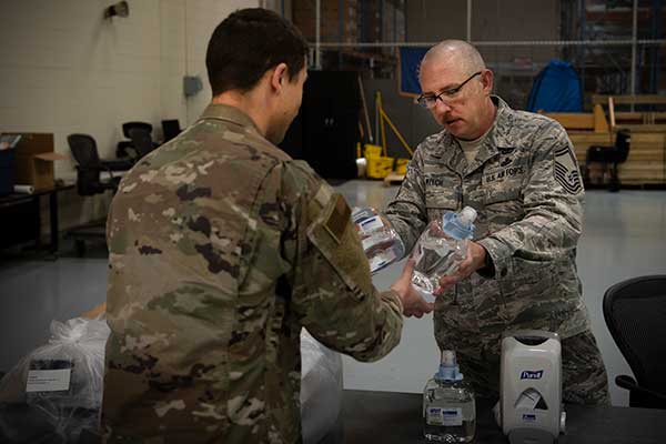
Senior Master Sgt. Michael Welch, 50th Contracting Squadron superintendent, distributes sanitizer to an Airman at the 50th Logistics Readiness Flight warehouse at Schriever Air Force Base, Colorado, April 2, 2020. The 50th CONS secured sanitizing supplies to units across the base to prevent Airmen from contracting COVID-19. (Photo: U.S. Air Force / Airman 1st Class Jonathan Whitely)
Rapid response and decontamination
The 50th Space Wing stood up the Rapid Response Decontamination Detail in response to COVID-19 and hosted a training session March 26 in the wing headquarters building. The training highlighted the importance of having a crew on standby to keep the mission essential operations centers clean and functioning.
“It’s a 24/7 team trained and equipped for rapid response to support operations inside the restricted area,” said Capt. James Selix, 3rd Space Experimentation Squadron weapons officer and R2D2 officer in charge.
For operations crews to request R2D2 services, a squadron commander must call the team and they have 15-30 minutes to respond and initiate the cleaning operation.
“We’re expecting airmen do the preventative portion of their cleaning,” Selix said. “We’re not there to do it for them. We are activated when there are folks showing symptoms of COVID-19 or have positive tests.”
The crew has a priority system should they need to deconflict requests.
“We want to be rapid to support operations,” Selix said. “[Airmen] are continuing their missions 24/7 and if their crews are doing deep cleanings, that’s pulling them away from doing supports, contacting satellites or protecting the restricted area.”
The detail will be operating in eight-hour shifts to ensure their 24/7 availability. They will be on standby to provide terminal cleanings and supplies to squadrons as needed.
“This is a new enemy,” Selix said. “This is a new fight for all of us. We’re developing teams that make sense in the fight against COVID-19, it takes all of us building the road as we walk it.”
The crew has hydrogen-peroxide, disinfectant wipes, protective gear and cleaning sprays and solutions to ensure the operation floors are sanitized and operational.