Satellites NTS-1, 2 and 3. (Illustration: Lt. Jacob Lutz, AFRL Space Vehicles Directorate)
Just last month we celebrated the kickoff of the GPS III campaign, reporting on the launch of the first space vehicle of that generation in the closing days of 2018. A new era had begun, heralded by a rocket’s blazing path, bearing aloft a new “lighthouse in the sky serving all humankind.”
Turn around and — whoa! Where did all these other new PNT satellites come from?
We attempt to chronicle them all in this issue, though I’m not sure we haven’t still missed some.
For years we’ve been talking about the Iridium constellation, a low-Earth orbit telecommunication network that can also deliver timing services to improve accuracy, and signal acquisition in urban environments. Were it not for the fact that 10 more of its satellites just launched in January, bringing the total of its second-generation NEXT constellation to 75, this would practically qualify as old news.
But let’s move on to the real new news. NTS-3 is the new kid on the block most closely related to the GPS family. In fact, integrally a part of it. This third Navigation Technology Satellite will go even beyond GPS III — whose capabilities, mark you, are not yet online — to investigate new experimental antennas, flexible and secure signals, increased automation and use of commercial ground assets.
Learn about 72 nanosatellites of the Spire constellation piggybacking on Galileo signals to offer GNSS radio occultation products for the weather community. This may not be exactly direct-to-user PNT, but it’s a derivative.
Finally, absorb the latest on Hawkeye 360 formation-flying Pathfinders, designed to detect and geolocate radio frequency (RF) signals, and use the data in search-and-rescue as well as commercial maritime operations.
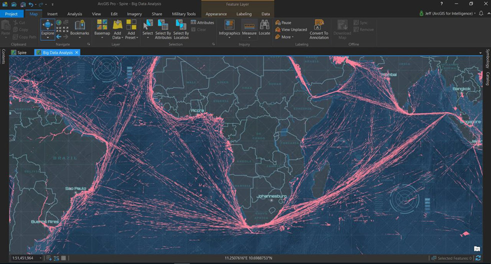
Don’t stop there! Read about Planet, the breadloaf satellites, current population 300 with more coming, beaming down 1.2 million high-resolution Earthly images per day, useful for agriculture, defense, mapping and GIS, and a few other industries.
If a group of satellites is a constellation, what do you call a group of constellations? If we are to follow astronomy’s lead, I’ve just learned that the proper technical term is an asterism. However, I think galaxy will be easier to handle.
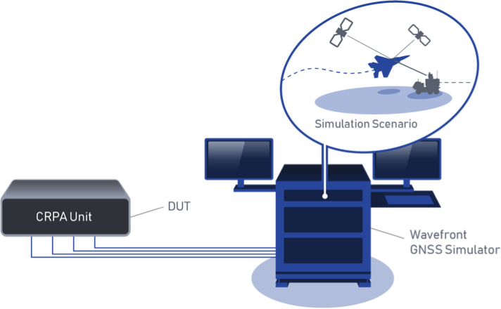
BroadSim Wavefront Simulator at work. (Image: Talen-X)
Talen-X has added the BroadSim Wavefront Simulator to its software-defined platform.
The BroadSim Wavefront further extends the capabilities achieved by BroadSim Anechoic, incorporating support for controlled radiation pattern antenna (CRPA) and multi-element receiver testing.
BroadSim, powered by Skydel SDX, has brought new innovations to the forefront each year to meet the growing needs of Talen-X’s customers, and the new wavefront simulator is the latest advancement.
Its features include:
Phase-coherent simulation
Real-time automated phase calibration
Scalable from 4 to 16 elements
Advanced jamming and spoofing scenarios.
Talen-X engineers are approaching delivery of an operational demonstration unit, as well.
BroadSense Nano
The BroadSense Nano GPS jamming sensor is the newest addition to Talen-X’s BroadSense product line. It has the smallest size, weight and power of any BroadSense product.
The video below features shows a prototype of the Nano, as well as information about its features and a demonstration of the unit reacting to various jamming waveforms in real time.
Four engineers — Dr. Bradford Parkinson, Professor James Spilker, Hugo FrueHauf and Richard Schwartz — were honored for creating the first truly global, satellite-based positioning system. The QEPrize is a prestigious worldwide engineering accolade, a £1 million prize that celebrates the global impact of engineering innovation on humanity.
The 2019 winners were announced Feb. 12 by Lord Browne of Madingley, chairman of the Queen Elizabeth Prize for Engineering Foundation, in the presence of HRH The Princess Royal (Princess Anne) in London.
The four winners will be formally honored at a ceremony later this year; they will receive the £1 million prize and an iconic trophy designed by the 2019 Create the Trophy competition winner, 16 year-old Jack Jiang from Hong Kong.
Why GPS
An estimated four billion people use GPS, and its annual economic value has been estimated to be $80 billion for the U.S. alone. Its applications range from navigation and disaster relief through to climate monitoring systems, banking systems, and the foundation of tomorrow’s transport, agriculture and industry.
The basic tracking required for GPS dates back to the start of the space race, when radio operators tracked Sputnik I on its groundbreaking flight in 1957. Sputnik’s radio signals appeared to drop in frequency as it passed overhead, a phenomenon known as the Doppler shift that allowed the satellite’s position to be determined.
The GPS Creators
The chief architect, Bradford Parkinson, is often called the “father of GPS” after successfully building upon several separate systems to create the current GPS design. Parkinson directed the program and led the development, design, and testing of its key components.
Parkinson insisted that GPS needed to be intuitive and inexpensive, which later made navigation accessible to billions. In 2016, Parkinson was honored with the Marconi Prize. To learn more about his achievements and how GPS began, read this article.
To realize the project, Parkinson recruited James Spilker to design the signal that the satellites broadcast. This type of ranging signal is critical to the success of GPS for civilian use; it is resistant to jamming, precise, and allows multiple satellites to broadcast on the same frequency without interfering with each other.
The 2019 QEPrize trophy, designed by 16-year-old Jack Jiang. (Photo: QEPrize)
Spilker’s team also developed and built the first receiver to process the GPS satellite signals; his delay-locked loop process, used for tracking code division multiple access (CDMA) signals, is essential to GPS accuracy.
GPS receivers rely on accurate timing information, broadcasted from satellites, to determine their position on earth. Each satellite uses multiple atomic clocks — accurate to within billions of a second — to ensure consistent timing. Hugo Freuhauf, then chief engineer at Rockwell Industries, led the development of a miniaturized, radiation-hardened atomic clock — the heart of the GPS satellite. Its accuracy is the backbone of communications systems, power grids, financial networks and other critical infrastructure.
For the GPS program to be affordable, each satellite had to be long-lived. Richard Schwartz, the program manager at Rockwell during the development of these satellites, was tasked with ensuring a three-year life span. His design was resistant to the intense radiation from the upper Van Allen belt, and it also lasted for more than nine years.
Reflections from the Winners
“One of the most important things we had when the project started was a vision of world impact. Without that inspiration, it would have been difficult for us to weather the storms of doing something for the first time,” Parkinson said.
An infographic by the QEPrize organization explains the history of GPS.
“Back in 1978, I made a few drawings that depicted GPS applications that I could personally foresee; they included an automobile navigation system, semi-automatic air traffic control, and wide-area vehicle monitoring, and seem to be rather accurate 41 years later,” Parkinson said. “That said, none of us could fathom the sheer breadth of GPS applications — the many ways that it would become a ‘System for Humanity’.”
In reflecting on the impact of GPS, Freuhauf said, “What surprised me the most was the general response from industry – it blew me away. The world’s tech industry reduced a 40-pound, $100,000 backpack-sized GPS receiver into a fingernail-sized chip receiver that now costs less than $2. Because of that, GPS is everywhere; it is part of the global economic engine and key to global safe-keeping. It’s had an almost unimaginable impact on the globe.”
“It’s hard to imagine what young and creative engineers will come up with next,” Schwartz said. “It’s such a rapidly developing world. That said, in the not too distant future I think I will be able to step into a driverless car, tell the car where I’d like to go, and then sit back and enjoy the ride.”
A SpaceX Falcon 9 rocket lifts off from Space Launch Complex 4E at Vandenberg Air Force Base, California, Jan. 14. (Photo: SpaceX)
Starting this month, the inspector general for the U.S. Pentagon will be reviewing how SpaceX’s rockets became certified to launch payloads for the U.S. Air Force, a decision made in May 2015.
“Our objective is to determine whether the U.S. Air Force complied with the Launch Services New Entrant Certification Guide when certifying the launch system design for the Evolved Expendable Launch Vehicle-class SpaceX Falcon 9 and Falcon Heavy launch vehicles,” wrote Michael J. Roark, deputy inspector general for Intelligence and Special Program Assessments, in a Feb. 11 memorandum to the Air Force.
In April 2016, the U.S. Air Force awarded SpaceX the first competitively sourced National Security Space (NSS) launch services contract in more than a decade, when the company won the GPS III Launch Services contract, fixed at $82,700,000.
Less than one year later, SpaceX was awarded a second contract for launch services to deliver a GPS III satellite to its intended orbit.
The evaluation will be performed at the Space and Missile Systems Center, a unit of Air Force Space Command, headquartered at Los Angeles Air Force Base in El Segundo, California. Additional locations may also be identified as part of the audit.
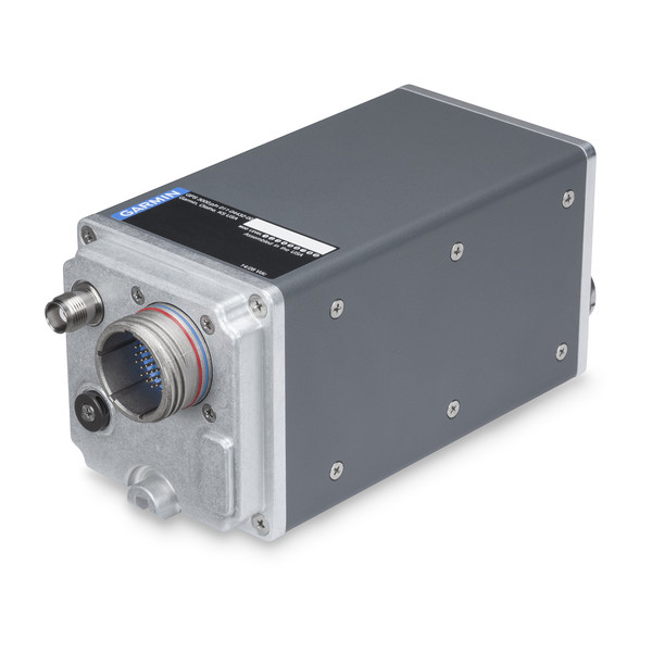
Garmin International Inc., a unit of Garmin Ltd., has launched the GPS 3000, a high-integrity GPS position sensor that interfaces to existing avionics to help meet Automatic Dependent Surveillance-Broadcast (ADS-B) Out requirements.
Also, targeting the air transport and defense markets, the GPS 3000 is designed as a WAAS/SBAS position source for select Flight Management Systems (FMS).
Aircraft that are eligible to utilize the GPS 3000 as an ADS-B position source include the Embraer E135/E145 and the Legacy 600/650. Supplemental Type Certification (STC) for the GPS 3000 in these aircraft is currently available from FTI Engineering, in cooperation with Atlas Air Service in Germany, and can be installed throughout the entire Garmin dealer network.
“Garmin continues to lead the industry with the most fielded ADS-B solutions that span all segments of aviation, including a wide-range of commercial, defense, regional and business aircraft,” said Carl Wolf, vice president of aviation sales and marketing. “We are thrilled to provide these aircraft with a solution that is cost-effective and is an easy to install alternative to the existing avionics manufacturer’s service bulletin.”
A rugged, stand-alone and certified Wide Area Augmentation System (WAAS)/Satellite-Based Augmentation System (SBAS) GPS, the GPS 3000 meets DO-160 and DO-178B standards and is designed specifically for the harsh environmental conditions encountered by commercial aircraft.
This compact and remote-mount solution utilizes enhanced WAAS/SBAS GPS satellite signals to provide precise position data through a standard interface. It also meets applicable high-integrity ADS-B position source standards, including TSO-C145d Class 3, the company said.
The GPS 3000 is also designed to interface with select FMS to support GPS guidance throughout terminal, enroute and approach navigation. When configured appropriately, the GPS 3000 is capable of providing position information to an existing FMS to meet requirements for Required Navigation Performance (RNP) and can support GPS-based vertical approach navigation, such as Localizer Performance with Vertical (LPV) approach guidance.
European Aviation Safety Agency (EASA) STC of the GPS 3000 in the Embraer E135/E145 and Legacy 600/650 is available from FTI Engineering, in cooperation with Atlas Air Service, as well as Garmin dealers. FAA validation of the STC is pending.
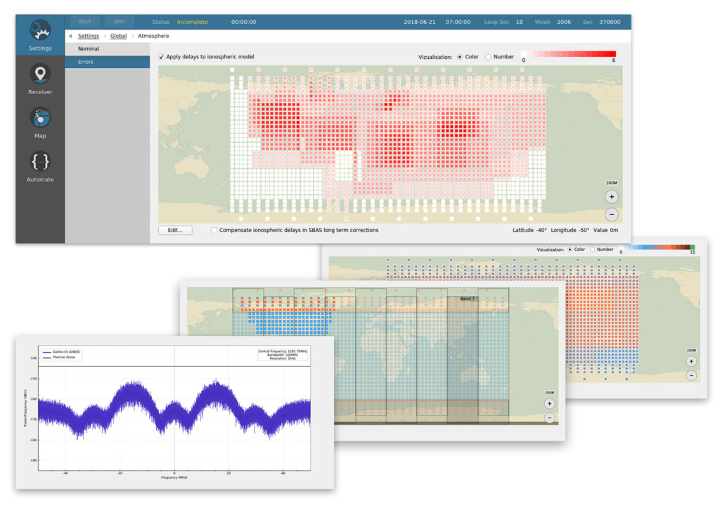
Skydel Solutions has updated its SDX GNSS simulator to version 19.1. The new version adds Galileo AltBOC signal generation, new atmospheric errors, SBAS improvements and SV antenna patterns.
Galileo AltBOC. SDX now supports Galileo AltBOC as a new GNSS signal type. Current SDX users licensed with the Galileo E5 signal will be able to generate 8 Phase Shift Keying (8-PSK) constant envelope AltBOC after upgrading to SDX 19.1.
The signal can be generated by selecting both Galileo E5a and E5b in the output – signal selection panel.
A montage of screenshots showing the various updates. (Image: Skydel)
Atmospheric Delays and Improvements to SBAS. Version 19.1 adds a new error type to all SDX users: atmospheric delays. These errors can be compensated with SBAS for SDX licensees with the SBAS option installed. The SBAS message now broadcasts ionospheric error corrections.
Three new interfaces help create, manage and use these error values in simulation scenarios.
Atmospheric Errors (Settings : Global). This panel enables users to review and edit the ionospheric delay values for any SBAS Ionospheric Grid Points (IGPs) . The map view can be navigated (pan and zoom) much like the map panel of the simulation. The edit button brings up an IGP editor used to assign the points values or increase their current value by a set amount.
Since the number of points in the grid is fairly large, the user interface works with a selection of points, allowing users to add or remove the current selection in order to quickly work your way around the whole map.
Atmospheric errors are available to all SDX licensees with the 19.1 upgrade.
Ionospheric Masks (Settings : SBAS). SDX users with the SBAS option can use this new interface to assign the true/false value for each point of the different SBAS bands, per service provider. It reuses most of the paradigm of the aforementioned atmospheric error pane.
Ionospheric GIVE Indicators (Settings : SBAS). Using a similar map interface as the two previous panels, the GIVEI (GIVE Indicators) panel enables you to provide the GIVE Indicator values for each IGP that is configured in the mask, per service provider.
The grids created or modified with these new options can all be saved and imported back into future SDX scenarios.
New GNSS Satellite Antenna Patterns. Also new in SDX 19.1 is the possibility to add user-defined antenna patterns to GNSS satellites. These new antenna pattern options show SDX’s flexibility by allowing any user-defined antenna pattern to be applied to any satellites in any GNSS constellation.
This can prove especially useful for scientists and engineers working with space vehicles, due to their unusual orientation when compared to surface vehicles. High-Earth-orbiting spacecraft benefit from the side lobes of GNSS satellites to improve navigation performance. In fact, when tracking the signal from side lobes, the number of visible satellites is drastically increased, and the precision can improve from the kilometer to the meter level.
In addition, the new antenna patterns can be a potent tool in the context of research projects that experiment with user-defined GNSS SV Antennas.
SV antenna patterns in SDX. SDX now allows you to create, define, and manage antenna patterns for GNSS satellites using an interface very similar to the one we introduced for vehicles in SDX 18.10. As with that release, the various patterns are organized into antenna models that can be named, managed, exported, and reimported back into other simulation scenarios.
The user interface has also been improved. Read more about the changes in Skydel’s blog.
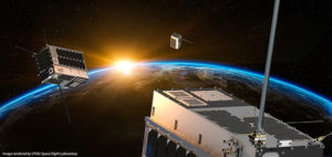
Space Flight Laboratory (SFL) has launched three formation-flying HawkEye 360 Pathfinder 15-kilogram, 20 x 27 x 44-centimeter microsatellites designed to detect and geolocate radio frequency (RF) signals.
Hawkeye 360 Pathfinder satellite trio flies in formation, seeking RF signals from Earth. (Image: UTIAS Space Flight Laboratory)
The target signals emanate from VHF radios, maritime radar systems, automatic identification system (AIS) beacons, very small aperture terminal (VSAT) communication systems and emergency beacons. HawkEye 360 applies advanced RF analytics to the data to assess suspicious vessel activity, survey communication frequency interference and direct search-and-rescue.
Precise formation flying is critical, as the relative position of each satellite must be known to accurately geolocate transmission sources. The satellites carry space-qualified GPS receivers and high-performance attitude control systems to keep them stable in orbit.
Flying in formation, two or all three satellites may receive the same transmission when it originates from their common footprint. The signal’s different times of arrival at each satellite and their different apparent center frequencies (Doppler) will enable onboard comparison of time-of-arrival and frequency-of-arrival measurements to then calculate the transmitter’s position.
The onboard GPS receivers provide precise estimates for the position and velocity of the receivers, information required for multilateration. The satellites further synchronize their clocks using GPS receivers, which also stabilize the phase-locked loops governing the tuning frequency in the RF tuners.
The satellites were built by Deep Space Industries of San Jose, California, and University of Toronto, Institute for Aerospace Studies/Space Flight Laboratory (UTIAS/SFL). They were launched in December 2018 into low-Earth orbit.
The latest four Galileo satellites have been given the green light to begin working alongside the rest of Europe’s satellite navigation fleet, giving a further boost to worldwide Galileo service quality.
Galileo has grown to become Europe’s single largest satellite constellation, built up over 10 launches over the course of this decade. The first of seven double-satellite Soyuz launches took place in 2011, with three sets of four-satellite Ariane-5 launches during the last three years.
The latest quartet of Galileo satellites were launched together by Ariane 5 on July 25, bringing the number of satellites in orbit to 26.
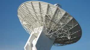
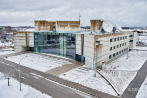
L-band antenna at Redu. (Photo: ESA)
Once safely in orbit the satellites entered their in-orbit test commissioning, overseen by a combination of facilities across Europe.
The Launch and Early Operations Phase team of France’s CNES space agency in Toulouse worked together with the two Galileo control centres in Fucino, Italy, and Oberpfaffenhofen, Germany and ESA’s Redu centre in Belgium.
Redu’s 20-m antenna played an important part during in-orbit testing, allowing for high-resolution monitoring of the L-band navigation signal coming from each satellite.
The two control centres participated by testing their control of the satellites. The operations teams confirmed their fully-trained status and their readiness to manage the fleet now it has swelled to 26 satellites in total.
Galileo’s Control Centre in Fucino is used to oversee the satellites’ navigation payloads and services. (Photo: ESA)
David Sanchez-Cabezudo, ESA’s Galileo In-Orbit Testing manager commented: “All the lessons learned and experience gained in these last years through the Galileo satellite commissioning campaigns have led us to a high level of efficiency and effectiveness — not only in managing the technical aspects of the testing operations but the large number of interfaces at contractual and human levels. A complex network of teams has had to work together to make this activity work.”
Galileo satellites orbit in three orbital planes in medium Earth orbit, 23 222 km up. The result is that at least four Galileo satellites should be visible from any point on Earth — the minimum needed to achieve a position fix.
Galileo’s Control Centre in Oberpfaffenhofen in Germany oversees the Galileo satellite platforms. (Photo: ESA)
Oberpfaffenhofen Control Centre
Galileo Initial Services commenced on Dec. 15, 2016, with each new addition to the working constellation serving to enhance the stability and speed of the system.
A further 12 Galileo satellites are currently in production by the same industrial consortium — with OHB manufacturing the satellite platforms and Surrey Satellite Technology Ltd the navigation payloads.
The next Galileo launch is schedule for 2020, the same year that Full Operational Capability is set to start.
The Galileo programme is funded and owned by the EU. The European Commission has the overall responsibility for the programme, managing and overseeing the implementation of all programme activities.
ESA is entrusted with Galileo’s deployment, the design and development of the new generation of systems and the technical development of infrastructure. The definition, development and in-orbit validation phases were carried out by ESA, and co‑funded by ESA and the European Commission.
The European Global Navigation Satellite System Agency (GSA) ensures the uptake and security of Galileo. Galileo operations and provision of services became the responsibility of the GSA in July 2017.
Spire Global, a space-to-cloud analytics company, is now using Galileo to offer GNSS radio occultation (GNSS-RO) products for the weather community. Radio occultation is the process of using satellites to measure how GNSS signals are refracted by the Earth’s atmosphere.
Two of Spire’s nanosatellites are the first to use Galileo signals to measure GNSS-RO profiles, a service now available to Spire’s global user base as a new tier of data for advanced weather prediction. The satellites launched on Nov. 29, 2018, from Sriharikota, India.
The satellites are part of the collaborative European Space Agency ARTES Pioneer Space-as-a-Service program, which aims to prove the value of using nanosatellites for space-based GNSS-RO.
With Galileo, Spire’s weather observation satellites can harvest approximately 25 percent of the total GNSS-RO profiles available from the existing GNSS satellite constellations in orbit today.
Spire operates 72 nanosatellites — also known as “cubesats” — and more than 30 ground stations throughout the world. The nanosatellites are developed, assembled and tested at Spire’s production facility in Glasgow, Scotland.
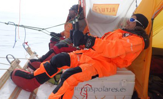
A kite-blown science expedition to the interior of Antarctica has made the most southerly positioning fixes yet made with Europe’s Galileo satellite navigation system.
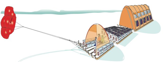
The Inuit WindSled is a multi-part sledge the size of a lorry, complete with mounted tents and solar power panels, pulled through the ice using a mammoth 150 sq. m. diameter kite. (Photo: Inuit WindSled via ESA)
Their measurements not only confirm Galileo performance at extremely high latitudes, but also offer knowledge of space weather events overhead. In particular they offer insights into the ionosphere — the electrically active upper layer of Earth’s atmosphere — above the southern continent, and the performance of Galileo software to correct ionospheric interference.
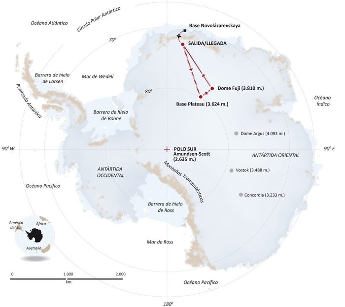
The four-person expedition left Russia’s Novolazarevskaya Base on 12 December last year. For more than 40 days they made their way to Dome Fuji, a 3810-meter-high ice dome in Eastern Antarctica — one of the coldest places on Earth. After reaching the high point on 21 January, they are now back at the Russian base.
The Inuit WindSled is a multi-part sledge the size of a lorry, complete with mounted tents and solar power panels, pulled through the ice using a mammoth 150 sq. m kite. (Graphic: ESA)
The “Antarctica Unexplored 2018-2019″ expedition, mounted by Spain’s Asociación Polar Trineo de Viento, is employing a unique zero-emission vehicle specially designed for polar exploration. The Inuit WindSled is a multi-part sledge the size of a lorry, complete with mounted tents and solar power panels, pulled through the ice using a mammoth 150 sq. m kite.
The Windsled’s inventor, Ramón Larramendi, is also the expedition leader. “This marks the first time we’ve climbed the Fuji Dome in a vehicle driven by the wind — everyone who reached there before relied on motorised vehicles. So this is also the first time we’ve traveled more than 2,400 km with more than 2,000 kg of cargo using a vehicle that does not pollute the Antarctic continent,” Larramendi said.
“We are also doing this in collaboration with ESA, among other scientific institutions, which is very important because it allows us to demonstrate this polar eco-vehicle has excellent possibilities for enabling science in the interior of the Antarctica continent,” Larramendi said.
The four-person “Antarctica Unexplored 2018-2019” expedition left Russia’s Novolazarevskaya Base on Dec. 12, 2018. For more than 40 days they made their way to Dome Fuji, a 3810-meter-high ice dome in Eastern Antarctica — one of the coldest places on Earth. (Graphic: ESA)
The expedition carries a total of 10 scientific experiments from different research institutions, covering fields such as climate change, meteorology and astrobiology. ESA’s involvement with the expedition is the Galileo Experimentation and Scientific Test in Antarctica (GESTA) project.
GESTA involves regular positioning fixes being made over the course of the expedition for all satellite navigation constellations in all kinds of weather and geomagnetic conditions encountered. ESA provided the satnav receiver, with GMV in Spain contributing an advanced signal recorder for data analysis.
One of the important aspects of the study is the monitoring of the ionosphere in such high latitudes during low solar activity. Ionospheric interference can degrade satellite navigation performance, and its incidence is linked to solar activity.
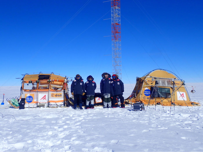
The expedition team with their Inuit WindSled at the high point of Dome Fuji. Note the ESA logo on the left tent of the WindSled. (Photo: Inuit WindSled via ESA)
GESTA is overseen by ESA’s Galileo Navigation Science Office, led by Javier Ventura-Traveset. “We are very pleased with this pilot scientific experience, having been able to collect Galileo measurements all over the expedition trip as planned,” said Ventura-Traveset. “The expedition reached latitudes near 80 degrees south, to our knowledge the most southerly latitude measurements ever-performed in-situ with Galileo in its current near-complete constellation status.
“We have also collected data from all other global satellite navigation systems and all available different frequencies, which will allow us also to assess multi-constellation solutions and compare their performance on these conditions. The expedition team kept in continuous contact via satellite with our office, allowing us to plan their activity, asking, for example, for dedicated data collections during space weather relevant events.”
“Once the expedition data are delivered, we will be able to assess Galileo positioning, navigation and timing capabilities at polar latitudes and how they are influenced by space weather events during low solar activity,” said Manuel Castillo, system engineer at the Galileo Navigation Science Office. “In particular, we will analyze if the occurrence of coronal holes is correlated with observed ionospheric interference. Coronal holes are open areas in the Sun’s outer layer, the corona, that allow the solar wind to leave the Sun and reach Earth, triggering moderate geomagnetic storms.
“At this moment in the 11-year solar cycle, with the Sun close to minimum activity, full-scale solar storms are not frequent, but the ongoing communication between the WindSled team and the Galileo Navigation Support Office allowed us to coordinate measurement times during the three minor geomagnetic storms the expedition experienced during the trip.”
A coronal hole in the Sun, observed by NASA’s Solar Dynamics Observatory on Jan. 5, 2019. (Photo: NASA)
The coronal holes triggering these geomagnetic storms were monitored, meanwhile, by Sun-watching missions such as NASA’s Solar Dynamic Observatory, the NASA-ESA SOHO and ESA’s Proba-2.
ESA’s Galileo Navigation Science Office is based in European Space Astronomy Centre, ESAC, near Madrid. It was set up in 2016 as a joint initiative between ESA’s Science and Navigation Directorates, coordinating scientific opportunities through interaction with the scientific community and the independent GNSS Science Advisory Committee.
The EUMETSAT Polar System is considering providing GNSS navigation bit data, should there be sufficient interest in the user community.
“In the framework of the development of the radio occultation data processor for the new EUMETSAT Polar System – Second Generation mission, we envisage a GNSS Navigation Bit Data product,” wrote Riccardo Notarpietro, a remote sensing scientist with EUMETSAT’s radio occultation team, in an email.
“This product will contain the bit stream of each of the GNSS navigation messages which are modulating the open service GNSS signals. We are thinking to provide this product operationally on an hourly base covering the last hour of observations from a dedicated ground-based network of GNSS receivers.”
If there is sufficient interest, the data would be made available from the EUMETSAT data distribution system. Notarpietro invites those who are interested or have questions to contact the team at [email protected].
EUMETSAT is the European Organisation for the Exploitation of Meteorological Satellites. The second-generation of the polar system, also known as EPS-SG, will secure the continuation of meteorological observations from polar orbit in the 2022-2043 timeframe.
The program is open to graduate students (with a first university degree), Ph.D. candidates, early-stage researchers and young professionals willing to broaden their knowledge. The 50 available seats will be given on a first-come, first-served basis.
The mission of the ESA-JRC International Summer School on GNSS is to provide the attendees with a comprehensive overview of satellite navigation. Extensive lab work will provide attendees with hands-on learning opportunities.
Topics covered include:
Basics of satellite navigation
Carrier-phase positioning
GNSS RF link performance
Ionospheric and tropospheric effects on GNSS
and more
The summer school’s objective is to provide attendees with a comprehensive overview on satellite navigation, starting from the GNSS system, its signals, the processing of the observations in a receiver and finally determining the position-navigation-time (PNT) solution.
Lectures on intellectual property rights (IPR) and patents, as well as on business aspects, will be given. The future of satellite systems will also be discussed.
The main emphasis will be on the development of a group project using innovative ideas and covering all aspects, from the initial concept, to a business plan, its technical realization and marketing of the product or service.
Internationally renowned scientists and specialists will give lectures as well as practical exercises and lab work.