A black hole has been imaged for the first time. The image was captured by a world-spanning network of radio telescopes that together create the Event Horizon Telescope.
It zeroed in on the supermassive monster in the galaxy M87 to create the image.
For GNSS experts, black holes demonstrate the extremes of relativity. Time and space warp and bend in response to mass and movement, an effect we experience whenever we use GNSS.
GPS satellites move about 14,000 kilometers per hour, in a weak gravitational field about 20,000 kilometers above us. Because of relativity, the clock rates of the satellites would drift by about 38 microseconds per day, causing a positioning error of about 10 kilometers if not accounted for.
Near black holes, of course, the time-warping effect becomes extreme, slowing the closer we get to the event horizon.
“…because the satellites are constantly moving relative to observers on the Earth, effects predicted by the Special and General theories of Relativity must be taken into account to achieve the desired 20-30 nanosecond accuracy.
“Because an observer on the ground sees the satellites in motion relative to them, Special Relativity predicts that we should see their clocks ticking more slowly. Special Relativity predicts that the onboard atomic clocks on the satellites should fall behind clocks on the ground by about 7 microseconds per day because of the slower ticking rate due to the time dilation effect of their relative motion.
“When viewed from the surface of the Earth, the clocks on GPS satellites appear to be ticking faster than identical clocks on the ground. A calculation using general relativity predicts that the clocks in each GPS satellite should get ahead of ground-based clocks by 45 microseconds per day.
“The combination of these two relativsitic effects means that the clocks on-board each satellite should tick faster than identical clocks on the ground by about 38 microseconds per day (45-7=38). This sounds small, but the high-precision required of the GPS system requires nanosecond accuracy, and 38 microseconds is 38,000 nanoseconds.
“If these effects were not properly taken into account, a navigational fix based on the GPS constellation would be false after only 2 minutes, and errors in global positions would continue to accumulate at a rate of about 10 kilometers each day. The whole system would be utterly worthless for navigation in a very short time.”
To counteract the General Relativistic effect once on orbit, the onboard clocks were designed to “tick” at a slower frequency than ground reference clocks, so that once they were in their proper orbit stations their clocks would appear to tick at about the correct rate as compared to the reference atomic clocks at the GPS ground stations.
The microcomputer in each GPS receiver not only performs the calculation of position using 3D trilateration, it also computes any special relativistic timing calculations required using data provided by the satellites.
GPS indispensable to capturing image
Innovation editor Richard Langley explained that the technique used to get the black hole image relies on GPS. Known as very long baseline interferometry, the technique links two or more radio telescopes that can be many kilometers apart — even on different continents. The technique is used in both in geodesy and astronomy. GPS World discusses the method here.
There is also a practical GPS link to the Event Horizon Telescope. From the second of six simultaneously published open-access papers on the result:
“All timing is locked to a 10 MHz [hydrogen] maser reference and synchronized with a pulse-per-second (PPS) Global Positioning System (GPS) signal….”
“[T]he long-term drift of the maser at the SMA compared to GPS, measured by differencing the 1 PPS ticks from the maser and local GPS receiver. The vertical width of the trace is due to variable ionospheric and tropospheric delays of the GPS signal (including the excursion near hour 200), while the long-term trend represents the frequency error of the maser. The drift measured from this plot, and its effects on the fringe visibility, are removed during VLBI correlation.”
“In order to reconstruct the brightness distribution of an observed source, VLBI requires cross-correlation between the individual signals recorded independently at each station, brought to a common time reference using local atomic clocks paired with the Global Positioning System (GPS) for coarse synchronization.”
So, GPS is indispensable to the technique and the success of obtaining the image.
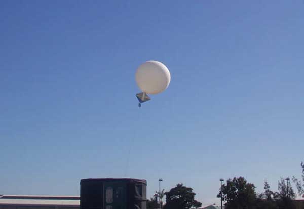
Launch of a weather balloon in Australia. (Photo: Townsville Meteorological Office/Bureau of Meteorology)
The GPS Week Number Rollover, which took place April 6, has grounded the Australian Bureau of Meteorology’s (BOM) weather balloons.
The fault was caused by the rollover of the time stamp in GPS signals, reports ABC news, which caused a “technical fault with the equipment’s communications systems.”
The weather balloons carry a radiosonde that includes GPS tracking. The radiosondes measure various atmospheric parameters and transmits them by radio to a ground receiver.
BOM said its equipment supplier advised the bureau of the fault after the rollover on April 7, and balloon launches ceased on April 8.
GPS clocks returned to zero early on Sunday morning.
Usually, BOM launches 56 weather balloons each day from 38 locations to provide vital information to help meet international obligations under the Convention of the World Meteorological Organization.
Boeing aircraft affected
Also affected by the rollover were some Boeing aircraft. The GPS clock rollover caused “a limited number of 787 airplanes” to display the wrong date, according to Boeing, causing them to be temporarily grounded in China.
Other reports are that at least one KLM 777 flight and a large number of China Airlines 777 and 787 aircraft were grounded due to the issues, while technicians updated the software. A Shanghai Airlines 787 was also reportedly affected.
In all the reported cases so far, the GPS systems were supplied by Honeywell, which issued a service update on the issue.
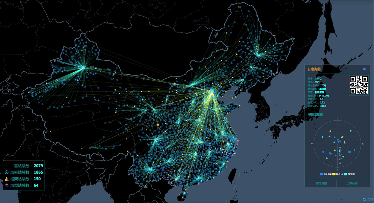
China’s National Reference Station Network. (Image: BeiDou)
The second China-Arab States BDS Cooperation Forum, held April 1 in Tunis, Tunisia, covered measures and initiatives that will increase the use of China’s Beidou navigation satellite system (BDS) in the Arab world. The aim is to establish a Space Silk Road that elevates cooperation in high-technology between China and the Middle East and North Africa, reports spacewatch global.
The forum concluded that increased BDS use in the Arab world, as well as technological cooperation with China, could be achieved by establishing the Space Silk Road.
By formally establishing a Silk Road conceptual theme, forum participants believe that Arab countries will step up their use of BDS for everything ranging from precision agriculture and maritime domain awareness to disaster management and telecommunications.
“The BDS cooperation is the best example for the strategic cooperation between China and Arab states, as satellite navigation integrates many high-tech areas, including telecommunication and space technologies,” said Slim Khalbous, Tunisia’s minister for higher education and scientific research in an address to the forum. “This is an important opportunity for Tunisia, while the BDS cooperation also means the further upgrade of the China-Arab relations.”
“Satellite navigation has provided many conveniences and benefits for us, and we are determined to push forward with our cooperation,” said Mohamed Ben Amor, secretary-general of the Arab Information and Communication Technologies Organization (AICTO), in the forum’s opening speech.
Amor added that the establishment of the China-Arab States BDS/GNNS Centre in Tunis in 2018 is an important step in increasing Sino-Arab cooperation in satellite positioning, navigation, and timing (PNT) applications through BDS.
Kamal Hassen Ali, assistant secretary general of the Arab League in charge of economic affairs, celebrated the burgeoning cooperation between China and Arab states. “The size of our cooperation will grow bigger, as the China-Tunisia cooperation has borne many fruits, and it will achieve greater progress in other countries in the region too.,” Ali said.
The China-Arab States BDS Cooperation Forum is a multilateral initiative for promoting cooperation and exchanges between China and Arab states in the field of satellite navigation within the framework of the China-Arab States Cooperation Forum. The first forum was held in Shanghai, China, in May 2017.
GPS signals extend farther than expected, meaning future space missions can reliably use GPS at extreme altitudes.
By Danny Baird
NASA’s Goddard Space Flight Center, Greenbelt, Maryland
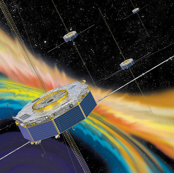
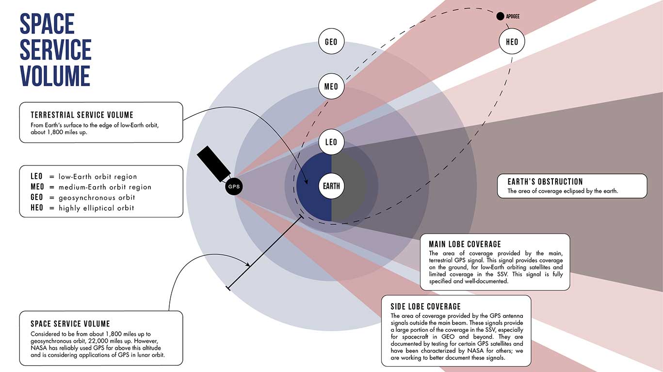
The four Magnetospheric Multiscale (MMS) spacecraft recently broke the world record for navigating with GPS signals farther from Earth than ever before. MMS’ success indicates that NASA spacecraft may soon be able to navigate via GPS as far away as the Moon, which will prove important to the Gateway, a planned space station in lunar orbit.
After navigation maneuvers conducted this February, MMS now reaches over 116,300 miles from Earth at the highest point of its orbit, or about halfway to the Moon. At this altitude, MMS continued to receive strong enough GPS signals to determine its position, shattering previous records it set first in October 2016 and again in February 2017.
This demonstrates that GPS signals extend farther than expected and that future missions can reliably use GPS at extreme altitudes.
“At the first apogee after the maneuvers, MMS1 had 12 GPS fixes, each requiring signals from four GPS satellites,” said Trevor Williams, the MMS flight dynamics lead at NASA’s Goddard Space Flight Center in Greenbelt, Maryland. “When we began the mission, we had no idea high-altitude GPS would be such a robust capability.”
MMS’ orbit shift allows it to continue its mission to better understand the complex magnetic processes around Earth. MMS studies a fundamental process that occurs throughout the universe, called magnetic reconnection, in which magnetic fields collide and explosively release particles in all directions. Near Earth, reconnection is a key driver of space weather, the dynamic system of energy, particles and magnetic fields around Earth which can adversely impact communications networks, electrical grids and GPS navigation. Magnetic reconnection was long predicted by physicists, but not directly observed until the MMS mission.
To study Earth’s magnetosphere, the region of space dominated by the planet’s magnetic field, MMS spacecraft maintain a highly elliptical orbit around Earth. A highly elliptical orbit resembles a long oval around the globe with an extreme high point, or apogee, and low point, or perigee.
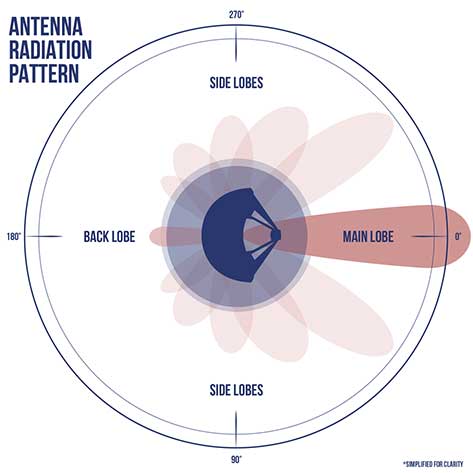
MMS’ tight formation and highly elliptical orbit require extremely accurate navigation data from GPS satellites, which are operated by the U.S. Air Force. The main GPS antenna signals enable navigation down on Earth, but precise high-altitude navigation requires both these as well as signals from the antenna’s side lobes. Side lobe signals radiate out to the side of the direction an antenna is pointing and extend past Earth.
A simplified antenna radiation pattern with different lobes of radiation extending from the antenna. (Image: NASA)
Communications engineers usually consider these side lobes wasted energy. However, the signals can be used by satellites at high altitudes on the opposite side of the globe as the GPS satellite. (Such high-altitude missions fly above GPS satellites’ orbit.) Previously, most engineers considered the upper limits of the GPS navigation in space to be an altitude of about 22,000 miles, or the altitude of satellites in geosynchronous orbit — until MMS.
Additionally, the navigation maneuvers allowed the spacecraft to gather data not available to scientists during normal operations.
“MMS usually flies in a close, tetrahedral formation [that looks like a pyramid],” said Thomas Moore, the project scientist for MMS at Goddard. “During the orbit-raising maneuvers, the spacecraft became a [straight line or] ‘string of pearls,’ which gave us unique data about the magnetosphere that may further our understanding of magnetic reconnection.”
MMS’ tight configuration and record-breaking GPS fixes would not be possible without the mission’s Navigator GPS receiver, an instrument developed at Goddard. It can detect faint GPS signals while withstanding the harsh radiation environment within the magnetosphere. NASA has made this revolutionary technology available for licensing through the Technology Transfer program, ensuring that commercial enterprise can also benefit from this innovation.
A diagram showing how GPS antenna signals can serve spacecraft at high altitudes. (Image: NASA)
In fact, NASA simulations show GNSS signals could even be used for reliable navigation in lunar orbit, just as a car uses GPS on an interstate highway. Engineers are considering using GNSS signals in the navigation architecture for the Gateway, an outpost in orbit around the Moon that will enable sustained lunar surface exploration.
“We’re working with the international community to document GNSS performance for space users, including side lobe signals,” said Joel Parker, a Goddard navigation engineer representing NASA internationally in GNSS policy. “A better understanding of GNSS capabilities will allow high-altitude missions to take advantage of the robust navigation signals they provide.”
Illustration of the four MMS spacecraft in orbit in Earth’s magnetic field. (Image: NASA).
Thanks to MMS and NASA’s navigation engineers, the sky is no longer the limit.
NASA’s Science Mission Directorate provides strategic oversight to MMS. Goddard’s Explorers and Heliophysics Projects Division manages the mission. The four MMS spacecraft launched on March 13, 2015, from NASA’s Kennedy Space Center in Cape Canaveral, Florida, on board an Atlas V launch vehicle.
NASA’s Space Communications and Navigation (SCaN) program office oversees the agency’s work in navigation policy related to GNSS. NASA, consulting the United Nations International Committee on GNSS (ICG), collaborates with other U.S. agencies and the six international GNSS providers to define GNSS requirements and develop additional capabilities. The team of SCaN navigation specialists charged with aiding the ICG are based out of the Exploration and Space Communications projects division at Goddard.
Spirent Federal Systems, a provider of GPS/GNSS test equipment, announced that Col. (retired) Bernard Gruber, former program director of what is now the U.S. Air Force GPS Directorate, has joined the company’s board of directors as government security committee chairman. Also joining as the chairman of the board is Robert Lollini.
Spirent Federal President/CEO Ellen Hall stated, “We are happy to have retired Col. Gruber and Bob Lollini joining our dynamic company. We are leading the industry in innovation and quality products for the U.S. government and these two new leaders will help us continue that momentum.”
Col. Bernie Gruber in 2012. (Photo: U.S. Air Force)
Bernard Gruber brings to the position the experience gained from a long and distinguished career in the government and military sector. Mr. Gruber has held several positions in important commands focused on navigation in space, including serving as the chief of Space and Global Integrated Intelligence at the Pentagon from 2009-2010, and director of the Global Positioning System (GPS) at the Los Angeles Air Force Base from 2010-2013. He is currently the director of Precision Guidance and Advanced Programs, Armament Systems at Northrop Grumman.
Robert Lollini is currently the chief executive officer and president of BioFire Defense LLC, a subsidiary and proxy company of bioMerieux. Lollini contributes to the board his broad understanding of strategic financial and executive management.
Spirent Federal Systems was formed in July 2001 by Spirent Communications as a wholly owned subsidiary and U.S. proxy company. Spirent Federal markets and sells Spirent Communications’ GNSS products in North America. The company also provides value-added features and ongoing customer support. Spirent Federal Systems is headquartered in Pleasant Grove, Utah, with support and sales offices throughout the U.S.
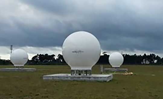
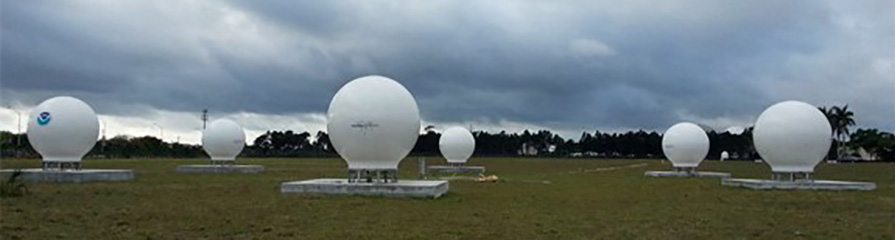
Orolia has successfully installed the first operational Cospas-Sarsat second-generation technology on search-and-rescue ground stations for the National Oceanographic and Atmospheric Administration (NOAA) in Florida and Hawaii.
The ground stations have been upgraded with second-generation beacon (SGB) signal-processing capabilities to more accurately and quickly locate the source of distress signals.
The NOAA Florida and Hawaii ground stations are the only operationally ready Medium Earth Orbit Search and Rescue (MEOSAR) ground stations in the world to receive the SGB signal specification capability.
The Cospas-Sarsat global search-and-rescue system developed specifications for the second-generation 406-MHz search-and-rescue beacon, which uses a modern, spread-spectrum signal to achieve more accurate and robust performance.
“The work performed by Orolia was exceptional, as the process of upgrading an operational system to a higher set of requirements, years after its initial design, involves minimizing downtime while validating the new requirements and revalidating the previous requirements,” said Mickey Fitzmaurice, NOAA SARSAT Systems Engineer. “The successful result makes it obvious that the engineering and operations team at Orolia put a great deal of time and effort into planning the upgrade, as the execution was seamless.”
“This series of world firsts demonstrates Orolia’s broad technical leadership in the global search and rescue ecosystem,” said Orolia Director of SARSAT Operations, Steve Ludwig. “We continually innovate to enhance the usefulness of these technologies, from generating encrypted beacon alert signals to including alert authentication through the use of Galileo Return Link Service.”
Cospas-Sarsat ground stations are called Local User Terminals (LUTs). These satellite receiving units are the ground stations that receive emergency beacon distress alerts. (Photo: NOAA)
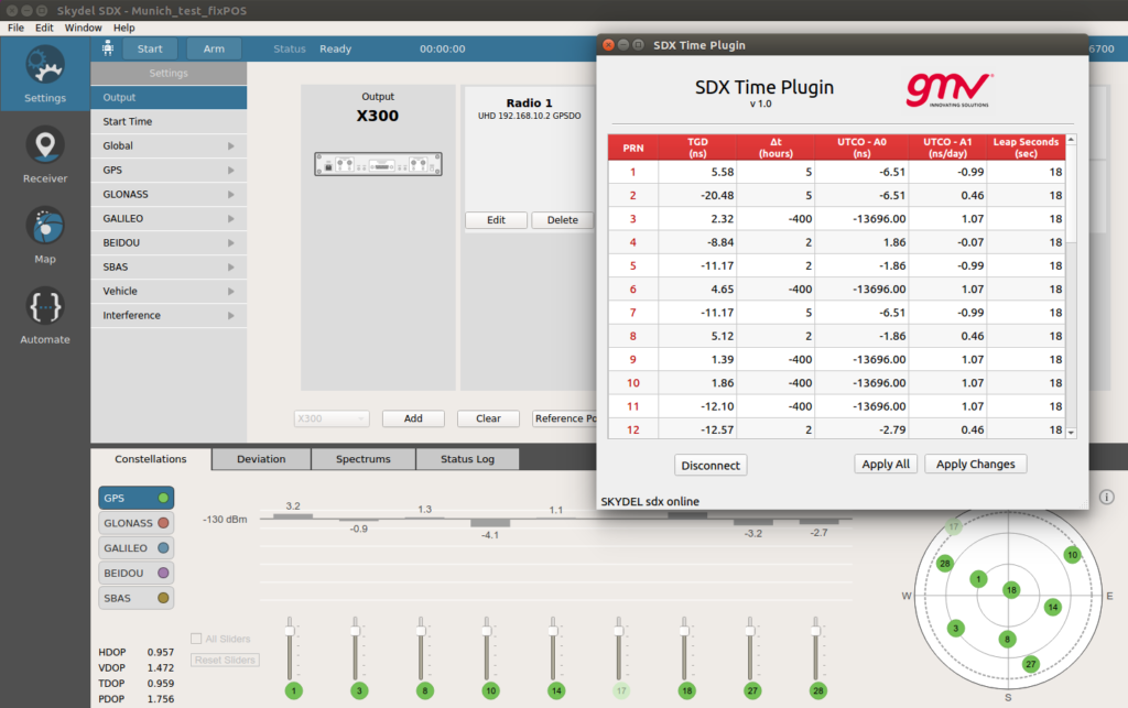
With Orolia’s Skydel SDX API, GMV has developed a “Time Plugin” that allows to batch edit the numerical values associated to TGDs, UTCO and Leap Seconds. (Image: GMV)
GMV uses the flexibility of Skydel SDX to simulate GNSS timing events.
The upcoming GPS Week Number Rollover (WNRO) on April 6 is a known feature of GPS that occurs only every roughly 20 years and thus can be anticipated and tested in a receiver using a GNSS simulator.
A less-known rollover effect is also present in the Week Number (WN) associated to the UTC Offset (UTCO) transmitted by GPS. This WN has only 8 bits, which implies a range of values from 0-255, equivalent to a rollover every roughly 5 years. A possible failure in the receiver interpretation of the UTCO WN would not have such dramatic effects as a general GPS WNRO, but it could seriously affect the output of a GPS timing receiver.
Other than WN rollovers, un-programmed GNSS timing glitches are extremely rare but not impossible. A well known case is the GPS anomaly of Jan. 25-26, 2016, when around half of the satellites in the constellation transmitted an incorrect UTCO value during 12 hours. The transmitted value was of the order of 13 microseconds, when the correct value is usually of the order of just a few nanoseconds. This caused many timing receivers around the world to provide an incorrect timing information or to fail altogether.
Other fields in the GPS navigation message that could potentially be corrupt and cause incorrect timing output are Timing Group Delays (TGDs), and Leap Second information. In general, any event related to the contents of the GPS navigation message can be simulated by editing the associated bits in the message, for each satellite PRN.
However this is a cumbersome and prone-to-error task. Orolia’s Skydel SDX simulator provides an Application Programming Interface (API) that allows to develop SDX extensions to tackle particular simulation problems in an easy and flexible way.
By using this API, GMV has developed a “Time Plugin” that allows to edit directly on a user interface the numerical values associated to TGDs, UTCO, and Leap Seconds, per individual satellite PRN. These values are then converted to bits in the GPS message and transmitted in the RF stream to feed the receiver under test. Events like, for example, the GPS anomaly of Jan. 25-26, 2016, can be easily tested (as shown in the screenshot).
Analysis of Satellite Data Exposes Threats to Civil Aviation
The Russian Federation is growing and actively nurturing a comparative advantage in the targeted use and development of GNSS spoofing capabilities to achieve tactical and strategic objectives at home and abroad.
Cover: C4ADS
A new report titled “Above Us Only Stars: Exposing GPS Spoofing in Russia and Syria,” presents findings from a year-long investigation ending in November 2018 on an emerging subset of electronic warfare (EW) activity: the ability to mimic, or spoof, legitimate GNSS signals to manipulate PNT data.
Using publicly available data and commercial technologies, the authors detect and analyze patterns of GNSS spoofing in the Russian Federation, Crimea and Syria. They profile different use cases of current Russian state activity to trace the activity back to basing locations and systems in use.
The report is issued by C4ADS, a Washington, D.C.-based nonprofit organization dedicated to providing data-driven analysis and evidence-based reporting on global conflict and transnational security issues. Its website, c4ads.org,lists transnational organized crime, proliferation networks (rogue nations and non-state actors), threat finance and supply-chain security as areas of focus.
Pinpointing interference. Todd Humphreys, a University of Texas at Austin associate professor and head of the university’s Radionavigation Laboratory, collaborated on the research underpinning the report.
Humphreys stated that, as far as he knew, the study constitutes the first characterization of GNSS interference from space, and cited “some interesting findings:
“Using Automatic Identification System (AIS) data captured by overhead satellites, we monitored spoofing in the Black Sea, around St. Petersburg, Archangelsk, etc., and built a picture of interference activity that spans two years. All such activities occur near Russian coastal waters.
“Correlating this activity with the travel schedule of the Russian head of state, we have strong evidence that the spoofing is a protective measure used to thwart drone attacks on Vladimir Putin.
“By exploiting a software-defined GNSS receiver my lab is operating on the International Space Station, we were able to pinpoint a powerful source of interference, which we found to be coming from the northwest quadrant of a Russian-operated airbase in Syria. This explains the many reports of GNSS interference in the eastern Mediterranean during the past year.”
Global Threat. The tools and methodologies for perpetrating GNSS interference are proliferating at a rapid rate, and the frequency of such incidents around the world increases steadily. GNSS attacks, and GPS attacks specifically, now constitute an active, present, disruptive strategic threat in every theater of operation.
The C4ADS website, in announcing the report, states that “The Russian Federation has a comparative advantage in the targeted use and development of GNSS spoofing capabilities. However, the low cost, commercial availability and ease of deployment of these technologies will empower not only states, but also insurgents, terrorists and criminals in a wide range of destabilizing state-sponsored and non-state illicit networks. GNSS spoofing activities endanger everything from global navigational safety to civilian finance, logistics and communication systems.”
Examining GNSS spoofing events across the entire Russian Federation, its occupied territories and overseas military facilities, the report identifies 9,883 suspected instances across 10 locations that affected 1,311 civilian vessel navigation systems since February 2016. It demonstrates that these activities are much larger in scope, more diverse in geography, and longer in duration than any public reporting suggests to date.
C4ADS believes the Russian Federal Protective Service (FSO) operates mobile systems to support this activity. It chronicles the use of GPS spoofing in active Russian combat zones, particularly Syria, for airspace-denial purposes. This capability is scarcely reported in the public domain. C4ADS identified ongoing activity that poses significant threats to civilian airline GPS systems in the region.
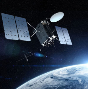
When managed by a new ground control system, GPS III satellites will offer triple the accuracy and eight times the anti-jamming capabilities of the satellites currently comprising the U.S. Air Force’s GPS constellation. Users military and civilian will reap ample benefits.
Everything changed for space-based positioning, navigation and timing around the world on Dec. 23, 2018. Or maybe it didn’t. The innovations heralded by the launch of the first GPS III satellite will take years more to occur. We tabulate here the advances that Generation Three will bring over GPS-to-date, and review the timeline for their actual arrival.
While these new capabilities exist — in concept — in space, they can’t be leveraged on the ground (or in the air, or at sea) until a sufficient number of additional GPS III satellites have joined the constellation, and until a new ground control system comes online. This will occur — perhaps — in 2023. At that time the satellites’ talents will be unleashed.
“As more GPS III satellites join the constellation, it will bring better service at a lower cost to a technology that is now fully woven into the fabric of any modern civilization,” stated Lt. Gen. John Thompson, commander of the U.S. Air Force’s Space and Missile Systems Center and the Air Force’s program executive officer for space.
The many GPS III upgrades should make the service more reliable and accurate for civilians, more secure against those who want to jam military users, and more cyber-secure for everyone.
TALKIN’ ‘BOUT OUR GENERATION
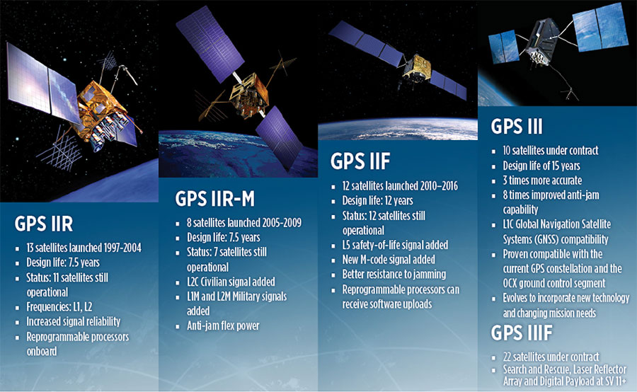
GPS constellations have grown through six major iterations since 1978. The sixth, GPS IIF, rose during the years 2010 to 2016. Those 12 satellites are all designed to last 12 years. Some of their notable features include the ability to receive software uploads, better jamming resistance and increased accuracy.
GPS III, the seventh generation, will launch nine more satellites to join SV01 already in space. GPS III SV02 is scheduled to launch in July of this year, SV03 in late 2019, and SV04 in 2020. The final III payload should rise in 2023. From that point on, the follow-on era of GPS IIIF takes over.
How Long, How Long? “Projections for how long the current constellation will [continue to] be fully capable have increased by nearly two years to June 2021, affording some buffer to offset any additional satellite delays,” reported the Government Accounting Office at the end of 2017. This provided some schedule buffer for launching the first GPS III satellite, but it did not reduce the desire to launch as soon as the booster rocket became available.
The new birds will introduce new capabilities to meet higher demands of both military and civilian users: once filled out, the GPS III constellation will bring three times better accuracy and up to eight times improved anti-jamming capabilities. Spacecraft life requirement will extend to 15 years, 25 percent longer than the latest GPS satellites and twice the original design life of the oldest satellites on orbit today.
The new L1C civil signal broadcast by GPS III is an interoperable signal with other international global navigation satellite systems, like Galileo, improving connectivity for civilian users.
GPS III will eventually actualize full M-code capability — carried aboard the IIR-Ms and IIFs but not yet completely implemented — in support of warfighter operations. GPS III M-code capability exceeds that of GPS IIR-M and GPS IIF.
GPS III will complete the deployment of the L2C civil signal and the L5 safety-of-life signal capabilities that began with \GPS IIR-M and GPS IIF satellites.
Finally, GPS III will enact improved integrity: the ability of the satellite to detect and issue alerts on its own reduced accuracy, should that phenomenon ever occur.
Military Signal Power Up. Encrypted M-code signals will be up to eight times more powerful than currently. This makes them more reliable. but also enables the sats to overcome efforts to jam their signals.
Other signals also offer increased signal power at the Earth’s surface. L1 and L2: −158.5 dBW for aC/A code signal and −161.5 dBW for the P(Y) code signal. L5 will be −154 dBW.
Family Features. The most recent generations of the GPS constellation. IIR, IIR-M and III were produced by Lockheed Martin, while IIF was built by Boeing. One GPS IIA satellite is still in operation, at 25 years young (design life was 7.5 years). All satellites carry Harris Corporation payloads. (Graphic sourced from: Lockheed Martin and Boeing Co.)
L SIGNALS
L2C, the second open GPS signal, after L1 C/A, has been available from every new GPS satellite since the first IIR-M launch in 2005. L5, the third open GPS signal, became available with the first IIF launch in 2010. Now L1C, the fourth open GPS signal, joins the band, broadcasting from every new GPS satellite, starting with the recent GPS III launch (see First Light).
The first GPS III satellite is in checkout and testing that could last up to 18 months before it enters service. “After its Dec. 23 launch, GPS III SV01 successfully completed its orbit raising and deployment of all of its antennas and solar arrays. On Jan. 8, the satellite’s navigation payload began broadcasting navigation signals,” said Johnathon Caldwell, Lockheed Martin vice president for navigation systems. “On-orbit testing continues, but the navigation payload’s capabilities have exceeded expectations and the satellite is operating completely healthy.”
Testing, Testing. Using the Air Force’s Back-to-Basics program, which involved early prototyping and simulations, Lockheed Martin developed GPS III with an approach that involved rigorous quality-build certificates, component testing and system-level testing. The comprehensive requirements verification and validation process ensured more than 30,000 requirements were achieved. The system functional qualification includes the performance verification in multiple environmental tests, including the acoustic, thermal vacuum (TVAC) and electromagnetic spectrum.
“We consider thermal vacuum the gold standard for testing any satellite before it goes into operations,” Col. Steve Whitney, director, GPS Directorate, wrote in GPS World in December. “It really is putting the craft through the paces. When it goes through the testing, the satellite is on. It is working. It is exposing it to the heat and the cold and the zero pressure while the satellite is functional. The entire thermal vac testing from start to end is about 70 days. Test like you fly. From the time it launches and deployment sequence, we test it like it is real. Minus the shaking, the satellite thinks it is getting launched. Meanwhile, our people are looking at the data and its health. TVAC is a huge milestone for a satellite to go through and come out no issues.”
To date, more than 90 percent of parts and materials for all 10 GPS III satellites have been received from more than 250 aerospace companies in 29 states.
BRAIN OF THE BUNCH
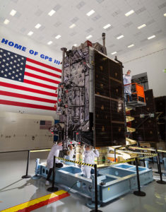
THE FIRST GPS III satellite was fully assembled and entered into SV single-line flow when Lockheed Martin technicians integrated its system module, propulsion core and antenna deck. (Photo: Lockheed Martin)
Harris Corporation is a subcontractor to Lockheed Martin for development and production of GPS III Mission Data Units (MDUs) and transmitters for the GPS space section. Six have been delivered.
The Harris MDU, together with the Atomic Frequency Standards and the L-band transmitter equipment, make up the Navigation Payload Element. The MDU performs the primary mission of the GPS satellite: generation of the navigation signals and data on a continuous basis. The MDU controls the generation of the precise timing signals used for navigation signals while distributing the timing signals to other satellite components.
This MDU is 70 percent digital. The next to come, aboard GPS IIIF satellites, will be fully digital.
When asked about the advantages of an all-digital payload, Harris Corporation’s Jason Hendrix, PNT program director, told GPS World in April 2018, “The advantages and the 30 percent difference are the timekeeping system portion. We’re moving from manual, analog timing to digital to deliver to the Air Force more flexibility. It’s a nice option to have to be able to reprogram in orbit and maybe enhance capabilities desired in the future.”
LIVING BETTER, LIVING LONGER
Greater mission longevity is one of the key improvements GPS III delivers over those currently in service. Space Vehicles 1–10 have a planned mission life of 15 years, 25 percent longer than their predecessors. That begs the question, “How long should a satellite live in space, with technology innovation occurring almost annually?”
Advanced payload technology provides a partial answer. Lockheed Martin and Harris point to new payload capabilities with built-in flexibility to adapt satellites in orbit to technology advances, as well as changes in missions. According to Harris, the fully digital navigation payload will provide the ability to change and upgrade the satellites incrementally over mission life.
In late 2017, Lockheed announced a partnership with NEC Corporation to introduce artificial intelligence for computer learning in orbit. The company touted significant advances in processors and a move toward next-generation antennas, arrays and transmitters to drive more satellite flexibility, capability and resilience.
FROM THE GROUND UP
GPS IIIF’s M-Code can be broadcast from a high-gain directional antenna in a concentrated, high-powered spot beam, in addition to a wide-angle, full-Earth antenna. (Artist rendering: Lockheed Martin)
GPS III’s military upgrades require new ground control stations, a replacement effort called OCX that has suffered repeated delays and cost increases, due to the complexity of the programming and requirements modifications. The new jamming-resistant military signal will not be available until the new, highly complex ground control system is available, and that is not expected until 2022 or 2023. Delay and cost considerations were driven in part by full implementation of all Department of Defense 8500.2 “Defense in Depth” information assurance standards without waivers, giving it the highest level of cybersecurity protections of any DoD space system.
Deliverables for GPS OCX are divided into three blocks. Block 0 delivery took place in fall 2017, enabling it to support the December launch. Block 1 delivery will take place in 2021, providing full operational capability to control both legacy and modernized satellites and signals. Block 2, delivered concurrently with Block 1, adds operational control of L1C and modernized M-code.
In 2018, wrote Col. Whitney of the GPS Directorate, “We have actively utilized the [Block 0] system in a variety of exercises, training events, compatibility tests and launch readiness events. We also completed a comprehensive security review of the system to demonstrate our readiness to start operations. The system is ready to go. We continue to work the development of the OCX Block 1 system and are wrapping up the initial coding of the system early in 2019, leading into our integration and test campaign.”
Given delays in OCX, “the Directorate is actively working two major upgrades to bridge the gap,” Whitney continued. “The first is GPS III Contingency Operations (COps) modification which will allow the 2nd Space Operations Squadron (2SOPS) to command and control the GPS III family of vehicles in a mission state matching today’s legacy signals for all users world-wide. The second modification is M-code early use (MCUE), which enables 2 SOPS to operationalize the Modernized GPS military (M-code) navigation signals for the warfighter.”
Before December’s launch, OCX underwent rigorous cybersecurity vulnerability assessments that tested the system’s ability to defend against both internal and external cyber threats. GPS OCX prevented the broadcast of corrupt navigation and timing data in all tests, bolstering the program’s readiness for GPS III.
“We’ve built a layered defense and implemented all information assurance requirements for the program into this system,” said Dave Wajsgras, president of Raytheon Intelligence, Information and Services. “The cyber threat will always change, so we’ve built OCX to evolve and to make sure it’s always operating at this level of protection.”
The new Harris navigation payload offers a smooth transition to use of OCX. The payload for the first 10 GPS III satellites has been verified for OCX compatibility so the same OCX commands will seamlessly port to the Harris fully digital design, minimizing integration risks and associated costs.
According the the GAO, “Full M-code capability —which includes both the ability to broadcast a signal via satellites and a ground system and user equipment to receive the signal — will take at least a decade once the services are able to deploy military GPS user equipment (MGUE) receivers in sufficient numbers.” The April 2019 issue of GPS World will review M-code implementation across U.S. DoD platforms.
THE FUTURE’S NOT OVER YET
In spring 2018, Lockheed Martin submitted a proposal for the GPS III Follow On (GPS IIIF) program, which will add enhanced capabilities to the satellites. New hardware — a high-gain directional antenna — aims signals in a spot beam at a limited area, but blasts the signal at high power for strategic use by the military.
Inter-Satellite Links. Block IIIF satellites will carry laser retro-reflectors to enable orbit tracking independently of the satellites’ radio signals, which in turn will allow satellite clock errors to be disentangled from ephemeris errors. A standard feature of GLONASS, this is included in the Galileo positioning system, and was flown as an experiment on two older GPS satellites, 35 and 36.
In September 2018, the Air Force selected Lockheed Martin to build up to 22 additional satellites under the GPS IIIF program.
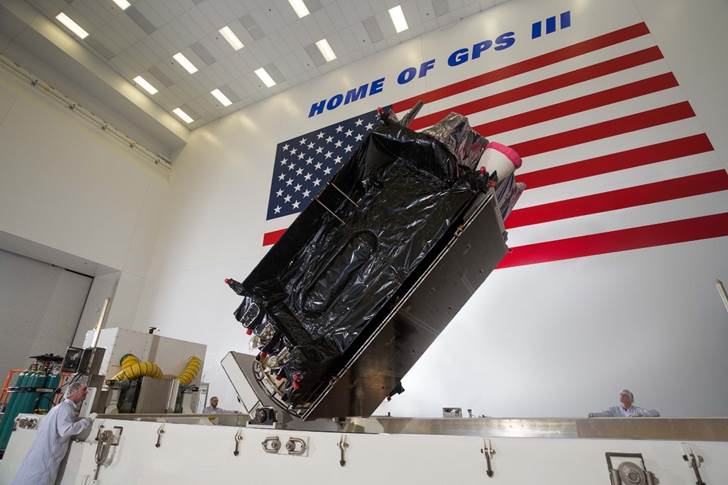
The U.S. Air Force’s second new GPS III satellite, bringing higher-power, more accurate and harder-to-jam signals to the GPS constellation, has arrived in Florida for launch.
On March 18, Lockheed Martin shipped the Air Force’s second GPS III space vehicle (GPS III SV02) to Cape Canaveral for an expected July launch.
Designed and built at Lockheed Martin’s GPS III Processing Facility near Denver, the satellite traveled from Buckley Air Force Base, Colorado, to the Cape on a massive Air Force C-17 aircraft. The Air Force nicknamed the GPS III SV02 “Magellan” after Portuguese explorer Ferdinand Magellan.
GPS III is the most powerful and resilient GPS satellite ever put on orbit. Developed with an entirely new design, for U.S. and allied forces, it will have three times greater accuracy and up to eight times improved anti-jamming capabilities over the previous GPS II satellite design block, which makes up today’s GPS constellation.
GPS III also will be the first GPS satellite to broadcast the new L1C civil signal. Shared by other international global navigation satellite systems, like Galileo, the L1C signal will improve future connectivity worldwide for commercial and civilian users.
The Air Force began modernizing the GPS constellation with new technology and capabilities with the December 23, 2018 launch of its first GPS III satellite. GPS III SV01 is now receiving and responding to commands from Lockheed Martin’s Launch and Checkout Center at the company’s Denver facility.
Lockheed Martin shipped the U.S. Air Force’s first GPS III to Cape Canaveral, Florida ahead of its expected July launch. (Photo: Lockheed Martin}
“After orbit raising and antenna deployments, we switched on GPS III SV01’s powerful signal-generating navigation payload and on Jan. 8 began broadcasting signals,” Johnathon Caldwell, Lockheed Martin’s Vice President for Navigation Systems. “Our on orbit testing continues, but the navigation payload’s capabilities have exceeded expectations and the satellite is operating completely healthy.”
GPS III SV02 is the second of ten new GPS III satellites under contract and in full production at Lockheed Martin. GPS III SV03-08 are now in various stages of assembly and test. The Air Force declared the second GPS III “Available for Launch” in August and, in November, called GPS III SV02 up for its 2019 launch.
In September 2018, the Air Force selected Lockheed Martin for the GPS III Follow On (GPS IIIF) program, an estimated $7.2 billion opportunity to build up to 22 additional GPS IIIF satellites with additional capabilities.
GPS IIIF builds off Lockheed Martin’s existing modular GPS III, which was designed to evolve with new technology and changing mission needs. On September 26, the Air Force awarded Lockheed Martin a $1.4 billion contract for support to start up the program and to contract the 11th and 12th GPS III satellite.
Once declared operational, GPS III SV01 and SV02 are expected to take their place in today’s 31 satellite strong GPS constellation, which provides positioning, navigation and timing services to more than four billion civil, commercial and military users.
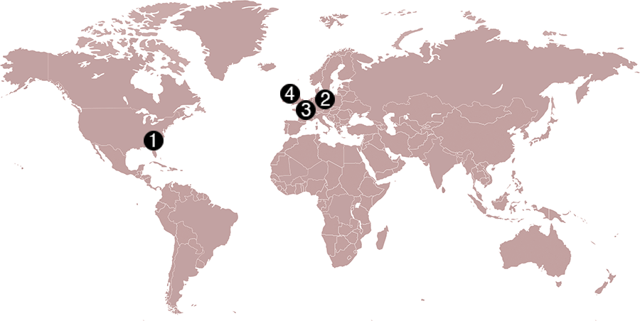
Check out some GPS developments that have recently taken place around the world. (Click to enlarge; Map: iStock.com/nadla)
1. When horses answer the call
Taking a ride in a horse-drawn carriage delights many visitors to historic Charleston, South Carolina. Until now, city crews cleaning up the presents horses leave behind have relied on flag indicators left by carriage operators. Now the city is testing a new method. Carriage operators will send the exact location to equine sanitation crews using small GPS-enabled devices. When a horse or mule takes an on-street nature break, the guide presses a button, and the equine sanitation crew is notified of exactly where to go. When the cleanup is complete, the notification is deleted.
2. Detecting rain over the ocean
Despite a wide variety of monitored geophysical parameters, GNSS signals reflected off the Earth’s surface (GNSS reflectometry) have never been used to obtain rain information. A new study presents evidence that data from the U.K.’s TechDemoSat-1 potentially enables the GNSS-R technique to detect precipitation over oceans at low winds. The study — by scientists at the GFZ German Research Center for Geosciences at Potsdam — could serve as a starting point for developing a new GNSS reflectometry application, which might also be implemented for low-cost GNSS remote-sensing missions.
Click to enlarge. (Photo: Chocolateam)
3. Gaming with Galileo
Gamers around the world can now play with the Galileo constellation. Callisto for Android uses Galileo signals in a virtual maze game based on walking through a real-world location. Looking down on Earth as if from a spaceship, players use a Google Map display to traverse an area filled with randomly generated obstacles and collectibles. The project began as an entry to European Space Agency’s Galileo App Competition 2017–2018 and was one of three apps that made it to the finals.
4. Guinness decision pending on world’s steepest street
Dunedin, New Zealand, claims to have the world’s steepest street (Baldwin), a title officially challenged in January by the town of Harlech, Wales, when residents walked up and down the narrow, winding Ffordd Pen Llech carrying a GNSS surveying receiver. A total of 14 data points were recorded on the 330-meter-long road, which had an altitude accuracy of ±5 centimeters. New Zealand surveyor Richard Hemi said the GNSS method used by the Welsh group might not be accurate. Best accuracy is to survey from the center of the road — easy on Baldwin St. but much more difficult on a winding lane. The survey was sent to Guinness World Records, which will issue a decision this spring.
The Coast Guard Navigation Center has published a special notice to mariners that use GPS equipment. The special notice outlines the details of the GPS Week Number Rollover that will occur April 6-7.
To best prepare for the rollover event, users of GPS equipment who are concerned should update their firmware, or contact their equipment manufacturer to ensure their equipment is ready for this event.
When the week number reaches 1024 at 18 seconds before midnight (UTC) on April 6, it will reset to zero as it keeps counting. This has happened once before, in August 1999.
Recent devices have likely been designed to handle the rollover event.
Older GPS receivers, however, or receivers that have not been provided manufacturer updates, may be affected by the rollover. The impact might occur in April, or could affect such equipment at a later date. The date might revert back to August 1999, or may revert to another date. Since this issue does not affect the other parts of the GPS navigation message (it only affects the date), the receiver’s ability to calculate the position and to display the exact time of day should not be impacted.
Additional information about GPS and the GPS Week Number Rollover is available here:
Civil GPS users are encouraged to report disruptions or anomalies to the U.S. Coast Guard Navigation Center or via phone at 703-313-5900, 24 hours a day.