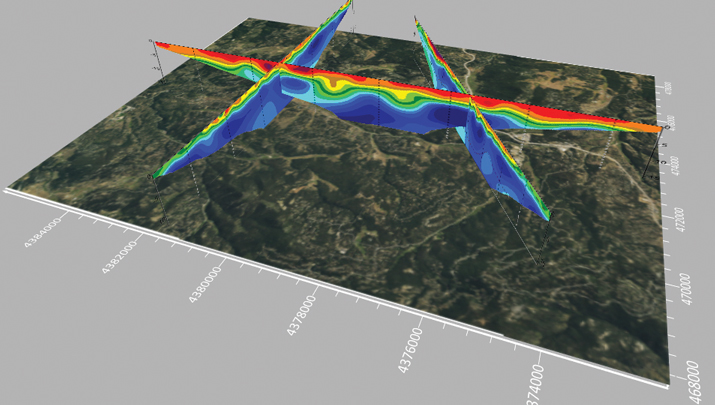
Point cloud and 360-degree image collected with the Leica Pegasus: Two Ultimate. (Photo: Leica Geosystems )
The latest mobile mapping innovations are transforming how we manage, design and monitor our critical infrastructure — in particular, reshaping road maintenance. Through the advance of mobile mapping and reality capture imagery, our ability to map, proactively survey and even design roads, from simulating the vibration of a vehicle on a road to mapping out city routes, is drastically improving through the symbiosis of the digital and physical worlds.
Leveraging data: Traditional vs autonomous mapping
Traditional methods for assessing damage to road surfaces are highly manual, field-based, labor-intensive and time-consuming. Visual inspection, for example, comes with resourcing challenges, data exhaustivity and inaccurate assessments, making quality assessment and control a challenge. There is limited accurate analysis of how the road changes over time, and the work involves significant safety issues, with surveyors required to work in the field near live traffic and often requiring the traffic to be interrupted to allow measurements to be taken.
By contrast, automated laser scanning solutions provide spatial geometry for precise measurements that imagery-only methods cannot capture when assessing damage to road surfaces. They overcome any inaccuracies or lack of detail regarding location and circumstances. This technology also allows professionals to study the surrounding context of the road and measure the depth of a hole or the size of a crack with spatial data, which visual methods cannot capture. Hexagon’s mobile mapping systems, used for virtual road management and maintenance, enable access to a completely virtual environment to unlock the insights this data provides, transforming how we manage our infrastructures. With spatial data collected over time, asset degradation and other factors foundational to maintaining road infrastructure can be predicted by the more effective leveraging of data.
With geospatial data allowing the accurate mapping of potholes, rutting and depressions alongside accurate location mapping using GIS, asset managers can map the data onto real-world imagery to create an interactive, 3D model integrating the physical world and geospatial data. Combined, this unlocks insights and overhauls efficiency for asset managers performing road maintenance, allowing them to prioritize and make decisions based on data live in the field.
Veris deploys Hexagon’s solutions for road mapping
Recently, Hexagon’s technology was used by Veris, a provider of spatial data services to deliver end-to-end solutions for road management and maintenance in Australia. It combined a Leica Geosystems mobile mapping system, the Leica Pegasus:Two Ultimate, with Hexagon M.App Enterprise to create a high-quality, configurable solution and designed its own bespoke software platform RoadSiDe.
Veris used the mobile mapping system on the Hume and Melba Highways to identify and assess road defects and ground penetrating radar (GPR) to rapidly perform data capture of the road corridor. Then, RoadSiDe analytics and machine learning enabled the delivery of the data and insights using M.App Enterprise and Luciad Fusion, integrating 3D visualizations and 2D dashboards to identify, assess and quantify the road condition as part of the only full 3D road condition and corridor platform. The in-house solution for scripts and automation Veris developed made it simple for their clients to visualize and interact with the data, providing analytics and value-added services on demand that offered valuable insights for its clients.
As part of the surface defects workflow they use for analysis, Veris takes the raw point cloud data and compares it with the ideal road exterior to create a surface difference model, followed by contours and improved defect definition. This cross-comparison and integration allows them to use and visualize the data they acquired by precisely measuring the gaps and holes. Veris efficiently captured road cracking in detail with its additional 12MP/20MP camera system. These are then mapped into the RoadSiDe dashboard, and cracking width and length are captured within the geodatabase. Machine learning is used to detect cracks in the road surface before pixels are classified into clusters and projected onto the original images for verification and quality assurance. This can then be integrated with location coordinates, allowing clients to see precisely where each cracking is located. With this georeferenced data digitized and visualized, Veris can leverage as much of its data as possible into the most effective platform for its users.
Expanding the scope of mobile mapping
The data captured by mobile mapping solutions is just as helpful in designing roads as in maintaining them and can be incorporated into the construction of future roads and city planning. The data even can be used to simulate, for example, the movement of a heavy truck through city streets to examine whether it will impact potholes or damage any road signs, allowing asset managers to predict and prevent damage and maintain road infrastructure for years to come.
A roundup of recent products in the GNSS and inertial positioning industry from the May 2024 issue of GPS World magazine.
SURVEY & MAPPING
Photo: Virtual Surveyor
UAV With planimetric survey capabilities
The Virtual Surveyor version 9.5 now allows users to quickly and accurately survey 2D features from UAV orthophotos and add them to the 3D topographic model generated from the same data set.
True 2D features, for example, include the paint striping that delineates parking lot spaces and road lanes. Other objects that exist in 3D on the ground but can be surveyed in two dimensions include building footprints and tree canopies. These features are designed to offer a new level of efficiency to the UAV surveying process in Virtual Surveyor.
Virtual Surveyor provides users with an end-to-end workflow to conduct 3D surveys from UAV imagery. The integrated Terrain Creator app photogrammetrically processes UAV photos to build survey-grade digital surface models (DSMs) and orthomosaics. No third-party software is needed to create surveys from UAV data. The system is ideal for users in construction, surface mining and excavation projects.
Positioning System Incorporates an anti-jamming and interference monitoring system
SXblue GLOBE merges GNSS and GIS to deliver positioning accuracy, efficiency and reliability in challenging field conditions using a 448-channel GNSS board.
Its advanced multipath mitigation aims to reduce the effects of signal reflection and ensure the integrity of positioning service, even in GNSS-challenged environments. The SXblue GLOBE incorporates an anti-jamming and interference monitoring system, safeguarding against disruptions and offering uninterrupted operation in any scenario.
The system uses global or local coverage of correction services, satellite-based augmentation system (SBAS), and real-time kinematics (RTK) with an update rate of up to 100Hz. This seeks to provide users with enhanced accuracy and reliability in positioning activities. Sxblue GLOBE features a Wi-Fi connection, which allows its parameters to be easily configured via a web user interface.
3D Mapping Software With expanded visualization tools
The Surfer mapping and 3D visualization software now features upgraded 3D visualization capabilities. The upgrades are designed to give users a complete picture of collected subsurface data. The expanded visualization tools in the latest Surfer version make it easier to create 3D grid files for viewing and analysis of drillhole data.
Surfer can be used for environmental consulting, water resources, engineering, mining, oil and gas exploration and geospatial projects.
With these upgrades, users can render 3D grids as a series of blocks, which can be colorized by a select variable. Images of cross sections, profiles and other features can be imported directly into 3D View and oriented in any direction or angle. To isolate certain features in the 3D grid, users can assign NoData to portions of the grid with a variety of methods. This allows users to eliminate unwanted data in a 3D grid outside of field boundaries, well locations, or above or below specific surfaces, such as a water table, topography, or lithologic layer.
Digital Twin Platform Shows roadway incidents in real time
The Flow RT is a real-time digital twin platform designed to provide agencies with instantaneous alerts and insights for better decision-making. The platform allows traffic managers to view traffic conditions, signal operations and roadway incidents in real time, at scale across entire regions.
Flow RT integrates seamlessly with the company’s solutions, including traffic signal management, roadway safety management and mobility management. Powered by connected vehicle data from industry-leading partners, including TomTom, the platform offers up to five times higher vehicle data penetration rate than the previous industry standard. Flow RT also provides alerts and notifications while offering data-driven decision support, ensuring agencies can make the best decisions using the most accurate, reliable and instantaneous insights with and without infrastructure connectivity.
INS With an integrated acoustic resonance air speed sensor
Inertial Labs has integrated the FT Technologies FT743-D-SM acoustic resonance air speed sensor into its inertial navigation systems (INS).
This integration aims to improve the accuracy of horizontal air speed estimation for multi-rotor UAVs, even in GNSS-denied environments. The FT743-D-SM airspeed sensor is a digital anemometer-based solution that can estimate airspeed incoming from any direction using acoustic resonance technology, which is immune to vibration and external acoustic noise. The airspeed magnitude and direction allow the INS to estimate horizontal air speed in the longitudinal and lateral axes.
The INS receives aiding data from the dual-axis airspeed sensor and experiences significantly less position drift compared to a dead reckoning alternative in GNSS-denied environments, the company said. The system can be used in mission-critical roles in multiple military or defense applications, as well as in civilian applications such as wind energy, marine navigation, UAVs and dynamic positioning systems.
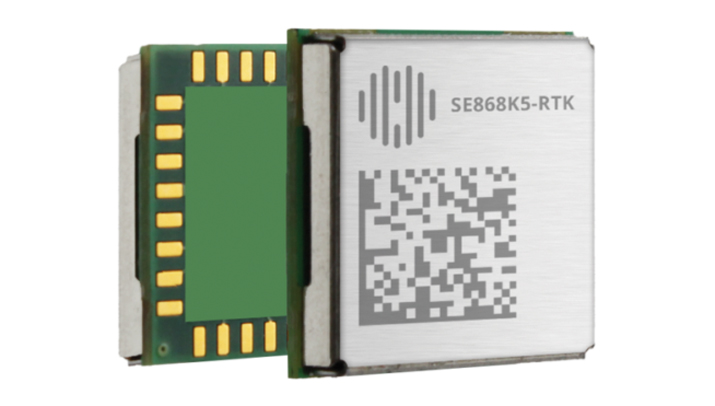
The SE868K5-RTK module is a GNSS receiver capable of centimeter-level accuracy. It is designed for seamless operation near cellular or other radios and is suitable for precision applications.
At 11 x 11 mm, the module’s compact form factor offers adaptability in size-constrained scenarios and easy migration within the xE868 product family. It is designed to offer high-performance navigation, even in challenging RF conditions. The solution can be integrated into applications such as wearables, UAVs, robots, fleet tracking and precision agriculture.
The SE868K5-RTK is a multifrequency and multi-constellation positioning receiver module with RTK capabilities that enhance positioning accuracy. By harnessing dual frequencies — L1/E1 and L5/E5 — the module offers improved location precision and reduces multipath effects.
In partnership with Swift Navigation, the SE868K5-RTK module utilizes local base stations or Swift’s Skylark precise positioning service for corrections, which offers reliable centimeter-level accuracy across an extensive coverage area. The integration and Telit Cinterion’s cellular modules and NExT connectivity services offer continuous and accurate correction data delivery to the GNSS module.
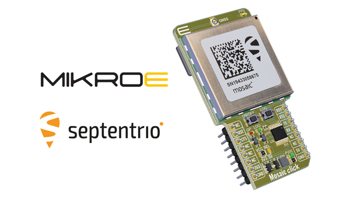
Upgraded Click Board Now with an integrated GNSS receiver module
The Septentrio mosaic-X5 GNSS receiver has been integrated into the MikroElektronika (MIKROE) Mosaic Click board.
Mosaic Click is compatible with mikroBUS socket standard, allowing plug-and-play prototyping and reduced time-to-market. The mosaic-X5 receiver uses triple-band GNSS technology to achieve centimeter-level RTK accuracy, even in challenging environments. Its anti-jamming and anti-spoofing technology protects the receiver from malicious or accidental radio interference. It is ideal for applications where safety is a concern, as well as autonomous and mission-critical applications of systems such as UAVs or industrial robots.
The mosaic-X5 receiver tracks all available GNSS constellations and is protected by Septentrio’s AIM+ anti-jamming and anti-spoofing technology. Full GNSS raw data and positioning are delivered at a high update rate of 100Hz and with low latency, which is critical for autonomous movement and maneuvering.
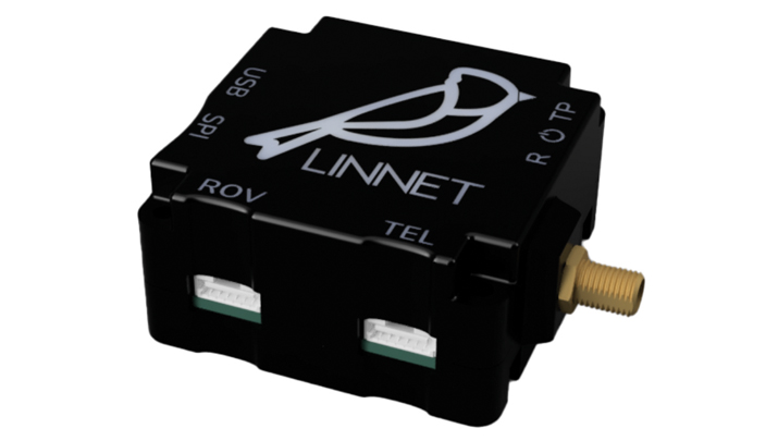
RTK Positioning Module Supports all GNSS constellations
The Linnet mosaic-X5 is a multi-band module featuring the Mosaic-X5 receiver by Septentrio. It receives signals from all major constellations and can be used both directly on the rover and as a base station. The system can achieve centimeter-level positioning accuracy and attain precise positioning even in low-coverage zones and harsh vibrations and shocks.
The mosaic-X5 module is a 448 channels all-in-view receiver that supports all GNSS constellations, SBAS and QZSS, as well as built-in on-module support for other L-band correction services. The Linnet Mosaic-X5 features anti-jamming protection and anti-spoofing built-in and embedded spectrum analyzer.
The module can be used in a variety of applications, including tracking, surveying, autonomous navigation, ground robotics, precision agriculture and machine control.
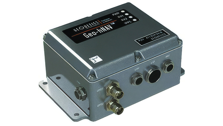
Geo-hNAV is a rugged, hybrid dual-GPS-aided INS. It offers consistent position and attitude measurement accuracy whether the platform is static or moving. The Geo-hNAV combines the Geo-iNAV INS with the Geo-Pointer dual-antenna heading system.
For stationary or slowly moving platforms, precise heading is derived from GPS measurements using two GPS antennas rigidly mounted on the platform, separated by a typical distance of 1 to 3 meters. In dynamic conditions, the combination of GPS and IMU seeks to provide enhanced position, velocity and attitude measurements. The system can be used for geo-positioning onboard sensors on static, low and high dynamic platforms such as aerostats, boats and tanks.
The C631 is a multi-GNSS, multi-frequency smart antenna. The C631 provides robust performance and high precision in a compact and rugged package. With multiple wireless communication ports and an open GNSS interface, the C631 can be used in a variety of operating modes.
C631 can be used as a precise base station sending RTK to existing rover networks. Users can turn the C631 into a lightweight rover by connecting it to a base via UHF radio or Wi-Fi network. The built-in web user interface can be used to control and manage the receiver status and operation and upgrade the C631 with new firmware and activations.
Atlas is a global correction service that can be added as a subscription to the C631. Atlas delivers worldwide centimeter-level correction data over L-band communication satellites.
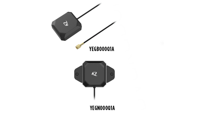
The YEGB000Q1A and YEGN000Q1A active GNSS L1 and L5 antennas are designed to tap into L1 and L5 frequency bands for advanced navigation applications. These antennas, operating within the 1164-1189 MHz and 1559-1606 MHz frequency bands, are designed to support a variety of installation methods, catering to diverse application needs with options for screw mount, adhesive mount, magnetic mount and various cable connections.
The antennas are part of a broader release that includes the YEMN016AA and YEMN017AA 5G 5-in-1 combination antennas, which also feature GNSS capabilities.
These GNSS antennas are crucial for applications that require high levels of navigation accuracy, such as autonomous vehicles, UAV delivery systems and precision farming.
The TW5387 industrial-grade smart GNSS antenna integrates the Quectel ST TESEO V GNSS receiver chipset onto the Calian compact smart GNSS antenna platform. It is designed to offer dual-band GNSS, eXtended filtering, low phase center variation, low signal-to-noise ratio and dual feed and patch for strong multi-path rejection.
The TW5387 comes with RTK rover capability and a built-in IMU for sensor fusion. It is designed to minimize RF impairments that affect the performance of the GNSS receiver and provide GNSS coordinates to the host system over a robust digital interface for noise resilience.
TW5387 is suited for automotive, UAV, robotics and defense applications that require high precision location and timing. TW5387 is compatible with N-RTK correction services such as Point One Navigation’s Polaris and Swift Navigation’s Skylark. It tracks GPS, Galileo, BeiDou and L1/L5 band operation and is housed in an industrial-grade IP69K enclosure.
The PEANGPS1005 is an active GPS/GNSS multi band L1/L2/L5 antenna with 47.5 dBi overall gain. It is IP69K rated, light weight and designed for surveying. This GPS/GNSS antenna is suited for harsh operating environments where stability and reliability of GPS/GNSS signal is required.
This antenna operates in the 1.164-1.3GHz and 1.525-1.615GHz bands, meeting GPS L1/L2/L5, GALILEO E1/E6/E5a/E5b and GLONASS L1/L2/L3 requirements. The PEANGPS1005 antenna has an integrated LNA with 2 dB noise figure and LNA gain of 40 dB.
The antenna has an axial ratio of 3 dB and can track visible satellites under extreme conditions, which is ideal for UAV navigation, autonomous tracking or GIS surveying.
Paving and Mining Solution Meets DOT smoothness standards
The MC-Max asphalt paving and MC-Max milling solutions offer modularity, simplified configurations and advanced feature sets to increase productivity in asphalt paving and cold milling applications.
The MC-Max Asphalt Paving and MC-Max Milling systems, which are made up of , total stations, displays and other high-precision sensors, are built with the new MC-X machine control platform. Users can choose from entry-level 2D systems that follow a reference, such as a string or a curb, or automated solutions that track a paver or miller in 3D.
Contractors can pave and mill at variable depths while meeting smoothness standards mandated by the U.S. Department of Transportation (DOT) smoothness standards. The solutions also include MC-X licensing options. The technology is compatible with OEM CAN-based systems and has expanded to include compatibility with additional aftermarket systems.
It is equipped with Topcon Virtual Ski intelligence software designed to simplify workflows in specific resurfacing applications, such as rural roads where there are fewer fixed points or intersections to match up to.
Reality Capture Platform Generates detailed 2D and 3D models
This UAV reality capture platform collects data through FlytBase UAVs and generates detailed 2D and 3D models on SkyeBrowse, a UAV reality capture platform.
The platform uses SkyeBrowse’s videogrammetry technology to quicly convert UAV video footage into 2D maps and 3D models, making it ideal for emergency response scenarios where rapid documentation is critical. The platform integrates seamlessly with beyond visual line of sight (BVLOS) systems, enhancing both the speed and quality of data-driven strategies in critical operations.
The E400 fixed-wing VTOL ISR UAV now features a 360° camera option. Partnering with NextVision, the Event 38 UAV now offers a range of EO/IR Gimbal camera options for seamless integration with the E400 platform.
NextVision’s gimballed EO/IR cameras capture visual and thermal imagery and video. The UAV provides live streaming directly to ground stations for continuous monitoring capabilities.
The 360° EO/IR camera integrated onto the E400 ISR can be used for search-and-rescue missions, suspect pursuit, emergency management and disaster response. The E400 ISR, built with a military-grade carbon fiber frame, offers durability for rugged field applications and allows for extended flight durations without the need for frequent recharging. It is suited for surveillance and security applications. It features electric propulsion and minimal noise emissions for discreet flight operations.
Enhanced BVLOS System Offers situational awareness to UAS operators
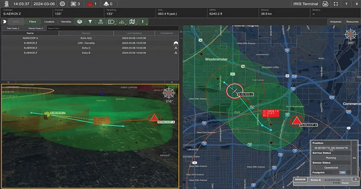
IRIS Terminal now features Echodyne radar technology designed to enhance Beyond Visual Line of Sight (BVLOS) operations for unmanned aerial systems (UAS) in Advanced Air Mobility (AAM) applications.
The integration seeks to provide situational awareness to UAS operators by visualizing all airspace movement, cooperative and noncooperative, to ensure safe and reliable UAS operations.
IRIS Terminal, now in its second generation, has been adapted from its defense origins to the enterprise UAS sector for visualizing airspace traffic, as well as controlling uncrewed systems in its GCS format. Airspace traffic is visualized inside IRIS Terminal’s multiple viewing configurations, along with features such as detect-and-avoid (DAA) sensor footprints, terrain awareness and potential conflict warnings.
The Inertial Labs’ RESEPI lidar remote sensing payload instrument GEN-II has been integrated into Sony’s Airpeak UAV.
The partnership seeks to enhance Airpeak’s ability to produce detailed aerial maps and 3D models.
Tailored for professionals, the lidar system integrated into Sony’s Airpeak UAV will significantly enhance workflow efficiency and data accuracy, particularly in sectors such as construction, agriculture, and filmmaking, according to Inertial Labs. The system allows for extensive data handling and facilitates longer durations of data collection without frequent offloads. The UAV can be used for surveying, mapping and cinematic videography.
Emlid has launched the Pix4D & Emlid Scanning kit. The kit combines advanced photogrammetry with real-time kinematics (RTK) precision for quick data capture when documenting trenches and as-builts, performing volumetric measurements and enhancing aerial data with terrestrial scans. It includes the PIX4Dcatch app and the Emlid Reach RX RTK rover.
The PIX4Dcatch app is at the core of the kit’s software, which allows precise scanning for both photogrammetry and lidar projects. The hardware part features the Emlid Reach RX RTK rover, which is equipped with an ergonomic handle and accessories.
It is integrated with PIX4Dcatch and provides real-time positioning via NTRIP. To begin scanning, users can select Emlid in the RTK settings of PIX4Dcatch and add their NTRIP network credentials.
The kit works with any correction network (NTRIP) or a GNSS base station broadcasting RTCM3. The rover gets a fix in less than five seconds, offering centimeter-accurate positioning in challenging conditions. Apart from the scanning tasks, it can be used with the survey pole as an RTK rover for data collection and stakeout.
Designed for urban surveying, the Reach RX rover is lightweight, rated IP68, sealed and protected from water and dust and features an industrial-grade battery, which offers 16 hours of work on a three-hour charge.
The solution does not require additional setup or surveying skills. It is designed for professionals and non-surveyors in a range of applications, including underground utility documentation, construction inspection, volumetric measurements, crash reconstruction and combined aerial and terrestrial surveys.
The PIX4Dcatch mobile app allows users to use a smartphone for scanning, access RTK precision data through integration with Reach RX and generate a digital model within minutes. Users can also store, annotate, measure and share data online in PIX4Dcloud as well as verify geolocated positions and visualize the project in AR. It extracts insights from both terrestrial and aerial data and features online and offline processing, advanced photogrammetry capabilities, team collaboration and AR for CAD overlays.
ipoque, a Rohde & Schwarz company and provider of deep packet inspection (DPI) software for networking and cybersecurity solution providers, has entered a technology partnership with XipLink, a global technology that provides optimized, secure and intelligent multi-path hybrid networking.
Under the partnership, ipoque will integrate its DPI technology, R&SPACE 2, into the XipLink operating system (XipOS) to create the XipLink Application Classification Engine (XipACE). This technology is designed to deliver advanced application visibility for multi-orbit networking.
Layer 7 visibility for multi-orbit networking
Using standards-based space communications protocol specifications (SCPS) protocol acceleration, link bonding, Layer 2 switching and Layer 3 routing, XipLink offers intelligent multi-orbit networking that ensures network performance and quality of service QoS across satellite, cellular and wireless networks. Embedding the next-gen DPI software R&SPACE 2 introduces traffic visibility up to Layer 7 and beyond, powering the traffic aggregation and optimization algorithms used by XipLink.
R&SPACE 2 combines behavioral, statistical and heuristic analysis with metadata extraction to identify protocols, applications and application attributes in real time.
“Our breakthrough AI-based encrypted traffic intelligence, which includes machine learning and deep learning techniques, and high-dimensional data analysis, brings traffic awareness to the next level by identifying any type of IP traffic, despite encryption, obfuscation and anonymization,” said Martin Mieth, P.hD., vice president of engineering at ipoque.
Offers high-performance networks
By integrating R&SPACE 2, XipACE can augment quality of service (QoS) management, traffic analytics, steering decisions, load balancing and dynamic link bonding. R&SPACE 2 also features an extensive feature and plug-in set, such as first packet classification, customizability of app signatures or tethering detection.
Insights from R&SPACE 2 allow XipOS to support network diversity and resilience, from offloading traffic from congested pathways to tapping into GEO satellites to alleviate latency issues. At the policy level, it enables application prioritization and SLA compliance.
As more and more applications require high bandwidth and low latency, the granular traffic analytics offered by R&SPACE 2 can help users optimize their networks and improve resource efficiency. These insights seek to lay the foundation for autonomous and self-healing networks through data-driven decision-making.
The technology is designed for mobile, satellite, maritime, government and defense sectors, as well as modem OEMs.
A roundup of recent products in the GNSS and inertial positioning industry from the April 2024 issue of GPS World magazine.
SURVEYING & MAPPING
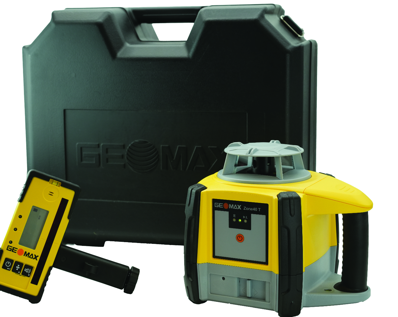
Rotating Laser Built for challenging worksites
The Zone40 T one-button rotating laser is designed for all types of grading and leveling jobs. It seeks to address the industry’s need for efficient and accurate alignment solutions.
Its one-touch operation is designed to simplify and increase efficient workflows in a variety of jobs such as grading, paving, excavating, surveying, layout and more. It is ideal for contractors, crew chiefs, supervisors and trade professionals.
GeoMax products are tested and proven to endure the toughest conditions. With an IP67 environmental rating, the Zone40 T accurately delivers in dust, water, wind and extreme temperatures. GeoMax Positioning, geomax-positioning.com
Hydrographic Surveying Solution With advanced inertial sensors
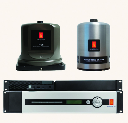
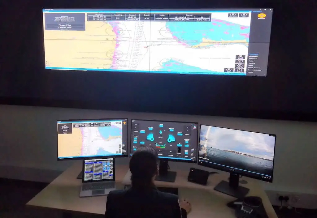
The Seapath 385 navigation system is designed to enhance precision in hydrographic surveying by using advanced navigation algorithms and integrating a range of satellite signals, including GPS, GLONASS, Galileo, BeiDou and QZSS, alongside geostationary satellite signals. The Seapath 385 system combines raw inertial sensor data from Kongsberg Discovery’s high-performance motion gyro compass (MGC) or motion reference unit (MRU) with GNSS data and corrections from real-time kinematics (RTK), precise-point positioning (PPP) or Differential Global Navigation Satellite System (DGNSS). The integration offers a robust and accurate navigation solution ideal for hydrographic surveying.
The system’s dead reckoning capabilities are attributed to its advanced inertial sensors and updated navigation algorithms. It uses GNSS antennas for both positioning and heading determination designed to add an extra layer of robustness to the system. The Seapath 385 also introduces a new post-processing format that consolidates all necessary data and system configurations into a single file, which allows for centimeter-level position accuracy through either satellite orbit and clock data or data logged from base stations.
Designed for ease of installation and continuous, reliable operation, the Seapath 385 is a modular system with a processing unit that handles all critical computations independently of the user interface on the HMI Unit. This feature offers precise measurements with a data rate of up to 200 Hz at multiple monitoring points, which makes it an ideal solution for accommodating sensors or systems that depend on motion or position data throughout the vessel. Kongsberg Discovery, Kongsberg.com
Marine-Grade Sensor Compatible with USVs
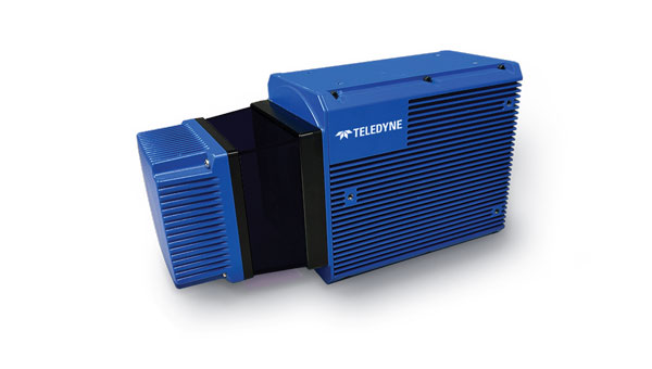
The Optech CL-360 Marine is a 360° long-range laser scanner. It combines a scan speed of 250 lines per second with 2 mm range resolution, a plug-and-play solution and an IP67 marine-grade sensor.The system can be seamlessly integrated with multibeam systems and the CARIS Ping-To-Chart workflow, which allows for full above-and-below-water image capture with survey-grade accuracy in a single workflow.It is ideal for mapping coastal infrastructure and is designed to be used on an uncrewed surface vessel (USV) that provides survey grade range and accuracy. Teledyne Geospatial, teledyneimaging.com
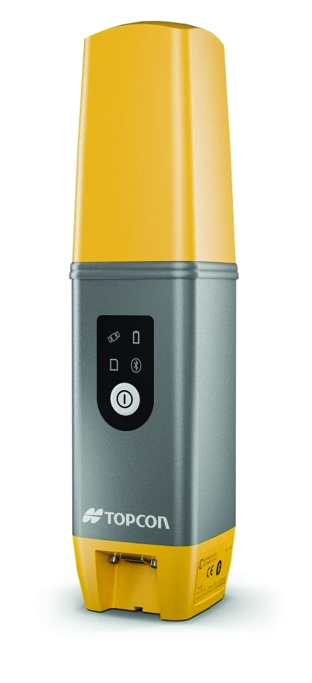
GNSS Receiver Designed for centimeter-level and RTK accuracy
The HiPer CR is a compact and lightweight GNSS receiver designed for centimeter-level and RTK accuracy for professionals in a wide range of applications in surveying, construction, engineering, forestry and mining. It joins a portfolio of fuller-featured receivers, including the HiPer HR and VR.
The HiPer CR tracks the GPS, GLONASS, Galileo, BeiDou and QZSS constellations. It can be used in a variety of configurations, including as a network RTK rover, in base and rover setups and in integrated hybrid use with a robotic total station.
When used as a network rover with Topnet Live — the company’s global GNSS correction service — the HiPer CR will have access to high-quality data corrections to increase efficiency and productivity. Users also can select to use the receiver as part of a hybrid positioning system, which allows users to use a robotic total station for prism measurements. Users also can switch to GNSS measurement with the HiPer CR for obstructed areas such as warehouses, trailers, or buildings.
Topcon Positioning Systems, topconpositioning.com
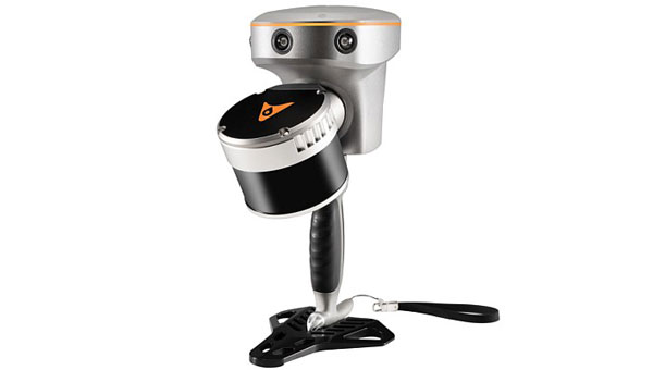
Handheld SLAM laser scanner For in the field and indoors
The RS10 is a handheld SLAM lidar laser scanner integrated with a full real-time kinematics (RTK) GNSS receiver.
Designed to improve efficiency across a wide range of mapping and surveying applications, the RS10 seeks to provide professionals with a versatile, all-in-one tool for capturing 3D geospatial data in both outdoor and indoor environments.
The RS10 integrates a GNSS smart antenna for RTK positioning accuracy even in challenging environments. It delivers 5 cm measurement accuracy by fusing high-precision lidar, RTK, laser and visual SLAM using three HD cameras.
The RS10 uses a powerful onboard processor for real-time georeferenced point cloud generation in the field. Users can receive instant feedback, which allows them to adjust while scanning. Large sites up to 13,000 square meters can be mapped in real time.
The integration of high-precision GNSS and SLAM technologies eliminates the need for traditional loop closure, which often complicates the data collection process for handheld scanners. Users can freely scan target areas without having to return to previous locations, which can streamline field data capture and significantly reduce time spent in the field. CHC Navigation, chcnav.com
Airborne lidar sensor With scan pattern reconfigurability
The Leica TerrainMapper-3 airborne lidar sensor features a new scan pattern reconfigurability to support a variety of applications and requirements in a single system.
The system offers three scan patterns, which allow users to customize the sensor’s performance to fit specific applications. Its circle scan patterns are designed to improve 3D modeling of urban areas or steep terrains. The ellipse scan patterns use data capture for more traditional mapping applications. Skew ellipse scan patterns are aimed at improving point density for infrastructures and corridor mapping applications.
The sensor has a high scan speed rate and a 60° adjustable field of view to maximize data collection with fewer flight lines. The TerrainMapper-3 is complemented by the Leica MFC150 4-band camera, which operates with the same 60° field of view coverage as the lidar for exact data consistency.
The device’s reduced beam divergence offers more accurate results, while its new multiple pulses in air (MPiA) handling is designed to deliver more consistent data acquisition, even in steep terrain.
The system introduces possibilities for real-time full waveform recording at a maximum pulse rate to open opportunities for advanced and automated point classification. Leica Geosystems, leica-geosystems.com
Mobile Mapping Solution Mounted on vehicles or trains
The Trimble MX90 mobile mapping system integrates advanced Trimble GNSS and inertial technology with Trimble field and office software. It offers users a comprehensive field-to-finish mobile mapping solution designed for robust workflows for data capture, processing and analysis.
The MX90, mounted on vehicles or trains, captures detailed laser scans and imagery —panoramic and multi-angle. This data, collected at highway speeds, undergoes rapid processing to produce deliverables for feature detection and inspections.
The mobile mapping system includes immersive 360° panoramic and targeted cameras to capture high-resolution imagery of various details, such as small or distant road and rail signs, telecommunications towers or cracks and holes in roads.
Additionally, it offers high-density colorized point clouds with rich and accurate color projections. These dense point clouds, along with high-resolution imagery — panoramic and planar — and accurate trajectories, provide the basis for a wide range of deliverables, including street scenes, road and rail asset details, elevation models, volume calculations, 3D city models and as-built surveys.
It features a high-end inertial measurement unit (IMU) combined with IN-Fusion+ data processing technology to achieve high-quality data in challenging GNSS environments. The MX90 also comes with reliable office software solutions to support multiple use cases and applications, such as road inspection workflows and integration into cloud-based applications for efficient data sharing. Trimble Geospatial, geospatial.trimble.com
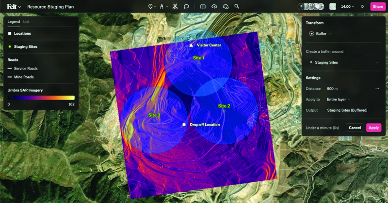
Collaborative Mapping Tool With spatial analysis features
Felt 2.0 is a collaborative mapping tool with powerful data transformation tools. Now with spatial analysis features, users can manipulate and analyze geographic data. It has web-based collaboration features designed to make mapping workflows interactive and accessible across organizations.
The software uses artificial intelligence (AI) to deliver faster workflows for geographic information systems (GIS) professionals. Users can utilize Felt’s Upload Anything capabilities to visualize any file format. The system will read, understand and deliver an internet-fast visualization to the users’ workspace. The software is available for download on tablets and other mobile devices. Felt, felt.com
Automatic Identification System Available on Android, IOS, PC and Mac
The Over the Horizon (OHA) automatic identification system (AIS) is the newest update to the savvy navvy app. The update uses a phone’s internet connection to stream other vessels’ locations in real-time directly to the app to improve safety on the water.
Traditional AIS received from the transceiver on the boat has a range of a few miles, whereas OHA is designed to show vessels further afield. While OHA does require an internet connection, users do not need additional hardware to see information on vessel movements.
OHA AIS allows users to see vessels directly on the chart with small and large vessel crafts defined by different colors. Users can also check how crowded an anchorage might be — either from onboard or while planning routes at home.
The savvy navvy application highlights when no position has been received for more than 30 seconds, which marks the positional variance area around each vessel and allows users to be extra vigilant when navigating.
Available on Android, IOS, PC and Mac, the savvy navvy app can be used on multiple devices and is available in both free and “premium” options with enhanced access and functionalities. savvy navvy, savvy-navvy.com
UAV
Real-Time Command and Control System Supports BVLOS
VigilantHalo is a software-based platform designed for real-time command and control of uncrewed airspace. The system supports a wide range of missions from air traffic control (ATC) to beyond visual line-of-sight (BVLOS) operations and counter-uncrewed aerial systems (C-UAS).
VigilantHalo combines radar and multi-sensor surveillance technology into a comprehensive situational awareness solution. It is designed for disaster response and critical infrastructure defense and can be customized for specific mission requirements. The system’s flexibility allows deployment across cloud, mobile or fixed-site installations, which aims to address the evolving threats in national security and the National Airspace System (NAS).
The system features integrated data processing, a fusion tracker and a communications system that enables operators to monitor and manage air traffic under various conditions. It leverages weather analytics from the National Oceanic and Atmospheric Administration (NOAA) and other sources to assess flight paths and identify safety risks. VigilantHalo uses a custom sensor data processor (SDP) that integrates data from different sensors and surveillance feeds into a unified display tailored to specific missions such as ATC, BVLOS, air defense and more.
BlueHalo, bluehalo.com
Dynamic Channel Switching Improves communication in the field
The Skydio X10D UAV features dynamic channel switching to monitor signal interference and move to a clearer channel. This aims to improve wireless transmission signal quality during flights to ensure troops maintain communication with the UAV to accomplish their mission.
Dynamic channel switching allows the X10D to provide adaptable communications between the drone and its accompanying controller in situations where the airspace is congested or under electronic warfare conditions. This feature ensures that reliable command and control is maintained and real-time data feeds are available even in challenging conditions.
The X10D is designed for intelligence, surveillance and reconnaissance (ISR) applications critical to defense and government agencies. It delivers advanced sensor technology, autonomous navigation and a modular, open architecture for military needs.
Skydio’s onboard AI and autonomy for small unmanned aircraft systems (sUAS) offers obstacle avoidance in zero-light environments and autonomous flight. Skydio X10D delivers enhanced compliance with federal standards, including the Robotics and Autonomous Systems – Air (RAS-A) Interoperability Profile (IoP) and an open, modular platform that supports third-party applications. RAS-A compliance and open MAVLINK protocol enable the use of third-party and government-owned flight application software. Skydio, skydio.com
Lidar Sensor Integrates with UAVs
The JoLiDAR-1000 is a new lidar sensor for UAVs. It aims to improve applications in GIS, surveying, and precision inspections of power lines. The JoLiDAR-1000 incorporates advanced lidar technology to improve measurement accuracy for UAV applications.
The sensor features a 1,000 m medium-range laser scanner, using RTK and inertial measurement unit (IMU) fusion technology and laser scanning for enhanced measurement precision. It achieves a measurement accuracy of 5 mm, a repetition accuracy of 10 mm and a line scanning speed ranging from 10 lines to 300 lines per second. It has a 100° field of view and an angular resolution of 0.001 to precisely detect objects at extended distances.
Designed with compact dimensions and weighing only 1.9 kg, the JoLiDAR-1000 is portable and integrates seamlessly with various UAV platforms. It incorporates a suite of technologies, including a GNSS high-precision positioning system, IMU, high-speed data acquisition systems, time synchronization systems and a 26MP RGB camera to enhance its data collection capabilities.
The JoLiDAR-1000 streamlines operational processes by eliminating the need for base station setup and ground control points. It is equipped with high-precision POS solution computation and point cloud fusion capabilities. The sensor is suitable for a wide range of applications such as terrain mapping, power line inspection, mining surveying, coastline measurement, emergency mapping and natural resource surveying.
JOUAV, jouav.com
AI Autopilot Designed for USVs
The Voyager AI Autopilot converts newly built or retrofitted unmanned surface vessels (USVs) into fully autonomous craft.
The Robosys Autopilot module seamlessly integrates with Robosys’ Voyager AI Survey as part of the Voyager AI software suite. It enables remote and autonomous heading and speed control as well as various other mission modes for navigation and vessel control, specifically for hydrographic and oceanic surveying operations.
The marine autopilot is designed to meet the demands of 3 m to 12 m electric drive surveys. It is easily scalable to full advanced autonomous navigation, which seamlessly integrates with third-party steering, drive and motor control systems to provide optimal vessel functionality for USVs and other craft.
Robosys Automation, robosysautomation.com
OEM
Satellite Positioning Chips With AEC-Q100 Grade 2 reliability qualification
Designed for automotive applications, the AG3335MA satellite positioning chip series has earned AEC-Q100 Grade 2 reliability qualification. The AEC-Q100 is designed to ensure reliability and safety beyond the requirements for consumer electronics.
The AG3335MA series chips have been certified by a third-party quality management system equipped with an automotive specification laboratory. Achieving Grade 2 certification, these chips are tested for operation in extreme temperatures ranging from -40°C to 105°C, which caters to the demanding environments of automotive applications.
The AG3335MA features ultra-low power consumption, high endurance and dual-frequency capability. It supports the five major global satellite systems and NavIC to ensure reliable operation in a broad temperature range and challenging weather conditions. Its GNSS receiver measurement engine has a satellite tracking sensitivity of -167 dBm and a cold boot positioning time of 25 seconds. This allows it to receive and process signals from all visible satellites simultaneously, offering increased accuracy in positioning.
Airoha Technology, airoha.com
SOM-SMARC Modules Powered by Qualcomm
The Smart Mobility Architecture (SMARC) System on Modules (SoMs) are based on Qualcomm QCS6490 and Qualcomm QCS5430 application processors. These new SMARC modules are the first results of SECO’s strategic collaboration with Qualcomm Technologies, announced in September 2023.
The SOM-SMARC-QCS6490 is designed to simplify the use of the Qualcomm QCS6490 processor. The chipset offers support for artificial intelligence (AI) and computing, robust performance at low power and expanded interfaces and peripherals catering to diverse industrial use cases.
The Qualcomm Adreno 643 GPU offers enhanced graphics performance and energy efficiency. It supports FHD+ at 120 fps resolution on primary and secondary displays up to 4k Ultra HD at 60 Hz. The SOM-SMARC-QCS6490 supports Microsoft Windows 11 IoT Enterprise, Yocto Linux and Android, with both commercial (0°C to +60°C) and industrial (-30°C to +85°C) temperature variants available.
The SOM-SMARC-QCS5430, powered by the Qualcomm QCS5430, is a mid-tier solution that slightly moderates CPU and GPU performance. This system-on-chip (SoC) combines enhanced connectivity, performance and edge AI-powered camera capabilities. It also provides scope for field software-based upgrades of the CPU and GPU by using the processor’s capabilities.
SECO, seco.com
INS Featuring FOG-based IMU
The Phins 9 Compact is a high-performance inertial navigation system (INS) designed for all unmanned underwater vehicles. It offers a blend of navigation performance, reliability and size, weight and power (SWAP) efficiency.
The Phins 9 Compact is built around a high-performance fiber-optic gyroscope (FOG)-based IMU with advanced accelerometers. With compact dimensions, a DVL-aided position accuracy of 0.1% TD, and a power consumption of less than 7 W, it is ideal for compact subsea vehicles in demanding applications with low power requirements.
The INS aims to redefine the standards of subsea navigation in a wide range of applications, including survey-grade coastal and offshore seabed mapping, inspection repair and maintenance (IRM), defense and more. Exail, exail.com
MOBILE
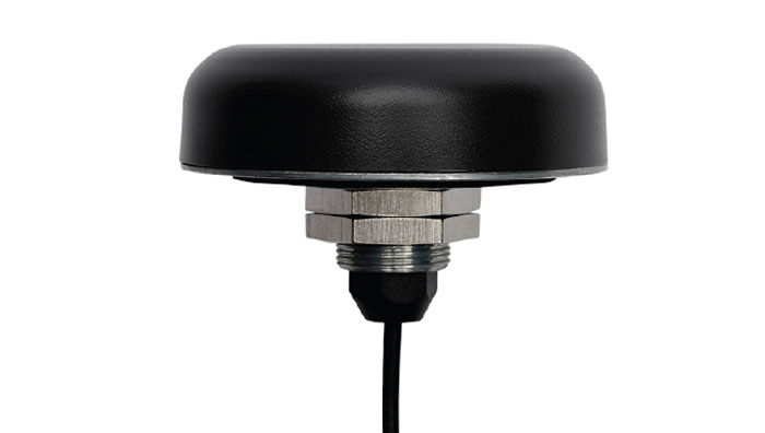
GNSS FR Antennas Supports a full spectrum of bands
This series of GNSS RF antennas is designed to elevate location-based services with enhanced accuracy and precision. This new lineup aims to outperform conventional GPS technologies by offering faster signal acquisition, improved tracking capabilities and reduced power consumption.
The antennas support a full spectrum of bands, including L1, L2, L5, and L-band data correction services. It can be used in a variety of sectors, such as agriculture, surveying, the Internet of Things (IoT), mapping, defense and aviation.
The technology is designed to meet the rigorous demands for precise location data across various applications. These antennas offer multi-band and multi-constellation support to ensure broad compatibility. With centimeter-level accuracy, these antennas are crucial for aerospace, defense, asset tracking, geolocation, precision agriculture and industrial IoT. Abracon, abracon.com
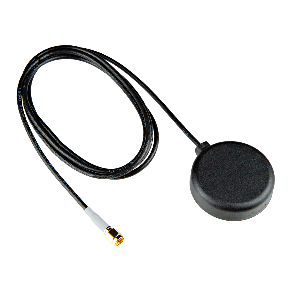
Iridium on the Go Magnetic mount antenna
The 2J7426MPz by 2J antenna is a high-performance magnetic mount antenna that is designed specifically to communicate efficiently with the Iridium satellite communication system. It is manufactured with high-quality polycarbonate (PC) and acrylic-styrene-acrylate terpolymer (ASA), a thermoplastic combination that offers strong resistance to UV, moisture, and heat and enhances mechanical properties.
The antenna housing is waterproof to IP69 standards and designed to operate in extremely harsh environments, including those with frequent exposure to water, dust and debris. It has a recommended operational and storage temperature of -40°C to +85°C. The magnetic mount allows for easy installation and removal between vehicles or assets, and it is easily converted to an adhesive type for greater flexibility.
It is delivered with a standard SMA-male connector and a standard 300 cm long coaxial LL100 cable. Iridium has certified the 2J7426MPz antenna for commercial use in connection with the Iridium communications system. SparkFun Electronics,sparkfun.com
Calian GNSS, formerly Tallysman Wireless, has released its TW5387 industrial-grade smart GNSS antenna. It integrates the Quectel ST TESEO V GNSS receiver chipset onto the Calian compact smart GNSS antenna platform to offer dual-band GNSS, eXtended filtering, low phase center variation, low signal-to-noise ratio and dual feed and patch for strong multi-path rejection.
The TW5387 comes with RTK rover capability and a built-in IMU for sensor fusion. It is designed to minimize RF impairments that affect the performance of the GNSS receiver and provide GNSS coordinates to the host system over a robust digital interface for noise resilience.
TW5387 is suited for automotive, UAV, robotics and defense applications that require precise location and timing. TW5387 is compatible with N-RTK correction services such as Point One Navigation’s Polaris and Swift Navigation’s Skylark.
It tracks GPS, Galileo, BeiDou and L1/L5 band operation and is housed in an industrial-grade IP69K enclosure.
Quectel Wireless Solutions has expanded its antenna portfolio with the introduction of 5G antennas and high-performing GNSS antennas, designed to improve positioning and navigation capabilities for Internet-of-Things (IoT) devices.
The YEGB000Q1A and YEGN000Q1A active GNSS L1 and L5 antennas are designed to precisely tap into L1 and L5 frequency bands, which is crucial for advanced navigation applications. These antennas, operating within the 1164-1189MHz and 1559-1606MHz frequency bands, are designed to support a variety of installation methods, catering to diverse application needs with options for screw mount, adhesive mount, magnetic mount and various cable connections.
Quectel’s GNSS antennas are part of a broader release that includes the YEMN016AA and YEMN017AA 5G 5-in-1 combination antennas, which also feature GNSS capabilities.
These GNSS antennas are crucial for applications that require high levels of navigation accuracy, such as autonomous vehicles, UAV delivery systems and precision farming.
In addition to the GNSS-focused antennas, Quectel introduced external 5G antennas, the YECN001J1A and YECT000WBA, designed for omnidirectional high-speed data transmission. They are compatible across 5G NR Sub-6 GHz, 4G, 3G, 2G and LPWA bands, offering flexibility and high efficiency for wireless communication devices.
Quectel provides extensive support for its antennas, including custom antenna solutions tailored to users’ specific needs. This support includes design, simulation, testing and manufacturing services to offer optimal integration with Quectel’s wide range of modules for IoT deployments.
Geneq has introduced SXblue GLOBE for GNSS positioning and GIS technology. The system is designed to deliver positioning accuracy, efficiency and reliability in challenging field conditions using a 448-channel GNSS board.
It has advanced technologies for multipath mitigation, which aims to reduce the effects of signal reflection and ensure the integrity of positioning service, even in GNSS-challenged environments. The SXblue GLOBE incorporates an anti-jamming and interference monitoring system, safeguarding against disruptions and ensuring uninterrupted operation in any scenario, the company says.
The system uses global or local coverage of correction services satellite-based augmentation system (SBAS), real-time kinematics (RTK) with an update rate of up to 100Hz. This seeks to provide users with enhanced accuracy and reliability in positioning activities. Sxblue GLOBE features Wi-Fi connection, which allows its parameters to be easily configured via a web user interface.
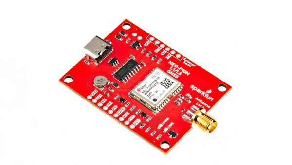
SparkFun Electronics has released the NEO-F10N GNSS L1/L5 Breakout board. This GNSS breakout board features the u-blox NEO-F10N module and a dual-band L1/L5 configuration designed to add precision to GNSS projects operating in urban and rural environments. Additionally, the L5 signal falls within a protected frequency band, which reduces RF interference on the incoming signal.
This breakout supports the concurrent reception of three GNSS constellations: GPS, Galileo, and BeiDou. The proprietary dual-band multipath mitigation technology from the u-blox F10 allows the module to choose the best signals from both bands to achieve a significantly better position accuracy in challenging urban environments than with the L1 band alone.
It has an integrated rechargeable battery that powers the RTC on the NEO-F10N, which reduces the time-to-first fix from cold to hot starts. The battery also maintains RTC and GNSS orbit data without external power to offer uninterrupted performance.
u-blox-based GPS products are configurable using u-center. This offers users extensive customization options such as baud rates, update rates, spoofing detection and more.
Swift Navigation has partnered with Telit Cinterion to enhance the precision of GNSS positioning in low-power consumption devices such as wearables, robotic lawnmowers and vehicle tracking systems.
Under the collaboration, Telit Cinterion’s GNSS receivers will use Swift’s Skylark precise positioning service, which is designed to deliver consistent precision across vast areas while prioritizing energy efficiency, reducing processing demands and minimizing data transmission costs. It aims to provide accurate location information quickly, even in difficult environments such as urban centers and canyons where signals can be obstructed.
This partnership seeks to enhance location-based applications by allowing these devices to achieve centimeter-level accuracy. This level of accuracy is crucial for the safe operation of autonomous vehicles and industrial robots, but integrating it into small, battery-powered devices has been a complex challenge until now.
The solution is designed to comply with industry standards, making it interoperable with various GNSS chipsets, modules, receivers and applications.
SparkFun Electronics has released the 2J7426MPz by 2J antenna, a high-performance magnetic mount antenna designed to communicate with the Iridium satellite communication system. It is manufactured with high-quality polycarbonate (PC) and acrylic-styrene-acrylate terpolymer (ASA), a thermoplastic combination that offers strong resistance to UV, moisture, and heat and enhances mechanical properties.
The antenna housing is waterproof to IP69 standards and designed to operate in extremely harsh environments, including those with frequent exposure to water, dust and debris. It has a recommended operational and storage temperature of -40°C to +85°C. The magnetic mount allows for easy installation and removal between vehicles or assets, and it is easily converted to an adhesive type for greater flexibility.
It is delivered with a standard SMA-male connector and a standard 300 cm long coaxial LL100 cable. Iridium has certified the 2J7426MPz antenna for commercial use in connection with the Iridium communications system.
The Federal Communications Commission (FCC) is investigating whether the use of Russian and Chinese foreign satellite systems by U.S. mobile phones and other devices poses security threats.
The FCC has concerns that U.S. handheld devices are receiving and processing GNSS signals from satellites controlled by foreign adversaries in violation of commission rules.
The FCC is seeking answers from handset manufacturers Apple, Google, Motorola, Nokia, Samsung and others that collectively cover more than 90% of the U.S. smartphone marketplace.
“There is no established record of what security threats, if any, these signals carry and whether the manufacturers of handheld devices are processing these signals in violation of the Commission’s rules,” an FCC spokesperson said in a statement.
Representative Mike Gallagher, chair of the U.S. House Select Committee on the Strategic Competition Between the United States and the Chinese Communist Party, wrote FCC Chair Jessica Rosenworcel earlier this week raising concern about reports that U.S. cell phones were receiving and processing signals from Chinese and Russian satellites.
The FCC has only approved U.S. phones to receive and process signals from the U.S. Global Positioning System (GPS) and the European Galileo GNSS.