Category: Opinions

  • GPS could have high accuracy and counter spoofing, if…

    GPS could have high accuracy and counter spoofing, if…

    It was 2018. Representatives from the European Space Agency were visiting Google headquarters in Mountainview, California.

    Under discussion was Europe’s plans to introduce a high accuracy and authentication service to their Galileo satellite navigation system. Galileo would broadcast precise point positioning corrections on the E6-B band and provide users decimeter-level accuracy. They would also be including a navigation authentication message enabling receivers to distinguish genuine messages from deceptive ones sent by spoofers.

    Wouldn’t Google like to incorporate these capabilities in future versions of Android phones?

    The answer from Google Distinguished Engineer, Frank van Diggelen, was a resounding “yes.”


    Technologically Possible

    Van Diggelen also had another thought. It should be possible to deliver precise positioning corrections and authentication data via the internet. This could allow phones with an internet connection to access the services as well. With an app, older smartphones would be able to take advantage of the services, and it wouldn’t be necessary to add new hardware to new phone designs.

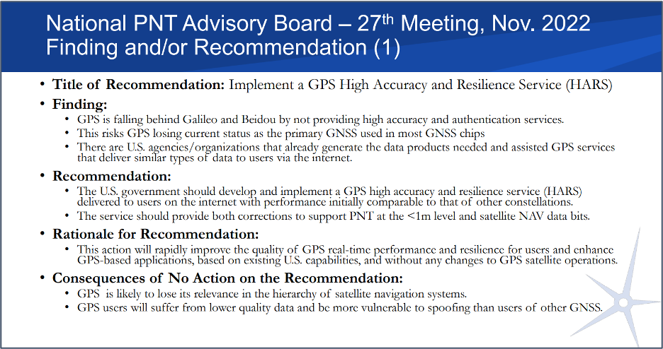
    The next logical step was to establish an internet-based high accuracy and authentication service for the United States’ GPS. Unlike the newer European Galileo and Chinese Beidou systems, GPS satellites don’t have the ability to transmit data to improve accuracy and authenticate signals.

    Technologically, providing corrections for high accuracy and authentication data to users via the internet is entirely possible, according to van Diggelen and other experts serving on the president’s Space-based Positioning, Navigation, and Timing (PNT) Advisory Board (PNTAB).

    Yet a couple of process challenges in the United States could make establishing such a service difficult and might prevent its creation entirely.


    Data collection and use not yet an official program

    The first is related to the way in which the U.S. collects and handles real-time tracking data of the Global Navigation Satellite Systems (GNSS) ­­— GPS, GLONASS, Galileo, and BeiDou ­­— to derive corrections needed for a high accuracy service.

    NASA’s Jet Propulsion Laboratory (JPL) operates NASA’s Global GNSS Network (GGN) of more than 60 stations around the globe, which provide their tracking data to JPL’s Global Differential GPS (GDGPS) System. The GDGPS System also has access to real-time tracking data from hundreds of additional sites, all of which track GPS and other GNSS. This allows the GDGPS System to generate precise corrections for the navigation messages of GPS and other GNSS. It also enables real time decimeter-level accuracy for positioning applications anywhere in the world. These corrections are provided to some government agencies and commercial entities on a reimbursable basis.

    NASA’s GDGPS capabilities are not part of a formal, official government program, though. Rather they have grown organically as part of JPL’s efforts to push boundaries in scientific and engineering applications of GNSS, and its ability to take on work paid for by other agencies. Thus, GDGPS efforts lack a sufficient and established government funding line, formal programmatic tasking, and other structures and procedures needed to ensure its long-term viability as a government-provided service.

    NASA and JPL officials recognized this and in 2020 established a working group to advise on how they should go forward. The following year that working group made several recommendations to NASA and the PNTAB. Among them were to establish a consistent level of NASA funding, create a Level-1 capabilities document for GDGPS, and start discussions towards an interagency memorandum of understanding (MOU) for long-term government funding.

    At the same time, a PNTAB task force investigated the GDGPS activity and made recommendations to the PNTAB. They included: that NASA/JPL document GDGPS capabilities, including architecture, facilities, functions and products; that a stable government funding line for GDGPS be established; that a security review of GDGPS be undertaken; and to maintain GDGPS entrepreneurial aspects in pursuing multi-agency usage of its services.


    Civil GPS rarely needs addressed

    The second challenge to establishing high accuracy and authentication service for GPS appears to be the lack of an identified agent or mechanism within the federal government to do so.

    Europe’s Galileo is a civilian system established and operated to support economic activity and development. The U.S’s GPS is run by the military.

    First created to “put five bombs in the same hole,” it was built and run for years by the U.S. Air Force and is now the responsibility of the U.S. Space Force. Its primary mission is support of military missions and almost all funding comes through the Department of Defense (DOD).

    Yet, indisputably, 99% of GPS users are not in the military and the system has become essential to most technologies and nearly every facet of the U.S. economy.

    Official government policy has long recognized this, at least at the strategic level. Presidential policies issued in 2004 and in 2021 provided for improvements in functionality for civil users – as long as they were required by and entirely funded by a civil agency.

    At a more tactical level, though, attempts to fund civil requirements have always faced great difficulty and rarely succeeded.* Mandates in presidential directives for civil signal monitoring, interference detection and mitigation, increased resilience, alternative PNT, and responsible use have all faced uphill battles and received little funding.

    According to former senior government officials, this difficulty stems from civil GPS use being caught in a bureaucratic “Catch-22.”

    On the one hand, executive branch policy dictates that funding for GPS capabilities and applications benefiting civil users must flow through the Department of Transportation (DOT). On the other, within government programming and budgeting circles, GPS is seen as an expensive military capability funded through the DOD. Requests for GPS and PNT-related funding through DOT are more difficult to explain and are easier to deny.

    Compounding this difficulty is the lack of a clear and empowered national leader to advocate for a comprehensive and national approach to GPS and PNT issues and overcome bureaucratic snags.

    As a result, the path forward for adopting the recommendation for a GPS high accuracy and resilience service is, at best, unclear.

    Yet many on the President’s advisory board and in government are hopeful. “Establishing a high accuracy and resilience service for GPS is the right thing to do” said one. “We have all the pieces to make this happen. We just need to bring them together.”

    And as one of the board members commented at the recent meeting, if the U.S. doesn’t do this “It stinks.”

    Photo:
    Image: Slide from the National PNT Advisory Board Meeting in November 2022

    *The exception to difficulties funding civil GPS-related capabilities is the Federal Aviation Administration’s Wide Area Augmentation System. It was established as the result of heavy lobbying by the airline industry, which continues to give it strong support.

  • Editorial Advisory Board: The “geodesy crisis” and GNSS satellites

    Editorial Advisory Board: The “geodesy crisis” and GNSS satellites

    What are your thoughts on the “geodesy crisis” and what do you propose to address it?

    Bernard Gruber
    Bernard Gruber

    “Evidence seems to be very clear that we, as a country, need geodesists and that there has been a decline in investments, training, and research in geodesy. While our decline relative to China may be shocking, it should not be surprising. U.S. industry and government relentlessly pursues STEM graduates, or those with relevant experience, but that does not meet current needs. Besides maybe surveying, it is unclear to the public what the geodesy profession is all about, why it is needed, and quite frankly, why it is an exciting career choice.”

    — Bernard Gruber
    Northrop Grumman


    Does crowding of low-Earth-orbit (LEO) space — with new satellites and space debris — pose any problems for the launch or operations of GNSS satellites in medium
    Earth orbit (MEO)?

    Ellen Hall
    Ellen Hall

    “This was a focused topic at SATELLITE 2022, where the discussion centered on the 6,000 tons of space debris circulating in LEO. Even the smallest piece of debris can be lethal to a satellite, so the key is to track and maneuver where possible. Add to that about 5,000 active satellites and plans to launch tens of thousands of additional ones into LEO over the next few years, and you have a serious problem to overcome. While there are treaties and plans for tracking and maneuvering these satellites, the debris is the real challenge.”

    — Ellen Hall 
    Spirent Federal Systems


  • GPS Technologies Enable an Accessible World

    GPS Technologies Enable an Accessible World

    Photo: WeWALK
    The WeWALK cane attachment and app was produced with partnerships with Microsoft and Imperial College London. (Image: WeWALK)

    While some may only think of GPS technology as a convenience when driving a car or hiking, for many, GPS is a necessity. Through navigation devices, adaptable software, and mobility aids, GPS technology has become a vital part of accessibility efforts to support people with hearing loss, deafness, or visual impairments.

    The World Health Organization estimates that at least 2.2 billion people are living with a vision impairment, and 430 million people are living with a disabling level of hearing loss. For these billions of people, everyday tasks such as navigating a new city or using public transportation can be a challenge. GPS technology gives people the independence needed to meet these challenges with confidence.

    Damato
    Damato

    GPS technology in handheld navigation devices and adaptable software promotes accessibility and assists individuals with daily tasks. Accessibility features that rely on GPS technology can give users turn-by-turn directions to any destination, detailing the terrain, surroundings, and even relevant bus or metro stops along the way. Vibration signals complement voice directions to help users navigate busy areas and intersections regardless of visual or hearing abilities. These accessibility features make new spaces more accessible to people with vision and hearing loss by leveraging the ease and accuracy of GPS navigation technology.

    Through innovative technologies and accessibility features, GPS also enables users to explore their surroundings. The “around me” feature on many GPS applications will read aloud descriptions of, and distances to, businesses, street names, and transportation options in the surrounding area. These resources allow individuals with hearing or vision loss to explore their communities and complete daily tasks worry-free. Interactive applications let users move their fingers along a screen while the device reads out street names and provides directions, helping users find their way in unknown locations. This ensures users have all the information they need to be confident exploring new places on their own.

    In addition to helping individuals with vision and hearing loss navigate their surroundings, GPS technology also promotes safety and ensures individuals can be quickly located in the event of an emergency. For example, location tracking apps allow users to share their exact location with family and caretakers, promoting individual autonomy while also ensuring safety. If an emergency does occur, GPS technology helps emergency services quickly and accurately locate individuals and provide care.

    From navigational accuracy to safety monitoring, the GPS Innovation Alliance (GPSIA) is proud to support the role of GPS technology in creating a safe, more accessible world for individuals with hearing or vision loss. Innovations in GPS technology, such as real-time location information and direction signaling, are changing the field of accessible technologies. GPSIA will continue to advocate for policies that promote and support the application of GPS in this field, encouraging all individuals to confidently lead an independent life.

  • First Fix: Arrivals and Departures

    First Fix: Arrivals and Departures

    Matteo Luccio
    Matteo Luccio

    As we begin 2023, GNSS development continues apace, as described in this issue’s annual “Directions” section by representatives of Galileo, GLONASS, and BeiDou. We plan to publish a similar update on the GPS program soon.

    Galileo’s user base now stands at more than 3.5 billion, and the services it provides continue to improve and expand. Beginning early this year, free precise point positioning (PPP) corrections for Galileo and GPS (single- and multi-frequency) will improve real-time user position by up to 10 times. While the discontinuation of Soyuz launch services from the Kourou Space Centre in French Guiana, due to the Russia-Ukraine conflict, delayed the two Galileo launches that had been planned for last year, 2022 was a key year for the development of Galileo Second Generation (G2G) satellites. They will provide, among other innovations, a reconfigurable fully digital navigation payload, point-to-point connection between satellites, and advanced jamming and spoofing protection mechanisms.

    On Nov. 29, 2022, Russia launched the 51st Glonass-M satellite, about 20 years after launching the first one. Currently, 13 of these satellites are operating beyond their guaranteed lifetime, with an average orbit lifetime of more than 10 years. Starting this year, the constellation will be renewed by Glonass-K and Glonass-K2 satellites, which provide CDMA signals to users.

    Currently, 45 BDS satellites are operational in orbits, including 15 BDS-2 satellites and 30 BDS-3 satellites. The constellation says that it has reached a continuity of 99.996% and an availability of 99%, with a global positioning accuracy better than 1.5 meters horizontally and 2.5 meters vertically (95% confidence).

    Tracy Cozzens, who has been a pillar of this magazine for 17 years, is retiring this month. We will miss her journalistic acumen, dedication to clarity and style, attention to detail, and wealth of institutional knowledge. We wish her a well-deserved retirement. At the same time, we welcome aboard Maddie Saines, our new managing editor, who is near the beginning of her career.

    I am pleased to announce that Rob VanBrunt has joined GPS World’s Editorial Advisory Board. In mid-December, the board of directors of Spirent Federal Systems, a provider of PNT test solutions for the U.S. government and contractors, appointed him as the company’s president/CEO-designate, a role he will assume when the onboarding process is complete.

    VanBrunt began his career at Spirent Communications in 1990 as product developer and manager, and then held posts of increasing responsibilities, moving to director and vice president roles focused on management, strategy and mergers and acquisitions. Most recently, he was executive vice president in the Office of Business Excellence. VanBrunt has a B.S. in electrical and electronics engineering from Rutgers University.

    Spirent Communications is a global provider of automated test and assurance solutions for networks, cybersecurity and positioning. In July 2001, the company formed Spirent Federal Systems as a wholly owned subsidiary and U.S. proxy company. Spirent Federal markets and sells Spirent Communications’ products in North America. It also provides value-added features and ongoing customer support.

    On Jan. 1, I lost my beloved mother, Maristella “Mimi” Luccio. She was 87.

    Matteo Luccio | Editor-in-Chief
    [email protected]

  • Unmanned and autonomous news

    Unmanned and autonomous news

    Browsing through the news from the Consumer Electronics Show (CES) in Las Vegas last week, there seems to have been the regular number and variety of ‘robots’ demonstrating various capabilities from basic movement to almost complete human-like animation and speech. There were also a few more demos related to navigation and autonomy that could be of more interest to our readership. In particular, the case was made for more extensive use of drones for deliveries and in agriculture.

    Apparently, the FAA was at the show – promoting the use of unmanned aerial vehicles (UAV) for ‘last mile’ deliveries. The gist of one presentation was that UAV deliveries could possibly reduce the need for people to drive to a store for a pick-up. If we drive, we periodically have accidents – probably someone has estimated the probability that anyone getting into a vehicle will have an accident and suffer varying degrees of damage to property, life or limb.

    So, if drone and automated ground vehicle deliveries were to be universally accepted and implemented, lives would be saved, people’s lives wouldn’t be as disrupted and costs for hospital care and vehicle repairs would be reduced. All good, right? However, people are still not sold on UAV flying over their neighborhoods because they might fall out of the sky and hurt someone or damage property, make lots of noise and disturb their peace and quiet or use the opportunity to invade their privacy. Therefore, delivery start-ups are still struggling through FAA and local red-tape to get airborne — which at this stage is probably not a bad thing — as we get safety objectives straight, and train people well enough to reduce error rates to below acceptable limits.

    Another example used by the FAA at CES was the health risks for pilots of crop spraying aircraft, which are largely used on medium to large scale farms in the United States. The health hazard of the pesticide spray and aircraft accidents during aircraft crop dusting — rapidly, repeated ‘swoop’ to low over the field, low level overflight to spray, then rapid climb and turn maneuver — could be largely avoided by UAV spraying systems, which have already been implemented in many countries around the world. The problem, however, is that the adoption of UAV spraying has perhaps been slower than anticipated.

    Photo:
    A UAV delivering groceries. Image: Walmart
    Photo:
    Crop dusting. Image: Stefan Krause


    Crop dusting aircraft can apparently treat about 600 acres/day on larger farms, while drones are only able to carry much smaller spray tanks, with a capacity of about 8 gallons, which enables spraying of 30 acres-per-hour. In addition, batteries on UAV need to be exchanged regularly, hopefully at the same time as spray tanks are refilled. While one pilot flies a crop duster aircraft, a UAV operation not only requires a skilled pilot to fly the UAV, but also a line-of-sight observer under FAA regulations. So, labor costs are higher, somewhat offsetting the lower operational costs of a UAV.

     Nevertheless, the limited number of crop dusters requires scheduling out days, several weeks even in the busy seasons. Whereas, if you own an agricultural UAV only the weather determines when you can treat your own crops.

    So why is it taking time for this alternative approach to take off?

    Let’s say you buy your own small UAV — one capable of 1-2 gallons-per-acre for a small farm. You would first need to take an operator’s course and qualify for a pilot’s license, then you would have to work city hall to obtain an aerial applicator’s license and a state pesticide applicator’s license. Then you would have to pass an FAA physical, and maybe obtain an exemption to fly a UAV over the standard 55 lb weight. If you wanted to fly after dark, you would also need a night operator’s license. If you wanted to fly several UAV simultaneously (a swarm) to get the job done quickly, you would need to train and become qualified. These things are a significant barrier to entry for individual farmers. Therefore, companies are springing up that will charge equivalent prices for turn-key UAV crop applications as for aerial crop dusting – say between $11 -14 per acre.

    Photo:
    Autonomous AG-116 crop-spraying drone. Image: Hilio

    UAV do have a place in the business of agriculture for crop spaying, even alongside conventional crop-dusting aircraft, and costs seem to be competitive if a farmer were to buy turn-key spraying. The obstacles to overcome for someone to start a UAV spraying business seem somewhat prohibitive, but companies are taking on the challenge and offering services. Farm owners who want to manage their own regular pesticide and fertilizer applications using their own UAV have a steep learning curve to climb.

  • DHS Report on Denver Jamming – More questions than answers

    DHS Report on Denver Jamming – More questions than answers

    The Cybersecurity and Infrastructure Security Agency (CISA) at the Department of Homeland Security (DHS) recently released a three page “CISA Insights” document titled “Global Positioning System (GPS) Interference.” The January 2022 GPS jamming incident in Denver is discussed on the first page as an example of bad things that can happen and why GPS users should take precautions against interference.

    Issued eleven months after the event, the report provides little new information, and leaves several important questions unanswered.

    Photo:
    Image: YayaErnst//iStock/Getty Images Plus/Getty Images

    Delay in locating and ending interference

    One of the most important questions is why it took so long to locate and end interference from a strong signal impacting such a large area.

    The Federal Aviation Administration (FAA) was the first agency to become aware of the issue and the report credits the Enforcement Bureau of the Federal Communications Commission (FCC) with finding and terminating the spurious transmission.

    Despite an “established national coordination process,” the interference was unabated for 33 hours.

    While the report does not give details of the delay, likely reasons include the large number of agencies involved, diffuse authorities and responsibilities, the lack of a national interference detection system or a GPS/PNT “command center,” and several decades of funding and staffing reductions for FCC’s Enforcement Bureau.

    How and why it happened

    One of the primary reasons for doing an analysis of an accident like this is to prevent similar events in the future. Yet the CISA report provides no helpful information in this regard. It does not identify the source, nor the chain of events leading to the presumably accidental interference.

    Those who might take steps to ensure that their operations don’t accidentally interfere with GPS signals learn nothing from the document.

    A similar GPS jamming event occurred in October 2022 in the Dallas area. That one lasted 44 hours and the source was never identified. One wonders if this could have been prevented if the CISA report had been issued earlier and included more information.

    Why the general public was not warned

    The FAA issued a Notice to Airmen as soon as it became aware of the problem. The CISA report says surface (road and highway), rail, and telecommunications users were also impacted. Undoubtedly other types of users were also affected. Yet despite the outage lasting almost a day and a half, no public warning was issued to inform and protect non-aviation interests.

    At a minimum, such a warning could have saved companies a lot of trouble and effort. A trouble report during the event from one public safety system operator provides an example of the unnecessary effort expended because a company did not know about the on-going disruption:

    “Approximately 1530 on 21 DEC 22 two of our base transceiver systems began to lose sync. The GPS receivers, control cabling, and surge protectors were replaced with no change to loss of sync. There are no other BTS affected other than three sites in Aurora, Colorado … also problems with the local public safety P25 simulcast systems which have lost GPS lock in this area. Spok provides critical encrypted health care communications at these facilities.”

    Warning the public could also help prevent more serious consequences, like the loss of life and property.

    Troubling assertion

    In this case, no losses of life or property have been connected to the disruption.

    Yet the CISA report makes a more affirmative statement that “No accidents or injuries occurred because of the GPS interference incident.”

    While we all certainly hope that was the case, and it may well be true, the CISA statement is troublingly certain.

    A fairer and more accurate statement would be that “…none occurred, that we know of…” This would acknowledge that GPS is a safety of life system in many applications, and the seriousness of interference events.

    Striving to do better

    After its discussion of the Denver incident the report says improving GPS interference detection and mitigation is a CISA priority. And they are leading an interagency review to improve things.

    This will be an uphill battle.

    One challenge is DHS and other departments and agencies have limited authorities. The FCC is legally responsible for ensuring transmitters don’t trespass into unauthorized frequencies. However, its resources are limited and, as an independent agency not part of the administration, its participation in cross-governmental efforts is entirely voluntary.

    Another is the lack of a clear, authoritative leader and champion for positioning, navigation, and timing (PNT) issues within the federal government.

    Executive branch policy scatters PNT-related tasks thinly across the administration. These are to be coordinated by a senior level executive committee tasked to make recommendations “…to the President, through the Assistant to the President for National Security Affairs, or the Executive Secretary of the National Space Council…”

    It is not hard to imagine that the details of PNT policy are rarely, if ever, brought to the attention of the President. This can lead to a stalemate between much more junior White House officials and greatly inhibit action.

    Let’s hope the CISA report, limited as it is, highlights for leadership the many challenges faced by folks across government who care about GPS reception and national PNT issues. And that, as they collaborate on good solutions, they get the policy and budget support they deserve.

  • Updates on NGS’s published heights in southeast Texas and NGS GPS on Benchmarks program

    Updates on NGS’s published heights in southeast Texas and NGS GPS on Benchmarks program

    First, happy New Year to everyone. As a follow up to my November 2022 column on the geodesy crisis, I’d like to highlight that the National Geospatial Advisory Committee (NGAC) of the Federal Geographic Data Committee (FGDC) just adopted a resolution on the need for the federal government to understand and aggressively address the US geodesy crisis. See below.  This is great news and, hopefully, the FGDC and others will follow up with discussions with other organizations such as the Office of Science and Technology Policy (OSTP) in the White House.

    Photo:
    Image: FGDC 

    Now for this month’s column. Last year the National Geodetic Survey (NGS) started suppressing height information in Southeast Texas (see my April 2021 and June 2021 columns).  See below for more information. Last year’s columns highlighted the potential effects of subsidence on published heights in the Houston, Texas, region which implied that most of the published heights, which are based on older surveys in the region, are not current or accurate.  At the time of NGS’s announcement, only 28 marks with orthometric heights were published on NGS datasheets in southeast Texas. Click here for more information and see below.

    This column will provide an update on the following: the current set of published orthometric heights in the southeast Texas region based on recent GNSS surveys performed during 2021 and 2022, NGS’s rules for estimating and publishing GNSS-derived orthometric heights using OPUS Projects, and the status of NGS’s GPS on Benchmarks program.

    Photo:
    NGS Announcement to Suppresses Height Information for Southeast Texas. Image: From NGS Website
    Photo:
    NGS Southeast Texas Orthometric Heights. Image: NGS

    This provides the benchmarks that are available to users (see also below).

    Photo:
    Link to Map SE TX Valid Ortho Heights. Image: NGS
    Photo:
    Image: NGS

    I always retrieve the latest published coordinates using NGS’s datasheet website routine. See the graphic below of the published NAVD 88 orthometric heights as of Nov. 20, 2022 (I used NGS’s monthly archive by State retrieval option).  There are currently 147 marks with published orthometric heights within NGS’s definition of the southeast Texas zone of subsidence. From mid-October to early December of 2022, another GNSS project sponsored by the Harris-Galveston Subsidence District (HGSD) was performed in the region.  In this project, 154 marks in the southeast Texas region were observed. The results of this project should be published and disseminated by NGS in the spring of this year.

    Photo:
    Latest Published Heights in Southeast Texas. Image: Dave Zilkoski

    The current version of OPUS projects allows the user to estimate NAVD 88 orthometric heights, providing they adhere to NGS’s recommendations and procedures. A presentation titled “Heights Suppression in Southeast Texas” by Boris Kanazir, NGS, provides guidance on estimating NAVD 88 orthometric heights using OPUS projects.

    See below for the requirements for number of occupations, duration of each session, and the spacing of marks with valid NAVD 88 published orthometric heights.

    The requirements include:

    • a minimum of two NAVD 88 control marks per new mark observed
    • a mark must be observed twice on different days and at different times of the day
    • the maximum distance between new marks and NAVD 88 control is between 30-50 km, based on session duration
      • 30 km for occupation sessions at least 2 hours
      • 40 km for occupation sessions at least 4 hours
      • 50 km for occupation sessions at least 6 hours
    Photo:
    Slide 42 of NGS Heights Suppression in Southeast Texas Presentation. Image: NGS

    The diagram below depicts how many marks with published NAVD 88 heights are required using a 30 km radius spacing.

    Photo:
    Slide 45 of NGS Heights Suppression in Southeast Texas Presentation. Image: NGS

    I like to think of this concept as drawing Venn diagrams around marks. See below for an example of the concept.

    Photo:
    Venn Diagram. Image: Dave Zilkoski

    So, what does this mean in the real world? The map below demonstrates the concept in the Houston-Galveston, Texas, region.  As shown, many of the 30 km circles overlap, indicating that in these overlapping areas there are two CORS with published NAVD 88 orthometric height.  This means that a user can occupy a mark for two hours and use the data from two CORS as NAVD 88 control.  Of course, the mark must be occupied twice for redundancy.

    Photo:
    30 km Radius Circles around SE TX CORS with NAVD 88 Heights. Image: Dave Zilkoski

    Increasing the radius to 40 km includes more overlapping areas.  This means that the user would have more overlapping areas with two CORS that have published NAVD 88 orthometric heights, but the marks would have to be occupied twice for at least four hours each time.

    Photo:
    Image: Dave Zilkoski

    Now, when you apply a 30 km radius around the current 147 marks that have published NAVD 88 heights, most of the region has overlapping areas (see below).  This means that the user could occupy two of the NAVD 88 marks along with any new marks for at least two hours.

    Photo:
    30 km Radius Circle Around all 147 NAVD 88 Marks in SE TX. Image: Dave Zilkoski

    The previous figure may seem confusing because of all the circles.  In the example below, based on only two marks, 11 marks fall inside the overlapping sections of the two circles. They could be established using the two NAVD 88 control marks that were used to make the 30 km circles.

    Photo:
    Example of Two 30 km Radius Circles. Image: Dave Zilkoski

    As depicted in my June 2021 column, the Houston-Galveston, Texas, region is subsiding.  The map below provides the latest estimates of subsidence in Houston-Galveston, Texas, region based on a Harris-Galveston Subsidence District (HGSD) report “Determination of Groundwater Withdrawal and Subsidence in Harris and Galveston Counties – 2021“ published in 2022.  Most of the rates are small, less than 0.5 cm/year, but some are greater than 1 cm/year.  This means that some marks may have subsided around 5 cm in five years.

    Photo:
    Estimate of subsidence in SE TX. Image: Dave Zilkoski

    The surveying and mapping community has done a tremendous job of increasing the number of published heights in the Houston-Galveston, Texas, region (from 28 to 147).  That said, the amount of movement in the Katy region is more than -2 cm/year (see box titled “Estimate of Subsidence in the Katy Area”).  That means, the marks in this area may subside 10 cm in five years.

    Photo:
    Estimate of subsidence in the Katy Area. Image: Dave Zilkoski

    Heights that change 10 cm cannot be considered NAVD 88 control marks. NGS’s OPUS Projects User Guide states the following about superseding a mark’s coordinates:

    “Users should review the newly adjusted coordinates on user marks to decide whether they recommend that the user mark be re-determined (re-published). Typically, this would happen if the coordinates have shifted by more than 2 centimeters horizontally or 4 cm vertically from the published coordinates marks.”

    Therefore, these marks in the Katy region may not be valid NAVD 88 control marks in about two years.  Even marks that are subsiding at 1 cm/year may not be valid NAVD 88 control marks in about four years.

    The community needs to maintain these marks to account for movement in the region. As previously stated, the Harris-Galveston Subsidence District (HGSD) has marks, denoted as PAMS, that are occupied continuously for a week several times throughout the year.  These PAMS and the CORS in the area could be used to estimate crustal movement rates and maintain a set of valid, published heights in the region.  See the boxes titled “ArcGIS Online HGSD Subsidence Rates” and “PAM 98 Subsidence Rate.” Additionally, the Texas Spatial Reference Center (TSRC) could provide the appropriate services to help maintain the published coordinates. The TSRC website states, “The technical mission of TSRC is to conduct basic and applied research contributing to NGS’s national Height Modernization program. TSRC is a repository for information used by researchers to develop improved understanding of elevation, geodetic and vertical datums in the state of Texas. The TSRC goal is to re-establish accurate evaluations throughout Texas in cooperation with qualified  geospatial scientists, professional engineers, and professional land surveyors.”

    Photo:
    ArcGIS Online HGSD Subsidence Rates. Image: Harris-Galveston Subsidence District
    Photo:
    PAM 98 Subsidence Rate. Image: Harris-Galveston Subsidence District

    In 2025, NGS will replace all three North American Datum of 1983 (NAD 83) frames and all vertical datums, including the North American Vertical Datum of 1988 (NAVD 88), with four new terrestrial reference frames and a geo-potential datum. As stated in my previous columns – April 2022, April 2021, June 2020 – the new reference frames will rely primarily on Global Navigation Satellite Systems (GNSS) as well as on a gravimetric geoid model.  These new reference frames will be easier to access and to maintain than the current NSRS. NGS will provide tools similar to the OPUS suite of routines that will facilitate users’ ability to submit data to NGS to maintain and publish survey marks. See the graphic below.

    Photo:
    Processing Data in the New NSRS. Image: NGS

    I would like to highlight that NGS has extended the cut-off date for submitting data for use in the 2022 Transformation Tool. The new cut-off date is Sept. 30 (see below).

    Photo:
    GPS on Bench Marks Cut-off Date Extended. Image: NGS

    In support of the GPS on Benchmarks program, on Jan. 12, NGS is hosting a webinar on using RTN data in OPUS Projects 5 for submitting GPS on Benchmarks data (see the box titled “NGS Webinar on OPUS Projects 5”)

    Photo:
    NGS Webinar on OPUS Projects 5. Image: NGS

    This column provided an update on the current set of published orthometric heights in the southeast Texas region based on recent GNSS surveys performed during 2021 and 2022, NGS’s rules for estimating and publishing GNSS-derived orthometric heights using OPUS Projects, and the status of NGS’s GPS on Benchmarks program. Additionally, it highlighted that the NGAC of the FGDC adopted a resolution on the need for the federal government to understand and aggressively address the United States geodesy crisis. This is a good step forward, and I hope that others will follow up with discussions with other organizations such as the OSTP in the White House.  Finally, “The Geodesy Crisis” white paper can be downloaded from the American Association for Geodetic Surveying (AAGS) website.

    I hope everyone has a happy new year filled with optimism, happiness and a generous amount of enthusiasm and fun.

  • UAVs evolving into air taxis

    UAVs evolving into air taxis

    One of several derivative branches from unmanned air vehicles and their technologies is electric aircraft and air taxis. Referred to as eVTOL (electric Vertical Take-Off and Landing), a class of manned and unmanned aircraft is being developed and certified for short-hop passenger transit from down-town ‘Verti-Ports’ to classic airports, aimed at improving the economics and reducing the noise footprint of current helicopter services. Urban air transport is undergoing significant change as organizations such as United Airlines, Delta, American Airlines and others plow money into electric aircraft and the development of manned and unmanned air axis.

    Archer Aviation is developing two such aircraft, with ‘Maker’ being the first cut flying test-bed, and ‘Midnight’ its so called ‘first production version.’ The vehicle design is similar in that they both have wings and are powered by six lift propellers and six tilting props that rotate vertically to lift for take-off and landing, then transition to horizontal for forward flight.

    Photo:
    Image: Maker in forward flight/Archer
    Photo:
    Image: Midnight/Archer

    In the past, Archer has been somewhat secretive about its air-taxi program, but with the introduction of Midnight on Nov. 17, and with Maker achieving transition from hover to forward flight on Nov. 20, they released some useful information. Lift to forward transition is a big step for eVTOL, with the potential for a major set-back, almost like an irrecoverable stall for a fixed wing aircraft.

    There are six battery ‘packs’ mounted in the wing near the engines – batteries, engines and FAA certification are key focal areas in their program, with fault tolerance and endurance being key considerations. An existing lithium battery has been selected following extensive testing, with a design objective of 10,000 average 20 mile trips, each trip with a 10 minute recharge cycle.  Two similar electric motor types are used, with 95% commonality, and flight can allegedly be maintained through one complete engine or propeller failure. Each engine has redundant elements allowing one side to fail while still maintaining full operation. All these redundancies support the Archer plan for FAA certification which has now progressed through ‘Certification Basis’ and ‘Conceptual Design’ to ‘Preliminary Design’. There are many steps still to complete, with certification not anticipated until at least the second half of 2024.

    Meanwhile, Joby Aviation has been making significant progress with its flying prototype and pre-production aircraft, with the objective of developing a flying rideshare platform. With space for four passengers and a pilot, the Joby aircraft is smaller than the Archer vehicle, however smaller size means less weight and complexity and requires fewer lift props. The Joby vehicle has six large props that all transition from vertical for take-off and landing to horizontal for full forward flight.

    Photo:
    Image: Courtesy of Joby
    Aviation. (c) Joby Aero, Inc.

    Joby developed its own lithium-iron batteries and dual redundant electric motors and while developing flying prototype and pre-production aircraft, has also focused on teaming with key industrial partners who are assisted in key areas:

    • NASA has undertaken a study with Joby on 5 potential route configurations at Dallas/Fort-Worth airport for eVTOL traffic.
    • The US Department of Defence has provided flight range and facilities to enable airborne testing of the Joby prototypes. This contract has just been modified so that US Marine Corps personnel may flight test Joby’s eVTOL to evaluate DoD use-cases for the aircraft.
    • The company ‘Uber Elevate’ was purchased by Joby and is now integrated as the future provider of trip access for customers.
    • Toyota has not only invested in Joby, but is providing essential production facility knowledge and guidance as Joby begins its initial build out of volume manufacturing.
    • Delta has invested an initial $60 million, which could increase to $200 million provided progress towards certification and service entry meets certain milestones

    Other eVTOL notable companies entering this market include Jaunt Air Mobility in Dallas, Texas; Velocopter in Bruschal, Germany; Lilium in Munich, Germany; Kittyhawk in California; Wisk in California and New Zealand; Airbus in Toulouse, France; Ehang in Guangzhow, China; Vertical Aerospace in Bristol, England; Urban Aeronautics in Tel Aviv, Israel; and Eve Mobility in Melbourne Florida.

    So, just a small taste of two of many eVTOL hopefuls – but two with the backing of mainline commercial airlines – who knows who will actually make it through the arduous and expensive aviation certification process before the cash runs out? However, there are many significant investors who are currently standing by their selected hopefuls and others continue to jump in – let’s hope that by 2025 we’ll begin to see home-airport air-taxi services underway.

  • U.S. geodesists urgently needed

    U.S. geodesists urgently needed

    Matteo Luccio
    Luccio

    With the last generation of trained geodesists either retired or getting ready to retire, we are at a critical stage of not being able to meet the geospatial needs of the future,” wrote David B. Zilkoski in his Nov. 1 Survey Scene column on our website. Few people, he pointed out, realize our $1 trillion geospatial economy — from precision agriculture to smart cities, from UAVs to location-based services — depends on geodesy. A collapse of geodesy would also harm our efforts to monitor rapid changes in the Earth’s surface due to sea-level rise, the deformation of tectonic plates, and temporal changes in the Earth’s water reservoirs.

    Federal agencies, Zilkoski recalled, used to send staff to be trained in geodesy because they needed geodesists for such significant projects as the readjustment of the U.S. national horizontal and vertical geodetic networks. Now, while U.S. federal agencies still require this expertise to develop and refine geodetic models and tools, so do major U.S. companies for everything from routing delivery trucks to controlling earth-moving equipment to guiding tractors.

    A January 2022 white paper by Mike Bevis and others titled “The Geodesy Crisis” reported that China has more geodesists than the rest of the world combined, and the number of Ph.D. geodesists in the entire Department of Defense, including the National Geospatial-Intelligence Agency (NGA), is approaching zero.

    I discussed the geodesy crisis with Everett Hinkley, who works for the federal government, serves as a subject-matter expert on several high-level boards, and dubs himself a “concerned citizen geodesist.”

    Matteo Luccio: How did we get here? Was it due in part to the success of GPS?

    Everett Hinkley: The factors include:

    1. In the early 1990s, the U.S. government largely disinvested in academic research and academic sponsorship in geodesy. Without student sponsorship, the few university programs that produced geodesy experts withered on the vine.

    2. Math and science skills in U.S. public schools have declined.

    3. More subtly, there was a subliminal and misguided notion that “Now that we have GPS, why do we need to continue to improve our geodetic models?”

    ML: If left unaddressed, in what fields or applications will the crisis manifest first?

    EH: In areas where precise positioning is critical: cadastral mapping, self-driving vehicles, sea-level rise (a growing danger) and others. The effects will be felt incrementally, at least at first.

    ML: Are some geographic regions of the United States particularly vulnerable to some effects of the crisis due to high subsidence, drift or other ground movements/changes?

    EH: Yes. The two areas that will show the first signs of divergence between actual and assumed locations are those that are tectonically active (both horizontally and vertically) and low-lying coastal ones.

    ML: Besides funding, what could entice college students to enter the field?

    EH: Basic marketing is needed by the geospatial community at large. We need to reach out to math “stars” in high school and let them know that pursuing a career in geodesy will guarantee them employment after graduating from college.

  • Geodesy without math equations: Is that possible?

    Geodesy without math equations: Is that possible?

    Geodesy without math equations: Is that possible? The answer is no, but basic geodetic concepts can be described without using complex math equations.

    My previous column addressed the geodesy crisis in the United States. (See also this.) The newsletter was highlighted on LinkedIn (thanks, Jay); more than 235 individuals reacted to the post and there were 25 reposts.

    I’m pleased so many people are interested in highlighting the discussion of the inverted pyramid. One reader of my column asked for material for non-geodesists to obtain a better understanding of geodetic concepts.

    Geodesy does involve advanced mathematics that may not be familiar to some people. That said, there are various online lessons and tutorials that describe the basic concepts without using complex math equations.

    As mentioned in my previous column, geodesy is involved with anything related to positioning. For example, have you ever wondered how your phone appears to know where you are on a digital map while you’re walking or driving down the street? Geodesy provides the foundation for all geospatial products and services.

    Image: Dave Zilkoski
    Image: Dave Zilkoski

    Location on a Map

    A goal of mine has always been to get individuals (young and old) interested in obtaining a better understanding of geodesy. In my opinion, high schools and colleges should include courses that explain to students how their phones know where they are, why the Earth is not a sphere, how the movement of tectonic plates are measured and why, basic concepts of how satellites orbit the earth, and how geographic coordinates are important to making maps and their use in establishing an accurate geographic information system (GIS).

    A good first step is to get high school teachers interested in the topic. When I was employed by the National Geodetic Survey (NGS), a group of us worked with local high school students to map their football field using GPS. They acquired observations in the field, and then downloaded the coordinates into their GIS. The teacher was instrumental in integrating the application into the students’ curriculum.

    A reader of my last column suggested I provide concrete, meaningful things to lower the barrier of entry. I’m not exactly sure how to lower the barrier of entry — geodesy does require an individual to have a certain level of mathematical knowledge.

    Since I retired from NGS, I have helped homeschool my eight grandkids. The one thing that I’ve found is that young students apparently either “like” math or they “hate” math. At least with my grandkids, there doesn’t seem to be an in between.

    At this moment, I don’t believe any of my grandkids will become geodesists; well, actually, there’s still a possibility that one may have a “love for mathematics.” It appears that most students don’t really see a reason to learn math. They can use their phones or calculators to do what they need.

    The reader suggested that the geodesy community could publish free, high-quality, web-based resources for the public. The reader made the following suggestions:

    • A set of 3D-printable designs for rudimentary survey tools; alternatively, how to acquire/build the tools in the most economical way possible. Even something that would be considered a “toy” that can be given to a child would be good.
    • A list of software tools (preferably open source) relevant to the subject and how to use them in this context.
    • Introductory material intended for young audiences.

    This column will provide some free online lessons and tutorials that describe the concepts associated with geodesy and surveying. Some of the online videos are at a level for young audiences, and some are aimed at individuals with more advanced education. Let’s start with the young audience.

    Lessons for Kids

    The website “Get Kids into Survey” provides materials focused on kids. The website states: “Bringing young people into the exciting world of survey through pioneering content and engaging experiences.” See the boxes titled “Get Kids into Survey Website,” “Get Kids into Survey Website – Poster Page,” and “Get Kids into Survey Website – World Without Surveyors Poster.”

    Get Kids into Survey Website

    Photo:
    Screenshot: Get Kids lnto Survey

    Get Kids into Survey Website – Poster Page

    Screenshot: Get Kids into Survey
    Screenshot: Get Kids into Survey

    Get Kids into Survey Website – World Without Surveyors Poster

    Screenshot: Get Kids into Survey
    Screenshot: Get Kids into Survey

    The GPS.gov website has lessons describing GPS that are designed for kids. One lesson introduces the concept of GPS trilateration. The lesson explains how GPS positioning works on two basic mathematical concepts:

    1. trilateration, which literally means positioning from three distances, and
    2. the relationship between distance traveled, rate (speed) of travel, and amount of time spent traveling.

    This was developed by NGS for a National Science Teachers Association Conference. You can download both the instructions and map.’

    GPS Trilateration Lesson

    Photo:
    Screenshot: GPS.gov website

    The following are several videos that describe the concept of trilateration.

    This video explains trilateration and how the GPS ranges (distances from the satellite to the receiver) are computed.

    This video uses distances on a map to describe trilateration.

    Here is a detailed description of trilateration and why you need the fourth satellite.

    Here is a detailed description of how GPS works.

    Now, let’s look at some free online lessons and tutorials that describe the concepts associated with geodesy. As previously stated, some of the online videos are at a level for young audiences, and some are aimed at individuals with more advanced education. Most of them describe the concepts using diagrams with narratives, and without complex math equations. NGS provides a number of videos that can be downloaded here.

    NGS, in partnership with the COMET program, has developed a series of self-paced lessons on geodetic and remote sensing topics. Users have to create a free user account to gain access to the courses. Users will have the option of printing out a certificate upon successful completion of a quiz at the end of each lesson.

    The lessons are rated by skill level ranging from “Suitable for Non-Scientists” to “Requires some Prior Knowledge of the Topic.”

    The COMET program provides teaching and training resources for the geoscience community. All of the content is completely free, but an account does need to be created. The COMET program is part of the University Corporation for Atmospheric Research (UCAR) Community Programs.

    NGS Online Lessons

    Screenshot: NGS Website
    Screenshot: NGS Website

    NGS and COMET Educational Videos

    NGS also has a website that contains educational videos. Again, NGS, in partnership with the COMET Program, has developed short videos on topics related to geodesy and mapping.

    NGS Educational Videos

    Screenshot: NGS Website
    Screenshot: NGS Website

    This link provides a tutorial on “Why is geodesy the framework behind all mapping and navigation?” The article states. “If you think about it, the whole field of geomatics lies on the shoulders of geodesists. Because it’s really geodesy that is the framework behind all surveying, mapping and navigation.”

    What Is Geodesy?

    Screenshot: Gisgeography Website
    Screenshot: Gisgeography Website

    NASA’s Eratosthenes Estimating the Circumference of the Earth by Looking Down a Well

    NASA offers a video titled “Looking Down a Well: A Brief History of Geodesy.” This video explains how it all started when Eratosthenes estimated the circumference of the Earth by looking down a well. It highlights how, over time, the field of geodesy has expanded and evolved dramatically, and how NASA uses technology such as radio telescopes, ground surveys, and satellites to contribute.

    NASA’s Video on Looking Down a Well

    Photo:

    UNAVCO Measures Plate Tectonics with Geodesy

    UNAVCO, a non-profit university-governed consortium, facilitates geoscience research and education using geodesy. UNAVCO has a video that describes the tectonic plates and how geodesists measure their movements. Another UNAVCO video describes what geodesy actually is, as well as geodesy’s application in our everyday lives (UNAVCO’s 2017 USIP geoscience video production). Visit UNAVCO’s website to learn more about its mission.

    Geodetic Software Tools

    NGS provides tools that focused on meeting the needs of the surveying and mapping community. A few may be of interest to non-geodetic individuals. A map tool can be used to locate marks near someone’s location.

    Production NGS Map

    Screenshot: NGS Website
    Screenshot: NGS Website

    UNAVCO also has interactive tools that may be of interest to geospatial users. See the boxes below titled “UNAVCO Interactive Tools” and “UNAVCO Spotlight.”

    Screenshot: UNAVCO Website
    Screenshot: UNAVCO Website
    Screenshot: UNAVCO Website
    Screenshot: UNAVCO Website

    3D Printer of Surveying Equipment

    Now, let’s address the 3D printing of surveying equipment and tools. I’m not familiar with using a 3D printer, but I found several websites that provide information on surveying equipment. Some of the sites provide free information and others charge for their services. See the websites 3D Printer of Total Station and 3D Printer of GNSS Equipment.

    3D Printer of Total Station

    Screenshot: CULTS Website
    Screenshot: CULTS Website

    3D Printer of GNSS Equipment

    Screenshot: 3dmdb Website
    Screenshot: 3dmdb Website

    I’m pleased a lot of people are interested in highlighting the discussion of the inverted pyramid. As commented by several individuals in the LinkedIn responses, the surveying and remote sensing (which includes photogrammetry) communities are experiencing the same crisis as geodesy. In my opinion, they are all related, because the surveying and mapping community provides tools other disciplines use.

    As stated in my last column, the surveying and mapping community can do the following to help:

    • actively market geodesy in high schools as a rewarding career for the math stars before college entry
    • build back, support and sponsor geodesy programs at select universities; this support needs to be strategic with backing from the highest levels of the U.S. government
    • encourage U.S. government support in the form of grants, professional development of staff, and research collaborations/affiliations.

    As previously mentioned, one of my goals has always been to get individuals (young and old) interested in obtaining a better understanding of geodesy. I hope this column helps to whet the appetite of some individuals to obtain a better knowledge of geodesy. Maybe even some high school and college teachers will introduce geodetic concepts in their lectures.

    Writing about the geodesy crisis is a good first step, but we need to find champions that can influence high school and university teachers and administrators, federal and state government program managers, and congressional representatives.

    Please feel free to email me at [email protected] if you have suggestions on how to lower the barrier of entry into the world of geodesy.

  • Editorial Advisory Board Q&A: Improving the GPS program

    What works well and what needs improvement in the GPS program regarding technology, policy, or management?


    Jules McNeff
    Jules McNeff

    “GPS technology and operational performance continue to set the standard for GNSS, but necessary modernization is late to need, and becoming later by the day. This reflects what I see as loss of focus on ‘Job 1’ (delivering effective GPS service to the Joint Force) and a diminution in the sense of ‘GPS uniqueness and exceptionalism’ in its management as it was fragmented within the old SMC and is no longer the ‘shiny new object’ within the evolving Space Force. Even so, its value to its global user base, and particularly to U.S. and allied militaries, is stronger than ever and it remains the cornerstone among diverse complements within the Department of Defense PNT Enterprise. It is incumbent on the DOD to ensure the GPS services our warfighters will depend on can sustain that vital role.”

    — Jules McNeff
    Overlook Systems Technologies


    Ellen Hall
    Ellen Hall

    What works well? There is good focus on the areas that need development: M-code, CRPA, resiliency. What needs improvement? More thorough and timely sharing of information by the government with industry. — Ellen Hall, Spirent Federal Systems


    Mitch Narins
    Mitch Narins

    The ‘GPS program’ has set the standard for all other GNSS efforts, but there are always lessons to be learned. I have full confidence that USSF leadership is well equipped to deal with both the technology and management aspects of the program. As for policy, which supports military and civil uses worldwide, there is a clear distinction, based on mission areas and acceptable risk. However, risks to civil users have increased as GPS PNT services permeate all civil critical infrastructure systems. Therefore, system improvements directed at civil user PNT resilience should be given a higher priority and funded through appropriate civil channels. I encourage a policy to enable more resilient PNT services from space — and to consider that by looking both ‘up’ and ‘down’ for PNT services, unfortunate ‘situations’ might be avoided.
    — Mitch Narins,
    Strategic Synergies


    Bernard Gruber
    Bernard Gruber

    “One of the most consistent and enduring enablers of the GPS program is national policy. NSPD-39 re-baselined requirements buttressed by GPS being provided to the world for free, that it must be sustained and have an ever-present focus on performance improvement and robustness. Accordingly, NSPD-7 acknowledges an ever-changing world with a nod to cybersecurity, augmentations and direction to “improve NAVWAR capabilities to deny hostile use of United States Government space-based PNT services, without unduly disrupting civil and commercial access to civil PNT services.”
    — Bernard Gruber,
    Northrop Grumman

  • Delivering security through systems engineering

    Delivering security through systems engineering

    Achieving PNT resilience for critical infrastructure applications

    GNSS are magic. They are. One dictionary defines magic as “a power that allows people (such as witches and wizards) to do impossible things by saying special words or performing special actions.” By this definition, we have all become witches and wizards, doing what previous generations would have deemed impossible.

    This magic, however, can be affected by external forces that render it useless at best and, at worst, dangerous. Warnings about GNSS positioning, navigation and timing (PNT) service vulnerabilities have been raised for 25+ years. Numerous organizations have warned of the potential safety, security and economic impacts of GNSS interference. Still, like modern-day Cassandras, their warnings have been ignored, and sole use of PNT services that rely on space-based signals continues to expand.

    “Magic services” are addictive and cannot be ignored. Yet, it is well past the time to merely admire the problem of GNSS interference — benefitting from magical GNSS services while ignoring existing and emerging threats and challenges. It is time to draw a line and implement resilient, complementary PNT solutions to support all critical infrastructure sectors and applications in the event of any GNSS disruption, due to jamming or spoofing or systemic causes. “Magic” is magical when it works. When it does not, first and foremost, it should “do no harm.” 

    Threats, Challenges and Needs 

    Presidential Policy Directive (PPD) 21, Critical Infrastructure Security and Resilience, issued in 2013, defines resilience as “the ability to prepare for and adapt to changing conditions and withstand and recover rapidly from disruptions.” It also notes that “resilience includes the ability to withstand and recover from deliberate attacks, accidents, or naturally occurring threats or incidents.”

    In 2016, the UK Department of International Development noted that “Resilience covers both ‘physical and societal systems” through four “R” principles: robustness, redundancy, resourcefulness and rapidity (see Figure 1).

    Figure 1. Infrastructure resilience properties. (Image: UK Department of International Development)
    Figure 1. Infrastructure resilience properties. (Image: UK Department of International Development)

    More recently, Andy Proctor (RethinkPNT) pointed out that “A resilient PNT system protects its critical capabilities (assets) from harm by using protective resilience techniques to passively resist or actively detect threats, respond to them, and recover from the harm they cause.” 

    Policies, processes, financial arrangements and incentives are also crucial to achieving resilience — and that has been, and remains, the problem. Lacking the emergence of strong leadership from our institutions, the ability to achieve actual resilience will continue to falter and admiration of the problem will continue.

    Developing a resilient PNT system is always a balance of technical complexity and non-technical aspects, for example, costs. The key consideration for users must be the required performance metrics they need for their use-case(s) to ensure their resilience — including accuracy, availability, integrity, continuity and coverage. The one least understood and many times omitted is integrity — the level of trust a user/use-case needs to safely and securely use the PNT services. The ability to trust PNT services must always be a consideration for critical infrastructure applications.

    Unfortunately, many users of critical infrastructure PNT do not know some of the PNT metrics they need to ensure safety and security. More troubling, there is no guidance as to what constitutes “significant economic impact” (see PPD 21) or acceptable economic loss — and over what period or range of use cases. This understanding will require analysis of their design, development and operational experiences, and working with PNT systems engineers to first derive these metrics and then drive the continuous improvements (see Figure 2) needed to achieve and retain truly complementary PNT capabilities. Without clear metrics and guidance, one cannot claim that any solution will meet any “required level of resilience.”

    Figure 2. Resilient PNT lifecycle.
    Figure 2. Resilient PNT lifecycle.

    Supporting PNT Users

    As with all systems engineering (SE) activities, PNT system resilience begins with identifying and documenting user needs based on their specific user stories/use cases. Figure 3 depicts different aspects of resilience that can be sought, depending on the unique use-case “demands.”

    Figure 3. Resilience aspects. (Photo: UK Space Agency)
    Figure 3. Resilience aspects. (Photo: UK Space Agency)

    While the resilience needs of different use cases will differ, for any specific use case, a given “PNT solution” will either achieve the required/threshold level of resilience (based on the operational environment) or it will not. Some use cases may also require fail-safe or fail-soft capability and the ability to recover to known, trusted and usable states. Shouldn’t many, if not all critical sector use cases require this?

    Equally important is the identification of risks and threats, as they are critical to understanding the challenges that the system must face while continuing to provide the necessary P, N and/or T service performance. It is also key to understand and document the system architecture and environment in which it must perform. With knowledge of a user’s needs, the threats, hazards and challenges they face, and the system architecture, the SE process can develop an understanding of the “gaps” that exist and of the levels of risk they impose on a critical infrastructure system’s functional, physical and operational performance. Understanding this, essential use-appropriate mitigations can be identified, or if need be, developed, and a resilient, solution-agnostic PNT requirement document created.

    The Way Forward

    The Critical Infrastructure Resilience Institute (CIRI), a U.S. Department of Homeland Security Center of Excellence, notes that “critical infrastructure systems are facing a myriad of challenges. Solutions must address the cyber, physical and human dimensions.” They keyed into four areas where critical infrastructure resilience activities should be directed: building the business case, information policy and regulation, developing new tools and technologies, fostering and educating the workforce.

    These include the recognition that “policy and regulation have a powerful impact on market forces.” While the fact that “most U.S. infrastructure is owned and operated by the private sector” is a challenge, it should not be an excuse.

    We must start immediately to re-establish strong SE practices, policies, and principles to help critical users understand their needs and determine the metrics required to ensure safety and “preclude significant economic impact.” Only then can we understand from a national perspective, the needed safety and security metrics and what constitutes significant economic impact, and then establish categories of solution-agnostic requirements. Lacking these clear resilience targets, detailed planning, and required resource commitments, the growing threats of PNT vulnerability will continue only to be admired, rather than be mitigated. Hope is not a strategy, but this systems engineer hopes that it does not take a truly catastrophic event to finally prompt much needed and long overdue actions. 


    Mitch Narins is the principal consultant/owner of Strategic Synergies LLC, a consultancy he formed following more than 40 years of U.S. government service. He is a Fellow of the Royal Institute of Navigation, a aenior member of the Institute of Electrical and Electronic Engineers, a member of the Institute of Navigation and head of its Washington, D.C., section, and a member of RTCA, RTCM, IEEE and SAE Standards Committees.