Category: Survey

  • NGS beta version of a new NOAA CORS Network station web page

    NGS beta version of a new NOAA CORS Network station web page

    My past GPS World newsletters (February 2024, March 2024, April 2024 and May 2024)  highlighted the NGS Geospatial Modeling grantees which included creating a CORS Dashboard that will be very useful to NGS employees monitoring the CORSs and evaluating the Intra-Frame Deformation Model (IFDM).

    I mentioned in the May 2024 newsletter that NGS announced the release of a beta version of a new NOAA CORS Network (NCN) Station Web Page. Each CORS station in the NCN will have its own page with data, metadata, maps and photos displayed in a modular layout so information is easily found in one location. This newsletter will describe some features of the new beta site.

    The beta site is located here.

    I will highlight some of the information provided by the routine, but I would encourage others to access the beta site and provide feedback to NGS. NGS states on the site that “This is a Beta product. We are interested in your feedback. Please email us at: [email protected] and indicate the subject as “NCN Station Pages Feedback.”

    When you access the website, it defaults to the CORS station GODE. The user has the option to enter their own CORS station in the box located on the right-hand side of the webpage.

    Texas CORS Station TXLV
    Texas CORS Station TXLV.

    A nice feature of the site is that the CORS data availability for the last seven days is provided under the Station Information section. For those interested in downloading data, there is a button titled “Quick Data Download,” on the top left corner. The site allows users to download daily data from the past 30, seven or two days.

    In my example, I downloaded the last seven days of data for CORS TXLV. It only took a few seconds to download and provide the data in a zipped file. If a user includes this process in their standard operating procedure, they can easily download all the CORS data required for their project.

    Downloading TXLV GNSS data
    Downloading TXLV GNSS data.

    Another planning tool available is the weather information for a week. Today, most users can get the weather information on their phone. However, this is a convenient option to have when you are looking at available CORS on the day of occupying marks. It can help in managing schedule changes.

    Photo: USGS

    There is an option to show the five nearest CORS relative to your selected CORS by clicking on the button titled “Show Closest 5 on Map.”

    CORS Located near TXLV.
    CORS Located near TXLV.

    Clicking on the button labeled “Show Legend” provides information about the CORS depicted on the map. This is a useful feature especially if selecting CORS that provide GNSS data other than GPS and/or data at different sampling rates.

    Photo:

    If a user clicks on the button “Open NGS Map,” the site will access the NGS Map website and provide information about the selected CORS. This allows users to get information about the CORS. I found that the beta site provided most of the same information using the various options on the NGS Map website.


    NGS Map depicting CORS TXLV
    NGS Map depicting CORS TXLV.

    The site provides photos and equipment history that may help in troubleshooting an issue associated with processing sessions or during the analysis of the adjustment results. I have highlighted that a new antenna was installed at the TXLV CORS on August 5, 2021. I will explain later in this newsletter how this information helped me during my analysis of a GNSS project.

    Photos and equipment history of TXLV.
    Photos and equipment history of TXLV.

    Under the Coordinates and Velocities section, the site provides information about the latest coordinates and velocities along with superseded values for the selected CORS. The superseded values may not be of interest to most users, but I am always looking at the changes in CORS coordinates. It is my nature to try to understand the reason why something has changed; especially for CORS that I am including in a GNSS project.

    Coordinates and velocities.
    Coordinates and velocities.

    Clicking on the link titled “Position and Velocity” under the Coordinates and Velocities section provides the coordinate and velocity information for your selected CORS. I have highlighted the ITRF2014 velocities, the NAD 83 (2011) velocities, the latest antenna type, installation date and the dates the positions and velocities were revised.

    Photo:Photo:

    As shown in the image above, the position and velocity sheet provide the dates that the position was revised. Clicking on the link titled “Datasheet with GRP/MON included (if available)” in the Coordinates and Velocities section provides the datasheet that lists the NAD 83 (2011) superseded survey control values. The superseded ellipsoid heights from the datasheet are provided in the box titled “Excerpt from TXLV Datasheet.”

    When you are trying to estimate heights to the 2 cm level, changes in published NAD 83 (2011) CORS heights at the 2 cm level are significant and should be investigated and understood. This beta CORS website offers useful information that can help understand some of these changes. I will explain later in the newsletter how this information and other data from the beta site helped me in the analysis of my GNSS project.

    Excerpt from TXLV data sheet.
    Excerpt from TXLV data sheet.

    The beta site provides plots that depict the daily positions and residuals for a CORS. In my May 2024 newsletter, I stated that NGS has developed a Beta CORS Time Series Tool that provides information that assists users in selecting appropriate CORS for a project. The Beta CORS Time Series Tool provides the residual differences from the daily NGS OPUS-NET solutions with the coordinates from the official CORS’ coordinate functions. The excerpt below explains the plots and residuals:


    NCN Residual Time Series Comparison Tool (NCN PloTS)

    This tool computes and displays the residuals for up to 50 CORS stations within the NCN. The mean, standard deviation, and root-mean-square error of the residuals are also provided in a summary table that is available for download. This tool is informational, not authoritative.

    The residuals are calculated as the difference between the daily observation at a station and the official daily coordinates for a station. The daily observation is processed from the GPS L1 and L2 signals only, using a network adjustment program. There must be a minimum of 8 hours of data present in a 24 hour file for a solution to be generated. The network adjustment program is an internal application developed by NGS for monitoring the position of the CORS stations in the NCN (Gillins et al., 2019). The official daily coordinates for a station are calculated using the reference epoch (2010.0) position and velocity published as the station coordinate function in the Position and Velocity File. An example of a Position and Velocity File for NCN station GODE can be found here. To obtain Position and Velocity Files for NCN stations please visit the NCN Station Pages and navigate to the Coordinates and Velocities section.

    This tool is optimized for plotting data extending between 30 to 90 days in length but can be customized to other time frames. The earliest start date currently available is October 27, 2018, which is the completion date of the MYCS2 and the end date can be as recent as 3 days before the present day. This three-day time lag is so that the final orbits can be used in the network adjustment to create the daily solutions. Then, please enter the 4-character station ID for at least one and up to 50 CORS stations in the NCN and submit this request to obtain a map, summary table of comparative statistics, and residual plots during the date range.


    The beta NGS NCN station pages show similar plots to the Beta CORS Time Series Tool. the station pages also allow users to create position and residual plots at different periods. I find these plots very useful when selecting CORS to be included in a GNSS project. The latest plots are of interest to users when selecting CORS to be included in their GNSS project but there are reasons to look at plots depicting older time periods.

    Position and residual plots for TXLV
    Position and residual plots for TXLV.

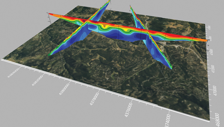
    I previously mentioned that the antenna of CORS TXLV was changed on August 5, 2021, so I used the option to plot the last five years to include data before and after the date the antenna was changed. I highlighted August 7, 2021, on both plots. This was two days after the antenna was changed on CORS TXLV.

    There appears to be a 2 cm upward shift in the up component after the new antenna was installed. There was also a change of about 1 cm in the north component. Something else to notice in the position plot is that the east component has a significant tilt during the five years. The below provides the ITRF2014 velocities — the eastward component velocity is —1.21 cm/year. In 5 years, one could expect to see about a 6 cm change.

    Position and Residual Plots for TXLV
    Position and residual plots for TXLV.
    Five-year position plot of TXLV.
    Five-year position plot of TXLV.
    Five year residual plot of TXLV.
    Five-year residual plot of TXLV.
    Position plot of TXLV for selected time interval
    Position plot of TXLV for selected time interval.

    These small changes affected my analysis and network adjustment results. During the past several years, I have participated in several Harris-Galveston Subsidence District (HGSD) GNSS projects performed in the Houston-Galveston, Texas, region. I have been involved with estimating subsidence in the Houston-Galveston, Texas, region for about 40 years so when I see changes in height values indicating an apparent uplift it makes me question my results. Therefore, I started investigating the CORS involved in the GNSS project. I looked at the Texas CORS surrounding the GNSS project: WHARTON CORS, COLUMBUS CORS, HEMPSTEAD CORS, LIVINGSTON CORS, and LIBERTY CORS.

    The table below provides the differences between the published ellipsoid height and the previous superseded height for the five CORS. As the table indicates, the published ellipsoid height of the CORS increased by about 2 cm from the superseded height. This led me to use the NGS NCN Station Pages to investigate these CORSs. I found that all five of these CORSs had new antennas installed in 2021 and their position plots depicted a similar shift.

    I want to emphasis that I am not saying that anyone did anything wrong or incorrect.  The CORS manager of these sites provided the appropriate metadata to the NGS CORS team so the site information could be updated and correctly reported. What this indicates to me is that the installation of the new antenna and setup may have affected the height component of these CORS, that is, it may have changed the official position of the monument’s reference point. Again, I want to emphasize that I am not saying that anyone did anything wrong or incorrect.  NGS’s process includes monitoring all CORS that are part of the NOAA CORS Network (NCN). The NGS CORS Team noticed the significant change in the up component comparing it to its expected value, so they computed a new coordinate and published the new coordinate in 2022. In my opinion, anyone using these CORSs as constraints in their GNSS projects after the date that the new antenna was installed and before the new coordinate was published could have generated adjusted heights that are in error by 2 cm. As previously stated, when you are estimating heights to the 2 cm level, changes in published NAD 83 (2011) CORS heights at the 2 cm level are significant. In my opinion, this type of analysis should be performed by all users that are incorporating CORS in their GNSS processing.

    CORS ID PID Station Name Published Ellipsoid Height (m) Published Date Date the New Antenna was Installed Date Station Coordinates Superseded Superseded Ellipsoid height (m) Difference Between Published and Superseded Heights (cm)
    txwh DL9086 WHARTON 8.615 04/22 4/28/2021 06/19 8.595 2.0
    txcm DL9812 COLUMBUS 45.481 04/22 3/17/2021 06/19 45.459 2.2
    txhe DH3608 HEMPSTEAD 48.823 04/22 5/06/2021 06/19 48.803 2.0
    txlv DN4508 LIVINGSTON 29.100 04/22 8/05/2021 06/19 29.075 2.5
    txli DH3612 LIBERTY -9.782 02/22 5/06/2021 06/19 -9.802 2.0

    Keep checking NGS beta site because NGS makes changes based on user feedback. As I previously stated, I would encourage everyone to access the beta site and provide your feedback to NGS. NGS states on the site that “This is a Beta product. We are interested in your feedback. Please email us at: [email protected] and indicate the subject as “NCN Station Pages Feedback.”  I have talked to the CORS team and they really would like feedback. The team will make changes to the website based on feedback from users.

  • Launchpad: UAVs, digital twin platforms and positioning modules

    Launchpad: UAVs, digital twin platforms and positioning modules

    A roundup of recent products in the GNSS and inertial positioning industry from the May 2024 issue of GPS World magazine.


    SURVEY & MAPPING

    Photo: Virtual Surveyor
    Photo: Virtual Surveyor

    UAV
    With planimetric survey capabilities

    The Virtual Surveyor version 9.5 now allows users to quickly and accurately survey 2D features from UAV orthophotos and add them to the 3D topographic model generated from the same data set.

    True 2D features, for example, include the paint striping that delineates parking lot spaces and road lanes. Other objects that exist in 3D on the ground but can be surveyed in two dimensions include building footprints and tree canopies. These features are designed to offer a new level of efficiency to the UAV surveying process in Virtual Surveyor.

    Virtual Surveyor provides users with an end-to-end workflow to conduct 3D surveys from UAV imagery. The integrated Terrain Creator app photogrammetrically processes UAV photos to build survey-grade digital surface models (DSMs) and orthomosaics. No third-party software is needed to create surveys from UAV data. The system is ideal for users in construction, surface mining and excavation projects.

    Learn more about Virtual Surveyor.

    Photo: Geneq
    Photo: Geneq

    Positioning System
    Incorporates an anti-jamming and interference monitoring system

    SXblue GLOBE merges GNSS and GIS to deliver positioning accuracy, efficiency and reliability in challenging field conditions using a 448-channel GNSS board.

    Its advanced multipath mitigation aims to reduce the effects of signal reflection and ensure the integrity of positioning service, even in GNSS-challenged environments. The SXblue GLOBE incorporates an anti-jamming and interference monitoring system, safeguarding against disruptions and offering uninterrupted operation in any scenario.

    The system uses global or local coverage of correction services, satellite-based augmentation system (SBAS), and real-time kinematics (RTK) with an update rate of up to 100Hz. This seeks to provide users with enhanced accuracy and reliability in positioning activities. Sxblue GLOBE features a Wi-Fi connection, which allows its parameters to be easily configured via a web user interface.

    Learn more about Geneq.

    Photo: Golden Software
    Photo: Golden Software

    3D Mapping Software
    With expanded visualization tools

    The Surfer mapping and 3D visualization software now features upgraded 3D visualization capabilities. The upgrades are designed to give users a complete picture of collected subsurface data. The expanded visualization tools in the latest Surfer version make it easier to create 3D grid files for viewing and analysis of drillhole data.

    Surfer can be used for environmental consulting, water resources, engineering, mining, oil and gas exploration and geospatial projects.

    With these upgrades, users can render 3D grids as a series of blocks, which can be colorized by a select variable. Images of cross sections, profiles and other features can be imported directly into 3D View and oriented in any direction or angle. To isolate certain features in the 3D grid, users can assign NoData to portions of the grid with a variety of methods. This allows users to eliminate unwanted data in a 3D grid outside of field boundaries, well locations, or above or below specific surfaces, such as a water table, topography, or lithologic layer.

    Learn more about Golden Software.

    Logo: Flow Labs
    Logo: Flow Labs

    Digital Twin Platform
    Shows roadway incidents in real time

    The Flow RT is a real-time digital twin platform designed to provide agencies with instantaneous alerts and insights for better decision-making. The platform allows traffic managers to view traffic conditions, signal operations and roadway incidents in real time, at scale across entire regions.

    Flow RT integrates seamlessly with the company’s solutions, including traffic signal management, roadway safety management and mobility management. Powered by connected vehicle data from industry-leading partners, including TomTom, the platform offers up to five times higher vehicle data penetration rate than the previous industry standard. Flow RT also provides alerts and notifications while offering data-driven decision support, ensuring agencies can make the best decisions using the most accurate, reliable and instantaneous insights with and without infrastructure connectivity.

    Learn more about Flow Labs.


    OEM

    Photo: Inertial Labs
    Photo: Inertial Labs

    INS
    With an integrated acoustic resonance air speed sensor

    Inertial Labs has integrated the FT Technologies FT743-D-SM acoustic resonance air speed sensor into its inertial navigation systems (INS).

    This integration aims to improve the accuracy of horizontal air speed estimation for multi-rotor UAVs, even in GNSS-denied environments. The FT743-D-SM airspeed sensor is a digital anemometer-based solution that can estimate airspeed incoming from any direction using acoustic resonance technology, which is immune to vibration and external acoustic noise. The airspeed magnitude and direction allow the INS to estimate horizontal air speed in the longitudinal and lateral axes.

    The INS receives aiding data from the dual-axis airspeed sensor and experiences significantly less position drift compared to a dead reckoning alternative in GNSS-denied environments, the company said. The system can be used in mission-critical roles in multiple military or defense applications, as well as in civilian applications such as wind energy, marine navigation, UAVs and dynamic positioning systems.

    Learn more about Inertial Labs.

    Photo: Telit
    Photo: Telit

    IoT Solution
    Designed for precision applications

    The SE868K5-RTK module is a GNSS receiver capable of centimeter-level accuracy. It is designed for seamless operation near cellular or other radios and is suitable for precision applications.

    At 11 x 11 mm, the module’s compact form factor offers adaptability in size-constrained scenarios and easy migration within the xE868 product family. It is designed to offer high-performance navigation, even in challenging RF conditions. The solution can be integrated into applications such as wearables, UAVs, robots, fleet tracking and precision agriculture.

    The SE868K5-RTK is a multifrequency and multi-constellation positioning receiver module with RTK capabilities that enhance positioning accuracy. By harnessing dual frequencies — L1/E1 and L5/E5 — the module offers improved location precision and reduces multipath effects.

    In partnership with Swift Navigation, the SE868K5-RTK module utilizes local base stations or Swift’s Skylark precise positioning service for corrections, which offers reliable centimeter-level accuracy across an extensive coverage area. The integration and Telit Cinterion’s cellular modules and NExT connectivity services offer continuous and accurate correction data delivery to the GNSS module.

    Learn more about Telit.

    Photo: MIKROE
    Photo: MIKROE

    Upgraded Click Board
    Now with an integrated GNSS receiver module

    The Septentrio mosaic-X5 GNSS receiver has been integrated into the MikroElektronika (MIKROE) Mosaic Click board.

    Mosaic Click is compatible with mikroBUS socket standard, allowing plug-and-play prototyping and reduced time-to-market. The mosaic-X5 receiver uses triple-band GNSS technology to achieve centimeter-level RTK accuracy, even in challenging environments. Its anti-jamming and anti-spoofing technology protects the receiver from malicious or accidental radio interference. It is ideal for applications where safety is a concern, as well as autonomous and mission-critical applications of systems such as UAVs or industrial robots.

    The mosaic-X5 receiver tracks all available GNSS constellations and is protected by Septentrio’s AIM+ anti-jamming and anti-spoofing technology. Full GNSS raw data and positioning are delivered at a high update rate of 100Hz and with low latency, which is critical for autonomous movement and maneuvering.

    Learn more about MIKROE.

    Photo: Systork
    Photo: Systork

    RTK Positioning Module
    Supports all GNSS constellations

    The Linnet mosaic-X5 is a multi-band module featuring the Mosaic-X5 receiver by Septentrio. It receives signals from all major constellations and can be used both directly on the rover and as a base station. The system can achieve centimeter-level positioning accuracy and attain precise positioning even in low-coverage zones and harsh vibrations and shocks.

    The mosaic-X5 module is a 448 channels all-in-view receiver that supports all GNSS constellations, SBAS and QZSS, as well as built-in on-module support for other L-band correction services. The Linnet Mosaic-X5 features anti-jamming protection and anti-spoofing built-in and embedded spectrum analyzer.

    The module can be used in a variety of applications, including tracking, surveying, autonomous navigation, ground robotics, precision agriculture and machine control.

    Learn more about Systork.

    Photo: AEVEX
    Photo: AEVEX

    Dual-GPS-Aided INS
    Completely autonomous

    Geo-hNAV is a rugged, hybrid dual-GPS-aided INS. It offers consistent position and attitude measurement accuracy whether the platform is static or moving. The Geo-hNAV combines the Geo-iNAV INS with the Geo-Pointer dual-antenna heading system.

    For stationary or slowly moving platforms, precise heading is derived from GPS measurements using two GPS antennas rigidly mounted on the platform, separated by a typical distance of 1 to 3 meters. In dynamic conditions, the combination of GPS and IMU seeks to provide enhanced position, velocity and attitude measurements. The system can be used for geo-positioning onboard sensors on static, low and high dynamic platforms such as aerostats, boats and tanks.

    Learn more about AEVEX.

    Photo: Hemisphere GNSS
    Photo: Hemisphere GNSS

    Smart Antenna
    Equipped for harsh environments

    The C631 is a multi-GNSS, multi-frequency smart antenna. The C631 provides robust performance and high precision in a compact and rugged package. With multiple wireless communication ports and an open GNSS interface, the C631 can be used in a variety of operating modes.

    C631 can be used as a precise base station sending RTK to existing rover networks. Users can turn the C631 into a lightweight rover by connecting it to a base via UHF radio or Wi-Fi network. The built-in web user interface can be used to control and manage the receiver status and operation and upgrade the C631 with new firmware and activations.

    Atlas is a global correction service that can be added as a subscription to the C631. Atlas delivers worldwide centimeter-level correction data over L-band communication satellites.

    Learn more about Hemisphere GNSS.


    MOBILE

    Photo: Quectel Wireless Solutions
    Photo: Quectel Wireless Solutions

    5G/GNSS Antennas
    For IoT devices

    The YEGB000Q1A and YEGN000Q1A active GNSS L1 and L5 antennas are designed to tap into L1 and L5 frequency bands for advanced navigation applications. These antennas, operating within the 1164-1189 MHz and 1559-1606 MHz frequency bands, are designed to support a variety of installation methods, catering to diverse application needs with options for screw mount, adhesive mount, magnetic mount and various cable connections.

    The antennas are part of a broader release that includes the YEMN016AA and YEMN017AA 5G 5-in-1 combination antennas, which also feature GNSS capabilities.

    These GNSS antennas are crucial for applications that require high levels of navigation accuracy, such as autonomous vehicles, UAV delivery systems and precision farming.

    Learn more about Quectel Wireless Solutions.

    Photo: Calian
    Photo: Calian

    Smart GNSS Antenna
    Minimizes RF impairments

    The TW5387 industrial-grade smart GNSS antenna integrates the Quectel ST TESEO V GNSS receiver chipset onto the Calian compact smart GNSS antenna platform. It is designed to offer dual-band GNSS, eXtended filtering, low phase center variation, low signal-to-noise ratio and dual feed and patch for strong multi-path rejection.

    The TW5387 comes with RTK rover capability and a built-in IMU for sensor fusion. It is designed to minimize RF impairments that affect the performance of the GNSS receiver and provide GNSS coordinates to the host system over a robust digital interface for noise resilience.

    TW5387 is suited for automotive, UAV, robotics and defense applications that require high precision location and timing. TW5387 is compatible with N-RTK correction services such as Point One Navigation’s Polaris and Swift Navigation’s Skylark. It tracks GPS, Galileo, BeiDou and L1/L5 band operation and is housed in an industrial-grade IP69K enclosure.

    Learn more about Calian.

    Photo: Pasternack
    Photo: Pasternack

    Multi-Band Antenna
    Designed for surveying

    The PEANGPS1005 is an active GPS/GNSS multi band L1/L2/L5 antenna with 47.5 dBi overall gain. It is IP69K rated, light weight and designed for surveying. This GPS/GNSS antenna is suited for harsh operating environments where stability and reliability of GPS/GNSS signal is required.

    This antenna operates in the 1.164-1.3GHz and 1.525-1.615GHz bands, meeting GPS L1/L2/L5, GALILEO E1/E6/E5a/E5b and GLONASS L1/L2/L3 requirements. The PEANGPS1005 antenna has an integrated LNA with 2 dB noise figure and LNA gain of 40 dB.

    The antenna has an axial ratio of 3 dB and can track visible satellites under extreme conditions, which is ideal for UAV navigation, autonomous tracking or GIS surveying.

    Learn more about Pasternack.


    MACHINE CONTROL

    Photo: Topcon Positioning Systems
    Photo: Topcon Positioning Systems

    Paving and Mining Solution
    Meets DOT smoothness standards 

    The MC-Max asphalt paving and MC-Max milling solutions offer modularity, simplified configurations and advanced feature sets to increase productivity in asphalt paving and cold milling applications.

    The MC-Max Asphalt Paving and MC-Max Milling systems, which are made up of , total stations, displays and other high-precision sensors, are built with the new MC-X machine control platform. Users can choose from entry-level 2D systems that follow a reference, such as a string or a curb, or automated solutions that track a paver or miller in 3D.

    Contractors can pave and mill at variable depths while meeting smoothness standards mandated by the U.S. Department of Transportation (DOT) smoothness standards. The solutions also include MC-X licensing options. The technology is compatible with OEM CAN-based systems and has expanded to include compatibility with additional aftermarket systems.

    It is equipped with Topcon Virtual Ski intelligence software designed to simplify workflows in specific resurfacing applications, such as rural roads where there are fewer fixed points or intersections to match up to.

    Learn more about Topcon Positioning Systems.


    UAV

    Photo: FlytBase
    Photo: FlytBase

    Reality Capture Platform
    Generates detailed 2D and 3D models

    This UAV reality capture platform collects data through FlytBase UAVs and generates detailed 2D and 3D models on SkyeBrowse, a UAV reality capture platform.

    The platform uses SkyeBrowse’s videogrammetry technology to quicly convert UAV video footage into 2D maps and 3D models, making it ideal for emergency response scenarios where rapid documentation is critical. The platform integrates seamlessly with beyond visual line of sight (BVLOS) systems, enhancing both the speed and quality of data-driven strategies in critical operations.

    Learn more about FlytBase.

    Photo: Event 38 Unmanned Systems
    Photo: Event 38 Unmanned Systems

    VOTL UAV
    Now featuring a 360-degree camera option

    The E400 fixed-wing VTOL ISR UAV now features a 360° camera option. Partnering with NextVision, the Event 38 UAV now offers a range of EO/IR Gimbal camera options for seamless integration with the E400 platform.

    NextVision’s gimballed EO/IR cameras capture visual and thermal imagery and video. The UAV provides live streaming directly to ground stations for continuous monitoring capabilities.

    The 360° EO/IR camera integrated onto the E400 ISR can be used for search-and-rescue missions, suspect pursuit, emergency management and disaster response. The E400 ISR, built with a military-grade carbon fiber frame, offers durability for rugged field applications and allows for extended flight durations without the need for frequent recharging. It is suited for surveillance and security applications. It features electric propulsion and minimal noise emissions for discreet flight operations.

    Learn more about Event 38 Unmanned Systems.

    Photo: Kongsberg Geospatial
    Photo: Kongsberg Geospatial

    Enhanced BVLOS System
    Offers situational awareness to UAS operators

    IRIS Terminal now features Echodyne radar technology designed to enhance Beyond Visual Line of Sight (BVLOS) operations for unmanned aerial systems (UAS) in Advanced Air Mobility (AAM) applications.

    The integration seeks to provide situational awareness to UAS operators by visualizing all airspace movement, cooperative and noncooperative, to ensure safe and reliable UAS operations.

    IRIS Terminal, now in its second generation, has been adapted from its defense origins to the enterprise UAS sector for visualizing airspace traffic, as well as controlling uncrewed systems in its GCS format. Airspace traffic is visualized inside IRIS Terminal’s multiple viewing configurations, along with features such as detect-and-avoid (DAA) sensor footprints, terrain awareness and potential conflict warnings.

    Learn more about Kongsberg Geospatial.

    Photo: Sony
    Photo: Sony

    Upgraded UAV
    With integrated lidar technology

    The Inertial Labs’ RESEPI lidar remote sensing payload instrument GEN-II has been integrated into Sony’s Airpeak UAV.

    The partnership seeks to enhance Airpeak’s ability to produce detailed aerial maps and 3D models.

    Tailored for professionals, the lidar system integrated into Sony’s Airpeak UAV will significantly enhance workflow efficiency and data accuracy, particularly in sectors such as construction, agriculture, and filmmaking, according to Inertial Labs. The system allows for extensive data handling and facilitates longer durations of data collection without frequent offloads. The UAV can be used for surveying, mapping and cinematic videography.

    Learn more about Sony.

  • Emlid, Pix4D launch mobile terrestrial scanning kit

    Emlid, Pix4D launch mobile terrestrial scanning kit

    Photo: Emlid
    Photo: Emlid

    Emlid has launched the Pix4D & Emlid Scanning kit. The kit combines advanced photogrammetry with real-time kinematics (RTK) precision for quick data capture when documenting trenches and as-builts, performing volumetric measurements and enhancing aerial data with terrestrial scans. It includes the PIX4Dcatch app and the Emlid Reach RX RTK rover.

    The PIX4Dcatch app is at the core of the kit’s software, which allows precise scanning for both photogrammetry and lidar projects. The hardware part features the Emlid Reach RX RTK rover, which is equipped with an ergonomic handle and accessories.

    It is integrated with PIX4Dcatch and provides real-time positioning via NTRIP. To begin scanning, users can select Emlid in the RTK settings of PIX4Dcatch and add their NTRIP network credentials.

    The kit works with any correction network (NTRIP) or a GNSS base station broadcasting RTCM3. The rover gets a fix in less than five seconds, offering centimeter-accurate positioning in challenging conditions. Apart from the scanning tasks, it can be used with the survey pole as an RTK rover for data collection and stakeout.

    Designed for urban surveying, the Reach RX rover is lightweight, rated IP68, sealed and protected from water and dust and features an industrial-grade battery, which offers 16 hours of work on a three-hour charge.

    The solution does not require additional setup or surveying skills. It is designed for professionals and non-surveyors in a range of applications, including underground utility documentation, construction inspection, volumetric measurements, crash reconstruction and combined aerial and terrestrial surveys.

    The PIX4Dcatch mobile app allows users to use a smartphone for scanning, access RTK precision data through integration with Reach RX and generate a digital model within minutes. Users can also store, annotate, measure and share data online in PIX4Dcloud as well as verify geolocated positions and visualize the project in AR. It extracts insights from both terrestrial and aerial data and features online and offline processing, advanced photogrammetry capabilities, team collaboration and AR for CAD overlays.

  • MSU developing CORS dashboard and geodetic program

    MSU developing CORS dashboard and geodetic program

    Photo: Dana Caccamise II
    Photo: Dana Caccamise II

    In my November 2023 GPS World newsletter, I highlighted the announcement made by the National Geodetic Survey (NGS) of the recipients of the National Oceanic and Atmospheric Administration (NOAA) FY 23 Geospatial Modeling Competition awards. The primary objectives of these projects are to modernize geodetic tools and models and to develop a geodetic workforce for the future. My last three GPS World newsletters — February 2024, March 2024 and April 2024 — highlighted three of the grantees, Scripps Institution of Oceanography, The Ohio State University, and Oregon State University that included developing models to address what NGS denotes as the Intra-Frame Deformation Model (IFDM) and creating geodesy curriculums that will help address the geodesy crisis. Changes in these geomatic programs will provide students with the skills in geospatial systems that will make available opportunities for employment in the public and private sectors. This newsletter will address the proposal by the fourth NGS geospatial modeling grant awardee, Michigan State University (MSU).

    First, it should be noted that this award is denoted as the MSU geospatial modeling award; that said, the execution of the project will be led by MSU, along with two sub-awardees — University of Alaska Fairbanks (UAF) and Michigan Tech University (MTU). Jeffrey Freymueller and Julie Elliott are the MSU grant’s principal investigators (PI). They provided me with information about the goals and objectives of their grant proposal.

    The MSU proposal includes enhancing software and monitoring capabilities for NGS, enhancing graduate-level geodetic education and providing opportunities for graduate and undergraduate students to be exposed to geodetic science. Again, focusing on geodesy curriculums will help address the geodesy crisis and will provide students with the skills in geospatial systems that will increase their opportunities for employment in the public and private sectors. The proposal has two main goals and objectives.

    Goals and objectives

    CORS Dashboard 

    • Build an online, web-based CORS dashboard that will support monitoring of the continuously operating reference station (CORS) network.
    • Making it easier to continually validate the current position of CORS sites to the existing motion models (IFDM).
    • To validate and correct the motion models themselves in the presence of time-dependent tectonic and volcanic activity.

    Education

    • Work with partner universities toward developing and establishing a consortium model for future distributed geodetic degree programs that leverage the capabilities and capacity of multiple universities.
    • Develop new course material for graduate level geodetic education that is intended for hybrid or asynchronous remote delivery and the establishment of a formal degree program.
    • Host summer undergraduate interns who will work on a variety of geodetic projects including the CORS dashboard.
    • Two graduate students will be supported to work on various aspects of the proposed work at MSU and MTU.

    Anyone using NGS’s “user-friendly” software knows that they are working on improving their web-based services. However, NGS still needs help from outside users.

    I want to emphasize that I am not criticizing NGS’s products and services. I worked for NGS for over three decades, and I personally know that NGS has limited resources to accomplish too many tasks. NGS needs to focus on the science and get help with the development of models, tools and the dissemination of results and data. That is one of the reasons that these geospatial modeling grants are important to all users of the National Spatial Reference System (NSRS).

    The proposed CORS Dashboard will be very useful to NGS employees monitoring the CORS and evaluating the IFDM. The proposal highlights that users of NGS products and services have various precision and accuracy requirements and that all users expect that NGS products will be sufficiently precise and accurate to meet their positioning needs. Their design of the CORS Dashboard will provide a tool for effectively monitoring and assessing a CORS site status and the validity of its coordinates. The first phase of this tool is being developed for internal use at NGS. However, in my opinion, after all the bugs have been identified and dealt with, NGS will release a version for the user.

    Not all CORS are created equal. So, having a CORS Dashboard that quickly identifies and notifies CORS users of a systematic deviation at a site, regardless of cause, will avoid promulgating erroneous positions to users. In addition, providing statistical information about a CORS site such as short- and long-term plots and their residuals would provide users with helpful information for planning a GNSS project. The metadata of CORS is extremely important since most of the CORS included in the NOAA CORS Network are not maintained by NGS.

    CORS managers are supposed to notify NGS when they make any change to their CORS site such as an antenna change and any changes surrounding the CORS site, including new vegetation or construction that could cause potential obstructions. The CORS Dashboard will help identify issues with CORS before users include them in their projects.

    NGS’s OPUS Project online user guide provides information on selecting the best CORS.  The following is from the user guide:

    • Using the centered time-series plots, select the candidates with RMS (in northing, easting, and up) less than 2 cm. Candidates with large spikes, data gaps or discontinuities should be rejected. Selecting candidates in this manner will provide some assurance that the published coordinates and velocities at the CORS agree with the daily solutions for the CORS.
    • The best CORSs should have “consistent” data depicted in 90-day short-term time-series plots. NGS processes each day of GNSS data collected at each CORS and plots the differences between the resulting coordinates and the published coordinates on short-term time-series plots (in terms of delta northing, easting, and up). These plots can be accessed for every CORS at https://geodesy.noaa.gov/corsdata/Plots/. CORS with plots that depict significant biases from the published coordinates (more than 2 cm in northing, easting, or more than 4 cm), spikes or data gaps should be avoided.

    NGS has developed a Beta CORS Time Series Tool that provides information that assists users in the selection of appropriate CORS for a project. The tool computes and displays the residual differences from the daily NGS OPUS-NET solutions with the coordinates from the official CORS’ coordinate functions. The tool also generates a summary table with the mean, standard deviation, and root-mean-square error of the residuals. On April 24, 2024, NGS announced the release of a beta version of a new NOAA CORS Network (NCN) Station Web Page. According to the announcement, each CORS in the NCN will have its own page with data, metadata, maps and photos for that station displayed in a modular layout so information is easily found all in one location. I will describe this new beta site in a future newsletter.

    The new, modernized NSRS will offer time-dependent coordinates based on an IFDM. This has been described in previous GPS World newsletters (February 2022 and August 2022). The MSU proposal includes developing a model that accounts for crustal movements — such as earthquakes, slow slip events, and volcanic eruptions, — as well as slower, cumulative growth of error due to post-seismic deformation, surface loading (ice or water changes) and changes in rates of human-induced subsidence due to fluid withdrawal. Like any model, the IFDM model will have uncertainties. Being able to provide a realistic estimate of the uncertainties of the IFDM is very important. The PIs of the proposal have extensive knowledge and experience in generating models and uncertainties. As noted in their proposal, the “problem” may not be an issue with the site or the equipment but with the model. See the box titled “Excerpt from the MSU Proposal.”  I have highlighted several sections that I believe are important to the users of the new, modernized NSRS.

    Excerpt from the MSU ProposalExcerpt from the MSU Proposal (2)

    As anyone who has been following my newsletters knows, I have been highlighting the geodesy crisis and programs that advance the science of geodesy — July 2020, November 2022, and December 2022. The proposal includes developing geodetic science courses that will be optimized for hybrid or asynchronous online courses that address advanced technical topics on GNSS, InSAR, map projections, reference frames, and adjustment theory. This will build on existing programs at MSU, UAF and MTU that will provide an online graduate degree in geodesy. MSU envisions this to be a step toward a consortium-based enhanced graduate-level education that provides a range of course options and flexibility. The university believes that there will be opportunities to expand the consortium in the future. The courses have not been finalized yet,  but below are some of the topics and concepts that are being considered for the program.

    Topics and Concepts
     

    Map Projections

    Map projections, geodetic datums, grid systems and transformations. Use of mapping software including GMT.


    Geodetic Models

    Course provides solid geospatial background in geodetic reference frames, datums, geoids and reference ellipsoids. 2D and 3D geodetic network adjustments are considered based on 3D spherical models.


    Modern Geodesy and Applications

    Modern geodetic methods including GPS, measuring steady or time-variable motions, the physical models that are used to interpret these observations and applications to active geological processes, the cryosphere and hydrology.


    Geodetic Methods and Applications

    Theory and application of modern geodetic tools to measure Earth’s surface deformation with emphasis on GPS and InSAR. Basics of data processing; evaluation of signals and modeling of their sources; applications include magma systems, earthquake cycle and hydro- and cryosphere. Labs in Python require programming experience


    Geodetic Data Processing and Analysis

    Course provides students hands-on experience in the selection, processing and analysis of geodetic data sets, particularly InSAR and GNSS. Selection of data from diverse sources, evaluation of data strengths and weaknesses, processing and analysis of data and application to the investigation of geological problems.
     

    Solid Earth Geophysics and Geodynamics

    Theory and applications of solid-Earth geophysics including geochronology, geothermics, geomagnetism and paleomagnetism, geodesy and gravity, rheology and seismology.


    Foundations of Geophysics

    Applications of continuum mechanics, heat flow theory and potential theory to geophysical, geologic and glaciological problems. Topics such as postglacial rebound, non-Newtonian fluid flow, thermal convection, stress-relaxation, rheology of Earth materials, gravity and magnetics will be discussed. Emphasis will be placed on methods and tools for solving a variety of problems in global and regional geophysics and the geophysical interpretation of solutions.
     

    Positioning with GNSS

    In-depth study of GPS, GLONASS, Galileo, COMPASS satellite systems; theory and processing of global positioning measurements.
     

    Intro Numerical Tools for Earth and Environmental Sciences

    Introduction to Linux and C including numerical methods, integration, curve-fitting and differential equations with an emphasis on applications to the geological sciences.


    Programming and Automation for Geoscientists

    Basic concepts of computer programming and effective task automation for computers, with an emphasis on tools and problems common to the geosciences and other physical sciences. Use of Python, Jupyter Notebooks, shell scripting and command line tools, making scientific figures, maps and visualizations.


    Data Analysis and Adjustments

    Course explores fundamentals of mathematical error propagation theory, including various observation equations, least squares adjustment and Kalman filter methods. Blunder detection, decorrelation and inversion of patterned large matrices processes are considered. Involves analysis of position estimation deploying geospatial measurements.


    Inverse Problems and Parameter Estimation

    An inverse problem uses observations to infer properties of an unknown physical model. This course covers methods for solving inverse problems, including numerous examples arising in the natural sciences. Topics include linear regression, method of least squares, estimation of uncertainties, iterative optimization and probabilistic (Bayesian) and sampling approaches.
     

    Numerical Analysis

    Direct and iterative solutions of systems of equations, interpolation, numerical differentiation and integration, numerical solutions of ordinary differential equations and error analysis.
     

    3D Surveying and Modeling with Laser Scanning Data

    Theory and application of terrestrial lidar scanning. Typical application scenarios are also included. Intensive lab component provides hands-on experience in lidar point cloud processing and visualization.


    Advanced Photogrammetry – Satellite Photogrammetry

    Fundamentals of spaceborne imaging systems relevant to topographic mapping. Imagery products —preprocessing levels and metadata. Specific methods of space photogrammetry. Review of contemporary spaceborne imaging systems and imagery products available. Airborne non-frame sensors and photogrammetric processing of the imagery.


    Microwave Remote Sensing

    The principles and applications of active and passive microwave remote sensing with emphasis on spaceborne remote sensing of the Earth’s atmosphere, land and oceans. The laboratory section will provide hands-on experience on special processing techniques and the possibility of using these techniques for a student-defined term project in areas of geology, volcanology, glaciology, hydrology and environmental sciences


    InSAR and its Applications

    Introduction to the concepts of repeat-pass spaceborne SAR interferometry. Practical use of the technique to derive displacements of the solid Earth, glaciers and ice sheets to a precision of a few centimeters and accurate digital elevation models of the Earth’s surface.

    As previously stated, these courses have not been finalized. An important aspect of the courses is that they contain content that will provide students with the skills and knowledge in geodetic concepts to help address the geodesy crisis in the United States.

    I first mentioned the need for more trained geodesists in my July 2020 article for the “First Fix” column of GPS World, where I stated that the shortage of U.S.-trained geodesists poses a significant economic risk for the United States. In that column, I mentioned how geodetic science and technology now underpin many sciences, large areas of engineering such as driverless vehicles, UAVs, navigation, precision agriculture, smart cities and location-based services.

    My November 2022 GPS World Newsletter highlighted “The inverted geospatial pyramid” graphic, which depicts how the entire $1 trillion geospatial economy is supported and dependent on geodesy. A lack of geodetic expertise in the United States presents a significant challenge, with future impacts on positioning, navigation, mapping and dependent geospatial technologies. These changes in the geomatic programs at the universities being funded by NGS’s geospatial modeling grants will provide students with the skills in geodetic concepts that will provide opportunities for employment in the public and private sectors involved with geospatial technology.

    This newsletter and my past three GPS World newsletters highlighted the four NGS Geospatial Modeling grantees, which included creating geodesy curriculums that will help address the geodesy crisis. The MSU proposal describes a consortium-based enhanced graduate-level education program that will provide a range of course options and flexibility. I believe their proposed hybrid or asynchronous online program will provide more opportunities for individuals to study geodesy and advance the science of geodesy.

    One final note about the NGS Geospatial Modeling Grants. On June 4, 2024, Brad Kearse, director of NGS, will moderate a session at the UESI Surveying and Geomatics 2024 Conference held in Corvallis, Oregon, on June 4 to 5, 2024. This will be a good opportunity for participants to obtain a better understanding of the geospatial modeling grants.

    Lunch & panel discussion: NGS Geospatial Modeling Grants panel session

    Moderator: Brad Kearse, Acting Director, NGS

    The NGS Geospatial Modeling grant program is focused on modernizing and improving the National Spatial Reference System (NSRS) and address emerging research problems in the field of geodesy. A secondary objective of this funding opportunity is to support a geodesy community of practice in collaboration with federal and nonfederal stakeholders to address the nationwide deficiency of geodesists and improve the coordination and use of geospatial data. This panel session will explore the research and other activities underway from recipients of the most recent round of the NGS Geospatial Modeling Grant Program.

  • Launchpad: Rotating lasers, antennas and upgraded UAVs

    Launchpad: Rotating lasers, antennas and upgraded UAVs

    A roundup of recent products in the GNSS and inertial positioning industry from the April 2024 issue of GPS World magazine.


    SURVEYING & MAPPING


    Photo:

    Rotating Laser
    Built for challenging worksites

    The Zone40 T one-button rotating laser is designed for all types of grading and leveling jobs. It seeks to address the industry’s need for efficient and accurate alignment solutions.
    Its one-touch operation is designed to simplify and increase efficient workflows in a variety of jobs such as grading, paving, excavating, surveying, layout and more. It is ideal for contractors, crew chiefs, supervisors and trade professionals.

    GeoMax products are tested and proven to endure the toughest conditions. With an IP67 environmental rating, the Zone40 T accurately delivers in dust, water, wind and extreme temperatures.
    GeoMax Positioning, geomax-positioning.com

    Photo:

    Hydrographic Surveying Solution
    With advanced inertial sensors

    The Seapath 385 navigation system is designed to enhance precision in hydrographic surveying by using advanced navigation algorithms and integrating a range of satellite signals, including GPS, GLONASS, Galileo, BeiDou and QZSS, alongside geostationary satellite signals. The Seapath 385 system combines raw inertial sensor data from Kongsberg Discovery’s high-performance motion gyro compass (MGC) or motion reference unit (MRU) with GNSS data and corrections from real-time kinematics (RTK), precise-point positioning (PPP) or Differential Global Navigation Satellite System (DGNSS). The integration offers a robust and accurate navigation solution ideal for hydrographic surveying.

    The system’s dead reckoning capabilities are attributed to its advanced inertial sensors and updated navigation algorithms. It uses GNSS antennas for both positioning and heading determination designed to add an extra layer of robustness to the system. The Seapath 385 also introduces a new post-processing format that consolidates all necessary data and system configurations into a single file, which allows for centimeter-level position accuracy through either satellite orbit and clock data or data logged from base stations.

    Designed for ease of installation and continuous, reliable operation, the Seapath 385 is a modular system with a processing unit that handles all critical computations independently of the user interface on the HMI Unit. This feature offers precise measurements with a data rate of up to 200 Hz at multiple monitoring points, which makes it an ideal solution for accommodating sensors or systems that depend on motion or position data throughout the vessel.
    Kongsberg Discovery, Kongsberg.com

    Teledyne Geospatial

    Marine-Grade Sensor
    Compatible with USVs

    The Optech CL-360 Marine is a 360° long-range laser scanner. It combines a scan speed of 250 lines per second with 2 mm range resolution, a plug-and-play solution and an IP67 marine-grade sensor.The system can be seamlessly integrated with multibeam systems and the CARIS Ping-To-Chart workflow, which allows for full above-and-below-water image capture with survey-grade accuracy in a single workflow.It is ideal for mapping coastal infrastructure and is designed to be used on an uncrewed surface vessel (USV) that provides survey grade range and accuracy.
    Teledyne Geospatial, teledyneimaging.com

    Photo:

    GNSS Receiver
    Designed for centimeter-level and RTK accuracy

    The HiPer CR is a compact and lightweight GNSS receiver designed for centimeter-level and RTK accuracy for professionals in a wide range of applications in surveying, construction, engineering, forestry and mining. It joins a portfolio of fuller-featured receivers, including the HiPer HR and VR.

    The HiPer CR tracks the GPS, GLONASS, Galileo, BeiDou and QZSS constellations. It can be used in a variety of configurations, including as a network RTK rover, in base and rover setups and in integrated hybrid use with a robotic total station.

    When used as a network rover with Topnet Live — the company’s global GNSS correction service — the HiPer CR will have access to high-quality data corrections to increase efficiency and productivity. Users also can select to use the receiver as part of a hybrid positioning system, which allows users to use a robotic total station for prism measurements. Users also can switch to GNSS measurement with the HiPer CR for obstructed areas such as warehouses, trailers, or buildings.
    Topcon Positioning Systems, topconpositioning.com


    Image: CHCNAV

    Handheld SLAM laser scanner
    For in the field and indoors

    The RS10 is a handheld SLAM lidar laser scanner integrated with a full real-time kinematics (RTK) GNSS receiver.
    Designed to improve efficiency across a wide range of mapping and surveying applications, the RS10 seeks to provide professionals with a versatile, all-in-one tool for capturing 3D geospatial data in both outdoor and indoor environments.

    The RS10 integrates a GNSS smart antenna for RTK positioning accuracy even in challenging environments. It delivers 5 cm measurement accuracy by fusing high-precision lidar, RTK, laser and visual SLAM using three HD cameras.
    The RS10 uses a powerful onboard processor for real-time georeferenced point cloud generation in the field. Users can receive instant feedback, which allows them to adjust while scanning. Large sites up to 13,000 square meters can be mapped in real time.

    The integration of high-precision GNSS and SLAM technologies eliminates the need for traditional loop closure, which often complicates the data collection process for handheld scanners. Users can freely scan target areas without having to return to previous locations, which can streamline field data capture and significantly reduce time spent in the field.
    CHC Navigation, chcnav.com

    Photo:

    Airborne lidar sensor
    With scan pattern reconfigurability

    The Leica TerrainMapper-3 airborne lidar sensor features a new scan pattern reconfigurability to support a variety of applications and requirements in a single system.

    The system offers three scan patterns, which allow users to customize the sensor’s performance to fit specific applications. Its circle scan patterns are designed to improve 3D modeling of urban areas or steep terrains. The ellipse scan patterns use data capture for more traditional mapping applications. Skew ellipse scan patterns are aimed at improving point density for infrastructures and corridor mapping applications.

    The sensor has a high scan speed rate and a 60° adjustable field of view to maximize data collection with fewer flight lines. The TerrainMapper-3 is complemented by the Leica MFC150 4-band camera, which operates with the same 60° field of view coverage as the lidar for exact data consistency.

    The device’s reduced beam divergence offers more accurate results, while its new multiple pulses in air (MPiA) handling is designed to deliver more consistent data acquisition, even in steep terrain.
    The system introduces possibilities for real-time full waveform recording at a maximum pulse rate to open opportunities for advanced and automated point classification.
    Leica Geosystems, leica-geosystems.com

    Photo: Trimble Geospatial

    Mobile Mapping Solution
    Mounted on vehicles or trains

    The Trimble MX90 mobile mapping system integrates advanced Trimble GNSS and inertial technology with Trimble field and office software. It offers users a comprehensive field-to-finish mobile mapping solution designed for robust workflows for data capture, processing and analysis.

    The MX90, mounted on vehicles or trains, captures detailed laser scans and imagery —panoramic and multi-angle. This data, collected at highway speeds, undergoes rapid processing to produce deliverables for feature detection and inspections.

    The mobile mapping system includes immersive 360° panoramic and targeted cameras to capture high-resolution imagery of various details, such as small or distant road and rail signs, telecommunications towers or cracks and holes in roads.

    Additionally, it offers high-density colorized point clouds with rich and accurate color projections. These dense point clouds, along with high-resolution imagery — panoramic and planar — and accurate trajectories, provide the basis for a wide range of deliverables, including street scenes, road and rail asset details, elevation models, volume calculations, 3D city models and as-built surveys.

    It features a high-end inertial measurement unit (IMU) combined with IN-Fusion+ data processing technology to achieve high-quality data in challenging GNSS environments. The MX90 also comes with reliable office software solutions to support multiple use cases and applications, such as road inspection workflows and integration into cloud-based applications for efficient data sharing.
    Trimble Geospatial, geospatial.trimble.com

    Photo:

    Collaborative Mapping Tool
    With spatial analysis features

    Felt 2.0 is a collaborative mapping tool with powerful data transformation tools. Now with spatial analysis features, users can manipulate and analyze geographic data. It has web-based collaboration features designed to make mapping workflows interactive and accessible across organizations.
    The software uses artificial intelligence (AI) to deliver faster workflows for geographic information systems (GIS) professionals. Users can utilize Felt’s Upload Anything capabilities to visualize any file format. The system will read, understand and deliver an internet-fast visualization to the users’ workspace. The software is available for download on tablets and other mobile devices.
    Felt, felt.com

    Image: savvy navvy

    Automatic Identification System
    Available on Android, IOS, PC and Mac

    The Over the Horizon (OHA) automatic identification system (AIS) is the newest update to the savvy navvy app. The update uses a phone’s internet connection to stream other vessels’ locations in real-time directly to the app to improve safety on the water.

    Traditional AIS received from the transceiver on the boat has a range of a few miles, whereas OHA is designed to show vessels further afield. While OHA does require an internet connection, users do not need additional hardware to see information on vessel movements.

    OHA AIS allows users to see vessels directly on the chart with small and large vessel crafts defined by different colors. Users can also check how crowded an anchorage might be — either from onboard or while planning routes at home.

    The savvy navvy application highlights when no position has been received for more than 30 seconds, which marks the positional variance area around each vessel and allows users to be extra vigilant when navigating.
    Available on Android, IOS, PC and Mac, the savvy navvy app can be used on multiple devices and is available in both free and “premium” options with enhanced access and functionalities.
    savvy navvy, savvy-navvy.com


    UAV

    Photo:

    Real-Time Command and Control System
    Supports BVLOS

    VigilantHalo is a software-based platform designed for real-time command and control of uncrewed airspace. The system supports a wide range of missions from air traffic control (ATC) to beyond visual line-of-sight (BVLOS) operations and counter-uncrewed aerial systems (C-UAS).
    VigilantHalo combines radar and multi-sensor surveillance technology into a comprehensive situational awareness solution. It is designed for disaster response and critical infrastructure defense and can be customized for specific mission requirements. The system’s flexibility allows deployment across cloud, mobile or fixed-site installations, which aims to address the evolving threats in national security and the National Airspace System (NAS).

    The system features integrated data processing, a fusion tracker and a communications system that enables operators to monitor and manage air traffic under various conditions. It leverages weather analytics from the National Oceanic and Atmospheric Administration (NOAA) and other sources to assess flight paths and identify safety risks. VigilantHalo uses a custom sensor data processor (SDP) that integrates data from different sensors and surveillance feeds into a unified display tailored to specific missions such as ATC, BVLOS, air defense and more.
    BlueHalo, bluehalo.com

    Photo:

    Dynamic Channel Switching
    Improves communication in the field

    The Skydio X10D UAV features dynamic channel switching to monitor signal interference and move to a clearer channel. This aims to improve wireless transmission signal quality during flights to ensure troops maintain communication with the UAV to accomplish their mission.
    Dynamic channel switching allows the X10D to provide adaptable communications between the drone and its accompanying controller in situations where the airspace is congested or under electronic warfare conditions. This feature ensures that reliable command and control is maintained and real-time data feeds are available even in challenging conditions.

    The X10D is designed for intelligence, surveillance and reconnaissance (ISR) applications critical to defense and government agencies. It delivers advanced sensor technology, autonomous navigation and a modular, open architecture for military needs.

    Skydio’s onboard AI and autonomy for small unmanned aircraft systems (sUAS) offers obstacle avoidance in zero-light environments and autonomous flight. Skydio X10D delivers enhanced compliance with federal standards, including the Robotics and Autonomous Systems – Air (RAS-A) Interoperability Profile (IoP) and an open, modular platform that supports third-party applications. RAS-A compliance and open MAVLINK protocol enable the use of third-party and government-owned flight application software.
    Skydio, skydio.com

    Photo:

    Lidar Sensor
    Integrates with UAVs

    The JoLiDAR-1000 is a new lidar sensor for UAVs. It aims to improve applications in GIS, surveying, and precision inspections of power lines. The JoLiDAR-1000 incorporates advanced lidar technology to improve measurement accuracy for UAV applications.

    The sensor features a 1,000 m medium-range laser scanner, using RTK and inertial measurement unit (IMU) fusion technology and laser scanning for enhanced measurement precision. It achieves a measurement accuracy of 5 mm, a repetition accuracy of 10 mm and a line scanning speed ranging from 10 lines to 300 lines per second. It has a 100° field of view and an angular resolution of 0.001 to precisely detect objects at extended distances.

    Designed with compact dimensions and weighing only 1.9 kg, the JoLiDAR-1000 is portable and integrates seamlessly with various UAV platforms. It incorporates a suite of technologies, including a GNSS high-precision positioning system, IMU, high-speed data acquisition systems, time synchronization systems and a 26MP RGB camera to enhance its data collection capabilities.
    The JoLiDAR-1000 streamlines operational processes by eliminating the need for base station setup and ground control points. It is equipped with high-precision POS solution computation and point cloud fusion capabilities. The sensor is suitable for a wide range of applications such as terrain mapping, power line inspection, mining surveying, coastline measurement, emergency mapping and natural resource surveying.
    JOUAV, jouav.com

    Photo:

    AI Autopilot
    Designed for USVs

    The Voyager AI Autopilot converts newly built or retrofitted unmanned surface vessels (USVs) into fully autonomous craft.
    The Robosys Autopilot module seamlessly integrates with Robosys’ Voyager AI Survey as part of the Voyager AI software suite. It enables remote and autonomous heading and speed control as well as various other mission modes for navigation and vessel control, specifically for hydrographic and oceanic surveying operations.

    The marine autopilot is designed to meet the demands of 3 m to 12 m electric drive surveys. It is easily scalable to full advanced autonomous navigation, which seamlessly integrates with third-party steering, drive and motor control systems to provide optimal vessel functionality for USVs and other craft.
    Robosys Automation, robosysautomation.com


    OEM

    Photo:

    Satellite Positioning Chips
    With AEC-Q100 Grade 2 reliability qualification

    Designed for automotive applications, the AG3335MA satellite positioning chip series has earned AEC-Q100 Grade 2 reliability qualification. The AEC-Q100 is designed to ensure reliability and safety beyond the requirements for consumer electronics.
    The AG3335MA series chips have been certified by a third-party quality management system equipped with an automotive specification laboratory. Achieving Grade 2 certification, these chips are tested for operation in extreme temperatures ranging from -40°C to 105°C, which caters to the demanding environments of automotive applications.
    The AG3335MA features ultra-low power consumption, high endurance and dual-frequency capability. It supports the five major global satellite systems and NavIC to ensure reliable operation in a broad temperature range and challenging weather conditions. Its GNSS receiver measurement engine has a satellite tracking sensitivity of -167 dBm and a cold boot positioning time of 25 seconds. This allows it to receive and process signals from all visible satellites simultaneously, offering increased accuracy in positioning.
    Airoha Technology, airoha.com

    SOM-SMARC Modules
    Powered by Qualcomm

    The Smart Mobility Architecture (SMARC) System on Modules (SoMs) are based on Qualcomm QCS6490 and Qualcomm QCS5430 application processors. These new SMARC modules are the first results of SECO’s strategic collaboration with Qualcomm Technologies, announced in September 2023.
    The SOM-SMARC-QCS6490 is designed to simplify the use of the Qualcomm QCS6490 processor. The chipset offers support for artificial intelligence (AI) and computing, robust performance at low power and expanded interfaces and peripherals catering to diverse industrial use cases.
    The Qualcomm Adreno 643 GPU offers enhanced graphics performance and energy efficiency. It supports FHD+ at 120 fps resolution on primary and secondary displays up to 4k Ultra HD at 60 Hz. The SOM-SMARC-QCS6490 supports Microsoft Windows 11 IoT Enterprise, Yocto Linux and Android, with both commercial (0°C to +60°C) and industrial (-30°C to +85°C) temperature variants available.
    The SOM-SMARC-QCS5430, powered by the Qualcomm QCS5430, is a mid-tier solution that slightly moderates CPU and GPU performance. This system-on-chip (SoC) combines enhanced connectivity, performance and edge AI-powered camera capabilities. It also provides scope for field software-based upgrades of the CPU and GPU by using the processor’s capabilities.
    SECO, seco.com

    Photo:

    INS
    Featuring FOG-based IMU

    The Phins 9 Compact is a high-performance inertial navigation system (INS) designed for all unmanned underwater vehicles. It offers a blend of navigation performance, reliability and size, weight and power (SWAP) efficiency.
    The Phins 9 Compact is built around a high-performance fiber-optic gyroscope (FOG)-based IMU with advanced accelerometers. With compact dimensions, a DVL-aided position accuracy of 0.1% TD, and a power consumption of less than 7 W, it is ideal for compact subsea vehicles in demanding applications with low power requirements.

    The INS aims to redefine the standards of subsea navigation in a wide range of applications, including survey-grade coastal and offshore seabed mapping, inspection repair and maintenance (IRM), defense and more.
    Exail, exail.com


    MOBILE

    Image: Abracon

    GNSS FR Antennas
    Supports a full spectrum of bands

    This series of GNSS RF antennas is designed to elevate location-based services with enhanced accuracy and precision. This new lineup aims to outperform conventional GPS technologies by offering faster signal acquisition, improved tracking capabilities and reduced power consumption.
    The antennas support a full spectrum of bands, including L1, L2, L5, and L-band data correction services. It can be used in a variety of sectors, such as agriculture, surveying, the Internet of Things (IoT), mapping, defense and aviation.
    The technology is designed to meet the rigorous demands for precise location data across various applications. These antennas offer multi-band and multi-constellation support to ensure broad compatibility. With centimeter-level accuracy, these antennas are crucial for aerospace, defense, asset tracking, geolocation, precision agriculture and industrial IoT.
    Abracon, abracon.com

    Image: SparkFun Electronics

    Iridium on the Go
    Magnetic mount antenna

    The 2J7426MPz by 2J antenna is a high-performance magnetic mount antenna that is designed specifically to communicate efficiently with the Iridium satellite communication system. It is manufactured with high-quality polycarbonate (PC) and acrylic-styrene-acrylate terpolymer (ASA), a thermoplastic combination that offers strong resistance to UV, moisture, and heat and enhances mechanical properties.
    The antenna housing is waterproof to IP69 standards and designed to operate in extremely harsh environments, including those with frequent exposure to water, dust and debris. It has a recommended operational and storage temperature of -40°C to +85°C. The magnetic mount allows for easy installation and removal between vehicles or assets, and it is easily converted to an adhesive type for greater flexibility.
    It is delivered with a standard SMA-male connector and a standard 300 cm long coaxial LL100 cable. Iridium has certified the 2J7426MPz antenna for commercial use in connection with the Iridium communications system.
    SparkFun Electronics, sparkfun.com

  • Virtual Surveyor upgrades UAV surveying software

    Virtual Surveyor upgrades UAV surveying software

    Photo: Virtual Surveyor
    Photo: Virtual Surveyor

    Virtual Surveyor has enhanced its smart UAV surveying software with new planimetric survey capabilities. The Virtual Surveyor version 9.5  allows users to quickly and accurately survey 2D features from UAV orthophotos and add them to the 3D topographic model generated from the same data set.

    True 2D features, for example, include the paint striping that delineates parking lot spaces and road lanes. Other objects that exist in 3D on the ground but can be surveyed in two dimensions for many applications are building footprints and tree canopies. These features are designed to offer a new level of efficiency to the UAV surveying process in Virtual Surveyor.

    Virtual Surveyor provides users with an end-to-end workflow to conduct 3D surveys from UAV imagery. The integrated Terrain Creator app photogrammetrically processes UAV photos to build survey-grade digital surface models (DSMs) and orthomosaics. These transfer seamlessly to the traditional Virtual Surveyor app where users perform the real survey work — generating CAD models, creating cut-and-fill maps, calculating soil volumes and deriving other 3D topographic information.

    No third-party software is needed to create surveys from drone data. The system ideal for users in construction, surface mining and excavation projects.

    These new functions include:

    • Move/copy – Once the feature, such as a paint stripe, has been surveyed, it can be copied and moved to delineate the next stripe. If the stripe bends along a turn in a road, this function lets the user rotate the feature to follow the curve. When multiple nearly identical objects, such as parking space stripes, have been surveyed, they can be moved to survey another group of stripes.
    • Diagonal first rectangle drawing – Users can simply click on diagonal corners, and the object is delineated and surveyed.
    • Edit side –As features are being copied, this tool allows the user to edit the feature sides.
    • Mini toolbars – Users can right-click on a feature, and a mini toolbar with the relevant tools pops open next to it for easy capture or editing.

    Current subscribers to Virtual Surveyor Ridge and Peak editions will see their software updated automatically to Version 9.5 with the planimetric tools and other new functionality. Click here to learn more and download the software.

  • Calian introduces smart GNSS antenna

    Calian introduces smart GNSS antenna

    Photo: Calian
    Photo: Calian

    Calian GNSS, formerly Tallysman Wireless, has released its TW5387 industrial-grade smart GNSS antenna. It integrates the Quectel ST TESEO V GNSS receiver chipset onto the Calian compact smart GNSS antenna platform to offer dual-band GNSS, eXtended filtering, low phase center variation, low signal-to-noise ratio and dual feed and patch for strong multi-path rejection.

    The TW5387 comes with RTK rover capability and a built-in IMU for sensor fusion. It is designed to minimize RF impairments that affect the performance of the GNSS receiver and provide GNSS coordinates to the host system over a robust digital interface for noise resilience.

    TW5387 is suited for automotive, UAV, robotics and defense applications that require precise location and timing. TW5387 is compatible with N-RTK correction services such as Point One Navigation’s Polaris and Swift Navigation’s Skylark.

    It tracks GPS, Galileo, BeiDou and L1/L5 band operation and is housed in an industrial-grade IP69K enclosure.

  • Comnav upgrades survey software

    Comnav upgrades survey software

    Image: Comnav
    Image: Comnav

    Comnav Technology has released the latest version of its Survey Master software — Survey Master 3.5.0.

    The software includes an enhanced super CAD engine. A measurement grade has been added to the CAD to improve the software’s utility in design and planning projects. Additionally, the latest version features expanded CAD drawing and survey functions to offer users a comprehensive toolset — including point, line, polyline, curve, arc, square, rectangle, polygon, circle and text.

    Survey Master 3.5.0 also has added CAD capture mode from any point and allows users to easily display or hide point icons. It can also open drawings in CAD to display progress and detailed selection element information.

    The system added the Dominican predefined coordinate system, SBAS configuration, PPP and RTK PPP fusion, updated satellite frequency and an external datalink CDL7 configuration.

    Existing software users can update directly in Survey Master. Click here to download the software.

  • Per Vices: Flexible radios help autonomous systems interface

    Per Vices: Flexible radios help autonomous systems interface

    An exclusive interview with Brandon Malatest, co-founder and  COO of Per Vices 


    What is your title and role?

    I’m one of the founders of Per Vices. My friend and I started the company a long, long time ago. I’m a physicist. I attended the University of Waterloo, graduated with an honors degree in physics, and have been working with Per Vices for more than ten years. My role has shifted from doing the actual engineering work to running all the other elements of the company, because as we continue to grow, we can’t be doing everything and that was the logical break. So, I definitely have a technical background, but I’m not the one who’s designing the products anymore.

    When was the company founded?

    In 2006. Our first commercial product was in 2012. We specialize in designing high performance software-defined radios. These are full transceivers that are used across a very wide range of markets: spectrum monitoring, electronic warfare, MRI, radar, test and measurement markets, communications, radio links — you name it and we’ve done some work in that space. The whole idea behind software-defined radios is that they are very flexible systems. So, with the same hardware platform, you can change the software or firmware, and have it used for a completely different application.

    Wonderful. By the way, I grew up among physicists. My father was a physicist for 60 years, the last 35 of which at Brookhaven National Laboratory on Long Island. My paternal grandmother was one of the first women in Europe to get a Ph.D. in physics and math and Enrico Fermi was one of her thesis advisors.

     Why is SDR important for autonomous systems?

    There are eight major points that I’d like to hit on.

    Flexibility. Software-defined radios are reconfigurable, which means that the same hardware platform can be used for many different communication protocols, across different radio bands with varying bandwidth. That makes them very flexible for interfacing with other types of systems. So, in terms of the autonomous systems, there are a number of different wireless devices that need to be interoperable.

    SDRs are very flexible radio platforms. They’re designed to have very wide operating frequencies with varying bandwidths so as to replace what used to be done in hardware through dedicated DSP chips, replacing dedicated hardware with a software-based architecture.

    From a flexibility standpoint, that means that software-defined radios usually use some type some type of DSP mechanism, like a field programmable gate array (FPGA). That allows the SDR itself to process all types of different signals across varying frequencies and manipulate them in different ways. Anything that’s wireless is basically converting an analog signal to a digital signal and then performing some action on that digital signal. SDRs do that in a different way. They still have the hardware that’s used for tuning, but on the software side the decoding and processing happens. In a traditional FM radio, you have everything done in hardware: it has a dedicated tuning block, a dedicated DSP that does the demodulation, and it spits out the audio. So, the same way that computers, way back in the day, were designed and built from the ground up with one sole purpose — whether it be word processing or running complex trigonometry.

    But now, if you look at the utility of computers, it is the fact that you can run different software applications on them. So, the same idea is with SDR. Traditional radio devices were built from the ground up for a single application. Now, SDRs are like a modern-day computer, where you can do basically anything within that tuning frequency. Also, just like with a computer, you change the software and use it for different applications.

    Flexibility is definitely one of the most important elements. It allows the user or the system integrator to have an SDR that can adapt to different communication standards and frequency bands. This flexibility is crucial for autonomous systems operating in dynamic environments, where communication requirements may change. So, if you’re suddenly needing to change from operating at 2.4 GHz to operating at 5 GHz due to spectrum congestion or something along those lines, an SDR can do that with the same hardware platform.

    Photo:YellowScan’s bathymetric lidar product, the Navigator, mounted on the Noa from Acecore. This full waveform lidar system ensures continuity between underwater points and the surrounding terrain.(Image: YellowScan)
    YellowScan’s bathymetric lidar product, the Navigator, mounted on the Noa from Acecore. This full waveform lidar system ensures continuity between underwater points and the surrounding terrain.(Image: YellowScan)

    Adaptive communication. Because SDRs tune to various frequency bands and then all the decoding is done in software, they can support different communication standards with the same hardware platform. That enables autonomous systems to communicate effectively with various entities in the environment, such as sensors and additional equipment.

    Spectrum awareness. We can call it smart SDRs, or SDRs where you can integrate with AI or you can do your own pre-programming on it. You can monitor different parts of the spectrum to see which is the least congested, so that you can have a clear frequency band of operation to communicate or to use that information for passing data to and from sensors or a command and control system or anything.

    Going back to the hardware component, the FPGA onboard acts as a digital signal processing unit. So, SDRs have those onboard DSP units — usually, FPGAs — and that allows for such things as signal modulation and demodulation filtering, waveform generation. All this can be done in real time. It also allows for all the sensor data to be processed very effectively and quickly, with significantly reduced latencies.

    Reduced hardware complexity. This relates to putting it all together. When you have the DSP unit and the flexible hardware platform, you don’t really need anything else. So, you can use that SDR to minimize the complexity associated with the overall system. When you’re using multiple disparate technologies, it does become challenging to make sure that they’re all integrated well with one another and work well together. With SDRs, you can really simplify that, that hardware complexity. Then, because SDRs are programmable and customizable, they can be used all the way from prototyping to production. By changing different software or firmware elements associated with the SDR, you can have it operate in different ways. So, if you want to prototype a different communication band that may work better for some environments, you can do that very easily without needing to re-spin new hardware upon new hardware upon new hardware, which gets to be costly and time-consuming.

    Remote monitoring and control. SDRs can be set for what we’ll call static operation, where they will perform only one task, to prevent tampering. You can also set them to be updated over the air or through some type of network. So, again, the flexibility is quite significant and it’ll allow you to mitigate different challenges where some of the systems might not be able to be controlled or interfaced regularly from a hardware perspective. That can all be encrypted.

    How does your module interface with autonomous platforms?

    The analog connection — to external amplifiers or filters, if you need to have very clean use of a particular part of the spectrum — is via SMA connections, which are pretty standard in the industry. On the digital side, there are two different ports. One is an out-of-band communication interface. That’s just a 1 GB Ethernet port that is very common across the entire industry and is used for configuring the SDR. Again, that’s out of band, so you’re not causing any interference with the actual operation. The other one is the digital interface for sending data to and from the system. That can be done over a 10 G interface, a 40 G interface or a 100 G interface, depending on the platform, how much bandwidth you need, etc.

    What is your market at this point?

    We don’t discuss our customers specifically, because often they are either very large commercial entities that don’t like to have their names disclosed or they are defense prime contractors that don’t want their names to be disclosed either. So, I can’t really get into customer specifics. What I can say, however, is that our SDRs have been deployed in support of many applications, across such systems as radars, early warning systems, MRIs, signals intelligence, spectrum monitoring, low latency wireless links, and test and measurement. There’s definitely been interest in having our systems deployed for a variety of spectrum monitoring applications on UAVs or other autonomous systems where dynamic spectrum control is important.

    That’s exactly where our high-performance products fit the bill, because they have a very wide tuning range — from near DC up to 18 GHz, and it offers up to 16 radio chains, where you can monitor every different part of the spectrum continuously.

    Are your systems deployed primarily on land, sea, or air platforms?

    Primarily on land and air vehicles. Our system is not miniaturized for robots. When you get into sea, it does become a little bit more challenging.

    What about small UAVs?

    It depends on how small you’re talking about. Often, those small UAVs will use a card, as opposed to an entire system. So, it’ll be a special PCB, that performs just one dedicated function. For some of the UAVs that demand the highest performance, they usually can support a payload of one of our SDRs. They’re not small, but they definitely can support the size, weight and power of one of our higher end SDRs, which are 19” 3U form factor rack-mountable solutions.

    What are a couple of use cases or scenarios for autonomous systems?

    Interoperability would probably be one of the biggest that keeps creeping up.

    Swarms?

    Yes. Basically, the ability for the different elements within a system to communicate with one another. The idea would be having some sort of AI or machine learning applied to autonomous systems, which is the future. The problem right now with it is that many of the autonomous systems utilize different communication protocols. That makes it very challenging to have a single set of controls to interface with them.

    For us, one of the use cases would be for SDR to be the intermediary. So, capturing the digital data from each of those different frequencies and combining them into one source for that machine learning or AI to utilize. Imagine that you had sensors that were being used for short range radar, long range radar, communications, etc. You will be across the L band, the C band, the 2.8 GHz band, the 5.8 GHz band. You will be across several different protocols. Not all those systems will play well with one another. So, where we fit in is communicating with all of those disparate devices and converting all that data into a digital domain for additional processing to take place.

    Another scenario is what we see a lot in our customers who are doing command and control for various tactical systems and want a single platform on their side to interface with all these separate RF devices.

  • CHCNAV: An autonomous boat surveys a bridge

    CHCNAV: An autonomous boat surveys a bridge

    Photo:CHCNAV’s apache USV, made of macromolecule polyester carbon fiber and Kevlar fiber-glass, can be carried by a single person. (Image: CHCNAV)
    CHCNAV’s Apache USV, made of macromolecule polyester carbon fiber and Kevlar fiber-glass, can be carried by a single person. (Image: CHCNAV)

    Bridges are essential components of our transportation infrastructure, facilitating seamless travel and connecting communities. The construction and maintenance of a bridge is an ongoing process, influenced by a variety of natural factors, including topography, geology, meteorology and hydrology. To protect the foundations and ensure the structural integrity of bridges, it is critical to continuously monitor bridge piers with a focus on providing consistent data support. For this project, the acquisition of 3D point cloud data of the riverbed surrounding a bridge is essential for the long-term safety monitoring of its abutments.

    The Challenge of Traditional Surveying Method

    Traditionally, bridge pier surveys are conducted using manned boats equipped with multibeam sonar — a method that, while mature, faces several challenges:

    1. Significant safety hazards. Survey areas are prone to tidal changes, high winds, waves, and traffic from passing vessels, which can often create dangerous working conditions. Stone ridges along the riverbanks, potentially hidden during high tide, pose additional risks to manned boats surveying near bridge piers.

    2. Low operational efficiency. After a typhoon, the timeline for surveying is tight. However, setting up and calibrating multibeam sonar equipment on manned boats is time-consuming. Operations in shallow areas, such as riverbanks and near central river sandbars, are limited to short periods of low tide, requiring strict adherence to schedules.

    3. Poor data quality. Multibeam surveying requires overlaps of more than 20%. Accurate route keeping by manned boats, critical to multibeam surveying, is often compromised by environmental conditions and operator experience, resulting in poor data quality. In addition, GNSS signal reception under bridges is poor, affecting positioning accuracy and thus the integrity and efficiency of data collection.

    4. High operational costs. The lack of specialized underwater topographic survey vessels requires the rental of traditional manned boats, which increases project costs.

    A USV can operate where it would be dangerous or inefficient for a manned boat. (Image: CHCNAV)
    A USV can operate where it would be dangerous or inefficient for a manned boat. (Image: CHCNAV)

    The CHCNAV Solution: Efficient Autonomous Surveying

    To overcome these obstacles, one bridge project team implemented an innovative solution: the use of the Apache 6 unmanned surface vessel (USV) coupled with a NORBIT multibeam echosounder and an iLiDAR 3D laser scanner. This integration results in a system that is not only lightweight, compact, and easy to install and operate, but also portable and energy efficient.

    The Apache 6 USV, with its all-carbon fiber hull weighing only 15 kg, combines lightness with durability. Its modular design simplifies logistics and transportation, while its ability to withstand offshore conditions and automatically follow pre-determined routes enhances operational efficiency. The system synchronizes surface and underwater data, with beams capable of scanning shallow flats and channel slopes. The echosounder and iLiDAR share position, heading and attitude data to optimize cost efficiency.

    The iLiDAR 3D laser scanner features an ultra-lightweight design, with the main unit weighing less than 3 kg. Its high level of integration, requiring only a single cable for full-surface data access, and compatibility with leading multi-beam data acquisition and processing software underscore its utility.

    Advantages of Using USVs

    Compared to traditional manned boat surveys, the Apache 6 USV’s integration of surface and underwater sensors offers several advantages, including high integration, compact size, safe unmanned operation and lower operating costs. In addition to ensuring the safety of personnel and bridge structures, it increases survey efficiency in complex environments. Using this autonomous survey system, two project engineers were able to create a high-resolution 3D point cloud model of the riverbed scour around the bridge piers at a low operational cost. This dataset is invaluable for ongoing safety monitoring of the bridge piers, facilitating proactive maintenance and ensuring the long-term stability and reliability of this critical transportation infrastructure.

  • DJI launches drone in a box solution

    DJI launches drone in a box solution

    Image: DJI
    Image: DJI

    DJI has launched the DJI Dock 2. This lightweight drone-in-a-box solution features the Matrice 3D/3TD UAV and is compatible with DJI FlightHub 2, where automated aerial missions can be managed and monitored through cloud-based operations. DJI Dock 2 can streamline daily operations for surveying, inspections, asset management and security.  

     DJI Dock 2 weighs 75 lbs and is 75% smaller and 68% lighter than the previous generation. It uses vision sensors to evaluate a site before deploying the UAV to ensure the flight path and destination have good GNSS signals. This speeds up the site selection process to 12 minutes or less, down from five hours. Once ready, it can quickly complete propeller inspections and get accurate return-to-home (RTH) location information using its dual real-time kinematics (RTK) antennas, which allow the UAV to take off within a minute. 

     The solution can operate steadily in harsh climates and GNSS environments. It is IP55-rated for dust and water resistance and uses gauges for rainfall, wind speed and temperature to sense real-time weather changes. With DJI FlightHub 2 and its integrated online weather forecasting, timely warnings can be issued and flights can be terminated as needed.

    Image: DJI
    Image: DJI

     It can be programmed to complete missions automatically, but at any time, operators can control the flight and gimbal angle from any location. Internal and external fisheye lenses provide real-time conditions within and outside the dock, allowing operators to remotely observe weather conditions, environmental circumstances and takeoff and landing situations.  

  • Oregon State University to support new generation of geodesists, surveyors and geospatial professionals

    Oregon State University to support new generation of geodesists, surveyors and geospatial professionals

    In my November 2023 GPS World newsletter, I highlighted the announcement made by the National Geodetic Survey (NGS) of the recipients of the National Oceanic Atmospheric Administration (NOAA) FY 23 Geospatial Modeling Competition Awards. The primary objective of these projects is to modernize geodetic tools and models as well as develop a geodetic workforce for the future.  My past two GPS World newsletters, February 2024 and March 2024, highlighted two of the grantees — Scripps Institution of Oceanography and The Ohio State University — that included developing models to address what NGS denotes as the Intra-Frame Deformation Model (IFDM).  This newsletter will address another NGS geospatial modeling grant awardee, which is the proposal made by Oregon State University (OSU).

    The title of the OSU proposal is “NSRS Modernization and Geodetic Workforce Development.”  Christopher Parrish, Ph.D., director of the Geospatial Center for the Arctic and Pacific (GCAP), is the lead principal investigator (PI).  I met him when we both worked for the NGS years ago.  The goal of the OSU project is to improve the National Spatial Reference System (NSRS) and enhance workforce development and geodetic science.

    I will highlight several items in the proposal, but first, I must address the issue of two universities with the same acronym, which is “OSU.”  In my opinion, since The Ohio State University officially used the acronym first, it is The OSU, but Chris said we are just going to have to agree to disagree.  See “Two Universities with the Same Acronym” for the facts.

    Photo:

    There could be some confusion in my newsletters because the acronym OSU is used by The Ohio State University and Oregon State University.  That said, in the remainder of this newsletter, OSU will refer to Oregon State University.

    The OSU project is organized by the following three themes:

    1) Development and Investigation of Geodetic Tools, Models, and Workflows.

    2) Enhancement of Geodetic Infrastructure.

    3) Geodetic Partnerships, Education and Outreach.

    The project will develop and support a new generation of geodesists, surveyors and geospatial professionals. The plan will build on OSU’s Geomatics graduate program, the University of Alaska Anchorage (UAA) undergraduate Geomatics program, and partnerships throughout the nation to provide opportunities for both undergraduate and graduate students to directly participate in cutting-edge research.  This part of the proposal will help address the geodesy crisis.  As I mentioned in my March 2024 newsletter, I have been highlighting the geodesy crisis and programs that advance the science of geodesy — July 2020, November 2022, and December 2022.

    The goals of the OSU proposal will be achieved through the following five objectives:

    Objective 1: Develop and test novel approaches to integrate precise point positioning (PPP) and real-time networks (RTNs) into the NSRS, including the development of a real-time network (RTN) alignment service.  The current focus includes:

    1. Explore alternative methods to monitor RTN health.
    2. Develop a semi-automatic workflow for aligning RTNs to the NSRS.
    3. Create an accessible web-based interface to empower surveying practitioners and RTN managers with real-time network alignment information.

    The proposal states: A user-friendly real-time network alignment program will be very helpful to RTN operators during the implementation of the new, modernized NSRS.

    Part of the proposal includes contributing to the development and evaluation of NGS’s OPUS Projects web tool for the inclusion of multi-GNSS, gravity, leveling and total station observations.

    The inclusion of additional types of data into OPUS Projects will allow users to incorporate all survey data from their projects into the new, modernized NSRS such as leveling data to estimate NAPGD2022 orthometric heights.

    Objective 2: Create standard operating procedures (SOPs) to ensure proper implementation of and transition to the new 2022 datums for geospatial applications such as topographic mapping, photogrammetric surveys and asset inventories.

    Developing standard operating procedures will provide consistency between different surveying and mapping agencies, as well as routines developed by software companies during the implementation phase of the new, modernized NSRS.

    The OSU proposal includes developing automated methods to manage the Oregon Real-Time GNSS Network (ORGN) to improve the ability of users to observe real-time coordinates in the new, modernized NSRS.

    This work is very important to all RTN operators.  It will lead to the development of a National Real-Time Network (RTN) alignment service that will allow RTN operators/managers to align their RTN with the new, modernized NSRS.

     Objective 3: Improve the Columbia River Inter-Tribal Fish Commission’s, and the Yurok Tribe’s hydrodynamic models of the Columbia and Klamath Rivers through use of the modernized NSRS.

    This may seem like a very local benefit, which it obviously is, but the RTN improvements enabled through their other tasks will support efficient, accurate bathymetry collection at greatly reduced cost and will extend training into a broader community of users.  NAPGD2022 and GEOID2022 will improve the use of the data for hydrodynamic modeling throughout the nation.  Therefore, these enhancements will enable improvement in the modeling of water levels in other water systems and in the accurate representation of dynamics of shallow water habitat.  This is a benefit that will be useful to many NSRS users.

     Objective 4: Assist in the development and testing of OPUS-Projects and M-PAGES.  As previously mentioned, part of the proposal includes contributing to the development and evaluation of OPUS Projects for the inclusion of multi-GNSS.

    This is important because incorporating multiple satellite systems, such as GPS, GLONASS, Galileo and BeiDou, into the processing routine will improve the precision and accuracy of coordinates, especially in the height component.

     Objective 5: Develop and train the next generation of geodesists, surveyors and geospatial professionals and broaden participation in these fields through existing and new collaborative programs between the tribal, academic and government members of the Geospatial Center for the Artic and Pacific (GCAP), where education and outreach are part of its mission.  GCAP provides training workshops covering topics such as GNSS, geodesy, 3D laser scanning and least squares adjustments.

    These types of workshops are usually locally given but part of the proposal includes working with Oregon State E-campus to expand the workshops to an online education program.  This will benefit a lot of surveyors, mappers, and geospatial users across the Nation.

    These five objectives will be achieved through eight focused tasks organized into the three themes previously mentioned.  The new, modernized NSRS will affect in some way the daily operations of all geospatial users.  I have highlighted several tasks that, in my opinion, are critical to the implementation of the new, modernized NSRS. For example, incorporating all types of geodetic data into OPUS Projects will help facilitate the implementation of the new NSRS; developing a National RTN Alignment Service will allow RTN operators/managers to align their RTN properly and correctly with the new, modernized NSRS; and working with Oregon State E-campus to expand the workshops to an online education program will increase outreach efforts that will benefit many users across the geospatial community.

    Photo:

    Key benefits: 

    • Enhancing and extending diverse use of the NSRS where these advances are most needed.
    • CORS postprocessing with PPP will facilitate both CORS monitoring and position.
    • Providing impactful and critical workforce development such as new career opportunities for future generations by expanding undergraduate and geomatics education opportunities and capacity as well as career advancement and upskilling opportunities for the existing workforce.
    • New outreach programs will actively engage Alaska Native communities and K-12 students.
    • Graduate and undergraduate students involved with the project will have unique interdisciplinary experiential learning opportunities collaborating with professionals.
    • Providing broader impacts to society and the planet, including improved resilience to coastal and seismic hazards with improved monitoring capabilities, and developing a diverse geodetic science and geomatics workforce in a currently underserved region.

    This newsletter and my past two GPS World newsletters highlighted three of the NGS Geospatial Modeling grantees, Scripps Institution of Oceanography, The OSU, and OSU, which included creating geodesy curriculums that will help address the geodesy crisis.  Changes in these geomatic programs will provide students with the skills in geospatial systems that will make available opportunities for employment in the public and private sectors.  My next newsletter will address the fourth NGS geospatial modeling grant awardee: Michigan State University’s proposal.