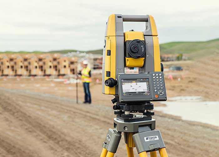
GIS Manager Kenny Ratliff, Oldham County Water District, collects utility data. (Photo: Eos Positioning)
Across North America, the use of high-accuracy GNSS technology has proliferated among water and wastewater service providers. Water utilities are saving time, cutting operational expenses, and definitively improving the accuracy of their asset management systems by capturing survey-grade location data.
Oldham County Water District serves more than 8,300 residences with 369 miles of pipeline in rural Kentucky. In 2001, the utility digitized its assets for the first time. In 2016, they decided it was time to improve the assets’ accuracy. GIS Manager Kenny Ratliff deployed ArcGIS Collector, iPad 2 mobile devices, and the Arrow Gold GNSS receiver by Eos Positioning Systems. As a result, OCWD was able to more quickly arrive exactly at the location where meters were to be replaced. With the savings of time, labor and fuel, OCWD cut the cost of installing each water meter by half, from $212 to $111.
Other water utilities are using GNSS technology to improve the office-to-field workflow, accelerate deployment of new systems, and map buried pipelines.
Offshore construction company Sulmara Subsea has exclusively used Hexagon | VERIPOS solutions since inception to achieve precise, redundant and reliable vessel positioning for a variety of marine construction projects. Projects involving the precise positioning of offshore vessels and subsea assets and vehicles such as ROVs and trenchers are vital to success — even slight errors or loss of connection in surface navigation can lead to problems and down time that can cost millions.
“Sulmara has set out to be an industry leader in innovation and technology from the start. Key to the success of any project is the ability to achieve accurate and reliable global positioning,” said Cory Goodyear, Sulmara’s Americas business unit director. “The support from Veripos to provide not only a cost-effective but reliable service is vital to our operations.
“2020 has seen an unprecedented decline in the oil and gas market, and a growing demand for renewable energy,” Goodyear said. “This has created an even larger demand for lower costs and increased reliability in our services. As a new-start survey company with a goal of establishing itself as a serious competitor, positioning services supported by Veripos was the obvious choice.”
Veripos offers customers several marine receiver options for hydrographic/offshore surveying, dredging, offshore construction, seismic exploration and dynamic positioning. The LD8 ruggedized compact dual-antenna, multi-constellation receiver is best for short-term projects or where space is limited. The larger LD900 can receive Veripos services through a multi-channel L-band demodulator. The multi-constellation receiver is configurable to allow GNSS heading and inertial positioning. It has an intuitive color display for configuration and monitoring. A kit allows the receiver to be installed within vessel equipment racks.
Over the years, contractors involved in underwater excavation projects — dredging, pond/lake expansions, creation of boat landings, waterfront cleanups, etc. — have become some of the most ardent supporters of GNSS-based solutions. They’ve found that the ability to “see” beneath the surface with their machines has proven invaluable in improving efficiency and minimizing the risk of over/under cutting.
The Minnesota Department of Natural Resources (DNR) led the effort to remediate a section of the St. Louis River on Duluth’s waterfront. Midwest Amphibious Equipment (MAE) tackled the huge restoration project, equipping two of its amphibious excavators with Topcon HiPer VR, an FC-5000 field controller and an X-53i system.
MAE began digging out vast amounts of wood waste that had rested at the bottom of the river for more than a century, when sawmills lined the waterfront. By removing the wood waste and building a small island in the Grassy Point area, the DNR hopes to restore the damaged habitat.
The murky water required a precise method of measuring the cuts as debris was removed. “The Topcon solution lets my guys know exactly where the bucket is in relation to the plan provided by the engineers,” said MAE CEO Steve Gilbertson. “There is no guesswork; it is dead-on every time, with tolerances to 1/10 of a foot — far closer than we need it to be.”
Topcon’s SiteLink 3D provides a point-to-point communications solution. “With the click of a button I can do everything from verifying a machine’s position to sending the as-built back to the office to looking at their screen to answer a question the operator might have about the project itself,” Gilbertson said. “We’ve only scratched the surface of what can be done with SiteLink, but it’s still proving a really nice addition to our operation.”
Less than halfway into the project, MAE had removed more than 100,000 cubic yards of material.
A roundup of recent products in the GNSS and inertial positioning industry from the November 2020 issue of GPS World magazine.
OEM
GNSS receiver
Sub-decimeter accuracy without additional service subscription
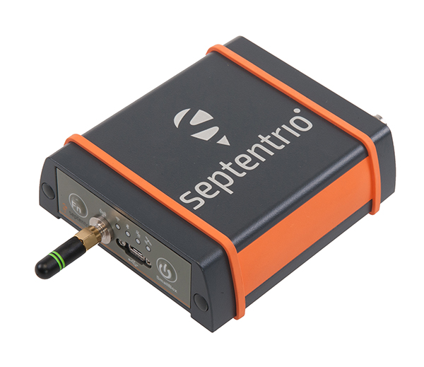
The AsteRs-m2-Sx. (Photo: Septentrio)
The SECORX-S product line, which first offered GNSS OEM boards, now also includes a compact mosaic-Sx module and ruggedized receiver in an IP68 chassis, the AsteRx SB Sx. The multi-constellation multi-frequency SECORX-S receivers deliver sub-decimeter positioning without the need for additional correction service subscription or maintenance. The PPP-RTK correction service is integrated directly into Septentrio’s core GNSS technology. The addition of modules and boxed receivers to the SECORX-S line providesz accurate positioning to applications such as precision agriculture, UAVs, robotics and construction.
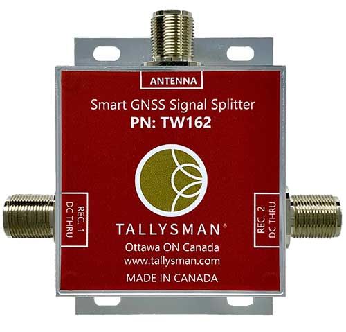
Smart Power GNSS signal splitters improve GNSS service reliability and minimize service interruptions. The professional-grade splitters — TW162 (one antenna/two receivers) and TW164 (one antenna/four receivers) — offer system redundancy and fail-over capability. The splitters are designed to improve GNSS service reliability and reduce signal reception failures. Both splitters offer system redundancy and fail-over capability. They support GPS/QZSS-L1/L2/L5, QZSS-L6, GLONASS-G1/G2/G3, Galileo-E1/E5a/E5b/E6, BeiDou-B1/B2/B2a/B3 and L-band correction services.
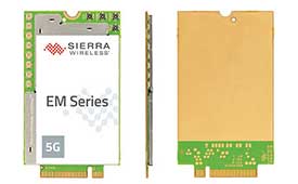
The EM919x 5G NR Sub-6 GHz and mmWave embedded modules include an integrated GNSS receiver. Based on the industry-standard M.2 form factor, the modules will enable original equipment manufacturers (OEMs) to securely deploy 5G connectivity worldwide at the highest possible speeds with ultra-low latency for routers and gateways. The modules support mmWave, sub-6 GHz and LTE, as defined by the 3GPP Release 15 standard. Applications include private networks, enterprise networking, edge processing, live streaming, video security, e-gaming, smart factories, robotics, drones, virtual reality, machine learning, and new Industrial IoT applications.
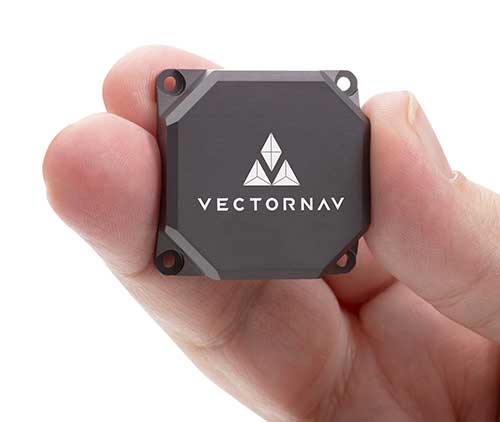
Tactical Embedded series of GNSS/IMUs. (Photo: VectorNav)
The Tactical Embedded series of GNSS/IMUs feature a tactical-grade inertial measurement unit (IMU) and a multi-band GNSS receiver. The line delivers milliradian attitude accuracy and centimeter-level positioning capability in a miniature 15-gram package. The small size enables cost reductions for a range of autonomous pointing and geo-referencing applications such as gimballed intelligence, surveillance and reconnaissance (ISR); satellite communication systems; lidar mapping; and photogrammetry. The line supports external SAASM GPS for defense applications in ISR, electronic warfare, munitions and UAV navigation. The line includes the VN-110E IMU/AHRS, the VN-210E GNSS-aided inertial navigation system (INS), and the VN-310E dual-antenna GNSS/INS.
VectorNav Technologies, vectornav.com
GNSS/INS Sensor
Designed for dynamic environments
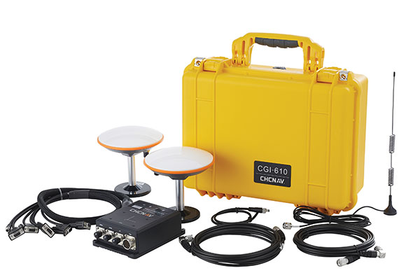
Photo: CHCNAV
The CGI-610 GNSS/INS high-precision dual-antenna receiver offers reliable and accurate navigation and positioning for demanding land, marine and aerial applications. The tight fusion of the latest GNSS technology with an industrial-grade MEMS IMU is powered by CHCNAV’s algorithms to deliver accurate hybrid position, attitude and velocity data, even in complex and obstructed environments where GNSS outages can occur. The CGI-610 supports data output up to 100 Hz to meet the requirements of highly dynamic applications such as airplane, train and automobile. An optional external odometer sensor for ground vehicles can provide an additional measurement of displacement and speed, which is fused with the GNSS/INS navigation solution.
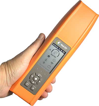
Bad Elf Flex is a scalable-accuracy GNSS receiver with a daily option to choose between L-band and real-time kinematic (RTK). In standard configuration, it achieves 30-60 cm accuracy in real time for GIS use. Consuming a Bad Elf Flex Token unlocks a full RTK workflow for a 24-hour period to deliver 1-cm horizontal accuracy. Bad Elf Flex stores the tokens directly on the receiver, making them available for use anytime. Customers requiring high accuracy at all times can purchase the Bad Elf Flex Extreme bundle, with RTK capabilities permanently unlocked, for a one-time upgrade fee.
The R550 data collector features an industrial-level design and new hardware platform to ensure efficiency and productivity in the field. The IP67 dust-and-waterproof rating protects the R550 from most harsh environments. Equipping it with a 7,000 mA Li-ion battery allows more than 14 hours of continuous operation, while fast-charging technology means four hours for a full charge. The 5-inch-wide sunlight-readable, high-resolution screen provides a smooth experience for any operation. The integrated autofocusing camera helps enhance job documentation by taking photos on site and sharing job information with colleagues. Survey Master field software available on the R550 controller ensures efficient surveys in the field, including topographic surveys, stakeouts, coordinate geometry (COGO) and more. Powered by the Android 8.1 operating system and designed with 4G RAM, 64GB ROM and 4G/BT/Wi-Fi on board, users can run other third-party apps based on their specific requirements.
The Trimble AP+ Air OEM solution provides direct georeferencing of airborne sensor data and enables users to accurately and efficiently produce maps and 3D models without the use of ground control points. It is designed for manned platforms, yet small enough for use on UAVs. It is also compatible with airborne remote sensors, including photogrammetric cameras, lidar, hyper- and multi-spectral cameras, and synthetic aperture radar. The Trimble AP+ Air features dual embedded survey-grade GNSS chipsets, an onboard inertial measurement unit (IMU), an external IMU, and the new Applanix IN-Fusion+ GNSS-aided inertial firmware. It is configurable to support the direct georeferencing accuracy demands of low-flying UAVs and high-altitude manned platforms. Trimble AP+ Air is supported by Applanix POSPac MMS post-processing software with CenterPoint RTX post-processing for centimeter-level positioning anywhere in the world without the need for base stations.
American-made drone aimed at government agencies and military
Photo: Teal
The Teal Golden Eagle drone is designed for short-range surveillance and reconnaissance missions. It features a FLIR Handron dual-camera sensor on a two-axis stabilizer, giving it color vision at 4K 60 fps and thermal vision for extended operations. The payload is hot-swappable. It has a flight time of up to 50 minutes and can fly at speeds of 50 mph with a range of 2 miles. It is able to fly in wind speeds of up to 30 mph and can operate between –32° and 110° Fahrenheit. Forward-facing obstacle avoidance and rear-facing visual-inertial odometry estimates location without the need for GPS. The platform has received approval from the Department of Defense.
A new line of AccuAuto triple-band antennas are designed to provide strong clean code and phase signals to enable high-precision real-time kinematic (RTK) and precise point positioning (PPP) navigation. Model TWA928 supports GPS/QZSS-L1/L2/L5, GLONASS-G1/G2/G3, Galileo-E1/E5a/E5b, BeiDou-B1/B2/B2a and NavIC-L5 signals and frequency bands (the TWA928L includes support for L-band correction services). The AccuAuto line features patented Accutenna technology multi-constellation and multi-frequency antenna elements as well as an integrated ground plane, a radome and an underside cover that provides mist and condensation protection. A deep pre-filter minimizes out-of-band noise and maximizes in-band reception. All AccuAuto components are certified and designed to perform under challenging environmental conditions, such as extreme temperatures (–40° C to +125° C), shock and vibration.
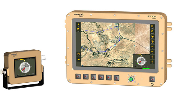
The CheetahNAV provides situational awareness for harsh environments and battlefield conditions, providing the crew of a light military vehicle with highly accurate position information through an advanced inertial measurement system (IMS) comprising several aids, including a gyro-compensated compass and an advanced Kalman-filter-based algorithm. The system provides dead-reckoning horizontal position accuracy of 0.2% of distance traveled in a GNSS-denied situation — accuracy of 200 meters over 100 kilometers. It can integrate with inertial navigation systems (INS). Combined with GNSS and compass information, the system enables dead-reckoning and accurate positioning of the vehicle in tactical situations. The tactical-grade integral inertial measurement unit (IMU) ensures jam-free operation.
Spot, the robotic dog from Boston Dynamics, is equipped with the Trimble SPS986 smart antenna to collect data. (Photo: Trimble)
Trimble and Boston Dynamics plan to integrate a variety of data-collection technologies with the Spot (robot dog) platform for construction and other site applications.
The jointly developed solution will combine the Spot robot’s autonomous mobility with Trimble’s data-collection sensors and field control software to enable automation of repetitive tasks such as site scans, surveying and progress monitoring, while taking advantage of the robot’s unique capabilities to navigate dynamic and potentially unsafe environments.
The relationship gives Trimble exclusive rights sell and support the Spot robot with integrated scanning, total station and GNSS technologies for the construction market.
The turnkey solution will streamline operation of the robot and provide quality control for missions, enabling construction project managers to easily get a clear picture of jobsite progress on an ongoing basis. Trimble technologies integrated with the robot will enable accurate, scalable and rapid data acquisition, while Trimble’s construction collaboration platforms provide a continuous flow of information between field and office.
Mortenson, a Minneapolis builder, developer and engineering services provider, is one of the first customers to leverage the new technology combination. To eliminate jobsite waste and increase efficiency, the Mortenson team has been piloting Spot robots with the Trimble SPS986 GNSS solutions to autonomously navigate challenging exterior construction environments such as solar farms, continuously documenting site conditions.
An automated and repeatable approach to field-data capture can provide Mortenson with real-time awareness of project status, helping to accelerate project delivery. Through Trimble’s Early Experience Program, contractors such as Mortenson have advanced access to this technology for the purposes of evaluating its suitability in actual construction projects.
The Trimble SPS986 smart antenna. (Trimble: photo)
“Robots will play a crucial role in automated construction workflows and can augment the human workforce by handling dirty, dull and dangerous tasks,” said Martin Holmgren, general manager, Building Field Solutions at Trimble. “Our experience with early adopters like Mortenson gave us visibility into the transformative potential of an integrated solution that seamlessly marries a world-class robot with construction-specific sensors and workflows. We’re excited about this alliance and the potential to bring unprecedented improvements in safety, quality and productivity to our construction customers.”
“We believe the combination of Trimble’s experience and industry leadership in construction technologies and Boston Dynamics’ Spot can transform the way the industry operates,” said Michael Perry, vice president of business development at Boston Dynamics. “The integrated solution will enable any jobsite leader to deploy Spot and Trimble technologies to get an accurate view of construction progress through real-time data collection. With a more comprehensive view of site activity, project managers can take proactive measures to ensure on-time, on-budget and safer project delivery.”
The integrated solution is expected to be available by the second quarter of 2021 through Boston Dynamics, Trimble and select BuildingPoint and SITECH distribution partners in the U.S., Canada, the United Kingdom, the European Union, Australia, New Zealand and Japan.
Through Trimble’s Early Experience Program, select customers will have the opportunity to preview development of the solution in advance of general availability.
The full GNSS User Technology Report 2020 is available for download. (Cover: GSA)
News from the European GNSS Agency
The European GNSS Agency (GSA) has released its latest GNSS User Technology Report, providing a comprehensive analysis of GNSS trends and developments.
With four GNSS available and more than 100 satellites in operation broadcasting multiple frequencies, the GNSS industry is shifting towards the wide adoption of multifrequency receivers across market segments to meet the diverging user needs of emerging applications.
The report includes contributions from leading GNSS receiver, chipset manufacturers and service providers, and serves as a valuable tool to support planning and decision-making with regards to developing, purchasing and using GNSS technology.
Published biennially since 2016, the User Technology Report has become a point of reference for the GNSS industry, research and policy-makers.
Rapid Evolution
‘’The GNSS industry is evolving at a rapid pace and is shaped by the dynamics of emerging applications and user needs as well as the upgrade of existing and new GNSS and Satellite Based Augmentation Systems (SBAS),” said Rodrigo da Costa, GSA executive director. “The industry has understood the potential of Galileo’s unique features.”
The third edition of the report begins with a chapter devoted to technology trends common to all segments: receiver design, position processing and signal processing. It also discusses protection measures against GNSS jamming and spoofing, such as authentication, including what 5G and other technologies and sensors can do, in combination with GNSS.
With multi-constellation now being the norm, the industry is moving towards the wide adoption of multi-frequency receivers even for usually power- and cost-constrained consumer solutions. The Galileo E5 is becoming the preferred frequency with about 20% of all receiver models in the market already using it.
The report is built around four macro segments defined on the basis of commonalities from a technology point of view:
high volume
safety- and liability-critical
high-accuracy
timing devices and solutions (a new-entry in this edition)
Each chapter starts with the macrosegment characteristics and receiver capabilities, depicts the industry landscape and typical receiver form factor, it then delves into the key current and future drivers and trends, and finishes with the added value of the EGNSS, Galileo and EGNOS, for the macrosegment at stake.
Space Data for Europe
This year editor’s special “Space Data for Europe” sheds light on the role that Copernicus and Galileo play within the European Space Programme in the data management and use, now and in the future. It also provides a vision of major transformations underway within our society and our economy and the benefits expected from this digital transformation, paving the way towards the European Data Strategy and Green Deal.
“Today, Galileo and EGNOS already provide increased capabilities which are being used across a broad range of applications, and are already igniting the next generation of location-based applications. In the future, new services — the Galileo High Accuracy Service (HAS), Galileo Open Service Navigation Message Authentication (OS-NMA) and Commercial Augmentation Service (CAS) — will raise the accuracy and reliability bar even higher, and dramatically enhance positioning, navigation and timing solutions for businesses and citizens.
By bringing insight and understanding into the evolutions of GNSS technology, we are creating opportunities for innovation,” concluded da Costa.
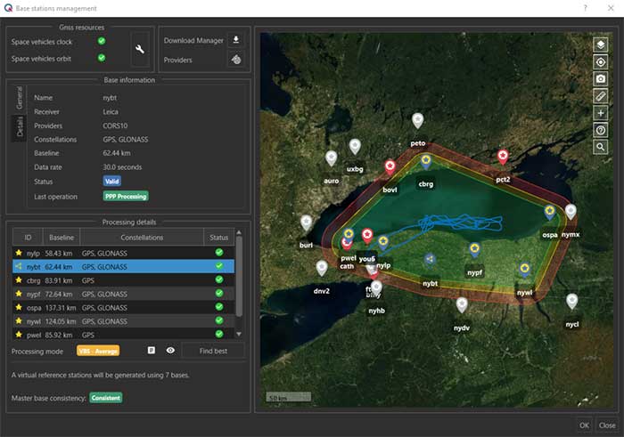
The virtual base station feature in SBG’s Qinertia computes a virtual network around a project in which position accuracy is maximized, homogeneous and robust, the company said. (Photo: SBG Systems)
SBG Systems has released a virtual base station (VBS) feature in Qinertia, its in-house GNSS and inertial navigation system (INS) post-processing software. According to the company, trajectory and orientation are greatly improved by processing inertial data and raw GNSS observables in forward and backward directions.
The VBS computes a virtual network around a project in which position accuracy is maximized, homogeneous and robust like a PPK short baseline, SBG said. Once surveyors collect data, Qinertia chooses the most relevant reference stations, builds a virtual network and brings the project to the centimetric accuracy with no jump on accuracy nor convergence effects, even in urban areas.
According to SBG, it has worked to offer a VBS which takes the most out of any GNSS receivers from different brands and models — with different configurations or constellations — and even with different coordinate systems. Qinertia automatically adjusts the VBS network to compensate for any base station position inaccuracy and provides full quality control indicators to assess the expected accuracy and reliability, the company added. Qinertia VBS technology can mix users base stations with permanent network base stations to improve accuracy in remote locations.
Finally, Qinertia automatically selects the best positioning technology that applies to a user’s project, whether it is a single base station mode, the virtual base stations mode or a precise point positioning computation. Despite this, users can still take control and make adjustments — like — while Qinertia automatically re-checks and re-computes all parameters simultaneously to validate the accuracy and consistency.
A roundup of recent products in the GNSS and inertial positioning industry from the October 2020 issue of GPS World magazine.
OEM
GNSS antennas
Active and passive
Photo: 2J Antennas
A new range of high-precision GNSS antennas is designed for superior accuracy and reliability, with both active external antennas and passive internal ceramic antennas. The antennas provide precision, high bandwidth, and an advanced signal design for GPS, GLONASS, BeiDou, Galileo, IRNSS and SBAS navigation. They are designed for demanding GPS applications that require centimeter-level accuracy by combining precise point positioning (PPP) of L1 and L2 or by combining L1 and L5 bands with real-time kinematic (RTK) satellite navigation. Applications include aviation safety, UAVs, transportation, autonomous vehicles, agriculture and land and hydrographic surveys.
The HC976 housed and HC976E embedded helical antennas are light and compact, suitable for applications ranging from autonomous navigation to GNSS timing. Both models support GPS/QZSS-L1/L2/L6, GLONASS-G1/G2, Galileo-E1/E6, and BeiDou-B1/B3 frequency bands as well as regional augmentation systems and high-precision L-band correction services. The HC976 and HC976E support QZSS-L6, Galileo-E6 and BeiDou-B3. The HC976 is 44 x 62 millimeters and weighs 42 grams. It features a precision-tuned helical element that provides an excellent axial ratio and operates without the requirement of a ground plane, making it suitable for a wide variety of high-precision applications.
The mosaic-T GPS/GNSS receiver module is built for resilient and precise time and frequency synchronization under challenging conditions. Its multi-frequency, multi-constellation GNSS technology with AIM+ Advanced Interference Mitigation algorithms allows mosaic-T to achieve maximal availability even in the presence of GNSS jamming or spoofing. The compact surface-mount module is designed for automated assembly and high-volume production. Mosaic-T delivers timing and has additional inputs for an external high-accuracy clock.
The HGuide n380 inertial navigation system (INS) communicates an object’s position, orientation and velocity when GNSS signals are unavailable. It is built to withstand harsh environments in the air, on land or at sea. It is designed to meet the need for a small, high-performance INS for 3D mapping, surveying and other applications where space is at a premium. It is composed of Honeywell’s HGuide i300 inertial measurement unit (IMU), a GNSS receiver and Honeywell’s proprietary sensor-fusion software, which is based on the algorithms used for navigation on millions of aircraft every day.
The LC29D eMobility module is a sub-meter-level GNSS module that integrates dead-reckoning and multi-band (L1/L5) real-time kinematic (RTK) algorithm technologies with fast convergence times and reliable performance. The module supports dual-band GNSS raw data output and integrates a 6-axis IMU sensor to deliver high-accuracy positioning performance in seconds. Based on the Broadcom BCM47758 GNSS chip, the LC29D can concurrently receive signals from up to six constellations (GPS, GLONASS, Galileo, IRNSS, BeiDou and QZSS), which maximizes the availability of sub-meter level accuracy. It offers a position update rate of up to 30 Hz (fusion output), enabling dynamic applications like shared emobility, delivery robots and precision agriculture to receive position information with lower latency.
The AlphaUni 300/900/1300 lidar series provides light, versatile long-range laser scanner systems for the high-end market. The series provides optimized data sets powered by advanced GNSS/inertial navigation system (INS) sensors and long-range Riegl scanners. AlphaUni’s design adapts to a variety of applications and can be installed on a variety of platforms, including multi-rotor UAV, fixed-wing vertical-takeoff-and-landing (VTOL) UAV, vehicles, rail trolleys, backpacks, boats and more.
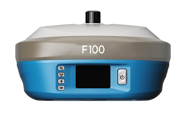
The F100 GNSS receiver, an upgrade to the F90, is designed to meet surveyors’ demands for high field performance, flexibility and cost-effectiveness. It tracks multiple constellations (GPS, GLONASS, Galileo, BeiDou) and can maximize the acquisition and tracking process with all-in-view GNSS frequencies. The 1.45-inch color LCD display is a multi-touch capacitive screen. The F100 has 32GB of internal memory. Its integrated second-generation web user interface control is compatible with all devices and browsers.
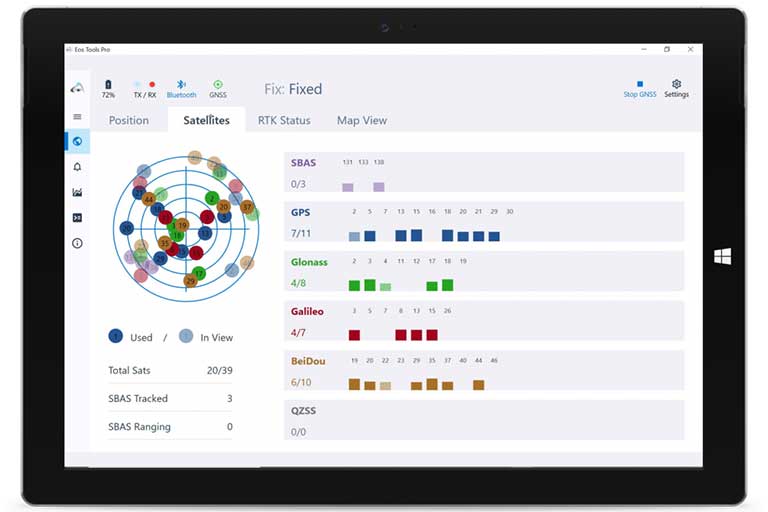
Eos Tools Pro for Windows 10 implements powerful new features that enable users to exploit all four global GNSS constellations and a state-of-the-art NTRIP client to access real-time kinematic (RTK) bases and RTK networks all over the world via NTRIP, Direct IP and wireless radios. It provides the latest support for Windows Geolocation and other features by Microsoft to allow customers to use high-accuracy locations directly in their apps, such as RTK network/RTK base connectivity, support for all new Beidou and Galileo satellites, and SafeRTK functionality for areas with marginal cellular coverage. Features for app developers are also available.
The BB4 UAV high-end multi-rotor drone is optimized for the AlphaUni 300/900/1300 lidar series. Its modular design simplifies deployment in just a few minutes. Its 7-kg payload breaks the capacity barrier, and its more than 45 minutes of flight time increases the airborne lidar survey ability. The redundant CHCNAV and DJI inertial measurement unit (IMU) and GNSS unit provide reliable centimeter real-time kinematic (RTK) positioning, meeting the demand for high accuracy in the geospatial and mapping industries.
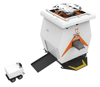
The ADNET autonomous delivery network is a technical solution to transport medical samples and quarantine materials in cities. It uses an RA3 drone, unmanned vehicle RG1 and RH1 hub station to deliver medical supplies without relying on manpower, alleviating time spent in traffic and the cost of traditional delivery. Supplies retrieved by the RG1 vehicle are delivered to the RH1 hub for sorting and redirecting, while the drone transfers the supplies between hubs. The RG1 then delivers goods on the receiving end. The system was demonstrated during China’s COVID-19 epidemic prevention and control period, reducing contact between samples and personnel.
The VECTOR-400 is a compact autopilot designed specifically for unmanned aerial vehicles. It features a robust enclosure and a military-grade connector for harsh environments (MIL-STD 810 and MIL-STD 461). Features enable sea-skimming (extremely low-level flight) and the capability to navigate without GNSS. The VECTOR-400 is able to continue a mission in case of individual sensor failure and when subject to jamming, maintaining accurate estimations of attitude and position. Advanced algorithms provide stall prevention and the ability to carry out an efficient gliding maneuver in case of engine failure. Its air data attitude and heading reference system and inertial navigation system provide high-precision attitude information and reliable navigation under demanding circumstances.
The F700 DroneHunter UAS is a radar-based autonomous interceptor drone for tracking and stopping dangerous drones. Its flexible undercarriage offers interchangeable counter measures for single, multiple or swarm-based threats, while its lightweight carbon-fiber frame enables quick speed and response. The F700 can carry multiple types of anti-drone countermeasures and deploy them in real time, based on which dynamic threat is detected miles beyond the protected area. The pogo pins and payload snaps of the undercarriage are integrated with artificial intelligence for firing and flight software.
Drones equipped with cost-intensive cameras and sensors need protection in the event of a flight-system failure. A parachute system for the DJI M210 drone is now available. Both commercial and emergency response operations are using the M210; its design and flexibility allow for a variety of industry-specific applications. The DRS-M210 parachute system is designed to ensure high pendulum and wind stability, allowing a damaged drone to land safely with minimal impact.
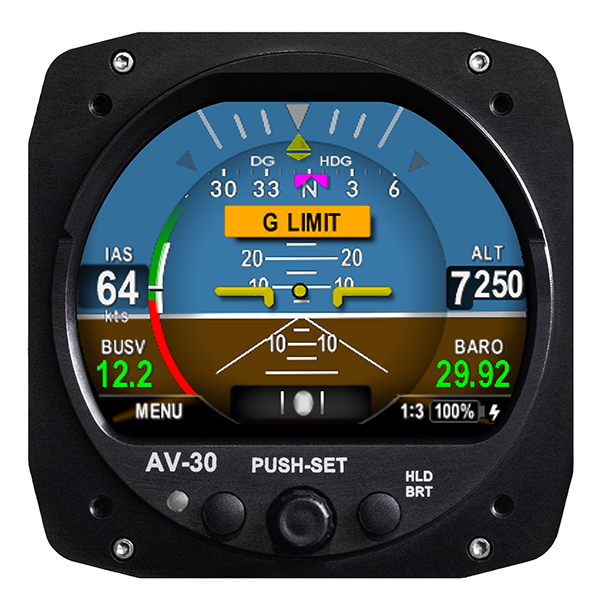
Altitude indicator (AI) or directional gyro (DG) replacement
Photo: uAvionix
The AV-30-C aircraft panel display adds a suite of in-flight information for pilots, including GPS navigational data, a probeless angle of attack indicator, baro-corrected altitude, indicated/vertical/true airspeed, non-slaved heading, bus voltage and G load. It is designed to fit into any aircraft with a 3 1/8-inch round instrument slot without cutting or modifying the panel. It is authorized for FAR Part 23 Class 1 and Class 2 aircraft listed on the AV-30-C Approved Model List (AML), containing 635 aircraft models including Cessna, Piper, Beechcraft, American Champion, Maule, Boeing, Swift, Mooney, Aviat and others.
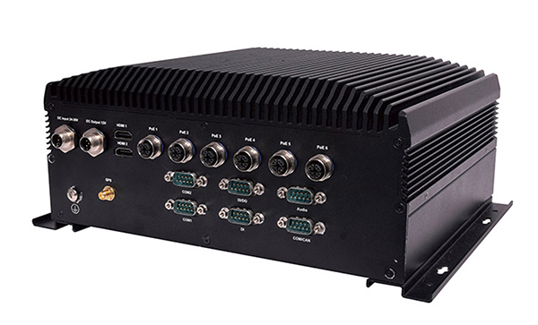
The R3S series of rugged, EN-50155-certified fanless vehicle/rail computers is equipped with a u-blox NEO-M8N module, which receives GPS, Galileo, GLONASS and BeiDou with the default set for GPS + GLONASS dual band. The series offers power-efficient performance for consolidating in-vehicle workloads such as video surveillance, control/monitoring, passenger information and Wi-Fi hotspot sharing. For edge-to-cloud connectivity, R3S uses its internal GPS/GLONASS chipsets for GPS tracking and has two M.2 slots with up to 4x SIM card readers for failover LTE connection. To ensure proper operations in moving vehicles, the series is certified with EN50155, EN50121-3-2, EN50121-4, EN50125-3, EN45545 and E13 standards and has passed MIL-STD-810G shock and vibration resistance certifications. The series can operate under a wide temperature range and offers excellent reliability in harsh railway settings. It has one external removable 2.5-inch HDD/SSD drive bay for recorded footage storage. For consolidating in-vehicle workloads such as in-vehicle control/monitoring and passenger information, the R3S features a variety of I/O support, including 2x HDMI, DI/DO, 3x COM/CAN BUS and 4xUSB ports.
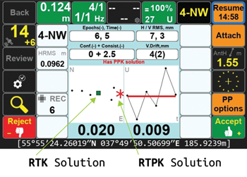
Javad GNSS introduced a new solution, Real-Time Post-processed Kinematics (RTPK), at Intergeo Digital 2020.
With the new option, the Javad Triumph-LS combines the strengths of RTK and PPK into a system that can post-process RTK data and verify its results in parallel and real time.
If RTK fails, RTPK is available in a fraction of a second, the company said.
Screenshot: Javad GNSS
“The RTPK feature is about as simple as any feature can get,” said Darren Clemons, PLS. “When you are on a point and stop the session, the LS automatically starts downloading the data for the time period matching that session from your base (or RTN) and then internally in the LS (no internet connection required) runs the post processing and gives you the PPK solution right there on your point in real time. […] It is a very nice and ingenious feature and, for us anyway, is a great check on our RTK results.”
The new the GT series of total stations are part of a full workflow solution, including a new field computer, a full-version update to Topcon field and office software and GNSS receivers. The system is designed to work in sync for improved performance and better data handling with built-in, field-to-office connectivity.
The speed, tracking and accuracy of the GT series, combined with the intuitive software system, creates a flexible solution capable of satisfying the technology needs of surveyors and contractors performing survey, layout or machine guidance projects, Topcon said.
“The new total stations perform at a faster 10-Hz positioning update rate,” said Ray Kerwin, director of global product planning. “Combining the GT series with the new field computer and software enhancements, this tracking improvement makes layout easier and guidance more fluid, within an intuitive map view. More layout and survey points can be collected in less time.”
“Surveyors, contractors, as well as heavy machinery automation operators and other construction professionals can benefit from the time-savings and accuracy the series provides,” Kerwin said.
Advanced UltraTrac prism tracking combines optical sensing with a new ultrasonic motor control algorithm designed to maintain superior prism lock.
“Tracking fast-moving targets and maintaining prism lock is now easier on challenging job sites as well as in machine guidance applications. If you’re performing a machine control project where the prism is vibrating on the end of the blade, for instance, the GT will lock onto the prism better and provide smoother machine guidance,” Kerwin said.
Magnet software improves field-based quality reporting and data handling for larger files, graphical processing, and 3D models. Magnet Field features more visual- and map-based workflows in addition to menu-driven functionality popular with power users.
An optional upgrade incorporating hybrid positioning technology helps advanced users get instant location updates via GNSS receivers so positioning data points can be captured, even with the loss of line-of-sight from job site obstructions.
The complete GT series workflow solution — Magnet software, FC-6000 field computer, and HiPer Series GNSS receivers — combine for easy-to-use digital processes designed to help surveyors and contractors increase precision, reduce rework and improve quality control.
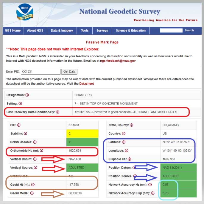
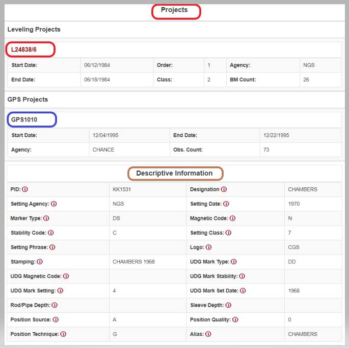
NGS has developed a new beta tool for obtaining geodetic information about a passive mark in their database. This column will highlight some features (available as of Oct. 5, 2020) that may be of interest to GNSS users. It provides all of the information about a station in a more user-friendly format. The box titled “Passive Mark Lookup Tool” is an example of the webtool. The tool provides a lot of information so I have separated the output of the tool into several boxes titled “Passive Mark Lookup Tool — A through D.”
I will highlight several attributes that I believe will be very useful to users, especially users of leveling-derived and GNSS-derived orthometric heights. I’ve highlighted several attributes in the box titled “Passive Mark Lookup Tool — A” that are important to users such as published coordinates, their datum and source, Geoid18 value, GNSS Useable, and the date of last recovery. All of these values are available on a NGS datasheet but, in my opinion, this provides the information in a more user-friendly format.
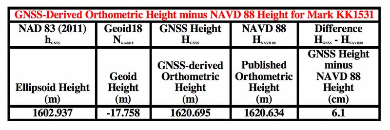
One calculation that the user can easily compute for marks that have been leveled to and occupied by GNSS equipment, is the difference between the published leveling-derived orthometric height and the computed GNSS-derived orthometric height. This may indicate that the mark has moved since the last time it was leveled to or that its height coordinate has been readjusted since the creation of the published geoid model.
The table below provides the calculation using the data from the box titled “Passive Mark Lookup Tool — A.” The calculation [HGNSS = hGNSS — NGeoid18; Difference = HGNSS — HNAVD 88] has been described in several of my previous columns (this one, for example).
Data: National Geodetic Survey
In this example, the difference between the GNSS-derived orthometric height and the Published NAVD 88 height is 6.1 cm. NGS is looking for comments on this beta webtool so if users would like this computation added to the tool, they should send a comment to NGS using the link provided on the site (This is a beta product. NGS is interested in your feedback concerning its function and usability as well as how users would like to interact with NGS datasheet information in the future. Email us at [email protected].) So, the user should ask the question, did the station move since the last time it was leveled?
Another attribute that would be nice to be part of this tool is which station was used to create the hybrid geoid model. As of Oct. 5, 2020, users have to go to the Geoid18 webpage to get the information. The Excel file and shapefiles provide whether the station was used to create the Geoid18 model. In the case of this example, KK1531, CHAMBERS, the mark was not used in the creation of Geoid18 so NGS felt that the station may have moved and/or the GPS on Bench Mark residual was large relative to its neighbors. See NGS’s technical report on Geoid18 for more information on the creation of Geoid18. The GPS on Bench Mark residual analysis was described in several of my previous columns (see “The differences between Geoid18 values and NAD 83, NAVD 88 values” and “NGS 2018 GPS on BMs program in support of NAPGD2022 — Part 6” for examples).
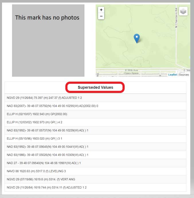
The webtool provides a map depicting the location of the station, photos (if available), and previously published, superceded values of the mark. See the box titled “Passive Mark Lookup Tool — B.”
In the example of Chambers, KK1531, no photos were available. It would be helpful if a user would provide photos to NGS when visiting this station. (Note: NGS has a webtool for users to submit recovery information about a mark as well as to provide current photos of the station.) The new Passive Mark webtool also provides information about the survey projects that the mark has been involved in such as leveling and GNSS projects.
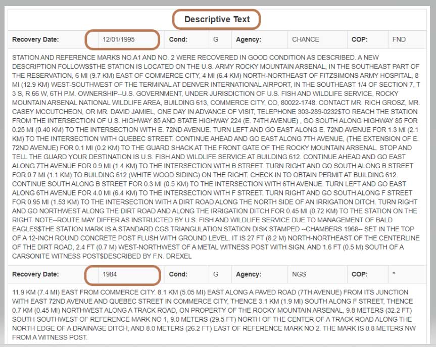
In this example, mark CHAMBERS was leveled to in a 1984 first-order, class 2 leveling project (Leveling Line number L24838/6) and, in 1995, the mark was part of a GNSS project (GNSS Project GPS1010). It also provides all the descriptive text and recovery information (See boxes titled “Passive Mark Lookup Tool – C” and “Passive Mark Lookup Tool – D”).
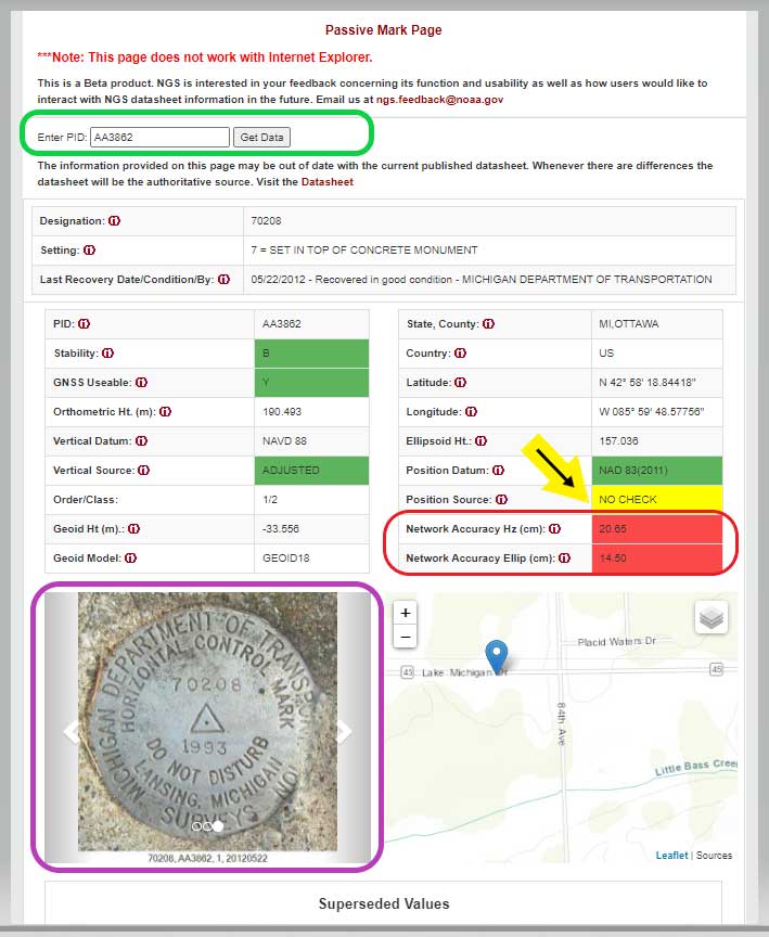
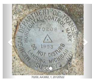
I want to highlight a few other attributes of this webtool. The station, PID AA3862, has an interesting attribute that users should take note of; that is, the NAD 83 (2011) position source is NO CHECK. See box titled “Passive Mark Page for PID AA3862.”
This means that the mark’s NAD 83 (2011) coordinates were determined without redundant observations. This is not a good survey practice but there are times that a project may contain check observations for some purpose or, more likely, the mark did contain other GNSS vector but they were rejected in the final adjustment. Either way, a good survey practice would be for users to verify the coordinates of these marks before using them.
Passive Mark Page for PID AA3862
Data: National Geodetic Survey
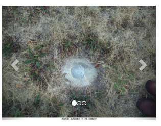
As previously mentioned, the tool provides the location of the station on a map and photos if they are available. This is a really nice feature for anyone searching for the mark. The map can be enlarged as well reduced by clicking on the box. See boxes titled “Passive Mark Page for PID AA3862” and “Photos of Mark PID AA3862.” The box titled “Photos of Mark PID AA3862” provides all three photos of mark PID AA3862.
Photos of Mark PID AA3862
Photo: National Geodetic SurveyPhoto: National Geodetic Survey
Photo: National Geodetic Survey
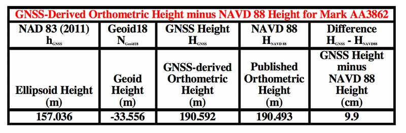
It should be noted, according to the Geoid18 GPS on BMs dataset that users can download, this station, AA3862, was not used in the creation of Geoid18. The table below provides the difference between the GNSS-derived orthometric height and the published NAVD 88 height.
In this example, the difference between the GNSS-derived orthometric height and the published NAVD 88 height is 9.9 cm. Also, the webtool provides the network accuracy values for the station. In this example, the horizontal network accuracy is 20.65 cm and the vertical network accuracy value is 14.50 cm (see highlighted values in box titled “Passive Mark Page for PID AA3862”). These are very large network accuracy values. This should be a flag to anyone that is using this station as control.
Data: National Geodetic Survey
As I previously mentioned, as a beta site, users should verify all information from the site. NGS is requesting feedback on this tool so they can improve it and make it an operational webtool. I encourage everyone to access the tool and check out a few of their favorite marks, and then send an email to NGS informing them of what you like, what you would like to change, and what you would like to see added to the tool.
NGS is releasing this tool as a beta product to get feedback from users. As NGS states in the heading of the tool, they are interested in your feedback concerning its function and usability as well as how users would like to interact with NGS datasheet information in the future. Email NGS at [email protected].
One last item that may be of interest to GNSS users is that NGS, working with the University Corporation for Atmospheric Research (UCAR), developed another online GNSS lesson (see box titled “New GNSS Lesson by NGS and UCAR”). These lessons are free but users must sign up to access the website and lesson.
An IMU-RTK GNSS receiver that fits in your hand and a fully integrated GNSS base station add a new scale to GNSS surveying applications.
CHC Navigation (CHCNAV) has announced the immediate availability of the i73 GNSS, a versatile pocket-sized IMU-RTK GNSS rover with an integrated inertial module and the iBase GNSS, a rugged base GNSS receiver.
The combination of the i73 GNSS and the iBase GNSS offers a productive and affordable solution for measuring and staking out points in any surveying, mapping or construction application.
“Surveyors and construction professionals are forced to carry heavy and cumbersome GNSS receivers in most situations, resulting in unnecessary fatigue and lower productivity,” said Hans Huang, product manager of CHC Navigation’s Survey and Engineering Division. “Taking this into account, we have developed our pocket-sized i73 GNSS, the lightest GNSS rover powered by the latest IMU-RTK technology, and much more. Our iBase GNSS station follows the same concept of an all-in-one solution, making the need for external radio modems and other bulky accessories obsolete.”
The i73 Pocket IMU-RTK GNSS: A new scale to GNSS
The i73 Pocket IMU-RTK GNSS. (Photo: CHCNAV)
Weighing only 730 grams yet with 15 hours of operating time, the i73 GNSS is one of the lightest and most rugged RTK GNSS receivers on the market.
Easy to carry and use, the i73 will not tire out field workers. It offers superior GNSS signal tracking enables surveys beyond the usual constraints. It features full 624-channel GNSS technology and connects seamlessly to RTK GNSS networks as well as to UHF GNSS station over its embedded UHF modem.
Automatic pole-tilt compensation. The i73 GNSS internal interference-free inertial module (IMU) allows automatic pole tilt compensation of up to 45 degrees. Projects are completed 30% faster and with increased efficiency and safety when measuring hard-to-reach points.
The iBASE GNSS: Redefining the concept of GNSS base station
The iBASE GNSS receiver. (Photo: CHCNAV)
The GNSS iBase is a fully integrated GNSS base station, specifically designed to meet 95% of surveyors’ needs when working in UHF GNSS base and rover mode. The performance of the iBase UHF base station compared to a conventional external UHF radio modem is virtually identical. But its unique design eliminates the need for a heavy external battery, bulky cables, an external radio, and a radio antenna. Its 5-watt radio module provides operational GNSS RTK coverage up to 8 km.