Advanced Navigation has expanded its Certus product line by introducing the Certus Mini series. This development marks a significant advancement in compact and high-performance navigation technology for field robots, autonomous vehicles and UAVs.
The Certus Mini series comes in three variants:
Certus Mini D: A dual-antenna inertial navigation system (INS)
Certus Mini N: A GNSS-aided INS
Certus Mini A: An attitude and heading reference system (AHRS)
These lightweight systems, weighing no more than 55 grams (1.9 oz.), offer impressive performance and cost-efficiency for their size.
The Certus Mini D utilizes dual-antenna GNSS for accurate heading, position, and velocity measurements. It operates on L1/L5 multi-constellation GNSS and offers enhanced interference immunity and position accuracy, particularly in challenging urban environments.
The Certus Mini series is designed to integrate into legacy systems and new builds. Its versatility makes it suitable for various applications, including surveying, agricultural robotics, open-pit mining and asset tracking.
Rx Network has launched TruePoint | REACH, an advanced, hardware-agnostic, cloud-based correction service designed to deliver centimeter-level location accuracy worldwide for various professional applications.
TruePoint | REACH offers precise centimeter-level positioning to enhance GNSS receivers’ performance in applications such as precision agriculture, machine control, mining, marine operations, UAV, GIS and more. The service is compatible with leading commercial off-the-shelf receivers using the RTCM 3.3 SSR and the 3GPP LPP SSR format. The company said key hardware partnerships are in the planning stages and will be announced soon.
TruePoint | REACH eliminates the need for users to set up their own base stations. Users can achieve centimeter-level accuracy by connecting receivers to the cloud while leveraging Rx Networks’ comprehensive global coverage.
Its correction engine is built to provide centimeter-level accuracy worldwide and can achieve sub-3cm precision in under 10 minutes. This makes it suitable for applications that require moderate initialization times for high-precision services.
A test version of TruePoint | REACH is available for those interested in assessing its capabilities. Users can sign up for a complimentary 30-day trial license through the Rx Networks website.
u-blox and Topcon Positioning Systems have formed a strategic partnership to develop a high-precision GNSS positioning service for the mass market.
The partnership was formed in response to the increasing demand for GNSS precise positioning across various applications. According to a recent EUSPA report, services enabled by GNSS devices are projected to generate approximately 80% of total GNSS revenues by 2033.
The comprehensive GNSS correction services will serve a wide range of applications requiring precise positioning, including automotive, industrial, robotics, construction, precision agriculture and mobility sectors. These services will integrate with u-blox’s current and future hardware products, as well as existing services such as PointPerfect.
The increasing prevalence of GNSS spoofing in commercial aviation poses significant safety concerns and highlights the need for robust alternative positioning, navigation and timing (A-PNT) sources. This form of electronic warfare, which uses fake signals to confuse aircraft navigation and safety systems, has become a growing issue for civilian flights worldwide.
Pilots told The Wall Street Journal that spoofing incidents have risen in recent months. According to analyses from SkAI Data Services and the Zurich University of Applied Sciences, the number of affected flights per day increased from a few dozen in February to more than 1,100 in August 2024.
The issue of spoofing has expanded beyond active conflict zones near Ukraine and the Middle East, and now affects hundreds of civilian pilots daily on a global scale. The modern cockpit’s heavy reliance on GPS technology means that falsified data can have far-reaching consequences, breaching multiple aircraft systems and causing disruptions that may last anywhere from a few minutes to an entire flight.
According to anonymized reports shared with government agencies and industry groups, pilots have experienced many alarming incidents, including sudden clock resets, false terrain warnings and unexpected flight path deviations. This surge in GNSS spoofing attacks highlights the vulnerability of critical navigation systems and raises significant concerns about aviation safety in an increasingly complex environment.
All jammed up The Wall Street Journal reported that in August 2024, a United Airlines flight from New Delhi to the New York area encountered a GPS spoofing incident that affected its navigation systems for the duration of the flight.
Initially, the flight seemed to adhere to the standard GPS route across Asia, mirroring the path taken by previous flights heading to Newark Liberty International Airport. The spoofing attack, originating in the Black Sea region south of Ukraine, caused the aircraft’s GPS coordinates to deviate progressively from its actual position throughout the remainder of the flight.
Even after the plane had left the affected area, its reported GPS location continued to show erratic behavior, occasionally making sudden jumps. This suggested that the navigation equipment was struggling to recalibrate accurately. While alternative navigation systems ensured the flight’s safe completion of its intended route, the compromised GPS data indicated that it had terminated in the Atlantic Ocean. In reality, the aircraft landed safely at its scheduled destination in Newark.
Keeping operations safe Aviation safety officials said spoofing has disrupted some flights but has not posed major safety risks. Pilots are trained to use A-PNT systems as backups. However, managing false GNSS signals and alerts risks dividing the operator’s attention if a more severe problem arises.
“If we lose an airplane because of workload issues because of these problems we’re encountering, compounded with an emergency, that is going to be a horrendous event,” said Ken Alexander, the Federal Aviation Administration’s chief scientist for satellite navigation, during a pilot union forum in Washington, D.C.
Airlines are collaborating with aircraft manufacturers, parts suppliers, and aviation safety authorities to devise immediate solutions and long-term strategies. For example, the International Air Transport Association (IATA) and the European Union Aviation Safety Agency (EASA) are openly discussing these challenges and holding workshops to share best practices. Safety bulletins have also been issued for operations where spoofing and jamming are known to have occurred.
Industry insiders told The Wall Street Journal that the development of new equipment standards to enhance civilian aircraft resilience against spoofing attacks is not expected to be finalized until 2025.
Navigating issues across sectors According to anonymized reports collected by OpsGroup, an aviation safety organization that includes pilots, dispatchers and other airline staff, various attacks have caused navigation issues across multiple sectors.
GNSS spoofing has disrupted operations in Europe but has not endangered flights, said Florian Guillermet, executive director of the European Union Aviation Safety Agency. Pilots had to divert to airports they did not intend to land at, and earlier this year, an airline temporarily halted operations at an Estonian airport that was not equipped with ground-based navigation as a backup for GNSS.
Boeing said manufacturers, carriers and regulators globally are contributing GPS expertise for solutions to ensure safety. Boeing and Airbus are working with airlines to help develop procedures to assist pilots, the companies said.
United and American said their pilots are equipped with several ways to navigate with precision, even with GPS interference. American said it has not experienced disruptions or significant safety concerns from GPS interference.
Insights from industry experts
During the 64th Civil GPS Service Interface Committee Meeting — hosted at ION GNSS+ 2024 from Sept. 16-17 — The presentation “Complementing GNSS for Resilient Performance Based Navigation” by Okuary Osechas Ph.D., and Gary A. McGraw, Ph.D., addressed the critical role of complementary positioning, navigation and timing (CPNT) technologies in aviation, particularly in light of increasing threats to GNSS.
The presentation highlights the impact of radio frequency interference (RFI) on aviation, including jamming and spoofing. These pose significant risks to aviation safety by reducing operational margins. The prevalence of these threats is increasing, necessitating alternative navigation solutions.
Performance-based navigation (PBN) is essential for modern aviation, enhancing efficiency and flexibility. However, it relies heavily on GNSS, making it vulnerable to disruptions, again highlighting the need for CPNT services.
Integrating CPNT sources ensures resilient navigation capabilities. This includes leveraging legacy navigation aids and modernized terrestrial systems. Various complementary technologies such as eDME, eLORAN, LDACS-NAV and LEO SATNAV are being assessed for their operational effectiveness, compatibility and potential to support aviation needs.
The researchers recommend the following to address these challenges:
Near-term solutions: Implementing eDME for backward compatibility. Medium-term strategies: Utilizing eLORAN for wide-area time distribution. Long-term goals: Developing LDACS-NAV to enhance spectrum efficiency and standardization. Collaborative efforts: The presentation calls for international cooperation in research and development to advance standards and infrastructure investments in complementary PNT technologies.
SiTime has launched the Endura Low Phase Noise Super-TCXO time synchronization and RF systems designed for high-performance applications requiring stability and low noise in challenging environments.
These devices operate within a frequency range of 10 to 220 MHz and offer frequency stability, with specifications as tight as ±0.1 ppm over a temperature range of -40°C to 105°C. Their phase noise performance can achieve -159 dBc/Hz at a 10 kHz offset for a 19.2 MHz carrier frequency and reach -172 dBc/Hz for broad base phase noise.
The Endura Super-TCXOs exhibit an acceleration sensitivity of 0.01 ppb/g and can withstand shocks up to 30,000g and vibrations up to 70g, making them suitable for demanding applications.
These Super-TCXOs are ideal for various applications, including time synchronization and RF systems, aerospace and defense networking, communication systems and positioning, navigation and timing (PNT) applications.
SiLC Technologies has received an investment from Honda to develop frequency-modulated continuous wave (FMCW) lidar solutions. This collaboration aims to advance artificial intelligence (AI)-based machine vision capabilities for autonomous vehicles and other mobility systems.
SiLC’s FMCW lidar technology offers long-range detection, precise measurements, interference resistance and enhanced object detection. It can detect objects at distances of a kilometer or more, offering accurate distance and velocity measurements while overcoming issues related to sunlight, reflectors and other lidar systems. Additionally, it can identify dark objects, such as tires, at long distances.
The investment from Honda supports the development of vision systems that are powerful, computationally efficient, compact, and scalable. These attributes are crucial for advancing autonomous transportation technologies that can enhance safety, reduce traffic congestion and minimize human error on the roads.
As a FMCW lidar developer, SiLC’s technology could play a role in advancing autonomous systems. The company’s Eyeonic Sensor and Vision System is an advanced lidar technology centered around the Eyeonic Vision Chip. This chip integrates multiple photonics functions, including an ultra-low linewidth laser, semiconductor optical amplifier, Germanium detectors and optical circuits on a silicon photonics chip. This compact design enables long-range detection of more than 2 km with sub-millimeter resolution, offering capabilities such as distance measurement, instantaneous velocity, and polarization intensity through FMCW lidar technology.
The ping200XR TSO has received TSO-C112e and TSO-C166b for transponder and ADS-B functionality — TSO-C188b for its internal pressure altimeter, and TSO-C145e for the integral aviation GPS.
It is a compact Mode S ADS-B transponder with an integrated GPS receiver, measuring 47 x 72 x 10mm and weighing just 52 grams. This device combines the functionality of a transponder and GPS into a single unit, making it suitable for airspace access and operations involving certified aircraft.
The ping200XR facilitates seamless integration into national and international airspace systems by enabling aircraft detection by secondary surveillance radar (SSR), traffic collision avoidance systems (TCAS), and ADS-B IN receivers. Additionally, it has received technical standard order (TSO) certification from the FAA, ensuring that it meets specific performance standards established by the aviation regulatory body.
The ping200XR can be used in high-altitude aircraft and balloons operating in Class A airspace and above. With the new TSO certifications, the device can now be utilized in regions that mandate such approvals, including Europe, the United Kingdom, Australia and New Zealand. This certification also makes the ping200XR TSO a viable option for aircraft pursuing type certification, such as electric vertical take-off and landing (eVTOL) and Advanced Air Mobility (AAM) platforms. The certified version is scheduled to become available for purchase starting in September 2024.
ANELLO Photonics and Beamagine have entered a strategic partnership to enhance vehicle localization for automotive OEMs, HD mapping projects, municipalities and agricultural applications in GPS-challenged environments. This collaboration combines ANELLO’s photonic gyroscopes and navigation solutions with Beamagine’s lidar and vision technology to create a robust sensor fusion solution.
The partnership will integrate Beamagine‘s L3CAM lidar camera, which features sensor fusion capabilities and embedded AI perception processing, with ANELLO’s GNSS/INS system, which features optical gyroscope technology.
The system aims to significantly improve vehicle localization and offer reliable navigation and positioning in challenging conditions, including urban canyons, tunnels and other GPS-denied environments. It is designed for easy integration into existing autonomous vehicle platforms to offer enhanced localization capabilities for safer autonomous driving.
For automotive OEMs, it offers improved accuracy and reliability for autonomous driving applications. HD mapping projects and municipalities can benefit from precision in infrastructure maintenance and mapping tasks. For precision agriculture, users can gain more accurate positioning capabilities in orchards and other areas with limited GPS availability, improving various farming operations.
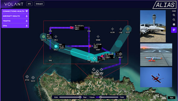
uAvionix has integrated its FlightLine surveillance services with Volant Autonomy’s integrated traffic management (ITM) system for Agile and Integrated Airspace System (ALIAS), a UK Government Future Flight Phase III project.
The collaboration, showcased in the Channel Islands and New Jersey Airport, aims to advance the integration of unsegregated crewed and uncrewed operations into the UK airspace system and support beyond visual line of sight (BVLOS) operations for uncrewed aerial systems (UAS).
Following the completion of Project ALIAS in June 2024, Volant Autonomy has seen a surge in interest in its BVLOS-enabling technology. uAvionix’s FlightLine system proved to be an asset in supporting the consortium’s demonstration flights, according to Anthony Lawrenson, COO of Volant Autonomy.
The integration delivers timely and reliable automatic dependent surveillance-broadcast (ADS-B) positional data, which forms an important part of the ALIAS traffic information service (TIS). It is crucial to obtain and use accurate positional data joint with primary and secondary radar feeds from ports of Jersey (ATC) to operate Volant’s DAA solution. This solution complies with the RTCA’s ACAS sXu (Aircraft Collision Avoidance System) standards.
During the latest ALIAS trials, the Diamond DA-42 aircraft operated by Draken provided safe and dynamic separation from UAVs operated by SkyLift and SkyPorts. The trials also showcased SkyLift’s unmanned aircraft operating in and out of test sites, demonstrating the realistic potential for multiple airborne services to operate safely within a live Air Traffic Control (ATC) environment.
Researchers from the University of Texas at Austin have identified an Israeli air base as a large source of widespread GPS disruptions affecting civilian airline navigation in the Middle East, reported TheNew York Times.
The spoofing disruptions involve the transmission of manipulated GPS signals, which can cause airplane instruments to misread their location. Lead researchers Todd Humphreys and Zach Clements stated they are “highly confident” that Ein Shemer Airfield in northern Israel is the source of these attacks. The Israeli military declined TheNew York Times’request forcomment.
The research team utilized data emitted by the spoofer and picked up by satellites in low-Earth orbit (LEO) to determine its location. They then confirmed their calculations using ground data collected in Israel.
Spoofing, along with GPS jamming, has significantly increased over the past three years, especially near war zones such as Ukraine and Gaza. In these areas, militaries interfere with navigation signals to redirect aerial attacks.
The Middle East has emerged as a hotspot for GPS spoofing, with TheNew York Timesreporting that a separate analysis estimatesmore than50,000 flights have been affected in the region in 2024 alone. Researchers from SkAI Data Services and the Zurich University of Applied Sciences, analyzeding data from the OpenSky Network and, found that these attacks have led pilots to mistakenly believe they were above airports in Beirut or Cairo.
Swiss International Air Lines told TheNew York TimesNYTthat their flights are spoofed “almost every day over the Middle East.”
The issue extends beyond the region, with Estonia and other Baltic nations having blamed Russia for disrupting signals in their airspaces. Additionally, in April 2024, Finnair temporarily suspended flights to Tartu, Estonia, amid the rise of GPS jamming in the region affecting civilian air travel.
The attacks have not led to significant safety risks as pilots can use alternative navigation methods. However, they do raise concerns.
Jeremy Bennington, vice president of Spirent Communications, told TheNew York Times, “Losing GPS is not going to cause airplanes to fall out of the sky. But I also don’t want to deny the fact that we are removing layers of safety.”
The spoofing attacks may cause false alerts about planes being too close to the ground, leading to navigation confusion and possibly compromising flight safety.
As these disruptions continue to affect large areas far from active conflict zones, the aviation industry and international authorities are under increasing pressure to address this emerging threat to air travel security.
Swift Navigation and Calian, formerly Tallysman, have partnered to integrate precise positioning into location-based products across a variety of industries.
Autonomous vehicles and robots are complex and costly to build. Developers must integrate advanced hardware and software, do extensive testing and validation, maintain complex infrastructure, and calibrate diverse components and systems to ensure seamless compatibility. To address these challenges, Calian’s fully integrated GNSS hardware is now compatible with Swift’s Skylark Precise Positioning Service.
Calian’s smart antennas are available in a ceramic patch design, based on its Tallysman Accutenna technology, ideal for stationary or vehicle-mounted applications, such as precise navigation, enhanced driver safety and robotics. It is also offered in a helical form factor, designed for portable and lightweight devices where size, weight and durability are critical, such as UAVs and wearables.
When paired with Skylark’s GNSS corrections, the antennas offer centimeter-level accuracy, uniform performance and fast convergence. Skylark’s subscription model removes the need to maintain ground reference stations or the risk of relying on unreliable public ones. It leverages observations from its extensive network to model corrections for entire countries, which are then delivered directly to receivers via the internet.
Calian offers development kits that include the smart antenna, an RS-232, RS-422 or USB digital interface and the TruPrecision evaluation software, allowing developers to quickly evaluate Skylark with the many compatible Calian antennas.
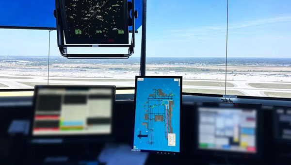
uAvionix has successfully installed and approved its surface situational awareness systems at two major U.S. airports: Indianapolis International Airport (IND) and Austin-Bergstrom International Airport (AUS). Developed in collaboration with Capital Sciences, the systems have passed the Service Acceptance Test (SAT) and will be operational for Air Traffic Control (ATC) starting June 30, 2024.
“This milestone marks the first approvals under the Federal Aviation Administration (FAA) Surface Awareness Initiative (SAI), part of a broader effort to enhance runway safety across the nation,” said Christian Ramsey, chief commercial officer for uAvionix.
The uAvionix systems use the Automatic Dependent Surveillance-Broadcast (ADS-B) service called FlightLine, which offers controllers real-time, precise depictions of aircraft and vehicles on the airport surface. This technology seeks to improve situational awareness and reduce the risk of runway incursions.
The delivery of the FlightLine systems to IND and AUS was completed and accepted within a 90-day timeframe, thanks to close collaboration with the FAA, National Air Traffic Control Association (NATCA), Indianapolis Airport Authority and AUS.
Each airport also installed several of uAvionix’s VTU-20 ADS-B Vehicle Movement Area Transmitters (VMATs) on airport vehicles. The VTU-20 is an FAA-approved system that allows vehicles operating on runways and taxiways to be electronically seen by the tower and aircraft equipped with ADS-B In technologies, further reducing the risk of runway incursions.
Following the success of these implementations, uAvionix will continue working with the FAA to expand the capability to other airports nationwide.
Key benefits of the enhanced system include:
Improved real-time tracking of aircraft and vehicles on the airfield.
Increased safety and efficiency in all weather conditions.
Decreased risk of runway incursions due to timely and accurate data.